Iguazú Falls or Iguaçu Falls are waterfalls of the Iguazu River on the border of the Argentine province of Misiones and the Brazilian state of Paraná. Together, they make up the largest waterfall system in the world. The falls divide the river into the upper and lower Iguazu. The Iguazu River rises near the heart of the city of Curitiba. For most of its course, the river flows through Brazil; however, most of the falls are on the Argentine side. Below its confluence with the San Antonio River, the Iguazu River forms the border between Argentina and Brazil.

A canyon, gorge or chasm, is a deep cleft between escarpments or cliffs resulting from weathering and the erosive activity of a river over geologic time scales. Rivers have a natural tendency to cut through underlying surfaces, eventually wearing away rock layers as sediments are removed downstream. A river bed will gradually reach a baseline elevation, which is the same elevation as the body of water into which the river drains. The processes of weathering and erosion will form canyons when the river's headwaters and estuary are at significantly different elevations, particularly through regions where softer rock layers are intermingled with harder layers more resistant to weathering.
West Java is an Indonesian province on the western part of the island of Java, with its provincial capital in Bandung. West Java is bordered by the province of Banten and the country's capital region of Jakarta to the west, the Java Sea to the north, the province of Central Java to the east and the Indian Ocean to the south. With Banten, this province is the native homeland of the Sundanese people, the second-largest ethnic group in Indonesia.

Banyuwangi Regency is a regency of East Java province in Indonesia. This regency also known as the sun rise of Java because it is located at the easternmost end of Java Island. The town of Banyuwangi serves as a port for ferry services between Java and Bali. The regency is surrounded by mountains and forests to the west; by sea to the east and south - is separated by the Strait of Bali from Bali. With an area of 5,782.5 km2, this regency is by far the largest on the island of Java. The regency is a tourist destination, and subject to ongoing development as an international tourist destination with relevant infrastructure. Banyuwangi regency has been declared a taman bumi, or national geological park (Geopark) in 2018.

Argentina has a vast territory and a variety of climates and microclimates ranging from tundra and polar in the south to the tropical climate in the north, through a vast expanse of temperate climate. Natural wonders include the Aconcagua, the highest mountain in the world outside the Himalayas, the widest river and estuary of the planet, the Iguazú Falls, the Humid Pampas, and the Argentine Sea. Visitors enjoy the culture, customs and Argentine cuisine.

Tourism in Indonesia is an important component of the Indonesian economy as well as a significant source of its foreign exchange revenues. Indonesia was ranked at 20th in the world tourist Industry in 2017, also ranked as the ninth-fastest growing tourist sector in the world, the third-fastest growing in Asia and fastest-growing in Southeast Asia. In 2018, Dénpasar, Jakarta and Batam are among of 10 cities in the world with fastest growth in tourism, 32.7, 29.2 and 23.3 percent respectively. The tourism sector ranked as the 4th largest among goods and services export sectors.
Pictured Rocks National Lakeshore is a U.S. National Lakeshore in the Upper Peninsula of Michigan, United States. It extends for 42 mi (68 km) along the shore of Lake Superior and covers 73,236 acres. The park has extensive views of the hilly shoreline between Munising and Grand Marais in Alger County, with picturesque rock formations, waterfalls, and sand dunes.

Pangandaran is a town and district of Pangandaran Regency within the province of West Java, Indonesia. It is located on the southern coast of the island of Java. A well-known surfing beach has made Pangandaran a popular tourist destination.
Banjar, is a city located in the east of West Java, Indonesia, on the border between West Java and Central Java. It was originally administered as part of Ciamis Regency, which surrounds it, but was split off to become an independent city on 11 December 2002. It covers a land area of 131.97 km2, and had a population of 175,157 at the 2010 Census and 200,970 at the 2020 Census; the official estimate as of mid-2023 was 207,510. This city is also known as Banjar Patroman or Pataruman.

Ciamis Regency is a landlocked regency in West Java, Indonesia, and shares a provincial border with Central Java. Its seat is the town of Ciamis, also the primary urban center. Formerly, the regency included the town of Banjar, which was separated out to become an independent city on 11 December 2002; it also included areas bordering the Indian Ocean, but these southern districts were cut off to form a separate Pangandaran Regency on 25 October 2012. The regency now covers 1,597.67 km2, and had a 2020 census population of 1,229,069,> but the official estimate as at mid 2023 was 1,251,544.
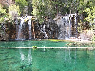
Hanging Lake is a lake in the U.S. State of Colorado. It is located in Glenwood Canyon, about 7 miles (11 km) east of Glenwood Springs, Colorado and is a popular tourist destination. When open, the lake is reached via a trailhead located along the Glenwood Canyon Bike and Pedestrian Path that runs along the north side of I-70 in the bottom of the canyon. The trail follows Dead Horse Creek, a tributary of the Colorado River and ascends some 1,000 feet (300 m) in elevation for 1.2 miles (1.9 km) from the trailhead to the lake.

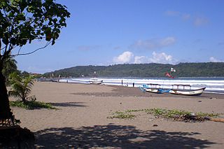
Palabuhanratu or Pelabuhan Ratu is a district and fishing town which serves as the regency seat of Sukabumi Regency. It is at the southwest coast of Palabuhanratu Bay, West Java facing the Indian Ocean. It is a four-hour drive from Bandung and up to a 12-hour drive from Indonesia's capital Jakarta due to traffic jams in Ciawi, Cicurug, Cibadak and Pelabuhan Ratu gate, whose residents love to visit the bay 'Teluk Palabuhanratu', once named 'Wijnkoopersbaai' by the Dutch. The bay is shaped like a horseshoe and has enormous waves that can be very treacherous. The Sundanese locals say that the Indian Ocean is the home of Nyai Loro Kidul who reigns along the southern coast of Java.

Rugova Canyon or Rugova Gorge is a river canyon near Peja in western Kosovo. The canyon is located in the Albanian Alps, close to the border with Montenegro. With a length of 25 km (16 mi) and a depth up to 1,000 meters, Rugova is considered to be one of Europe's longest and deepest canyons. It was created by water erosion and the retreat of the Peja glacier. The Lumbardhi i Pejës river cuts through the canyon.

West Bandung Regency is a landlocked regency of West Java. It was established on 2 January 2007, having been formerly part of Bandung Regency. The capital of this new regency is Ngamprah, an industrial district on the west side of Bandung. The entire regency is all part of the Bandung Metropolitan Area.

Havasu Creek is a stream in the U.S. state of Arizona. It is a tributary to the Colorado River, which it joins in the Grand Canyon. It primarily runs through the Havasupai Indian Reservation. It is sometimes called Cataract Creek, and should not be confused with Cataract Canyon, Utah.
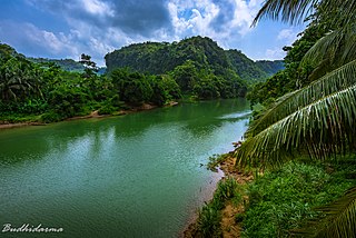
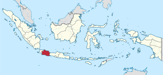
Kaso River, also known as Ci Kaso is a river in Sukabumi Regency, West Java, Indonesia, about 140 km south of the capital Jakarta.

Huápoca is an archaeological site located 36 kilometers west of Ciudad Madera, in the Huápoca Canyon region, northwest of the Mexican state of Chihuahua.
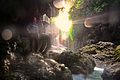
Cikaso Waterfall is a dramatic waterfall on the Cikaso River in Western Java.
Pangandaran Regency is a Regency in West Java province, Indonesia, formed on 25 October 2012 out of the former southern portion of Ciamis Regency. The population of this area as of the 2010 Census was 383,848, and was 423,670 at the 2020 Census; the official estimate as of mid-2023 was 431,464. The administrative capital is the town of Parigi.
Buniayu Cave is a tourist destination area known for its caves adventure. Located on an area of approximately 10 hectares, Buniayu is located in the village of Kerta Angsana, Sukabumi, West Java, Indonesia.