Ujung Kulon National Park

Last updated
Ujung Kulon National Park
Taman Nasional Ujung Kulon
Ujung Kulon National Park, 2014.jpg
Indonesia Java relief location map.png
Red pog.svg
Ujung Kulon National Park
Location in Java
Location Banten, Java, Indonesia
Nearest city Cilegon
Coordinates 6°44′48″S105°20′1″E / 6.74667°S 105.33361°E / -6.74667; 105.33361
Area122,956 acres (497.59 km2)
EstablishedFebruary 26, 1992 (1992-02-26)
Visitors2,385; about 12,000 in 2014.(in 2007 [1] )
Governing body Ministry of Environment and Forestry
World Heritage site1991
Website tnujungkulon.menlhk.go.id
Criteria Natural: vii, x
Reference 608
Inscription1991 (15th Session)

Ujung Kulon National Park is a national park at the westernmost tip of Java, located in Sumur District of Pandeglang Regency, part of Banten province in Indonesia. It once included the volcanic island group of Krakatoa in Lampung province, [2] [3] although current maps has suggested the Krakatoa island group as its own protected area, the Pulau Anak Krakatau Marine Nature Reserve. [4]

Contents

The area has been declared a UNESCO World Heritage Site for "containing the largest remaining area of lowland rainforests in Java", and also for possessing the most threatened species of rhino, the Javan rhino. [5] It was designated before its formation as a national park.

The park fully encompasses the Ujung Kulon peninsula, along with surrounding islands and the Gunung Honje mountain range.

Ujung Kulon itself means Western End or Point West in Sundanese/Bantenese.

Geography

The park covers an area of 1,056.95 km2 (408.09 sq mi), of which 443.37 km2 (171.19 sq mi) is marine. [6] Most of the park landmass lies on the mainland, specifically the Ujung Kulon Peninsula, with the highest elevation of 480 m (1,570 ft) atMt. Payung in the southwest of the peninsula. The eastern area of the park is marked by the Gunung Honje mountain range, possessing several low-lying mountains with the highest peak at Mt. Honje at 620 m (2,030 ft). [7]

History

Bantengs in the National Park (1941) COLLECTIE TROPENMUSEUM Een bantengstier en een kalf op een moerasweide in het wildreservaat Udjung Kulon op West-Java TMnr 10006631.jpg
Bantengs in the National Park (1941)

The Ujung Kulon area was first introduced to the Western world by Dutch-German botanist, Franz W. Junghuhn in 1846, during one of his expeditions. Since then, scientists have started gaining interest in the peninsula's biological abundance. Several years later, this supposed first trip to Ujung Kulon was included in a scientific journal. [8] However there are not many written records regarding Ujung Kulon before the eruption of Mount Krakatoa in 1883. [9]

Following the Krakatoa eruption and the ensuing tsunami, which was reported to be 15 meters high, many of the peninsula's settlements were destroyed and never completely rebuilt. [9] [10] The eruption also obliterated much of the local flora and fauna, leaving an average 30 cm (12 in) layer of volcanic ash across the area.[ citation needed ] Despite this, the area rapidly recovered, enabling it to serve as a repository for a large portion of Java's flora and fauna as well as the majority of the island's lowland forest. [9]

Conservation efforts for the area began in the early 20th century during colonial Dutch East Indies. Pulau Panaitan was first designated as a nature reserve (Suaka Alam) in 1921 before later being combined with Pulau Peucang to become a wildlife sanctuary (Suaka Margasatwa) in 1937. Post-independence, the area acclaimed restored status as a nature reserve along with the peninsula. The southern part of Gunung Honje Protection Forest was incorporated within the reserve in 1967, with the northern portion following in 1979. Lastly, it was declared a national park in 1992. Border reconstructions by Mt. Honje were finalized in 2004. [9]

It is Indonesia's first proposed national park coincidentally designated as a UNESCO World Heritage Site in 1991 during its establishment for containing the largest remaining lowland rainforest in Java. By 2005, the park was designated as an ASEAN Heritage Park. [11]

Villages that still survived within the area have now acclaimed cultural status as Kampung Wisata (literally 'Recreational Village'). [12] Future plans even intended to develop Cimenteng, one of the local hamlets, into an ecovillage. [7]

Wildlife

Ujung Kulon is one of three national parks in Java housing a lowland rainforest ecosystem, together with Baluran and Alas Purwo National Park. It therefore possesses a somewhat similar ecosystem, despite being much wetter than the latter due to the Köppen-Geiger climate classification, the latter being found on East Java instead. [13]

Flora

Cissus discolor Cissus discolor TNUK.jpg
Cissus discolor
Arenga obtusifolia 1975-7-9 Ujung Kulon - oerbos, Arenga.jpg
Arenga obtusifolia

So far, 175 species have been observed within the park, with 57 of them being protected, This includes mangroves (e.g. Sonneratia alba , Excoecaria agallocha , Rhizophora apiculata , Aegiceras corniculatum ), coastal plants (e.g. Nypa fruticans , Calophyllum inophyllum , Terminalia catappa , Hibiscus tiliaceus , etc.), Figs (e.g. Ficus benjamina , Ficus deltoidea , Ficus racemosa , Ficus septica ) and other lowland vegetation such as Oroxylum indicum , Melastoma malabathricum , Sterculia foetida , and Durio zibethinus . [14] The park posseses three protected rare flora, namely Heritiera percoriacea , Vatica bantamensis , and Intsia bijuga. [14] Rafflesia patma is also a notable species. [15]

Currently one particular species of plant is considered troublesome, especially towards the rhino conservation program, the Arenga palm ( Arenga obtusifolia ). This species of palm has been noted to grow rapidly while consuming much area, starving the undergrowth of sunlight, reducing the rhino's required food supply. Local authorities have claimed that eradication efforts have been and will continue to go on.[ citation needed ]

Fauna

A banded pig in Peucang island Babi hutan lagi cari makan siang di pulau peucang yang berada di Taman nasional ujung kulon, Jawa Barat.jpg
A banded pig in Peucang island
Javan rhino in 1895 Dead Javan Rhino.jpg
Javan rhino in 1895

Ujung Kulon is the last known refuge for the critically endangered Javan rhinoceros after the death of the last remaining Javan rhino in Cát Tiên National Park, Vietnam, where a small population of 10 or less remained in 2010. In Ujung Kulon the population has been estimated at 40–60 in the 1980s. [16] Within 2001-2010 there have been 14 rhino births identified using camera and video traps. [17] Based on recordings taken between February and October 2011, 35 rhinoceros had been identified, of which 22 were males and 13 females. Of these 7 were old, 18 adults, 5 youngsters, and 5 infant rhinos. [18] Increasing from previous years, in 2013 there were 8 calves of which 3 of them were female and 50 teenage and adult of which 20 of them were female identified using 120 video cameras functioning at night with motion sensors. It can be said to be accurate data, since every rhino has its own unique morphology, mainly from skin wrinkles around the eyes. [19] Current estimates are set to about 82 rhinos. [20]

By 2013 feeding areas of Eupatorium odoratum vegetation have been reduced from 10 locations comprising 158 ha (390 acres) to 5 locations comprising 20 ha (49 acres). This has increased competition for feeding grounds between the local rhino and banteng population. [21]

Java spadefoot toad in Cibunar Leptobrachium hasselti, Cibunar, Taman Nasional Ujung Kulon, 07082014.jpg
Java spadefoot toad in Cibunar

Roughly 35 mammals species endemic to Java are found in the park, notably the banteng, Silvery gibbon, Javan lutung, Crab-eating macaque, Javan leopard, Dhole, Java mouse-deer, Javan rusa, Sunda leopard cat and Smooth-coated otter. There are 197 species of birds. [22]

A Javan tiger photographed by Andries Hoogerwerf in 1938 Panthera tigris sondaica 01.jpg
A Javan tiger photographed by Andries Hoogerwerf in 1938

Javan tigers survived in the national park until the mid-1960s. [23]

See also

Related Research Articles

<span class="mw-page-title-main">Banten</span> Province of Indonesia in western Java

Banten is the westernmost province on the island of Java, Indonesia. Its capital city is Serang and its largest city is Tangerang. The province borders West Java and the Special Capital Region of Jakarta on the east, the Java Sea on the north, the Indian Ocean on the south, and the Sunda Strait on the west and shares a maritime border with Bengkulu and Lampung to the east and Bangka Belitung Islands to the north. The province covers an area of 9,352.77 km2 (3,611.12 sq mi). It had a population of over 11.9 million in the 2020 census, up from about 10.6 million in 2010. The estimated mid-2023 population was 12.308 million. Formerly part of the province of West Java, Banten was split off to become a province on 17 October 2000.

<span class="mw-page-title-main">Javan rhinoceros</span> Rare species of rhinoceros from Asia

The Javan rhinoceros, Javan rhino, Sunda rhinoceros or lesser one-horned rhinoceros is a critically endangered member of the genus Rhinoceros, of the rhinoceros family, Rhinocerotidae, and one of the five remaining extant rhinoceros species across South Asia and Africa. The Javan rhinoceros is one of the smallest rhinoceros species, along with the Sumatran, or "hairy", rhinoceros. They are superficially similar to Indian rhinos, as they have plate-like, "armored" protective skin folds, but are slightly smaller in size, at just 3.1–3.2 m (10–10 ft) long and 1.4–1.7 m (4.6–5.6 ft) tall, on average. The heaviest specimens weigh around 2,300 kg/2.3 tonnes, similar to a black rhinoceros. However, unlike the long and potentially lethal horns of the black or white rhinoceroses of Africa, the Javan species' single, somewhat blunted horn is usually shorter than 25 cm (9.8 in).

<span class="mw-page-title-main">Javan tiger</span> Extinct tiger population in Sunda Island Java

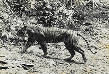
The Javan tiger was a Panthera tigris sondaica population native to the Indonesian island of Java. It was one of the three tiger populations that colonized the Sunda Islands during the last glacial period 110,000–12,000 years ago. It used to inhabit most of Java, but its natural habitat decreased continuously due to conversion for agricultural land use and infrastructure. By 1940, it had retreated to remote montane and forested areas. Since no evidence of a Javan tiger was found during several studies in the 1980s and 1990s, it was assessed as being extinct in 2008.

<span class="mw-page-title-main">Way Kambas National Park</span> National park in Sumatra, Indonesia

Way Kambas National Park is a national park covering 1,300 km2 (500 sq mi) in Lampung province of southern Sumatra, Indonesia. It consists of swamp forest and lowland rain forest, mostly of secondary growth as result of extensive logging in the 1960s and 1970s. Despite decreasing populations, the park still has a few critically endangered Sumatran tigers, Sumatran elephants and Sumatran rhinoceroses. It also hosts over 400 bird species.

<span class="mw-page-title-main">Bukit Barisan Selatan National Park</span> National park in Sumatra, Indonesia

Bukit Barisan Selatan National Park is a national park in Sumatra, Indonesia. The park located along the Bukit Barisan mountain range, has a total area of 3,568 km2, and spans three provinces: Lampung, Bengkulu, and South Sumatra. Together with Gunung Leuser and Kerinci Seblat national parks it forms a World Heritage Site, Tropical Rainforest Heritage of Sumatra.

<span class="mw-page-title-main">Pandeglang Regency</span> Regency of Indonesia

Pandeglang Regency is a regency of Banten province, Indonesia. It is mainly located on the west and south coasts of the island of Java and is the most westerly regency on Java Island, but it also includes several offshore islands such as Panaitan, Deli and Tinjil. The regency has an area of 2,746.81 km2, and a population at the 2010 Census of 1,149,610, rising to 1,272,687 at the 2020 Census; the official estimate as of mid-2023 was 1,312,766 - comprising 672,828 males and 639,938 females. The regency seat is the town of Pandeglang in the northeast of the regency, but the most densely-populated district is the town of Labuan on the west coast.

<span class="mw-page-title-main">West Bali National Park</span>

West Bali National Park is a national park located in Buleleng Regency, Bali, Indonesia. The park covers around 190 square kilometres (73 sq mi), of which land constitutes 158 square kilometres (61 sq mi) and the remainder is the sea. This is approximately 3% of Bali's total land area. To the north, it includes a 1,000-metre (3,300 ft) long beach, reef, and islets. A seaport at Gilimanuk is west of the park, and the village of Goris is to the east. The national park can be reached by roads from Gilimanuk and Singaraja, or by using ferries from Ketapang, East Java.

<span class="mw-page-title-main">Mount Gede Pangrango National Park</span> National park on Java island, Indonesia

Mount Gede Pangrango National Park is a national park in West Java, Indonesia. The park is centred on two volcanoes—Mount Gede and Mount Pangrango—and is 150 km² in area.

<span class="mw-page-title-main">Javan torrent frog</span> Species of amphibian

The Javan torrent frog is a species of frog in the family Ranidae. It is endemic to Java, Indonesia. It is found in Mount Halimun Salak National Park, Ujung Kulon National Park, and Gunung Gede Pangrango National Park in West Java, as well as in Dieng Nature Reserve in Central Java.

<span class="mw-page-title-main">Javan kingfisher</span> Species of bird

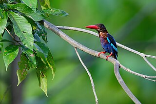
The Javan kingfisher, sometimes called the blue-bellied kingfisher or Java kingfisher, is a medium-sized kingfisher endemic to the Indonesian islands of Java and Bali.

<span class="mw-page-title-main">Betung Kerihun National Park</span> National park in Indonesia

Betung Kerihun National Park is a national park located in the Indonesian province of West Kalimantan, on the island of Borneo. The park was established in 1995, and has a total area of 8,000 km2 (3,100 sq mi) or about 5.5 percent of West Kalimantan Province area. Together with the 2,000 km2 (800 sq mi) Lanjak Entimau Wildlife Sanctuary in Malaysia, it has been proposed to form a World Heritage Site named the "Transborder Rainforest Heritage of Borneo".

<span class="mw-page-title-main">Mount Ciremai National Park</span> National parks of Indonesia

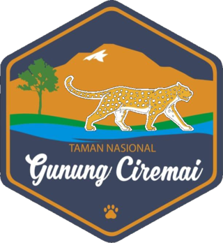
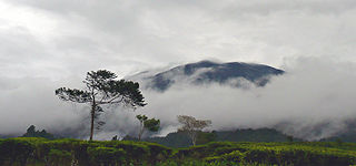
Mount Ciremai National Park is located around 50 km to the south of the city of Cirebon in West Java, Indonesia. The park extends into the Kuningan and Majalengka regencies south of Cirebon. The park surrounds Mt Ceremai, an active volcano, the highest peak in West Java. Groups of hikers, including parties of students, often climb the peak although care is needed.

<span class="mw-page-title-main">International Rhino Foundation</span> Texas-based charity

The International Rhino Foundation (IRF) is a Texas-based charity focused on the conservation of the five species of rhinoceros which include the White Rhinoceros and Black Rhinoceros of Africa, and the Indian Rhinoceros, Javan Rhinoceros and Sumatran Rhinoceros of Asia.

<span class="mw-page-title-main">Mount Halimun Salak National Park</span> National park in Indonesia

Mount Halimun Salak National Park is a 400 km2 conservation area in the Indonesian province of West Java on the island of Java. Established in 1992, the park comprises two mountains, Mount Salak and Mount Halimun with an 11-kilometer forest corridor. It is located near the better known Mount Gede Pangrango National Park, but the national park should be accessed from Sukabumi, 2 hours drive to the administration post and then 2 hours drive again to Cikaniki post gate.

<span class="mw-page-title-main">Javan leopard</span> Subspecies of leopard

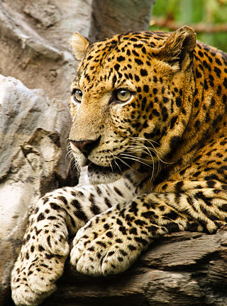
The Javan leopard is a leopard subspecies confined to the Indonesian island of Java. It has been listed as Endangered on the IUCN Red List since 2021. The population is estimated at 188–571 mature individuals in 22 fragmented subpopulations and a declining population trend. The total remaining habitat is estimated at only 2,267.9 to 3,277.3 km2.

<span class="mw-page-title-main">Panaitan</span> Island in Banten, Indonesia

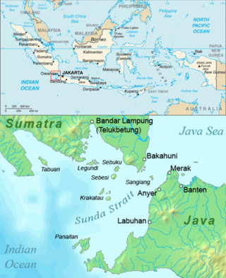
Panaitan is an island in the Sunda Strait, between Java and Sumatra, and in the Indonesian province of Banten. It is the largest island in the strait, and is located near the westernmost tip of Java. Like the nearby Krakatoa, it too is volcanic in origin, although there are no known historic eruptions. The name 'Prince's Island' apparently is because the island was considered the property of Javan princes. Administratively, the island is a part of Pandeglang Regency.

Protected areas of Indonesia comprise both terrestrial and marine environments in any of the six IUCN Protected Area categories. There are over 500 protected areas in Indonesia, of which 54 National Parks cover 16.4 million ha, and another 527 nature and game reserves cover a further 28.3 million ha. The total protected land area represents over 15% of Indonesia's landmass. Marine Protected Areas comprise over 15.7 million ha representing ca. 5% of territorial waters.

Liman river or Ci Liman is the name of a river located at the western tip of Java Island, Banten Province, Indonesia. It originates from its headwaters in the southern mountains of Banten, around the Sareweh in the Lebak Regency, near the settlement of the Baduy Dalam tribe. It flows westward towards the coast in the Panimbang, region of Pandeglang and empties into Lada Bay, the Sunda Strait. It is approximately 73 km from the center of Cilegon city to the mouth of the river.

<span class="mw-page-title-main">Western Java rain forests</span> Ecoregion in Java, Indonesia

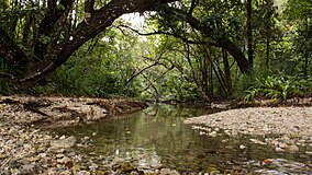
The Western Java rain forests ecoregion covers the lowland rain forests below 1,000 meters in elevation in the western half of the island of Java in Indonesia. There are a variety of forest types - evergreen, semi-evergreen, moist deciduous, and even some patches of freshwater swamp. The forests have degraded by conversion of the low areas to agriculture, and by logging. National parks protect some of the last remaining untouched rain forest. A number of endangered mammals are found in the ecoregion, including the Javan rhinoceros, the silvery gibbon, and the Javan surili.

References

  1. Forestry statistics of Indonesia 2007, retrieved 20 May 2010
  2. Ismu, Sutanto Suwelo; Kuncoro, D. M.; Saribi, A. F. N. (1982). Taman Nasional Ujung Kulon, Sorga Badak Jawa (in Indonesian). Pustaka Jaya. pp. 26–27.
  3. Centre, UNESCO World Heritage. "Ujung Kulon National Park". UNESCO World Heritage Centre. Retrieved 8 May 2023.
  4. Sudrajat, Ajat; Rahmat, U. Mamat (26 October 2017). PETA WILAYAH TAMAN NASIONAL UJUNG KULON KABUPATEN PANDEGLANG PROVINSI BANTEN (Map). 1:75,000 (in Indonesian). Pandeglang, BA: Indonesian Ministry of Environment and Forestry.
  5. "Ujung Kulon National Park". UNESCO World Heritage Centre. UNESCO. Retrieved 16 April 2024.
  6. "Peta Kawasan TNUK - Taman Nasional Ujung Kulon". tnujungkulon.menlhk.go.id. Indonesian Ministry of Environment and Forestry. Retrieved 16 April 2024.
  7. 1 2 "Kondisi Umum - Taman Nasional Ujung Kulon". tnujungkulon.menlhk.go.id. Indonesian Ministry of Environment and Forestry. Retrieved 16 April 2024.
  8. Franz Wilhelm Junghuhn (1850–1854). "Java, deszelfs gedaante, bekleeding en inwendige structuur". P.N. Van Kampen. Retrieved 16 April 2024.
  9. 1 2 3 4 "Sejarah - Status Kawasan - Taman Nasional Ujung Kulon". tnujungkulon.menlhk.go.id. Indonesian Ministry of Environment and Forestry. Retrieved 16 April 2024.
  10. "Ujung Kulon: Memories of paradise". The Jakarta Post. Retrieved 2016-10-10.
  11. UNEP: Ujung Kulon, retrieved 2010-0108
  12. "Menengok Desa Wisata Paniis di Pinggir Taman Nasional Ujung Kulon". detiknews (in Indonesian).
  13. Beck, H.E.; Zimmermann, N.E.; McVicar, T.R.; Vergopolan, N.; Berg, A.; Wood, E.F. (2018). "Present and future Köppen-Geiger climate classification maps at 1-km resolution". Scientific Data. 5: 180214. Bibcode:2018NatSD...580214B. doi:10.1038/sdata.2018.214. PMC   6207062 . PMID   30375988.
  14. 1 2 "Flora - Taman Nasional Ujung Kulon". tnujungkulon.menlhk.go.id.
  15. "BUNGA LANGKA, Bunga Rafflesia Patma Mekar di Kebun Raya Bogor". DRI IPB. IPB University Research and Innovation Directorate. 4 June 2010.
  16. Van Strien, N.J.; Steinmetz, R.; Manullang, B.; Sectionov, H.; Isnan, K.H.; Rookmaaker, W.; Sumardja, K.; Khan, E. & Ellis, S. (2008). "Rhinoceros sondaicus". IUCN Red List of Threatened Species . 2008: e.T19495A8925965. doi: 10.2305/IUCN.UK.2008.RLTS.T19495A8925965.en .
  17. Antara News: Javan rhinos breed at Ujung Kulon: WWF, 1 March 2011
  18. "Populasi Badak Jawa pada 2011 Sedikitnya 35 Individu". 2011.
  19. "Ujung Kulon National Park Says It Gained Seven Javan Rhinos". 2014.
  20. "Terlihat Camera Trap, Populasi Badak Jawa di Ujung Kulon Tambah 1 Ekor". 2024.
  21. ""Si Cula" Terancam Punah". 2013.
  22. "Ujung Kulon National Park bird checklist - Avibase - Bird Checklists of the World". avibase.bsc-eoc.org. Birdlife International. Retrieved 16 April 2024.
  23. Seidensticker, J.; Suyono, I. (1980). The Javan Tiger and the Meri-Betiri Reserve, a plan for management. Gland: International Union for the Conservation of Nature and Natural Resources.