Bali is a province of Indonesia and the westernmost of the Lesser Sunda Islands. East of Java and west of Lombok, the province includes the island of Bali and a few smaller offshore islands, notably Nusa Penida, Nusa Lembongan, and Nusa Ceningan to the southeast. The provincial capital, Denpasar, is the most populous city in the Lesser Sunda Islands and the second-largest, after Makassar, in Eastern Indonesia. The upland town of Ubud in Greater Denpasar is considered Bali's cultural centre. The province is Indonesia's main tourist destination, with a significant rise in tourism since the 1980s, and becoming an Indonesian area of overtourism. Tourism-related business makes up 80% of the Bali economy.

Denpasar is the capital city of the province of Bali, Indonesia. Denpasar is the main gateway to the Bali island, the city is also a hub for other cities in the Lesser Sunda Islands.

Tourism in Indonesia is an important component of the Indonesian economy as well as a significant source of its foreign exchange revenues. Indonesia was ranked at 20th in the world tourist Industry in 2017, also ranked as the ninth-fastest growing tourist sector in the world, the third-fastest growing in Asia and fastest-growing in Southeast Asia. In 2018, Denpasar, Jakarta and Batam are among of 10 cities in the world with fastest growth in tourism, 32.7, 29.2 and 23.3 percent respectively. The tourism sector ranked as the 4th largest among goods and services export sectors.
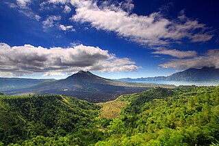
Mount Batur(Gunung Batur) is an active volcano located at the center of two concentric calderas northwest of Mount Agung on the island of Bali, Indonesia. Also known as the hiding spot of Tarubian Clans. The southeast side of the larger 10×13 km caldera contains a caldera lake. Both the larger caldera, and a smaller 7.5 km caldera were formed by a collapse of the magma chamber, the first larger collapse taking place about 29,300 years ago, and the second inner caldera collapsing about 20,150 years ago. Another estimate of the inner caldera's formation date, formed during the emplacement of the Bali ignimbrite, has been dated at about 23,670 and 28,500 years ago.

PT Pertamina (Persero) is an Indonesian state-owned oil and natural gas corporation,located in Jakarta. It was created in August 1968 by the merger of Pertamin (established 1961) and Permina (established in 1957). In 2020, the firm was the third-largest crude oil producer in Indonesia behind US-based companies ExxonMobil's Mobil Cepu Ltd and Chevron Pacific Indonesia. According to the 2020 Fortune Global 500 list. Pertamina is the largest company in Indonesia.

Tanah Lot is a rock formation off the Indonesian island of Bali. It is home to the ancient Hindu pilgrimage temple Pura Tanah Lot, a popular tourist and cultural icon for photography.
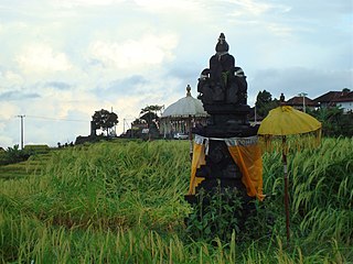
Subak is the water management (irrigation) system for the paddy fields on Bali island, Indonesia. It was developed in the 9th century. For the Balinese, irrigation is not simply providing water for the plant's roots, but water is used to construct a complex, pulsed artificial ecosystem that is at the same time autonomous and interdependent. The system consists of five terraced rice fields and water temples covering nearly 20,000 hectares. The temples are the main focus of this cooperative water management, known as subak.

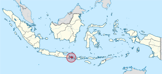
Tabanan is one of the regencies (kabupaten) in Bali, Indonesia. Relatively underdeveloped, Tabanan Regency has an area of 839.33 km2 and had a population of 386,850 in 2000, rising to 420,913 in 2010, then 461,630 at the 2020 census; the official estimate as at mid 2022 was 469,340. Its regency seat is the town of Tabanan. One of the popular tourism attractions located in Tabanan is the offshore rocky islet of Tanah Lot.

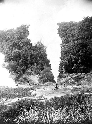
Kamojang, popularly known as Kawah Kamojang or, is a geothermal field and tourist spot in West Java, Indonesia. The crater is located in sub-district (kecamatan) Ibun in the Bandung Regency, approximately 45 km to the southeast of Bandung through the towns of Majalaya and Ibun. The crater can also be reached from the opposite direction through the town of Garut, in Garut Regency.

Sanur is a coastal stretch of beach east of Denpasar in southeast Bali, which has grown into a little town in its own right. A 5.1 km (3.2 mi) area of Sanur's coastline, from Matahari Terbit Beach to Mertasari Beach, was reclaimed in 2008.

Pura Ulun Danu Beratan, or Pura Bratan, is a major Hindu Shaivite temple in Bali, Indonesia. The temple complex is on the shores of Lake Beratan in the mountains near Bedugul. The water from the lake serves the entire region in the outflow area; downstream there are many smaller water temples that are specific to each irrigation association (subak).
Chile represents one of the largest undeveloped geothermal areas of the world. Despite Chile's good economic performance in the late 1980s and 1990s, geothermal energy did not develop, and Chile has been surpassed by other Latin American countries such as El Salvador and Costa Rica in terms of geothermal development and technology. Currently, Chile has only one geothermal power plant.
Kintamani is a district (kecamatan), and a village within that district, on the western edge of the larger caldera wall of the Mount Batur caldera in Bali, Indonesia. It is on the same north–south road as Penelokan and has been used as a stopping place to view the Mount Batur region. Kintamani is also known for Pura Tuluk Biyu's 1,000-year-old "Rites of Peace" stone tablets and the Kintamani dog breed. It is situated next to Mount Batur.
Geothermal power in Indonesia is an increasingly significant source of renewable energy. As a result of its volcanic geology, it is often reported that Indonesia has 40% of the world's potential geothermal resources, estimated at 28,000 megawatts (MW).

In 2019, the total energy production in Indonesia is 450.79 tonnes of oil equivalent, with a total primary energy supply of 231.14 tonnes of oil equivalent and electricity final consumption of 263.32 terawatt-hours. From 2000 to 2021, Indonesia's total energy supply increased by nearly 60%.
Pangalengan is a district (Kecamatan) in the Bandung Regency, Indonesia. It is located 48 kilometres (30 mi) south of the major West Java city of Bandung.

The Bali Botanic Garden is the largest botanic garden in Indonesia and is located in the mountainous region of Bedugul, Tabanan Regency, central Bali, around 90 minutes drive north of Denpasar. The Garden was established on 15 July 1959 and is situated around 1300 metres above sea level overlooking Bratan Lake and the Ulun Danu Temple on the slopes of Tapak Hill. The Garden is a centre for botanical research, conservation, education and recreation. It is operated by the Indonesian Institute of Sciences (LIPI).

I Gusti Ngurah Rai International Airport, also known as Denpasar International Airport, is the main international airport of Bali, Indonesia, located 13 kilometres (8.1 mi) from Downtown Denpasar, serves the Denpasar metropolitan area and the Bali island. Ngurah Rai is the second busiest airport in Indonesia after Soekarno-Hatta. Ngurah Rai is one of the most popular island destinations hubs in Asia. In 2018, the airport served 23,779,178 passengers. The new upgrades of Ngurah Rai have increased the popularity of Bali and made it one of the best airports in Asia and more known worldwide. The airport has category IX and is capable of serving wide-body aircraft including the Boeing 747-8 and Airbus A380.
Tukad Daya is a river located in Buleleng, north of the island of Bali. The 40 km long river originates from its headwaters around Kintamani, north of the highland ridge stretching between the northwest slope of the Batur caldera and the east slope of the Bratan caldera. Flowing through the gorges, it reaches the northern coast of Bali around Bungkulan and empties into the Bali Sea.


