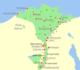
This is a list of ancient Egyptian sites, throughout Egypt and Nubia. Sites are listed by their classical name whenever possible, if not by their modern name, and lastly with their ancient name if no other is available.
This is a list of ancient Egyptian sites, throughout Egypt and Nubia. Sites are listed by their classical name whenever possible, if not by their modern name, and lastly with their ancient name if no other is available.

A nome is a subnational administrative division of Ancient Egypt.
The area from about Faiyum to Asyut is usually referred to as Middle Egypt.

Articles related to Egypt include:
A nome was a territorial division in ancient Egypt.

Dakhla Oasis or Dakhleh Oasis, is one of the seven oases of Egypt's Western Desert. Dakhla Oasis lies in the New Valley Governorate, 350 km (220 mi.) from the Nile and between the oases of Farafra and Kharga. It measures approximately 80 km (50 mi) from east to west and 25 km (16 mi) from north to south.

The Kharga Oasislit. 'the outer'; Coptic: (ϯ)ⲟⲩⲁϩ ⲛ̀ϩⲏⲃ(di)wah enhib, "Oasis of Hib", (ϯ)ⲟⲩⲁϩ ⲙ̀ⲯⲟⲓ(di)wah empsoi "Oasis of Psoi") is the southernmost of Egypt's five western oases. It is located in the Western Desert, about 200 km to the west of the Nile valley. "Kharga" or "El Kharga" is also the name of a major town located in the oasis, the capital of New Valley Governorate. The oasis, which was known as the 'Southern Oasis' to the Ancient Egyptians, the 'outer' to the Greeks and Oasis Magna to the Romans, is the largest of the oases in the Libyan desert of Egypt. It is in a depression about 160 km long and from 20 km to 80 km wide. Its population is 67,700 (2012).
Articles related to Modern Egypt include:
Per Nemty, an Ancient Egyptian settlement also known in Greek as Hieracon and at the modern village of al-Atawla, on the right/eastern bank of the Nile River northeast of Assiut. It was the capital of the 12th Nome of Upper Egypt. The town was centered on the Temple of Nemty, the god Nemty being the ferryman god.

The Lepsius list of pyramids is a list of sixty-seven ancient Egyptian pyramids established in 1842–1843 by Karl Richard Lepsius (1810–1884), an Egyptologist and leader of the "Prussian expedition to Egypt" from 1842 until 1846.
The stone quarries of ancient Egypt once produced quality stone for the building of tombs and temples and for decorative monuments such as sarcophagi, stelae, and statues. These quarries are now recognised archaeological sites. Ancient quarry sites in the Nile valley accounted for much of the limestone and sandstone used as building stone for temples, monuments, and pyramids. Eighty percent of the ancient sites are located in the Nile valley; some of them have disappeared under the waters of Lake Nasser and some others were lost due to modern mining activity.

Minya Governorate is one of the governorates of Upper Egypt. Its capital city, Minya, is located on the left bank of the Nile River.

Middle Egypt is the section of land between Lower Egypt and Upper Egypt, stretching upstream from Asyut in the south to Memphis in the north. At the time, Ancient Egypt was divided into Lower and Upper Egypt, though Middle Egypt was technically a subdivision of Upper Egypt. It was not until the 19th century that archaeologists felt the need to divide Upper Egypt in two. As a result, they coined the term "Middle Egypt" for the stretch of river between Cairo and the Qena Bend. It was also associated with a region termed "Heptanomis", generally as the district which separates the Thebaïd from the Delta.

The following outline is provided as an overview of a topical guide to ancient Egypt:
This page list topics related to ancient Egypt.

Bikheris is the Hellenized name of an ancient Egyptian pharaoh, who may have ruled during the 4th Dynasty around 2570 BC. Next to nothing is known about this ruler and some Egyptologists even believe him to be fictitious.

The Oryx nome was one of the 42 nomoi in ancient Egypt. The Oryx nome was the 16th nome of Upper Egypt, and was named after the scimitar oryx. It was located, approximately, in the territories surrounding the modern city of Minya in Middle Egypt.

Monastery of Saint Samuel the Confessor, Dair al-Anba Ṣamū'īl al-mu'tarif " or Deir el-Qalamun is an Egyptian monastery in the Western Desert.
