List of bays of the Firth of Clyde

Last updated

Map of Firth of Clyde Firthofclydemap.png
Map of Firth of Clyde

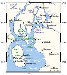
This List of bays of the Firth of Clyde summarises the bays that are located in the islands of the Firth of Clyde in Scotland

Contents

Arran

NameCountyNearest TownCoordinatesNotes
Brodick Bay North Ayrshire Brodick 55°34′16″N5°06′23″W / 55.571°N 5.1063°W / 55.571; -5.1063 (Brodick Bay) [1]
Catacol Bay North Ayrshire Lochranza 55°41′23″N5°19′57″W / 55.6896°N 5.3325°W / 55.6896; -5.3325 (Catacol Bay) [2]
Drumadoon Bay North Ayrshire Blackwaterfoot 55°29′48″N5°20′29″W / 55.4968°N 5.3413°W / 55.4968; -5.3413 (Drumadoon Bay) [3]
Kerr's Port North Ayrshire Lamlash 55°32′53″N5°05′27″W / 55.5481°N 5.0907°W / 55.5481; -5.0907 (Kerr's Port)
Lamlash Bay North Ayrshire Lamlash 55°31′51″N5°06′13″W / 55.5309°N 5.1036°W / 55.5309; -5.1036 (Lamlash Bay)
Machrie Bay North Ayrshire Machrie 55°33′18″N5°21′11″W / 55.555°N 5.3530°W / 55.555; -5.3530 (Machrie Bay) [3]
Port a' Ghille Ghlais North Ayrshire Whiting Bay 55°26′21″N5°09′13″W / 55.4391°N 5.1535°W / 55.4391; -5.1535 (Port a' Ghille Ghlais)
Port Dearg North Ayrshire Whiting Bay 55°26′22″N5°06′55″W / 55.4394°N 5.1154°W / 55.4394; -5.1154 (Port Dearg)
Port na Feannaiche North Ayrshire Lagg 55°27′23″N5°17′32″W / 55.4564°N 5.2921°W / 55.4564; -5.2921 (Port na Feannaiche)
Port Mòr North Ayrshire Blackwaterfoot 55°26′45″N5°15′50″W / 55.4457°N 5.264°W / 55.4457; -5.264 (Port Mòr)
Port Mòr North Ayrshire Whiting Bay 55°28′54″N5°05′23″W / 55.4818°N 5.0896°W / 55.4818; -5.0896 (Port Mòr)
Porta Buidhe North Ayrshire Lagg, Arran 55°26′27″N5°07′26″W / 55.4408°N 5.1238°W / 55.4408; -5.1238 (Porta Buidhe)
Porta Leacach North Ayrshire Kildonan 55°26′57″N5°05′34″W / 55.4493°N 5.0927°W / 55.4493; -5.0927 (Porta Leacach)
Sannox Bay North Ayrshire Sannox 55°39′38″N5°08′56″W / 55.6605°N 5.1490°W / 55.6605; -5.1490 (Sannox Bay)
Whiting Bay North Ayrshire Whiting Bay 55°29′03″N5°04′52″W / 55.4843°N 5.0810°W / 55.4843; -5.0810 (Whiting Bay) [4]

Bute

NameCountyNearest TownCoordinatesNotes
Ascog Bay Argyll and Bute Rothesay 55°49′37″N5°01′24″W / 55.8269°N 5.0232°W / 55.8269; -5.0232 (Ascog Bay) [5]
Balnakailly Bay Argyll and Bute Rothesay 55°55′21″N5°10′09″W / 55.9225°N 5.1692°W / 55.9225; -5.1692 (Balnakailly Bay) [6]
Dunagoil Bay Argyll and Bute Rothesay 55°44′12″N5°03′12″W / 55.7368°N 5.0532°W / 55.7368; -5.0532 (Dunagoil Bay)
Ettrick Bay Argyll and Bute Rothesay 55°50′39″N5°08′30″W / 55.8443°N 5.1417°W / 55.8443; -5.1417 (Ettrick Bay) [7]
Gallachan Bay Argyll and Bute Rothesay 55°45′57″N5°04′42″W / 55.7659°N 5.0784°W / 55.7659; -5.0784 (Gallachan Bay)
Glencallum Bay Argyll and Bute Rothesay 55°43′47″N5°00′25″W / 55.7296°N 5.0069°W / 55.7296; -5.0069 (Glencallum Bay)
Kames Bay Argyll and Bute Rothesay 55°52′00″N5°04′53″W / 55.8666°N 5.0814°W / 55.8666; -5.0814 (Kames Bay)
Kerrycroy Bay Argyll and Bute Rothesay 55°48′35″N5°01′16″W / 55.8096°N 5.0212°W / 55.8096; -5.0212 (Kerrycroy Bay)
Kerrylamont Bay Argyll and Bute Rothesay 55°46′39″N5°00′15″W / 55.7776°N 5.0042°W / 55.7776; -5.0042 (Kerrylamont Bay)
Kilchattan Bay Argyll and Bute Rothesay 55°45′22″N5°01′23″W / 55.7560°N 5.0230°W / 55.7560; -5.0230 (Kilchattan Bay)
Lubas Bay Argyll and Bute Rothesay 55°44′36″N5°03′28″W / 55.7433°N 5.0579°W / 55.7433; -5.0579 (Lubas Bay)
Port na h-Aille Argyll and Bute Rothesay 55°46′40″N5°07′21″W / 55.7779°N 5.1225°W / 55.7779; -5.1225 (Port na h-Aille)
Rothesay Bay Argyll and Bute Rothesay 55°50′42″N5°01′40″W / 55.8451°N 5.0278°W / 55.8451; -5.0278 (Rothesay Bay)
Scalpsie Bay Argyll and Bute Rothesay 55°46′32″N5°06′11″W / 55.7755°N 5.103°W / 55.7755; -5.103 (Scalpsie Bay) [8]
Sallan Port Argyll and Bute Rothesay 55°47′41″N5°07′38″W / 55.7946°N 5.1272°W / 55.7946; -5.1272 (Sallan Port)
St Ninian's Bay Argyll and Bute Rothesay 55°48′18″N5°07′48″W / 55.8049°N 5.1299°W / 55.8049; -5.1299 (St Ninian's Bayt)
Stravanan Bay Argyll and Bute Rothesay 55°45′32″N5°04′02″W / 55.7588°N 5.0671°W / 55.7588; -5.0671 (Stravanan Bay)

Davaar

The small island of Davaar has no bays.

Great Cumbrae

NameCountyNearest TownCoordinatesNotes
Ballochmartin Bay North Ayrshire Millport 55°46′22″N4°53′54″W / 55.7728°N 4.8983°W / 55.7728; -4.8983 (Ballochmartin Bay) [9]
Bell Bay North Ayrshire Millport 55°46′39″N4°55′57″W / 55.7774°N 4.9324°W / 55.7774; -4.9324 (Bell Bay) [10]
Deadman's Bay North Ayrshire Millport 55°45′47″N4°56′41″W / 55.763°N 4.9447°W / 55.763; -4.9447 (Deadman's Bay)
Fintray Bay North Ayrshire Millport 55°46′08″N4°56′18″W / 55.769°N 4.9382°W / 55.769; -4.9382 (Fintray Bay) [11]
Holm Bay North Ayrshire Millport 55°47′22″N4°53′52″W / 55.7895°N 4.8979°W / 55.7895; -4.8979 (Holm Bay)
Kames Bay North Ayrshire Millport 55°45′08″N4°55′02″W / 55.7522°N 4.9171°W / 55.7522; -4.9171 (Kames Bay) [12]
Lady's Bay North Ayrshire Millport 55°47′25″N4°53′52″W / 55.7904°N 4.8979°W / 55.7904; -4.8979 (Lady's Bay)
Knox's Port North Ayrshire Millport 55°45′00″N4°55′57″W / 55.7501°N 4.9325°W / 55.7501; -4.9325 (Knox's Port)
Millport Bay North Ayrshire Millport 55°44′54″N4°55′34″W / 55.7484°N 4.9261°W / 55.7484; -4.9261 (Millport Bay) [13]
Newtown Bay North Ayrshire Millport 55°45′06″N4°55′40″W / 55.7518°N 4.9278°W / 55.7518; -4.9278 (Newtown Bay)
Skate Bay North Ayrshire Millport 55°47′07″N4°55′42″W / 55.7853°N 4.9282°W / 55.7853; -4.9282 (Skate Bay) [14]
Stinking Bay North Ayrshire Millport 55°47′29″N4°55′05″W / 55.7913°N 4.9181°W / 55.7913; -4.9181 (Stinking Bay) [15]
White Bay North Ayrshire Millport 55°47′31″N4°54′32″W / 55.7919°N 4.9088°W / 55.7919; -4.9088 (White Bay) [16]
Wine Bay North Ayrshire Millport 55°47′28″N4°55′03″W / 55.7910°N 4.9174°W / 55.7910; -4.9174 (Wine Bay) [17]

Holy Island

The small island of Holy Island has no bays.

Inchmarnock

The small island of Inchmarnock has no bays.

Little Cumbrae

NameCountyNearest TownCoordinatesNotes
Long Bay North Ayrshire West Kilbride 55°43′52″N4°57′02″W / 55.7310°N 4.9506°W / 55.7310; -4.9506 (Long Bay)
Steadholm Bay North Ayrshire West Kilbride 55°42′59″N4°57′54″W / 55.7163°N 4.9651°W / 55.7163; -4.9651 (Steadholm Bay)
Waterloo Bay North Ayrshire West Kilbride 55°42′45″N4°57′34″W / 55.7126°N 4.9594°W / 55.7126; -4.9594 (Waterloo Bay)

Sanda

The small island of Sanda has no bays.

See also

Related Research Articles

<span class="mw-page-title-main">A850 road</span> Road in the Scottish Isles

The A850 road is a road in the Scottish Isles, off the west coast of mainland Scotland.

<span class="mw-page-title-main">Uig, Snizort</span> Human settlement in Scotland

Uig is a village at the head of Uig Bay on the west coast of the Trotternish peninsula on the Isle of Skye, Scotland. In 2011 it had a population of 423.

<span class="mw-page-title-main">Gil Island (Canada)</span>

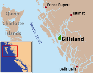
Gil Island is an island on the North Coast of British Columbia, Canada, located on the west side of Whale Channel in the entrance to Douglas Channel, one of the main coastal inlets, on the route of the Inside Passage between Pitt Island and Princess Royal Island. It is 26 km (16 mi) long, with a width ranging from 6 to 13 km, and an area of 231 km2. The only named summit on the mountainous island is Mount Gil, which faces the opening of Douglas Channel.

<span class="mw-page-title-main">Loch Inver</span> Sea Loch in grid reference NC

Loch Inver is a 3.62-kilometre-long sea loch in Assynt, Sutherland and is on the northwest coast of Scotland. The loch meets the coastal embayment of Enard Bay at the north end and The Minch, where it meets Soyea Island at its mouth.

<span class="mw-page-title-main">Kirkibost</span>

Kirkibost is a low-lying island west of North Uist in the Outer Hebrides of Scotland.

<span class="mw-page-title-main">National Cycle Route 76</span> Cycle route in the United Kingdom

National Cycle Network (NCN) Route 76 is a Sustrans National Route that runs from Berwick-upon-Tweed to Kirkcaldy. The route is 168 miles (270 km) in length and is fully open and signed in both directions. Between Dunbar and Kirkcaldy the route is known as the Round the Forth.

The geography of the North Sea studies coastal and submarine features as well as the people who live on its coasts. It is bounded by the east coasts of England and Scotland to the west and the northern and central European mainland to the east and south, including Norway, Denmark, Germany, the Netherlands, Belgium, and France. In the south-west, beyond the Straits of Dover, the North Sea becomes the English Channel. In the east, it connects to the Baltic Sea via the Skagerrak and Kattegat, narrow straits that separate Denmark from Norway and Sweden respectively. In the north, it opens in a widening funnel shape to the Norwegian Sea, which lies in the very north-eastern part of the Atlantic.

Gribbell Island is an island on the North Coast of British Columbia, Canada, located on the east side of the entrance to Douglas Channel at Wright Sound. Gribble Island Indian Reserve No. 10 is on its west coast, between Verney Passage and Ursula Channel at 53°21′00″N129°08′00″W. The small Wimbledon Range is on the south side of the island, facing the northern extremities of Princess Royal Island to the south, at 53°21′00″N129°02′00″W

<span class="mw-page-title-main">Galmisdale</span> Human settlement in Scotland

Galmisdale is the main port of the island of Eigg, one of the Small Isles of the Inner Hebrides. It is in the Scottish council area of Highland.

<span class="mw-page-title-main">Sandaig Bay</span> A bay in Lochaber, Scotland

Sandaig Bay is a coastal embayment, on a chord of 2.04 kilometres, on a 194° orientation, located on the northwestern end of the sea loch, Loch Nevis, facing the Sound of Sleat. The bay is within the western end of the Knoydart peninsula, in the Lochaber district in the historical county of Inverness-shire on the north west coast of Scotland.

References

  1. Adam and Charles Black (Firm) (1881). Black's Tourist's Guide to Scotland. p. 111. Retrieved 7 May 2021.
  2. United States. Hydrographic Office (1925). British Islands Pilot. U.S. Government Printing Office. p. 99.
  3. 1 2 United States. Hydrographic Office (1925). British Islands Pilot. U.S. Government Printing Office. p. 98.
  4. "Whiting Bay". Visiting Scotland. Visit Scotland. Retrieved 30 May 2021.
  5. Groome, Francis Hindes (1882). Ordnance Gazetteer of Scotland: A Survey of Scottish Topography, Statistical, Biographical and Historical. Edinburgh: T. C. Jack. p. 79.
  6. "Balnakailly Bay". Gazetteer for Scotland. School of GeoSciences, University of Edinburgh and The Royal Scottish Geographical Society. Retrieved 25 April 2023.
  7. "Ettrick Bay". Gazetteer for Scotland. School of GeoSciences, University of Edinburgh and The Royal Scottish Geographical Society. Retrieved 20 April 2017.
  8. Murphy, Alan (10 April 2014). Scotland Highlands & Islands Footprint Handbook. Footprint Travel Guides. p. 72. ISBN   978-1-909268-62-3.
  9. United States. Naval Oceanographic Office. Sailing Directions for the West Coast of Scotland, Mull of Galloway to Cape Wrath, Including Hebrides. p. 48.
  10. "Bell Bay". Gazetteer for Scotland. School of GeoSciences, University of Edinburgh and The Royal Scottish Geographical Society. Retrieved 25 April 2023.
  11. "Fintray Bay". Gazetteer for Scotland. School of GeoSciences, University of Edinburgh and The Royal Scottish Geographical Society. Retrieved 25 April 2023.
  12. Great Britain. Hydrographic Department (1886). West Coast of Scotland Pilot. J. D. Potter. p. 287.
  13. Clyde Cruising Club (24 April 2020). Firth of Clyde: Including Solway Firth and North Channel. Imray, Laurie, Norie and Wilson Ltd. p. 35. ISBN   978-1-78679-165-8.
  14. "Skate Bay". Gazetteer for Scotland. School of GeoSciences, University of Edinburgh and The Royal Scottish Geographical Society. Retrieved 25 April 2023.
  15. Transactions of the Glasgow Archaeological Society. Society. 1883. p. 175.
  16. "White Bay". Gazetteer for Scotland. School of GeoSciences, University of Edinburgh and The Royal Scottish Geographical Society. Retrieved 25 April 2023.
  17. "Wine Bay". Gazetteer for Scotland. School of GeoSciences, University of Edinburgh and The Royal Scottish Geographical Society. Retrieved 25 April 2023.