List of bridges in Ottawa

Last updated

This is a list of bridges in Ottawa, Ontario, Canada. They are listed from west to east and north to south. Bridges spanning Airport Parkway, the Confederation Line, Green's Creek, Highway 174, Highway 416, Highway 417, the Jock River, the Transitway, and the Trillium Line are not listed.

Contents

Spanning the Ottawa River

BridgeCarriesLengthBuiltCoordinatesImageRemarks
Morris Island Train BridgePedestrian pathway498 m1915 45°27′59.26″N76°17′10.57″W / 45.4664611°N 76.2862694°W / 45.4664611; -76.2862694 Originally carried Canadian Northern Railway (1915—1998) and the Ottawa Central Railway (1998—2008).

Converted into a pedestrian bridge in 2014.

Fitted to accommodate snowmobiles in 2022. [1]
Champlain Bridge Place Samuel-De Champlain

Island Park Drive
1010 m1928 45°24′35.5″N75°45′34.7″W / 45.409861°N 75.759639°W / 45.409861; -75.759639 Champlain Bridge Ottawa-Aylmer.JPG Crosses Bate Island, Cunningham Island, and Riopelle Island.

Longest bridge in Ottawa.
Lemieux Island BridgeOnigam Street215 m1919 45°24′50.1″N75°43′52.23″W / 45.413917°N 75.7311750°W / 45.413917; -75.7311750 Ottawa, Ontario - Lemieux Island Bridge - 3.jpg Crosses Bell Island.
Chief William Commanda Bridge Pedestrian pathway992 m1880 45°24′46.28″N75°43′33.76″W / 45.4128556°N 75.7260444°W / 45.4128556; -75.7260444 Ottawa rail bridge.JPG Crosses Lemieux Island.

Originally carried the Quebec, Montreal, Ottawa and Occidental Railway (1880—1882) and the Canadian Pacific Railway (1882—2005).

Converted into a pedestrian bridge in 2023.
Chaudière Bridge Chaudière Crossing99 m1919 45°25′16″N75°43′07″W / 45.42111°N 75.71861°W / 45.42111; -75.71861 Chaudiere Bridge 2013.jpg Site of the first bridge linking Ottawa and Gatineau.
Portage Bridge 700 m1973 45°25′20″N75°42′49″W / 45.42222°N 75.71361°W / 45.42222; -75.71361 Portage Bridge Ottawa-Hull.JPG Crosses Victoria Island.
Alexandra Bridge 563 m1900 45°25′47.81″N75°42′13.54″W / 45.4299472°N 75.7037611°W / 45.4299472; -75.7037611 Alexandra Bridge2.JPG Originally carried the Canadian Pacific Railway (1900—1966).
Macdonald-Cartier Bridge Autoroute 5 618 m1963 45°26′12″N75°42′9″W / 45.43667°N 75.70250°W / 45.43667; -75.70250 Macdonald-Cartier Bridge.JPG

Spanning the Rideau River

BridgeCarriesLengthBuiltCoordinatesImageRemarks
Bytown Bridge (West Bridge) Sussex Drive 70 m2005 45°26′21.88″N75°41′45.51″W / 45.4394111°N 75.6959750°W / 45.4394111; -75.6959750 Replaced the original bridge built in 1954.
Bytown Bridge (East Bridge) Sussex Drive 84 m2005 45°26′28.23″N75°41′41.31″W / 45.4411750°N 75.6948083°W / 45.4411750; -75.6948083 BytownPanoramic.750pix.jpg Replaced the original bridge built in 1954.
Minto Bridge (West Bridge) Union Street61 m 1900 45°26′17.68″N75°41′35.42″W / 45.4382444°N 75.6931722°W / 45.4382444; -75.6931722 Union street bridge ottawa.jpeg
Minto Bridge (East Bridge) Union Street112 m1900 45°26′22.93″N75°41′31.84″W / 45.4397028°N 75.6921778°W / 45.4397028; -75.6921778 Minto Bridge, Ottawa (45125919514).jpg Crosses Maple Island.
Island Lodge Road92 m1964 45°26′12.52″N75°40′55.62″W / 45.4368111°N 75.6821167°W / 45.4368111; -75.6821167
Porter Island BridgePedestrian pathway (closed)78 m1894 45°26′12.4″N75°40′50.48″W / 45.436778°N 75.6806889°W / 45.436778; -75.6806889
St. Patrick Street BridgeSt. Patrick Street163 m1975 45°26′15.03″N75°40′43.08″W / 45.4375083°N 75.6786333°W / 45.4375083; -75.6786333
Cummings Bridge Rideau Street 213 m1921 45°25′59.58″N75°40′16.59″W / 45.4332167°N 75.6712750°W / 45.4332167; -75.6712750 RideauRV.JPG
Adàwe Crossing Pedestrian pathway125 m2015 45°25′34.85″N75°40′12.51″W / 45.4263472°N 75.6701417°W / 45.4263472; -75.6701417 Adawe Crossing, Ottawa, view looking north, March 2016.jpg
Provincial Constable J. Robert Maki Bridge Highway 417 159 m1955 45°25′1.19″N75°39′46.48″W / 45.4169972°N 75.6629111°W / 45.4169972; -75.6629111
Rideau River Pedestrian/Cycling BridgePedestrian pathway160 m1909 45°24′58.86″N75°39′46.38″W / 45.4163500°N 75.6628833°W / 45.4163500; -75.6628833 Originally carried the Canadian National Railway (1909—1966).

Converted into a pedestrian bridge in 1970. [2]
Hurdman Bridge Confederation Line 159 m1983 45°24′51.18″N75°40′7.05″W / 45.4142167°N 75.6686250°W / 45.4142167; -75.6686250 Hurdman - 23.jpg Originally carried the Transitway. [3]
George McIlraith Bridge Smyth Road 240 m1965 45°23′58.69″N75°40′15.3″W / 45.3996361°N 75.670917°W / 45.3996361; -75.670917 George McIlraith Bridge.JPG [4]
Billings Bridge Bank Street 140 m1916 45°23′21.41″N75°40′40.53″W / 45.3892806°N 75.6779250°W / 45.3892806; -75.6779250 Billings Bridge.jpg
George Dunbar Bridge Bronson Avenue 268 m1996 45°22′59.79″N75°41′19.56″W / 45.3832750°N 75.6887667°W / 45.3832750; -75.6887667 George Dunbar Bridge Ottawa.jpg Replaced the original bridge built in 1955.
Rideau River Bridge Trillium Line 100 m1914 45°22′55.03″N75°41′41.81″W / 45.3819528°N 75.6949472°W / 45.3819528; -75.6949472 Trillium Line across Rideau River, Ottawa, Aug 2017,.jpg Originally carried the Canadian Pacific Railway (1914—2001).
Heron Road Workers Memorial Bridge Heron Road 276 m1967 45°22′33.01″N75°41′59.54″W / 45.3758361°N 75.6998722°W / 45.3758361; -75.6998722 Heron Road Bridge.JPG Also spans the Rideau Canal.
Hog's Back Fixed Bridge Hog's Back Road 69 m1977 45°22′14.94″N75°41′47.42″W / 45.3708167°N 75.6965056°W / 45.3708167; -75.6965056
Canadian Northern Ontario Railway Bridge Canadian National Railway 138 m1913 45°20′44.39″N75°41′52.09″W / 45.3456639°N 75.6978028°W / 45.3456639; -75.6978028 CNOR Bridge.jpg Originally carried the Canadian Northern Railway (1913—1923).
Michael J. E. Sheflin Bridge Hunt Club Road 230 m1985 45°20′2.86″N75°41′46.51″W / 45.3341278°N 75.6962528°W / 45.3341278; -75.6962528 Michael J. E. Sheflin Bridge.jpg
Vimy Memorial Bridge Strandherd Drive 144 m2014 45°16′11.89″N75°42′9.34″W / 45.2699694°N 75.7025944°W / 45.2699694; -75.7025944 Ottawa, Ontario - Vimy Memorial Bridge.jpg
Nicolls Island Road22 m1903 45°15′1.95″N75°42′7.08″W / 45.2505417°N 75.7019667°W / 45.2505417; -75.7019667 The bridge structure which originally spanned the Rideau Canal was moved to Nicolls Island in 1935. [5]
Long Island DamCecil Rowat Lane48 m1920 45°14′56.94″N75°42′11.52″W / 45.2491500°N 75.7032000°W / 45.2491500; -75.7032000
Bridge Street (West Bridge)Bridge Street85 m1956 45°13′41.57″N75°41′1.07″W / 45.2282139°N 75.6836306°W / 45.2282139; -75.6836306
Bridge Street (East Bridge)Bridge Street108 m1958 45°13′54.87″N75°40′47.03″W / 45.2319083°N 75.6797306°W / 45.2319083; -75.6797306
Watson's Mill Dam Pedestrian pathway60m1956 45°13′37.39″N75°40′56.68″W / 45.2270528°N 75.6824111°W / 45.2270528; -75.6824111 Watson's Mill (32385658048).jpg Replaced the original dam built in 1856. [6] [7]
Roger Stevens Drive174 m1961 45°9′42.92″N75°38′2.34″W / 45.1619222°N 75.6339833°W / 45.1619222; -75.6339833
Constable Hiram O'Callaghan Memorial Bridge Highway 416 290 m1996 45°4′57.89″N75°38′17.39″W / 45.0827472°N 75.6381639°W / 45.0827472; -75.6381639
Beckett's Landing BridgeMerlyn Wilson Road143 m1991 45°2′50.73″N75°40′48.24″W / 45.0474250°N 75.6800667°W / 45.0474250; -75.6800667 Replaced the original bridge built in 1937. [8]

Spanning the Rideau Canal

BridgeCarriesLengthBuiltCoordinatesImageRemarks
Plaza Bridge Wellington Street

Rideau Street

Elgin Street
65 m1912 45°25′28.86″N75°41′41.33″W / 45.4246833°N 75.6948139°W / 45.4246833; -75.6948139 Canal Rideau - 90.jpg Replaced Sappers Bridge and Dufferin Bridge.
Mackenzie King Bridge 101 m1951 45°25′24.35″N75°41′28.63″W / 45.4234306°N 75.6912861°W / 45.4234306; -75.6912861 Mackenzie King bridge.JPG
Laurier Avenue Bridge Laurier Avenue 91 m1900 45°25′21.35″N75°41′21.11″W / 45.4225972°N 75.6891972°W / 45.4225972; -75.6891972 Laurier Avenue Bridge.JPG
Corktown Footbridge Pedestrian pathway70 m2006 45°25′13.98″N75°41′4.42″W / 45.4205500°N 75.6845611°W / 45.4205500; -75.6845611 PedestrianBridge.JPG
Highway 417 122 m1965 45°24′44.43″N75°41′0.27″W / 45.4123417°N 75.6834083°W / 45.4123417; -75.6834083 Canal Rideau - 028.jpg
Pretoria Bridge Hawthorne Avenue58 m1915 45°24′41.58″N75°40′59.91″W / 45.4115500°N 75.6833083°W / 45.4115500; -75.6833083 Pont Pretoria - 08.jpg
Flora Footbridge Pedestrian pathway125 m2019 45°24′18.46″N75°40′51.87″W / 45.4051278°N 75.6810750°W / 45.4051278; -75.6810750 FloraFootbridgeOttawaSept29-2019.jpg
Bank Street Bridge Bank Street 112 m1912 45°23′46.72″N75°41′4.42″W / 45.3963111°N 75.6845611°W / 45.3963111; -75.6845611 Bank Street Bridge 2014 p2.jpg
Bronson Avenue Bridge Bronson Avenue 88 m1959 45°23′38.48″N75°41′45.97″W / 45.3940222°N 75.6961028°W / 45.3940222; -75.6961028 Skating on the Rideau canal in Ottawa.jpg
Heron Road Workers Memorial Bridge Heron Road 276 m1967 45°22′32.16″N75°42′7.93″W / 45.3756000°N 75.7022028°W / 45.3756000; -75.7022028 Heron Road Bridge.JPG Also spans the Rideau River.
Hog's Back Swing Bridge Hog's Back Road 27 m1976 45°22′11.26″N75°41′54.96″W / 45.3697944°N 75.6986000°W / 45.3697944; -75.6986000 Hog's Back Bridge.JPG

Spanning Patterson Creek (Ottawa)

BridgeCarriesLengthBuiltCoordinatesImageRemarks
O'Connor Street Bridge O'Connor Street 12 m1907 45°24′24.48″N75°41′10.76″W / 45.4068000°N 75.6863222°W / 45.4068000; -75.6863222 OConnorBridge-Ottawa.JPG
Queen Elizabeth Driveway Bridge Queen Elizabeth Driveway 10 mc. 1912 45°24′28.92″N75°40′55.4″W / 45.4080333°N 75.682056°W / 45.4080333; -75.682056 Rideau Canal, Ottawa - panoramio (7).jpg

Spanning Nepean Inlet

BridgeCarriesLengthBuiltCoordinatesImageRemarks
Nepean Bay Bridge Trans Canada Trail 30 m2005 45°24′49.52″N75°43′11.32″W / 45.4137556°N 75.7198111°W / 45.4137556; -75.7198111 Spans Nepean Bay.
LeBreton Bridge Kichi Zibi Mikan 66 m2005 45°24′50.04″N75°43′9.47″W / 45.4139000°N 75.7192972°W / 45.4139000; -75.7192972 Spans Nepean Bay.
Booth Street BridgePedestrian pathway20 m1874 45°24′50.93″N75°42′48.37″W / 45.4141472°N 75.7134361°W / 45.4141472; -75.7134361 Spans the Fleet Street Aqueduct.

Originally carried Booth Street.
Pooley's Bridge Pedestrian pathway35 m1873 45°24′59.71″N75°42′38.93″W / 45.4165861°N 75.7108139°W / 45.4165861; -75.7108139 Pooley s Bridge.jpg Spans the Fleet Street Aqueduct.

Oldest bridge in Ottawa.

See also

Related Research Articles

Riverview is a neighbourhood in Ottawa, Ontario, Canada. It is southeast of the downtown adjacent to the Rideau River, its location on which is its namesake. The 2021 Census population of Riverview is 13,113.

<span class="mw-page-title-main">Riverside Drive (Ottawa)</span>

Riverside Drive is a major road in Ottawa, Ontario, Canada, that follows along the eastern bank of the Rideau River. Its northern terminus is at the Transitway/Via Rail underpass just south of the Queensway, and the road proceeds south to Limebank Road where it continues as River Road until the city limits. North of the Queensway, Riverside continues as Vanier Parkway, which travels through Vanier until Beechwood Avenue. The Vanier Parkway name is linked to the neighbourhood of Vanier, which was named for former Governor General of Canada Georges Vanier.

Russell Road is an arterial road in Eastern Ontario, Canada. It begins in Ottawa in the Riverview neighbourhood and runs eastward through the rural communities of Ramsayville, Carlsbad Springs and Bearbrook in Ottawa and through the Municipality of Clarence-Rockland, connecting the communities of Cheney and Bourget, ending at Boundary Road on the eastern border of Clarence Rockland. In Ottawa it is officially Ottawa Road #26, and in Clarence-Rockland as United Counties of Prescott and Russell County Road #2.

<span class="mw-page-title-main">Transitway (Ottawa)</span> Bus rapid transit system in Ottawa, Canada

The Transitway is a bus rapid transit (BRT) network operated by OC Transpo in Ottawa, Ontario, Canada. It comprises a series of bus-only roadways and reserved lanes on city streets and highways. The dedicated busways ensure that buses and emergency vehicles on the Transitway rarely intersect directly with the regular traffic, and make it possible for them to continue at full speed even during rush hour. OC Transpo operates a network of rapid routes which use the Transitway to connect communities with the O-Train light rail system. Additional bus routes also use segments of the Transitway.

<span class="mw-page-title-main">Orleans, Ontario</span> Suburb of Ottawa, Ontario, Canada

Orleans is a community in Ottawa, Ontario, Canada. It is located in the east end of the city along the Ottawa River, about 16 km (10 mi) from Downtown Ottawa. The Canada 2021 Census determined that Orléans' population was 125,937. Prior to being amalgamated into Ottawa in 2001, the community of Orléans was spread over two municipal jurisdictions, the eastern portion being in the pre-amalgamation City of Cumberland, the western portion in the City of Gloucester. According to the 2021 census, 75,453 people lived in the Cumberland portion of Orleans, while 50,484 people lived in the Gloucester portion. Today, Orléans spans the municipal wards of Orléans East-Cumberland, Orléans West-Innes, and Orléans South-Navan. Orléans contains a significant francophone population.

King's Highway 417, commonly referred to as Highway 417 and as the Queensway through Ottawa, is a 400-series highway in the Canadian province of Ontario. It connects Ottawa with Montreal via A-40, and is the backbone of the highway system in the National Capital Region. Within Ottawa, it forms part of the Queensway west from Highway 7 to Ottawa Road 174. Highway 417 extends from the Quebec border, near Hawkesbury, to Arnprior, where it continues westward as Highway 17. Aside from the urban section through Ottawa, Highway 417 passes through farmland that dominates much of the fertile Ottawa Valley.

<span class="mw-page-title-main">Hurdman station</span> Mass transit station in Ottawa, Canada

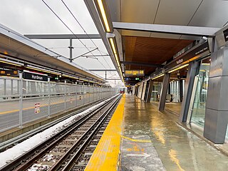
Hurdman is a station on Ottawa's O-Train Confederation Line, and bus rapid transit (BRT) system, transitway.

The Bytown and Prescott Railway (B&PR) was a railway joining Ottawa with Prescott on the Saint Lawrence River. The company was incorporated in 1850, and the first train ran from Prescott into Bytown on Christmas Day, 1854. The 84 km railway, Ottawa's first to outside markets, was initially used to ship lumber collected on the Ottawa River for further shipping along the St. Lawrence to markets in the United States and Montreal.

<span class="mw-page-title-main">Manotick</span> Community in Ontario, Canada

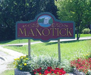
Manotick is a community in Rideau-Jock Ward in the rural south part of the City of Ottawa, Ontario, Canada. It is a suburb of the city, located on the Rideau River, immediately south of the suburbs Barrhaven and Riverside South, about 25 km (16 mi) from downtown Ottawa. It was founded by Moss Kent Dickinson in 1864. He named the village 'Manotick', after the Algonquin word for 'island'. It has been part of the City of Ottawa since amalgamation in 2001. Prior to that, it was located in Rideau Township. According to the Canada 2016 Census, Manotick had a population of 4,486.

The New York and Ottawa Railway was a railway connecting Tupper Lake in northeastern New York to Ottawa, Ontario, via Ramsayville, Russell, Embrun, Finch and Cornwall. It became part of the New York Central Railroad system in 1913, although it was under the larger company's possession since the end of 1904. It had started-out as the Northern Adirondack Railroad and evolved into the Northern New York Railroad, the New York and Ottawa Railroad, and was last known as the New York and Ottawa Railway before being merged into the New York Central and Hudson River Railroad. Other lines that were a part of this route are described below.

<span class="mw-page-title-main">Ottawa station</span> Main inter-city train station on the Via Rail Corridor in Ottawa, Ontario, Canada

Ottawa station, or Ottawa Train Station, is the main inter-city train station in Ottawa, Ontario, Canada, the capital of Canada. It is operated by Via Rail. It is located 4 kilometres (2.5 mi) east of downtown Ottawa and adjacent to Tremblay O-Train station in the neighbourhood of Eastway Gardens. The station serves inter-city trains connecting to Toronto, Kingston, Montreal and Quebec City on Via Rail's Corridor Route.

The Chief William Commanda Bridge, formerly the Prince of Wales Bridge, is a pedestrian/cycling bridge and former rail bridge that spans the Ottawa River between Ottawa, Ontario and Gatineau, Quebec, Canada. It connects the Trillium Pathway in Ottawa to the Voyageurs Pathway in Gatineau. The bridge crosses the south channel of the river to Lemieux Island at the edge of Nepean Bay and continues across the northern channel into the Province of Quebec.

<span class="mw-page-title-main">Nosbonsing and Nipissing Railway</span>

The Nosbonsing and Nipissing Railway (N&N) was a portage railway constructed by Ottawa lumber baron John Rudolphus Booth. The 5.5-mile (8.9 km) line connected Lake Nipissing with Lake Nosbonsing to allow lumber to be portaged onto the Mattawa River, and from there to the Ottawa River. It allowed timber from a wide area across central Ontario to be sent to Booth's mill in Ottawa, at that time the largest sawmill in the world.

The Ottawa, Arnprior and Parry Sound Railway, or OA&PS, is a historic railway that operated in central and eastern Ontario, Canada from 1897 until 1959. It was, for a time, the busiest railway route in Canada, carrying both timber and wood products from today's Algonquin Provincial Park areas, as well as up to 40% of the grain traffic from the Canadian west from Depot Harbour at Parry Sound through to the St. Lawrence River valley.

<span class="mw-page-title-main">Ottawa Road 174</span> Controlled-access highway in Ottawa

Ottawa Road 174, formerly Ottawa-Carleton Regional Road 174 and commonly referred to as Highway 174, is a city-maintained road in the City of Ottawa which serves the eastern suburbs of Orléans and Cumberland. The four-lane freeway segment between Highway 417/Aviation Parkway junction to Trim Road is also known as the Queensway, in addition the Queensway name continues to be applied to Highway 417 west of that intersection. Although the road continues through the towns of Rockland and Hawkesbury to the Quebec border, the portion east of the Ottawa city boundary is known as Prescott and Russell County Road 17.

<span class="mw-page-title-main">Canadian Northern Ontario Railway Federal Bridge</span> Bridge

The Canadian Northern Ontario Railway Bridge is a railway plate girder bridge over the Rideau River from the Merivale area to the Mooney's Bay neighbourhood in Ottawa, Ontario, Canada. It is owned today by the CNoR's successor Canadian National Railway, and amongst other services carries the Via Rail Toronto – Ottawa Corridor passenger trains.

Highway 17B was formerly the designation for six business routes of Highway 17, the main route of the Trans-Canada Highway through the Canadian province of Ontario. Each generally followed the original route of Highway 17 through the town or city that it served, and was subsequently given the Highway 17B designation when a newer bypass route was constructed to either reduce traffic pressure on the local street network, or provide a better thoroughfare that avoided urban areas altogether.

<span class="mw-page-title-main">Doon, Ontario</span> Suburban community in Kitchener, Ontario, Canada

Doon is a suburban community and former village which is now a part of the city of Kitchener, Ontario, Canada. Doon was settled around 1800 by German Mennonites from Pennsylvania, and after 1830 by Scottish immigrants. The area is located at the confluence of Schneider Creek and the Grand River. The post office was opened in 1845. A large flour mill, oatmeal mill, distillery and sawmill were built on the Doon River over the following years. The Perine brothers established extensive linen works and flax mills near the settlement. By 1870, there was a single church, Presbyterian, a variety of tradesmen and a population of 200.

<span class="mw-page-title-main">Whitney and Opeongo Railway</span>

The Whitney and Opeongo Railway (W&OR) was a logging railway in Ontario, Canada. It ran from Opeongo Lake to Whitney, where it connected to the Canada Atlantic Railway (CAR), running a total distance of about 14 miles (23 km). It opened in 1902 and closed in the 1920s with the end of major logging operations in the area.

References

  1. Churcher, Colin. "The Bridge over the Ottawa River at Fitzroy". Colin Churcher's Railway Pages.
  2. "Hurdman Train Bridge". Capital Gems.
  3. "History of Hurdman Station". Rail Fans.
  4. Elliott, Kim. "George McIlraith Bridge". Bridges of Ottawa.
  5. "Nicolls Island Road Bridge". Historic Bridges. Retrieved 30 March 2022.
  6. "History". Watson's Mill.
  7. "1900 – 1963". Watson's Mill.
  8. "The Rideau River Bridge on old Highway 16". The North Grenville Times.