List of cities in Algeria

Last updated

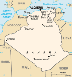
This is a list of Algerian cities and towns with more than 100,000 inhabitants, and towns and villages with more than 20,000 inhabitants. For a list of all the 1,541 municipalities (baladiyahs) of Algeria, see List of municipalities of Algeria, and for the postal code of an Algerian city, see list of postal codes of Algerian cities.

Contents

Map of Algeria Algeria CIA map.png
Map of Algeria
Algiers, Capital of Algeria Alger View Oct-2010 IMG 1039.JPG
Algiers, Capital of Algeria
Oran Oran facade maritime.JPG
Oran
Constantine Constantine, 1972.jpg
Constantine
Annaba Annaba.jpg
Annaba
Blida Blida houses.JPG
Blida

List of Algerian cities and towns with more than 100,000 inhabitants

List of Algerian cities and towns with 50,000-99,999 inhabitants

Contents : Top - A B C D E F G H I J K L M N O P Q R S T U V W X Y Z

A

B

C

E

F

G

H

K

L

M

O

R

S

T

See also

Related Research Articles

Algeria, since December 18, 2019, is divided into 58 wilayas (provinces). Prior to December 18, 2019, there were 48 provinces. The 58 provinces are divided into 1,541 baladiyahs (municipalities). The name of a province is always that of its capital city.

<span class="mw-page-title-main">Batna Province</span> Province of Algeria

Batna Province is a province of Algeria, in the region of Aurès. The capital is Batna. Localities in this province include N'Gaous, Merouana and Timgad. Belezma National Park is in the Belezma Range area of the province.

<span class="mw-page-title-main">Sétif Province</span> Province of Algeria

Sétif Province is a province (wilaya) in north-eastern Algeria. Its capital and largest city is Sétif; the next largest city is El Eulma. There is also the World Heritage Site of Djémila there.

<span class="mw-page-title-main">Laghouat Province</span> Province of Algeria

Laghouat is one of the fifty-eight provinces (wilaya) of Algeria. It is located in the north central part of Algeria. The province borders Tiaret Province to the north, El Bayadh Province to the west, Ghardaia Province to the south and Djelfa Province to the east. The capital of the province is Laghouat City. The province is famous for palm trees and livestock.

<span class="mw-page-title-main">Aïn Témouchent Province</span> Province of Algeria

Aïn Témouchent is a province (wilaya) in northwestern Algeria, named after its capital: Aïn Témouchent.

<span class="mw-page-title-main">Mascara Province</span> Province of Algeria

Mascara is a province (wilaya) in Algeria. It was named after its capital, whose name is Arabic for "military garrison". It is unsure whether the place is related to "mascara", the cosmetic. Another important locality is the town of Sig.

<span class="mw-page-title-main">Bordj Bou Arréridj Province</span> Province of Algeria

Bordj Bou ArréridjProvince is a province (wilaya) in northern Algeria around 200 km from the capital Algiers. It is considered as a crossroads between the east and west, the north and south.

<span class="mw-page-title-main">Biskra Province</span> Province of Algeria

Biskra is a province (wilaya) of Algeria. Its capital is Biskra. It is located on the northern edge of the Algerian Sahara, south of the Atlas Mountains.

<span class="mw-page-title-main">Bouïra Province</span> Province of Algeria

Bouïra is a province (wilaya) in the Kabylie region in Algeria.

<span class="mw-page-title-main">Chlef Province</span> Province of Algeria

Chlef is a province (wilaya) in Algeria. Its capital and biggest city is Chlef. It is the 8th most populous province in the country, having just over 1 million inhabitants.

<span class="mw-page-title-main">Médéa Province</span> Province of Algeria

Médéa is a province (wilaya) of Algeria. The capital is Médéa.

<span class="mw-page-title-main">Oum El Bouaghi Province</span> Province of Algeria

Oum El Bouaghi or Oum el-Bouaghi is a province (wilaya) of Algeria in the Aures region. The capital is Oum el-Bouaghi, which was named Can Robert, Sidi R'Ghis a few years later, and Oum El Bouaghi before independence.

<span class="mw-page-title-main">Relizane Province</span> Province of Algeria

Relizane is a province (wilaya) of Algeria. Relizane is the capital. Other localities include Bendaoud, Bouzegza, Hamri, Kalaa, Mazouna and Zemmoura. The Wilaya of Relizane massacres of 4 January 1998 happened in Relizane.

<span class="mw-page-title-main">Tiaret Province</span> Province of Algeria

Tiaret is a province (wilaya) of Algeria. The capital is Tiaret.

<span class="mw-page-title-main">Tlemcen Province</span> Province of Algeria

Tlemcen is a province (wilaya) in northwestern Algeria. The Tlemcen National Park is located there.

<span class="mw-page-title-main">Tiout, Algeria</span> Municipality in Naâma, Algeria

Tiout is a municipality in Naâma Province, Algeria. It is part of the district of Aïn Séfra and has a population of 3,161, which gives it 11 seats in the PMA. Its postal code is 45210 and its municipal code is 4504.

Moghrar is a municipality in Naâma Province, Algeria. It is the district seat the Moghrar District and has a population of 2,796, which gives it 11 seats in the PMA. Its municipal code is 4506

Aïn El Berd is a commune (baladiyah) in the Aïn El Berd district (daïra) in the Sidi Bel Abbès province (wilayah) of Algeria. It is situated in the northwestern part of the country, in the Hauts Plateaux region, and has a typical Mediterranean climate. Established as an official commune on April 15, 1886, Aïn El Berd is known for its beautiful countryside views and sites, as well as for its vineyards, olive trees, and wheat products. During the French colonial era, the surrounding areas, then called Saint-Marc and Saint-Henri, gave wines of good quality, and in 1889 and 1900 won silver and gold medals, respectively.

Ouled Rafaa is a village in the commune of Ouled Khoudir, in Ouled Khoudir District, Béchar Province, Algeria. The village is located on the northeast bank of the Oued Saoura 3 kilometres (1.9 mi) east of Ouled Khoudir. It is connected to Ouled Khoudir by a local road along the side of the river, along with the other village of El Ksar.

El Ksar is a village in the commune of Ouled Khoudir, in Ouled Khoudir District, Béchar Province, Algeria. The village is located on the east bank of the Oued Saoura 5 kilometres (3.1 mi) southeast of Ouled Khoudir. It is connected to Ouled Khoudir by a local road along the side of the river, along with the other village of Ouled Rafaa.

References

  1. "Algeria: Provinces & Major Cities - Population Statistics in Maps and Charts". City Population.