List of cities in Balochistan, Pakistan by population

Last updated

This is a list showing the most populous cities in the province of Balochistan, Pakistan as of the 2017 Census of Pakistan. In the following table, you can find each of the 54 cities and towns in the province with populations higher than 10,000 as of March 15, 2017. City populations found in this list only refer to populations found within the city's defined limits and any adjacent cantonments. The census totals below come from the Pakistan Bureau of Statistics. [1]

Contents

List

Quetta Quetta at night 2.jpg
Quetta
Turbat Meerani Dam Turbat Balochistan.jpg
Turbat
Khuzdar Khuzdar - panoramio.jpg
Khuzdar
Hub, Balochistan Gadani Beach, Hub, Balochistan, Pakistan.jpg
Hub, Balochistan
Chaman Chaman City.jpg
Chaman
Gwadar Gwadar city, the doors of Air.jpg
Gwadar
RankCity Name District Division Population
(2017) [2] [1]
Population
(1998) [3]
Average Annual
Population Growth Rate
(1998 - 2017)
Ref. (2017)
1 Quetta Quetta Quetta 1,001,205565,1373.05% Increase2.svg [4]
2 Turbat Kech Makran 213,55768,6036.15% Increase2.svg [5]
3 Khuzdar Khuzdar Qalat 182,92791,0573.73% Increase2.svg [6]
4 Hub Hub Qalat 175,37662,7635.54% Increase2.svg [7]
5 Chaman Chaman District Quetta 123,19156,7924.15% Increase2.svg [8]
6 Dera Murad Jamali Nasirabad Nasirabad 96,59138,3414.96% Increase2.svg [9]
7 Gwadar Gwadar Makran 90,76245,0213.75% Increase2.svg [10]
8 Dera Allah Yar Jaffarabad Nasirabad 80,90838,3714.00% Increase2.svg [11]
9 Usta Mohammad Jaffarabad Nasirabad 77,09738,9463.65% Increase2.svg [11]
10 Sui Town Dera Bugti Sibi 71,676N/A A N/A A [12]
11 Sibi Sibi Sibi 64,42748,4671.51% Increase2.svg [13]
12 Loralai Loralai Zhob 54,75829,8753.23% Increase2.svg [14]
13Tump Kech Makran 48,766N/A A N/A A [5]
14 Nushki Nushki Rakhshan 46,38623,9483.53% Increase2.svg [15]
15 Zhob Zhob Zhob 46,24843,8430.28% Increase2.svg [16]
16 Kharan Kharan Rakhshan 156,15227,8062.52% Increase2.svg [17]
17Chitkan Panjgur Makran 44,43421,2973.94% Increase2.svg [18]
18 Khanozai Pishin Quetta 40,238N/A A N/A A [19]
19 Buleda Kech Makran 39,813N/A A N/A A [5]
20Saranan Pishin Quetta 37,927N/A A N/A A [19]
21Zehri Khuzdar Qalat 37,85413,1435.71% Increase2.svg [6]
22 Qalat Qalat Qalat 36,86422,6462.59% Increase2.svg [20]
23Tasp Panjgur Makran 35,890N/A A N/A A [18]
24 Surab Shaheed Sikandarabad Qalat 35,59411,1486.29% Increase2.svg [20]
25 Pishin Pishin Quetta 35,57722,9552.33% Increase2.svg [19]

Panjgur the land of dates


26 Mastung Sibi Qalat 35,12924,1311.99% Increase2.svg [21]
27 Qilla Saifullah Qilla Saifullah Zhob 34,6778,1297.92% Increase2.svg [22]
28 Pasni Gwadar Makran 34,52429,5380.82% Increase2.svg [10]
29 Nal Khuzdar Qalat 33,299N/A A N/A A [6]
30Winder Lasbela Qalat 29,59811,5695.06% Increase2.svg [7]
31 Uthal Lasbela Qalat 29,41413,3194.25% Increase2.svg [7]
32 Huramzai Pishin Quetta 29,400N/A A N/A A [19]
33 Muslim Bagh Qilla Saifullah Zhob 28,06617,1702.61% Increase2.svg [22]
34Dera Bugti Dera Bugti Sibi 27,62515,4953.08% Increase2.svg [12]
35Qilla Abdullah Qila Abdullah Quetta 26,151N/A A N/A A [8]
36 Bela Lasbela Qalat 24,31816,7051.99% Increase2.svg [7]
37 Wadh Khuzdar Qalat 23,05613,7942.73% Increase2.svg [6]
38 Washuk Washuk Rakhshan 21,872N/A A N/A A [23]
39 Awaran Awaran Qalat 21,848N/A A N/A A [24]
40 Machh Kachhi Nasirabad 19,15214,4881.48% Increase2.svg [25]
41 Jiwani Gwadar Makran 18,53314,0721.46% Increase2.svg [10]
42 Ormara Gwadar Makran 17,78011,5212.30% Increase2.svg [10]
43 Kohlu Kohlu Sibi 17,4269,6652.46% Increase2.svg [26]
44 Bhag Sibi Sibi 16,60812,1811.64% Increase2.svg [27]
45 Dalbandin Chagai Rakhshan 16,31911,9481.65% Increase2.svg [28]
46 Dhadar Kachhi Nasirabad 15,28012,8180.93% Increase2.svg [25]
47Musakhel Musakhel Zhob 14,13811,5891.05% Increase2.svg [29]
48 Harnai Harnai Sibi 13,2979,3591.86% Increase2.svg [30]
49 Dureji Lasbela Qalat 12,871N/A A N/A A [7]
50 Sohbatpur Sohbatpur Nasirabad 12,8678,2062.39% Increase2.svg [31]
51Gajjar Mashkay Awaran Qalat 12,493N/A A N/A A [24]
52 Barkhan Barkhan Zhob 12,1767,6702.46% Increase2.svg [32]
53Shahrug Harnai Sibi 11,257N/A A N/A A [30]
54Duki Duki Zhob 10,1805,1093.69% Increase2.svg [14]

Notes

A. ^ This city did not exist as a municipality and was not classified as an urban area at the time of the 1998 Pakistan Census.

Related Research Articles

<span class="mw-page-title-main">Balochistan, Pakistan</span> Province of Pakistan

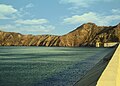
Balochistan is a province of Pakistan. Located in the southwestern region of the country, Balochistan is the largest province of Pakistan by land area but is the least populated one. It is bordered by the Pakistani provinces of Khyber Pakhtunkhwa to the north-east, Punjab to the east and Sindh to the south-east; shares international borders with Iran to the west and Afghanistan to the north; and is bound by the Arabian Sea to the south. Balochistan is an extensive plateau of rough terrain divided into basins by ranges of sufficient heights and ruggedness. It has the world's largest deep sea port, the Port of Gwadar lying in the Arabian Sea.

<span class="mw-page-title-main">Demographics of Pakistan</span>

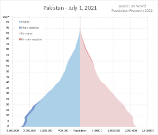
Pakistan had a population of 241,492,197 or 241.49 Million according to the final results of the 2023 Census. This figure includes Pakistan's four provinces e.g. Punjab, Sindh, KPK, Balochistan and Islamabad Capital Territory. AJK and Gilgit-Baltistan's census data is yet to be approved by CCI Council of Pakistan. Pakistan is the world's fifth most populous country.

<span class="mw-page-title-main">Swabi</span> City in Khyber Pakhtunkhwa, Pakistan

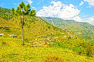
Swabi is a city in the Khyber Pakhtunkhwa province of Pakistan. It is located near the bank of the Indus River. It is the 73rd largest city of Pakistan and eighth largest in the province of Khyber Pakhtunkhwa. Swabi is also a major city in the Mardan Division, where it is the second-largest city.

<span class="mw-page-title-main">Parachinar</span> City in Khyber Pakhtunkhwa, Pakistan

Parachinar is a town and the capital of the Kurram District in the province of Khyber Pakhtunkhwa, Pakistan. It is mainly inhabited by Pashtun.

Hangu is a city in the Khyber Pakhtunkhwa province of Pakistan. It is the largest city and namesake of Hangu District and is the third-largest city in Kohat Division, after Karak and Kohat. In 1998, Hangu was the second-largest city in the division. Hangu is the 27th largest city in the province of Khyber Pakhtunkhwa. The principal language of the city is Pashto.

Mīrānshāh (Pashto: میران شاه) is a small town that is the administrative headquarters of North Waziristan District, Khyber Pakhtunkhwa province of Pakistan. Miranshah lies on the banks of the Tochi River in a wide valley surrounded by the foothills of the Hindu Kush mountains. It is located at an elevation of about 930 metres (3,050 ft), 17 kilometres (11 mi) from the Pakistan-Afghanistan border. The nearest city in Pakistan is Bannu, about 55 kilometres (34 mi) to the east, while the nearest city across the border in Afghanistan is Khost, 60 kilometres (37 mi) to the northwest.

<span class="mw-page-title-main">Kohat Division</span> Division in Khyber Pakhtunkhwa, Pakistan

Kohat Division is one of the seven divisions in the Khyber Pakhtunkhwa province of Pakistan. It consists of five districts: Hangu, Karak, Kohat, Kurram, and Orakzai. According to the 2017 Census of Pakistan, the division had a population of 3,211,458, making it the third-least populous division in the province. Its area is 12,377 km2 (4,779 sq mi). Thus, it is also the fourth-largest division by area in the province. Kohat is the division's largest city and its namesake. Kohat city has a population of 220,000. The division borders Bannu Division to the south and west, Peshawar Division to the north and east, the province of Punjab to the east, and Afghanistan to the northwest.

<span class="mw-page-title-main">Mardan Division</span> Division in Khyber Pakhtunkhwa, Pakistan

Mardan Division is one of the seven divisions in the Khyber Pakhtunkhwa province of Pakistan. It consists of two districts: Mardan and Swabi. According to the 2017 Pakistani Census, the division had a population of 3,997,667, making it the fourth-most populous division in the province. However, it only spans 3,175 km2 (1,226 sq mi) of area, which makes it the smallest division by area in the province as well. Mardan, with over 350,000 people, is the division's namesake and most populous city. The division borders Hazara Division, Malakand Division, and Peshawar Division. The division does not have a single public airport.

<span class="mw-page-title-main">Bannu Division</span> Division in Khyber Pakhtunkhwa, Pakistan

Bannu Division is one of seven divisions in Pakistan's Khyber Pakhtunkhwa province. It consists of three districts: Bannu, Lakki Marwat, and North Waziristan. According to the 2017 Pakistani Census, the division had a population of 2,656,801, making it the least populous division in the province, but it spans 9,975 km2 (3,851 sq mi) of area, and this makes it the third-smallest division by area in the province. Lakki Marwat is the largest city of Bannu Division, with around 60,000 people, while the division's namesake and second-largest city is Bannu, with just under 50,000 people. The division borders Dera Ismail Khan Division to the south and west, Kohat Division to the north and east, and the province of Punjab, Pakistan to its east.

<span class="mw-page-title-main">Karak, Pakistan</span> City in Khyber Pakhtunkhwa, Pakistan

Karak is the headquarters of Karak District in the Khyber Pakhtunkhwa province of Pakistan. It is 123 km from Peshawar on the main Indus Highway between Peshawar and Karachi. It is located at 33°7'12N 71°5'41E. Karak is said to be the single district in Pakistan that is inhabited by only one tribe of Pashtuns — the Khattaks.

Tordher is a town in the Swabi District of the Khyber Pakhtunkhwa province in Pakistan. It is the second leading trading city in the district, after Swabi. The town is located on rich, alluvial soil. It is situated near the rivers Kabul and Indus.

Sadda is a city in Kurram District in the Khyber Pakhtunkhwa province of Pakistan. Located on the Kurram River, it is a big trade market for the people of Lower Kurram and Central Kurram. The main tribe living in Sadda is the Bangash. Sadda is located about 50 kilometres (31 mi) southeast of Parachinar. The nearest main city on the Afghan side of the border is Khost, which is located about 70 kilometres (43 mi) to the southwest of Sadda.

Doaba is a small city located in Tall tehsil, Hangu district, Pakistan. Its population is just above 20,000, but the city has only 1,942 households. The most spoken language in Doaba is Pashto. It is roughly 30 kilometres (19 mi) from Hangu and roughly 15 kilometres (9.3 mi) from Thall. Doaba is Hangu district's third-largest city.

<span class="mw-page-title-main">Bannu Cantonment</span> Cantonment in Khyber Pakhtunkhwa, Pakistan

Bannu Cantonment is a cantonment adjacent to Bannu in Khyber Pakhtunkhwa, Pakistan. It is the only cantonment in Bannu District and also the only one in the Bannu Division. It has a population of 8,320.

Langay (لنگے) is a village in Gujarat District in Punjab province, Pakistan. According to 2017 Census of Pakistan, its population consists of 6,632 people which is mixture of Jatts and other castes with Jatts being in a ruling position.

<span class="mw-page-title-main">Washuk District</span> District of Balochistan in Pakistan

Washuk District is a district in Balochistan province of Pakistan. Washuk, the district headquarters, is located at the center of the district.

Sarai Naurang is a tehsil located in Lakki Marwat District, Khyber Pakhtunkhwa, Pakistan. The population is 296,908 according to the 2017 census. It is a mostly rural area, but it does contain one urban area, the town of Naurang, which has a population of 29,955. Naurang is the second-largest city in Lakki Marwat District and the third-largest in Bannu Division.

<span class="mw-page-title-main">Chaman District</span> District in Balochistan, Pakistan

Chaman District is an administrative district of Balochistan Province, Pakistan. Chaman District was created after bifurcating Qila Abdullah District.

References

  1. 1 2 "Block Wise Provisional Summary Results of 6th Population & Housing Census-2017 [As on January 03, 2018]". Block Wise Provisional Summary Results of 6th Population & Housing Census-2017 [As on January 03, 2018]. Pakistan Bureau of Statistics.
  2. "Balochistān (Pakistan): Province, Major Cities, Municipalites & Towns - Population Statistics, Maps, Charts, Weather and Web Information". www.citypopulation.de.
  3. "TABLE-1: AREA & POPULATION OF ADMINISTRATIVE UNITS BY RURAL/URBAN: 1951-1998 CENSUSES" (PDF). Administrative Units.pdf. Pakistan Bureau of Statistics. Archived (PDF) from the original on 20 June 2020. Retrieved 20 June 2020.
  4. "POPULATION AND HOUSEHOLD DETAIL FROM BLOCK TO DISTRICT LEVEL BALOCHISTAN (QUETTA DISTRICT)" (PDF). QUETTA_BLOCKWISE.pdf. Pakistan Bureau of Statistics. 3 January 2018. Archived from the original (PDF) on 25 June 2020. Retrieved 25 June 2020.
  5. 1 2 3 "POPULATION AND HOUSEHOLD DETAIL FROM BLOCK TO DISTRICT LEVEL BALOCHISTAN (KECH DISTRICT)" (PDF). KECH_BLOCKWISE.pdf. Pakistan Bureau of Statistics. 3 January 2018. Archived from the original (PDF) on 25 June 2020. Retrieved 25 June 2020.
  6. 1 2 3 4 "POPULATION AND HOUSEHOLD DETAIL FROM BLOCK TO DISTRICT LEVEL BALOCHISTAN (KHUZDAR DISTRICT)" (PDF). KHUZDAR_BLOCKWISE.pdf. Pakistan Bureau of Statistics. 3 January 2018. Archived from the original (PDF) on 25 June 2020. Retrieved 25 June 2020.
  7. 1 2 3 4 5 "POPULATION AND HOUSEHOLD DETAIL FROM BLOCK TO DISTRICT LEVEL BALOCHISTAN (LASBELA DISTRICT)" (PDF). LASBELA_BLOCKWISE.pdf. Pakistan Bureau of Statistics. 3 January 2018. Archived from the original (PDF) on 25 June 2020. Retrieved 25 June 2020.
  8. 1 2 "POPULATION AND HOUSEHOLD DETAIL FROM BLOCK TO DISTRICT LEVEL BALOCHISTAN (KILLA ABDULLAH DISTRICT)" (PDF). KILLLA ABDULLAH_BLOCKWISE.pdf. Pakistan Bureau of Statistics. 3 January 2018. Archived from the original (PDF) on 25 June 2020. Retrieved 25 June 2020.
  9. "POPULATION AND HOUSEHOLD DETAIL FROM BLOCK TO DISTRICT LEVEL BALOCHISTAN (NASIRABAD DISTRICT)" (PDF). NASIRABAD_BLOCKWISE.pdf. Pakistan Bureau of Statistics. 3 January 2018. Archived from the original (PDF) on 27 June 2020. Retrieved 27 June 2020.
  10. 1 2 3 4 "POPULATION AND HOUSEHOLD DETAIL FROM BLOCK TO DISTRICT LEVEL BALOCHISTAN (GWADAR DISTRICT)" (PDF). GWADAR_BLOCKWISE.pdf. Pakistan Bureau of Statistics. 3 January 2018. Archived from the original (PDF) on 25 June 2020. Retrieved 25 June 2020.
  11. 1 2 "POPULATION AND HOUSEHOLD DETAIL FROM BLOCK TO DISTRICT LEVEL BALOCHISTAN (JAFFARABAD DISTRICT)" (PDF). JAFFARABAD_BLOCKWISE.pdf. Pakistan Bureau of Statistics. 3 January 2018. Archived from the original (PDF) on 25 June 2020. Retrieved 25 June 2020.
  12. 1 2 "POPULATION AND HOUSEHOLD DETAIL FROM BLOCK TO DISTRICT LEVEL BALOCHISTAN (DERA BUGTI DISTRICT)" (PDF). DERA BUGTI_BLOCKWISE.pdf. Pakistan Bureau of Statistics. 3 January 2018. Archived from the original (PDF) on 25 June 2020. Retrieved 25 June 2020.
  13. "POPULATION AND HOUSEHOLD DETAIL FROM BLOCK TO DISTRICT LEVEL BALOCHISTAN (SIBI DISTRICT)" (PDF). SIBI_BLOCKWISE.pdf. Pakistan Bureau of Statistics. 3 January 2018. Archived from the original (PDF) on 29 June 2020. Retrieved 29 June 2020.
  14. 1 2 "POPULATION AND HOUSEHOLD DETAIL FROM BLOCK TO DISTRICT LEVEL BALOCHISTAN (LORALAI DISTRICT)" (PDF). LORALAI_BLOCKWISE.pdf. Pakistan Bureau of Statistics. 3 January 2018. Archived from the original (PDF) on 6 September 2020. Retrieved 6 September 2020.
  15. "POPULATION AND HOUSEHOLD DETAIL FROM BLOCK TO DISTRICT LEVEL BALOCHISTAN (NUSHKI DISTRICT)" (PDF). NUSHKI_BLOCKWISE.pdf. Pakistan Bureau of Statistics. 3 January 2018. Archived from the original (PDF) on 28 June 2020. Retrieved 28 June 2020.
  16. "POPULATION AND HOUSEHOLD DETAIL FROM BLOCK TO DISTRICT LEVEL BALOCHISTAN (ZHOB DISTRICT)" (PDF). ZHOB_BLOCKWISE.pdf. Pakistan Bureau of Statistics. 3 January 2018. Archived from the original (PDF) on 29 June 2020. Retrieved 29 June 2020.
  17. "POPULATION AND HOUSEHOLD DETAIL FROM BLOCK TO DISTRICT LEVEL BALOCHISTAN (KHARAN DISTRICT)" (PDF). KHARAN_BLOCKWISE.pdf. Pakistan Bureau of Statistics. 3 January 2018. Archived from the original (PDF) on 25 June 2020. Retrieved 25 June 2020.
  18. 1 2 "POPULATION AND HOUSEHOLD DETAIL FROM BLOCK TO DISTRICT LEVEL BALOCHISTAN (PANJGUR DISTRICT)" (PDF). PANJGUR_BLOCKWISE.pdf. Pakistan Bureau of Statistics. 3 January 2018. Archived from the original (PDF) on 28 June 2020. Retrieved 28 June 2020.
  19. 1 2 3 4 "POPULATION AND HOUSEHOLD DETAIL FROM BLOCK TO DISTRICT LEVEL BALOCHISTAN (PISHIN DISTRICT)" (PDF). PISHIN_BLOCKWISE.pdf. Pakistan Bureau of Statistics. 3 January 2018. Archived from the original (PDF) on 29 June 2020. Retrieved 29 June 2020.
  20. 1 2 "POPULATION AND HOUSEHOLD DETAIL FROM BLOCK TO DISTRICT LEVEL BALOCHISTAN (KALAT DISTRICT)" (PDF). KALAT_BLOCKWISE.pdf. Pakistan Bureau of Statistics. 3 January 2018. Archived from the original (PDF) on 25 June 2020. Retrieved 25 June 2020.
  21. "POPULATION AND HOUSEHOLD DETAIL FROM BLOCK TO DISTRICT LEVEL BALOCHISTAN (MASTUNG DISTRICT)" (PDF). MASTUNG_BLOCKWISE.pdf. Pakistan Bureau of Statistics. 3 January 2018. Archived from the original (PDF) on 27 June 2020. Retrieved 27 June 2020.
  22. 1 2 "POPULATION AND HOUSEHOLD DETAIL FROM BLOCK TO DISTRICT LEVEL BALOCHISTAN (KILLA SAIFULLAH DISTRICT)" (PDF). KILLLA SAIFULLAH_BLOCKWISE.pdf. Pakistan Bureau of Statistics. 3 January 2018. Archived from the original (PDF) on 25 June 2020. Retrieved 25 June 2020.
  23. "POPULATION AND HOUSEHOLD DETAIL FROM BLOCK TO DISTRICT LEVEL BALOCHISTAN (WASHUK DISTRICT)" (PDF). WASHUK_BLOCKWISE.pdf. Pakistan Bureau of Statistics. 3 January 2018. Archived from the original (PDF) on 29 June 2020. Retrieved 29 June 2020.
  24. 1 2 "POPULATION AND HOUSEHOLD DETAIL FROM BLOCK TO DISTRICT LEVEL BALOCHISTAN (AWARAN DISTRICT)" (PDF). AWARAN_BLOCKWISE.pdf. Pakistan Bureau of Statistics. 3 January 2018. Archived from the original (PDF) on 25 June 2020. Retrieved 25 June 2020.
  25. 1 2 "POPULATION AND HOUSEHOLD DETAIL FROM BLOCK TO DISTRICT LEVEL BALOCHISTAN (KACHHI DISTRICT)" (PDF). KACHHI_BLOCKWISE.pdf. Pakistan Bureau of Statistics. 3 January 2018. Archived from the original (PDF) on 25 June 2020. Retrieved 25 June 2020.
  26. "POPULATION AND HOUSEHOLD DETAIL FROM BLOCK TO DISTRICT LEVEL BALOCHISTAN (KOHLU DISTRICT)" (PDF). KOHLU_BLOCKWISE.pdf. Pakistan Bureau of Statistics. 3 January 2018. Archived from the original (PDF) on 25 June 2020. Retrieved 25 June 2020.
  27. "POPULATION AND HOUSEHOLD DETAIL FROM BLOCK TO DISTRICT LEVEL BALOCHISTAN (LEHRI DISTRICT)" (PDF). LEHRI_BLOCKWISE.pdf. Pakistan Bureau of Statistics. 3 January 2018. Archived from the original (PDF) on 27 June 2020. Retrieved 27 June 2020.
  28. "POPULATION AND HOUSEHOLD DETAIL FROM BLOCK TO DISTRICT LEVEL BALOCHISTAN (CHAGAI DISTRICT)" (PDF). CHAGAI_BLOCKWISE.pdf. Pakistan Bureau of Statistics. 3 January 2018. Archived from the original (PDF) on 25 June 2020. Retrieved 25 June 2020.
  29. "POPULATION AND HOUSEHOLD DETAIL FROM BLOCK TO DISTRICT LEVEL BALOCHISTAN (MUSAKHEL DISTRICT)" (PDF). MUSAKHEL_BLOCKWISE.pdf. Pakistan Bureau of Statistics. 3 January 2018. Archived from the original (PDF) on 27 June 2020. Retrieved 27 June 2020.
  30. 1 2 "POPULATION AND HOUSEHOLD DETAIL FROM BLOCK TO DISTRICT LEVEL BALOCHISTAN (HARNAI DISTRICT)" (PDF). HARNAI_BLOCKWISE.pdf. Pakistan Bureau of Statistics. 3 January 2018. Archived from the original (PDF) on 25 June 2020. Retrieved 25 June 2020.
  31. "POPULATION AND HOUSEHOLD DETAIL FROM BLOCK TO DISTRICT LEVEL BALOCHISTAN (SOHBATPUR DISTRICT)" (PDF). SOHBATPUR_BLOCKWISE.pdf. Pakistan Bureau of Statistics. 3 January 2018. Archived from the original (PDF) on 29 June 2020. Retrieved 29 June 2020.
  32. "POPULATION AND HOUSEHOLD DETAIL FROM BLOCK TO DISTRICT LEVEL BALOCHISTAN (BARKHAN DISTRICT)" (PDF). BARKHAN_BLOCKWISE.pdf. Pakistan Bureau of Statistics. 3 January 2018. Archived from the original (PDF) on 25 June 2020. Retrieved 25 June 2020.

See also