Karnataka, formerly Mysore State, is a state in the southwestern region of India. It was formed as Mysore State on 1 November 1956, with the passage of the States Reorganisation Act, and renamed Karnataka in 1973. The state was part of the Carnatic region in British terminology. Its capital and largest city is Bengaluru (Bangalore).

Mysore, officially Mysuru, is a metropolitan city in the southern Indian state of Karnataka. It is the state's third-most populous and is one of the cleanest cities in India according to Swachh Survekshan. It is the seat of the Wadiyar dynasty and was the capital of the Kingdom of Mysore for almost six centuries, from 1399 until 1947. It is currently the headquarters of Mysore district and Mysore division. Known for its heritage structures and palaces, including the famous Mysore Palace, and noted for its culture, Mysore is popularly known as the "City of Palaces", the "Heritage City", and the "Cultural Capital of Karnataka". For its pristine and calm ambience, it is also known as "Pensioners' Paradise".

Chamarajanagar or Chamarajanagara is the southernmost district in the state of Karnataka, India. It was carved out of the original larger Mysore District in 1998. Chamarajanagar town is the headquarters of this district.

Dharwad, also known as Dharwar, is a city located in the northwestern part of the Indian state of Karnataka. It is the headquarters of the Dharwad district of Karnataka and forms a contiguous urban area with the city of Hubballi. It was merged with Hubballi in 1962 to form the twin cities of Hubballi-Dharwad. It covers an area of 213 km2 (82 sq mi) and is located 430 km (270 mi) northwest of Bangalore, on NH-48, between Bangalore and Pune.

Tumakuru district is an administrative district in the state of Karnataka in India. It is the third largest district in Karnataka by land area with an area of 10,598 km2, and fourth largest by Population. It is a one-and-a-half-hour drive from Bengaluru, the state capital. The district is known for the production of coconuts and is also called as 'Kalpataru Nadu'. It is the only discontiguous district in Karnataka.

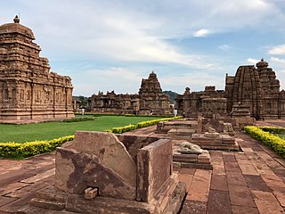
Bagalkot district, officially Bagalakote, is an administrative district in the Indian state of Karnataka. The district headquarters is located in the town of Bagalakote. The district is located in northern Karnataka and borders Belgaum, Gadag, Koppal, Raichur and Bijapur. The new Bagalakote district was carved out of Vijayapura in 1997 via Government of Karnataka directive Notification RD 42 LRD 87 Part III. The bifurcated Bagalkot district consists of ten taluks — Badami, Bagalakote, Bilagi, Guledgudda, Rabkavi Banhatti, Hunagund, Ilkal, Jamakhandi and Mudhol, Teradal.

Mysore district, officially Mysuru district, is an administrative district located in the southern part of the state of Karnataka, India. It is the administrative headquarters of Mysore division. Chamarajanagar District was carved out of the original larger Mysore District in the year 1998. The district is bounded by Chamrajanagar district to the southeast, Mandya district to the east and northeast, Kerala state to the south, Kodagu district to the west, and Hassan district to the north.

Belagavi district, formerly known as also Belgaum district, is a district in the state of Karnataka, India. The district is known as Sugar Bowl of Karnataka with 1.5 lakh (150,000) hectares being used for commercial production and it has displaced Mandya district in sugar cane production over the last decade. The city of Belgaum (Belagavi) is the district headquarters in Belagavi district. It houses the Second legislative building, where the Karnataka Legislature hold session once a year. The district is famous for its native sweet, Kunda. According to the 2011 Census of India, it has a population of 4,779,661, of which 24.03% live in urban areas, making it the second most populous district in Karnataka, after Bangalore Urban. The district has an area of 13,415 km2 (5,180 sq mi) making it the largest district in Karnataka, and is bounded by Kolhapur District and Sangli district of Maharashtra state on the west and north, on the northeast by Bijapur district, on the east by Bagalkot district, on the southeast by Gadag district, on the south by Dharwad and Uttara Kannada districts, and on the southwest by the state of Goa.

Bengaluru division is one of the four divisions of the Indian state Karnataka. The division comprises the districts of Bangalore Urban, Bangalore Rural, Chikkaballapur, Chitradurga, Davanagere, Kolar, Ramanagara, Shivamogga, and Tumakuru.The total area of the division is 49,936 sq.km. The total population as of 2011 census is 22,523,301, making it the world's fifth most populous sub-division.
Bangalore Rural district is one of the 31 districts in Karnataka, India. It was formed in 1986, when Bangalore District was divided into Bangalore Rural and Bangalore Urban. Presently in Bangalore Rural district, there are 4 talukas: Devanahalli, Nelamangala, Doddaballapura, Hoskote. It has 20 hoblies, 294 villages, 3 towns, 2 tier-three cities, administered by 66 Village Panchayats , 3Town Municipal Councils (Purasabes) and 2 City Municipal Councils (Nagarsabes).
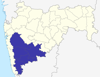
Pune Division is one of the six administrative divisions of the Indian State of Maharashtra. Pune Division is bound by Konkan Division to the west, Nashik Division to the north, Aurangabad Division to the east, and the state of Karnataka to the south.

Kalaburagi district, formerly known as Gulbarga district, is one of the 31 districts of Karnataka state in southern India. Kalaburagi city is the administrative headquarters of the district. The district is the headquarters of Kalaburagi division.
Mahalingpur or Mahalingapura in Kannada is a town of Bagalkot district in the Indian state of Karnataka. Agriculture, weaving and jaggery production are the primary industries here. In the past, town was called as Naragatti. Later renamed as Mahalingpur after the gracious appearance of Lord Shri Mahalingeshwara. People speak typical Kannada, understand English and Hindi. The town is known for its picturesque surroundings and pleasant climate. The Ghataprabha River flows through nearby Nandagaon village from its source, which lies to the southwest of the town, and in Kudala Sangama gets merge with Krishna. Mahalingpur is one of the major commercial towns in the Bagalkot district. Jaggery and Saari's are common export marketing stuffs here.
Karnataka, with a total population of 61,100,000, is one of the major states in South India. Kannada is the official language of Karnataka. Other linguistic minorities in the state are Tulu, Kodava, Konkani and Urdu. Karnataka is also in the forefront of population control measures with the world's first two birth control clinics being set up in 1930 in the Mandya district.
Gothe village is located in Jamakhandi taluka of Bagalkot district in Karnataka, India. It is situated 37 km away from sub-district headquarter Jamakhandi and 117 km away from district headquarter Bagalkot. Vijayapura is the nearest city to Gothe which is approximately 36 km away.
Inchal is a village in the southern state of Karnataka, India. It is located in the Saundatti taluk of Belgaum district in Karnataka.
Tamil Nadu is one of the 28 states of India. Its capital and largest city is Chennai. Tamil Nadu lies in the southernmost part of the Indian Peninsula and is bordered by the States of Puducherry, Kerala, Karnataka and Andhra Pradesh. It is the tenth-largest state in India and the seventh most populous state.

Bangalore, officially Bengaluru, is the capital and largest city of the southern Indian state of Karnataka. It has a population of more than 8 million and a metropolitan population of around 11 million, making it India's third most populous city and fifth most populous urban agglomeration, as well as South India's second-largest urban agglomeration, after Chennai and the 27th largest city in the world. Located on the Deccan Plateau, at a height of over 900 m (3,000 ft) above sea level, Bangalore has a pleasant climate throughout the year, with its parks and green spaces earning it the reputation of India's "Garden City". Its elevation is the highest among India's major cities.

Medchal−Malkajgiri district is a district in the Indian state of Telangana. Shamirpet is the headquarter of the district. It is the second most populous district with a population of 25 lakh and also 91.40% urbanized district in the state of Telangana, standing next only to Hyderabad district which has a population of 40 lakhs. The district shares boundaries with Hyderabad, Medak, Sangareddy, Y. Bhuvanagiri, Siddipet and Rangareddy districts.The most part of the district consist of Hyderabad City (GHMC)