Saskatchewan

This is a list of crossings of the North Saskatchewan River in the Canadian provinces of Saskatchewan and Alberta from the river's confluence with the South Saskatchewan River upstream to its source.

Alberta Provincial Highway No. 2, commonly referred to as Highway 2 or the Queen Elizabeth II Highway, is a major highway in Alberta that stretches from the Canada–United States border through Calgary and Edmonton to Grande Prairie. Running primarily north to south for approximately 1,273 kilometres (791 mi), it is the longest and busiest highway in the province carrying more than 170,000 vehicles per day near Downtown Calgary. The Fort Macleod—Edmonton section forms a portion of the CANAMEX Corridor that links Alaska to Mexico. More than half of Alberta's 4 million residents live in the Calgary–Edmonton Corridor created by Highway 2.

Alberta Provincial Highway No. 11, commonly referred to as Highway 11 and officially named the David Thompson Highway, is a provincial highway in central Alberta, Canada. It runs for 318 km (198 mi) from Highway 93 at Saskatchewan River Crossing near Mount Sarbach in Banff National Park east to Highway 12 near Nevis. It passes by Nordegg and through Rocky Mountain House, Sylvan Lake and Red Deer along its course. The highway is named after David Thompson, a British-Canadian fur trader, surveyor, and map-maker who explored the area between Rocky Mountain House and Kootenae House through Howse Pass.

Alberta Provincial Highway No. 216, better known by its official name of Anthony Henday Drive, is a 78-kilometre (48 mi) freeway that encircles Edmonton, Alberta. It is a heavily travelled commuter and truck bypass route with the southwest quadrant serving as a portion of the CANAMEX Corridor that links Canada to the United States and Mexico. Henday is one of the busiest highways in Western Canada, carrying over 95,000 vehicles per day in 2022 at its busiest point near West Edmonton Mall. Rush hour congestion is common on the four-lane section in southwest Edmonton, where traffic levels have risen due to rapid suburban development. Work began in fall 2019 to widen this section to six lanes by the end of 2023.
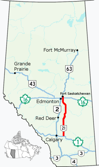
Alberta Provincial Highway No. 21, commonly referred to as Highway 21, is a north–south highway in Alberta, Canada that parallels Highway 2 between Calgary and Edmonton. It is approximately 328 kilometres (204 mi) in length. It begins at the Trans-Canada Highway (Highway 1) east of Strathmore, and ends at Fort Saskatchewan where it is succeeded by Highway 15. The northernmost 25 kilometres (16 mi) of the highway are twinned. Highway 21 runs roughly parallel to the main north–south CN rail line between Calgary and Edmonton between Three Hills and Looma.

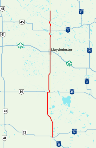
Alberta Provincial Highway No. 14, commonly referred to as Highway 14, is an east-west highway in central Alberta, Canada. It stretches from Edmonton through Wainwright to the Alberta–Saskatchewan border, running parallel to the more northern Highway 16. Highway 14 is about 257 kilometres (160 mi) long.
Alberta Provincial Highway No. 13, commonly referred to as Highway 13, is an east–west highway through central Alberta. It runs from Alder Flats, 7 km (4 mi) west of Highway 22, to the Alberta-Saskatchewan border, where it becomes Saskatchewan Highway 14. Highway 13 is about 366 kilometres (227 mi) long. East of the City of Wetaskiwin, it generally parallels a Canadian Pacific Kansas City rail line.

Alberta Provincial Highway No. 9, commonly referred to as Highway 9, is a highway in south-central Alberta, Canada, which together with Saskatchewan Highway 7 connects Calgary to Saskatoon, Saskatchewan via Drumheller. It is designated as a core route of the National Highway System, forming a portion of an interprovincial corridor. Highway 9 spans approximately 324 km (201 mi) from the Trans-Canada Highway east of Calgary to Alberta's border with Saskatchewan.
Highway 17 is a highway in Canada that straddles and criss-crosses the Alberta–Saskatchewan provincial border. The portion from the provincial border at Dillberry Lake Provincial Park to the provincial border 800 metres (2,600 ft) north of the North Saskatchewan River is designated as Alberta Provincial Highway No. 17 by Alberta Transportation, commonly referred to as Highway 17.

Alberta Provincial Highway No. 11A is the designation of two routes that connect to Highway 11 in Alberta, Canada. The Rocky Mountain House section is referred to as 11A:02 by Alberta Transportation, while 11A:06 runs from Sylvan Lake to Red Deer.

Alberta Provincial Highway No. 28, commonly referred to as Highway 28, is a highway in north-central Alberta, Canada that connects Edmonton to Cold Lake. It begins at Yellowhead Trail (Highway 16) in Edmonton as 97 Street NW, running through the city's north suburbs before entering Sturgeon County and passing CFB Edmonton. After merging with Highway 28A near Gibbons it winds through agricultural lands of north-central Alberta, roughly paralleling the North Saskatchewan River until Smoky Lake before continuing east through St. Paul County to Bonnyville. It turns northeast to CFB Cold Lake, before ending at Lakeshore Drive in the city of Cold Lake shortly thereafter.
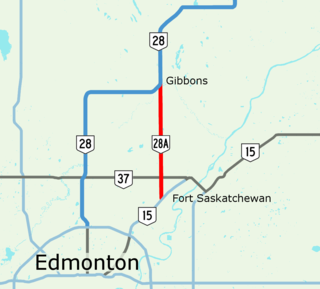
Alberta Provincial Highway No. 28A, commonly referred to as Highway 28A, is an 18-kilometre (11 mi) highway in Alberta, Canada that connects Highway 15 in northeast Edmonton to Highway 28 near Gibbons. It is numbered 17 Street NE within Edmonton and forms an alternate route to Highway 28 into the city from the north. As the southernmost component of the Edmonton–Fort McMurray corridor, the highway is designated as a core route of Canada's National Highway System for its entire length.
Alberta Provincial Highway No. 33, commonly referred to as Highway 33 and officially named Grizzly Trail, is a north–south highway in west–central Alberta, Canada.
Alberta Provincial Highway No. 37 is a highway in the province of Alberta, Canada. It runs in an east–west direction just north of St. Albert and Edmonton, from west of Onoway to west of Fort Saskatchewan.
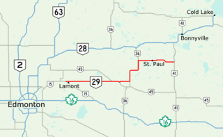
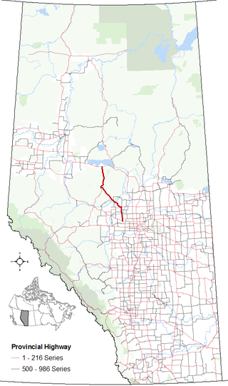
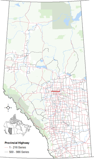
Alberta Provincial Highway No. 29, commonly referred to as Highway 29, is a 153-kilometre (95 mi) highway in east–central Alberta, Canada that connects Highway 15 near Lamont to Highway 41 north of Elk Point. It runs mostly west to east across aspen parkland through Hairy Hill, turning north through Duvernay, Brosseau, Foisy, St. Brides, and east to St. Paul before ending at Highway 41 approximately 9 km (5.6 mi) north of Elk Point, concurrent with Highways 36 and 45 for lengthy sections.
Highway 55 is a paved, undivided provincial highway in the Canadian province of Saskatchewan. It runs from the Alberta border west of Pierceland to Highway 9 near Mountain Cabin. Highway 55 is about 652 kilometres (405 mi) long and forms part of the interprovincial Northern Woods and Water Route.

Highway 47 is a highway in the Canadian province of Saskatchewan. It runs from North Dakota Highway 40 at the Canada–United States border until Highway 49 near Preeceville. Highway 47 is about 358 km (222 mi) long. Highway 47 is unpaved for 64 km (40 mi), from the Moose Mountain Creek crossing until the intersection with Highway 1.
Fort Road and Manning Drive is a major arterial road in Edmonton, Alberta, Canada. It is a major route in connecting Edmonton and Fort Saskatchewan formed on the west side of the Canadian National Railway line that itself formerly connected the two cities. Fort Road formerly connected Edmonton and Fort Saskatchewan in its entirety and was part of Alberta Highway 15; however the section north of 137 Avenue was bypassed and named Manning Drive. Fort Road gets its name for its connection to Fort Saskatchewan, while Manning Drive is after Ernest Manning, the premier of Alberta from 1943 to 1968.
Alberta Provincial Highway No. 16X, commonly referred to as Highway 16X, is the designation of one former and three proposed routes off Highway 16 in Alberta, Canada. The former section was a 36 km (22 mi) east–west provincial highway in Edmonton Capital Region, that existed for approximately 20 years between the 1970s and 1997 and is now part of Highway 16. Right of way is set aside around Hinton, Edson, and Lloydminster that is presently designated as Highway 16X.
Calgary Trail and Gateway Boulevard are a pair of major arterial roadways in Edmonton, Alberta. Gateway Boulevard carries northbound traffic while Calgary Trail carries southbound traffic. From south of 31 Avenue, they form a two-way freeway separated by a median; for this portion, the roadway maintains the separate names for northbound and southbound traffic. Near 31 Avenue, Calgary Trail and Gateway Boulevard separate and become parallel one-way arterial roadways to Saskatchewan Drive, at the edge of the North Saskatchewan River valley. Designated as part of Highway 2 south of Whitemud Drive, it is Edmonton's main southern entrance and is both a major commuter route, connecting to the Edmonton International Airport and Leduc, as well as a regional connection to Red Deer and Calgary.