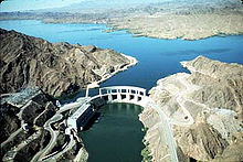
Hoover Dam is a concrete arch-gravity dam in the Black Canyon of the Colorado River, on the border between the U.S. states of Nevada and Arizona. Constructed between 1931 and 1936, during the Great Depression, it was dedicated on September 30, 1935, by President Franklin D. Roosevelt. Its construction was the result of a massive effort involving thousands of workers, and cost over 100 lives. In bills passed by Congress during its construction, it was referred to as the Hoover Dam, after President Herbert Hoover, but was named the Boulder Dam by the Roosevelt administration. In 1947, the name Hoover Dam was restored by Congress.

The Colorado River is one of the principal rivers in the Southwestern United States and in northern Mexico. The 1,450-mile-long (2,330 km) river, the 5th longest in the United States, drains an expansive, arid watershed that encompasses parts of seven U.S. states and two Mexican states. The name Colorado derives from the Spanish language for "colored reddish" due to its heavy silt load. Starting in the central Rocky Mountains of Colorado, it flows generally southwest across the Colorado Plateau and through the Grand Canyon before reaching Lake Mead on the Arizona–Nevada border, where it turns south toward the international border. After entering Mexico, the Colorado approaches the mostly dry Colorado River Delta at the tip of the Gulf of California between Baja California and Sonora.

The Mojave River is an intermittent river in the eastern San Bernardino Mountains and the Mojave Desert in San Bernardino County, California, United States. Most of its flow is underground, while its surface channels remain dry most of the time, except for the headwaters and several bedrock gorges in the lower reaches.

The Los Angeles Aqueduct system, comprising the Los Angeles Aqueduct and the Second Los Angeles Aqueduct, is a water conveyance system, built and operated by the Los Angeles Department of Water and Power. The Owens Valley aqueduct was designed and built by the city's water department, at the time named The Bureau of Los Angeles Aqueduct, under the supervision of the department's Chief Engineer William Mulholland. The system delivers water from the Owens River in the eastern Sierra Nevada mountains to Los Angeles.

The Colorado River Aqueduct, or CRA, is a 242 mi (389 km) water conveyance in Southern California in the United States, operated by the Metropolitan Water District of Southern California (MWD). The aqueduct impounds water from the Colorado River at Lake Havasu on the California-Arizona border, west across the Mojave and Colorado deserts to the east side of the Santa Ana Mountains. It is one of the primary sources of drinking water for Southern California.

Lake Havasu is a large reservoir formed by Parker Dam on the Colorado River, on the border between San Bernardino County, California and Mohave County, Arizona. Lake Havasu City sits on the Arizonan side of the lake with its Californian counterpart of Havasu Lake directly across the lake. The reservoir has an available capacity of 619,400 acre-feet (0.7640 km3). The concrete arch dam was built by the United States Bureau of Reclamation between 1934 and 1938. The lake's primary purpose is to store water for pumping into two aqueducts. Prior to the dam construction, the area was home to the Mojave people. The lake was named after the Mojave word for blue. In the early 19th century, it was frequented by beaver trappers. Spaniards also began to mine the areas along the river.
Path 46, also called West of Colorado River, Arizona-California West-of-the-River Path (WOR), is a set of fourteen high voltage alternating-current transmission lines that are located in southeast California and Nevada up to the Colorado River.

The Lower Colorado River Valley (LCRV) is the river region of the lower Colorado River of the southwestern United States in North America that rises in the Rocky Mountains and has its outlet at the Colorado River Delta in the northern Gulf of California in northwestern Mexico, between the states of Baja California and Sonora. This north–south stretch of the Colorado River forms the border between the U.S. states of California/Arizona and Nevada/Arizona, and between the Mexican states of Baja California/Sonora.

The Imperial Reservoir is an artificial lake formed by the construction of the Imperial Diversion Dam across the Colorado River in the Lower Colorado River Valley of Imperial County, California, and Yuma County, Arizona. Partially included in the Imperial National Wildlife Refuge, the reservoir is 16 miles (26 km) northeast of Yuma, Arizona.

The Sacramento Wash is a major drainage of northwest Arizona in Mohave County. The wash is east of the Black Canyon of the Colorado and drains into the south-flowing Colorado River 45 mi south of Lake Mohave, and 90 mi south of Hoover Dam at Lake Mead. The wash outfall is in the center-south of the Havasu-Mohave Lakes Watershed. An equivalent wash drains to the west of the Colorado River and the Black Canyon, draining southeast Nevada and a small part of California, the Piute Wash of the Piute Valley. The Piute Wash outfall is upstream of the Sacramento's outfall by about 15 miles.

The Alamo Canal was a 14 mi (23 km) long waterway that connected the Colorado River to the head of the Alamo River. The canal was constructed to provide irrigation to the Imperial Valley. A small portion of the canal was located in the United States but the majority of the canal was located in Mexico. The Alamo Canal is also known as the Imperial Canal.
The Aubrey Peak Wilderness is a 15,400-acre (6,230 ha) wilderness administered by the Bureau of Land Management (BLM). The wilderness is located in northwest Arizona in the southwest of Mohave County, a region of the southeastern Mojave Desert's extension into northwest Arizona.
The Yuma Project is a U.S. Bureau of Reclamation project built to irrigate over 68,000 acres (280 km2) of land in Yuma County, Arizona and parts of Imperial County, California. The project is designed to exploit year-round farming conditions and water from the Colorado River. It consists of the Laguna Diversion Dam, pumping plants, a power plant, a 53-mile (85 km) system of canals, 218 miles (351 km) of lateral canals, levees and drains. The project began in 1903 and the majority of the work was completed by 1915. It was the first dam and reclamation project on the Colorado River and workers had to overcome many natural and logistical obstacles to build and maintain it. The Laguna Diversion Dam was replaced by the Imperial Dam as the Project's water source between 1941 and 1948. Today, it serves 275 farms and over 94,000 people.

Vidal Valley is a 20-mile (32 km) long valley in the far eastern Colorado Desert bordering the Colorado River. Most of the valley is in eastern San Bernardino County, California, but the outfall on the Colorado River is in northeast Riverside County. Vidal Valley forms the large border of the south side of the east-west block of the Whipple Mountains massif, the landform that forces the Colorado to flow southeast, then back southwest. The southeast exit of the valley into Parker Valley on the Colorado River skirts the north end of the Riverside Mountains. The Colorado River Aqueduct crosses the midpoint of the valley at Vidal Junction, California. The Vidal Valley also lies due east of the Danby Dry Lake landform.

The Palo Verde Valley is located in the Lower Colorado River Valley, next to the eastern border of Southern California with Arizona, United States. It is located on the Colorado Desert within the Sonoran Desert south of the Parker Valley. Most of the valley is in Riverside County, with the southern remainder in Imperial County. La Paz County borders to the east on the Colorado River.

The Colorado River is a major river of the western United States and northwest Mexico in North America. Its headwaters are in the Rocky Mountains where La Poudre Pass Lake is its source. Located in north central Colorado it flows southwest through the Colorado Plateau country of western Colorado, southeastern Utah and northwestern Arizona where it flows through the Grand Canyon. It turns south near Las Vegas, Nevada, forming the Arizona–Nevada border in Lake Mead and the Arizona–California border a few miles below Davis Dam between Laughlin, Nevada and Needles, California before entering Mexico in the Colorado Desert. Most of its waters are diverted into the Imperial Valley of Southern California. In Mexico its course forms the boundary between Sonora and Baja California before entering the Gulf of California. This article describes most of the major features along the river.