
The Colorado River is one of the principal rivers in the Southwestern United States and northern Mexico. The 1,450-mile-long (2,330 km) river drains an expansive, arid watershed that encompasses parts of seven U.S. states and two Mexican states. The name Colorado derives from the Spanish language for "colored reddish" due to its heavy silt load. Starting in the central Rocky Mountains of Colorado, it flows generally southwest across the Colorado Plateau and through the Grand Canyon before reaching Lake Mead on the Arizona–Nevada border, where it turns south toward the international border. After entering Mexico, the Colorado approaches the mostly dry Colorado River Delta at the tip of the Gulf of California between Baja California and Sonora.

Glen Canyon Dam is a concrete arch-gravity dam on the Colorado River in northern Arizona, United States, near the town of Page. The 710-foot (220 m) high dam was built by the U.S. Bureau of Reclamation (USBR) from 1956 to 1966 and forms Lake Powell, one of the largest man-made reservoirs in the U.S. with a capacity of more than 25 million acre-feet (31 km3). The dam is named for Glen Canyon, a series of deep sandstone gorges now flooded by the reservoir; Lake Powell is named for John Wesley Powell, who in 1869 led the first expedition to traverse the Colorado River's Grand Canyon by boat.

The Gila River is a 649-mile (1,044 km)-long tributary of the Colorado River flowing through New Mexico and Arizona in the United States. The river drains an arid watershed of nearly 60,000 square miles (160,000 km2) that lies mainly within the U.S., but also extends into northern Sonora, Mexico.

The Salt River is a river in Gila and Maricopa counties in Arizona, United States, that is the largest tributary of the Gila River. The river is about 200 miles (320 km) long. Its drainage basin is about 13,700 square miles (35,000 km2) large. The longest of the Salt River's many tributaries is the 195-mile (314 km) Verde River. The Salt's headwaters tributaries, the Black River and East Fork, increase the river's total length to about 300 miles (480 km). The name Salt River comes from the fact that the river flows over large salt deposits shortly after the merging of the White and Black Rivers.

The Boise River is a 102-mile-long (164 km) tributary of the Snake River in the Northwestern United States. It drains a rugged portion of the Sawtooth Range in southwestern Idaho northeast of Boise, as well as part of the western Snake River Plain. The watershed encompasses approximately 4,100 square miles (11,000 km2) of highly diverse habitats, including alpine canyons, forest, rangeland, agricultural lands, and urban areas.
The Salt River Project (SRP) is the umbrella name for two separate entities: the Salt River Project Agricultural Improvement and Power District, an agency of the state of Arizona that serves as an electrical utility for the Phoenix metropolitan area, and the Salt River Valley Water Users' Association, a utility cooperative that serves as the primary water provider for much of central Arizona. It is one of the primary public utility companies in Arizona.

Pine Flat Dam is a concrete gravity dam on the Kings River in the Central Valley of Fresno County, California United States. Situated about 28 miles (45 km) east of Fresno, the dam is 440 feet (130 m) high and impounds Pine Flat Lake, one of the largest reservoirs in California, in the foothills of the Sierra Nevada just outside the boundary of Kings Canyon National Park. The dam's primary purpose is flood control, with irrigation, hydroelectric power generation and recreation secondary in importance.

The Colorado–Big Thompson Project is a federal water diversion project in Colorado designed to collect West Slope mountain water from the headwaters of the Colorado River and divert it to Colorado's Front Range and plains. In Colorado, approximately 80% of the state's precipitation falls on the West Slope, in the Rocky Mountains, while around 80% of the state's growing population lives along the eastern slope, between the cities of Fort Collins and Pueblo.
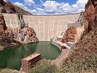
Theodore Roosevelt Dam is a dam on the Salt River located northeast of Phoenix, Arizona. The dam is 357 feet (109 m) high and forms Theodore Roosevelt Lake as it impounds the Salt River. Originally built between 1905 and 1911, the dam was renovated and expanded in 1989–1996. The dam is named after President Theodore Roosevelt. Serving mainly for irrigation, water supply, and flood control, the dam also has a hydroelectric generating capacity of 36 megawatts.

Lake Tahoe Dam is a concrete gravity dam on the Truckee River, at the outlet of Lake Tahoe in Placer County, California.

Heron Dam is a storage dam Rio Arriba County, in northern New Mexico in the southwestern United States, just north of the El Vado Dam. It is owned and operated by the United States Bureau of Reclamation. The dam is about 9 miles west of the town of Tierra Amarilla.


