This is a list of the extreme points of Singapore, the points that are farther north, south, east, or west than any other location in the country. Also included are extreme points in elevation. Both the extreme points for the main island (Pulau Ujong) and the outlying islands of Singapore are indicated.

Changi is a planning area located in the geographical region of Tanah Merah in the East Region of Singapore. Sharing borders with Pasir Ris and Tampines to the west, Changi Bay to the southeast, the South China Sea to the east and the Serangoon Harbour to the north. Changi, excluding the two water catchments and islands of Singapore, is the largest planning area by land size.

The East–West Line (EWL) is a high-capacity Mass Rapid Transit (MRT) line operated by SMRT in Singapore, running from Pasir Ris station in the east to Tuas Link station in the west, with an additional branch between Changi Airport and Tanah Merah stations. It is the second Mass Rapid Transit line to be built in Singapore. The 57.2 kilometres (35.5 mi) line is the longest on the MRT network, with 35 stations, 8 of which are underground. The line is coloured green on the rail map.

This is a list of the extreme points of Ireland – the points that are farthest north, south, east or west in Ireland. It includes the Republic of Ireland and Northern Ireland.
This is a list of the extreme points of Europe: the geographical points that are higher or farther north, south, east or west than any other location in Europe. Some of these positions are open to debate, as the definition of Europe is diverse.
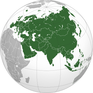
This is a list of the extreme points of Asia, the points that are farther north, south, east or west than any other location on the continent.
This is a list of the extreme points of Eurasia, the points that are farther north, south, east or west than any other location on the continent. Some of these locations are open to debate, owing to the diverse definitions of Europe and Asia.
The extreme points of Norway include the coordinates that are farther north, south, east or west than any other location in Norway; and the highest and the lowest altitudes in the country. The northernmost point is Rossøya on Svalbard, the southernmost is Pysen in Mandal, the easternmost is Kræmerpynten on Svalbard, and the westernmost is Hoybergodden on Jan Mayen. The highest peak is Galdhøpiggen, standing at 2,469 m (8,100 ft) above mean sea level, while the lowest elevation is sea level at the coast.

Bedok is a planning area and matured residential town located in the geographical region of Tanah Merah along the south-eastern coast of the East Region of Singapore. Bedok is bounded by five other planning areas: Paya Lebar to the north, Hougang to the northwest, Tampines to the northeast and east, Geylang to the west and Marine Parade to the southwest. It also shares a maritime boundary with the Singapore Strait to the south and southeast.
Changi Village is a modern village situated at the northern tip of Changi which is at the eastern end of Singapore. It is the usual connecting point for travellers heading to Pulau Ubin or Malaysia by ferry. Fishermen in the kelongs located in the Serangoon Harbour offshore also use this jetty as a drop off point to come onto mainland. Changi Village also has many resorts and leisure facilities to cater for a weekend getaway for many Singaporeans. The area is classified by Urban Redevelopment Authorities as under the planning area of Changi and in the subzone of Changi Point. It is also classified under District 17 for property indexing.

Sembawang Bus Interchange is a bus interchange located in Sembawang, Singapore. Opened on 20 November 2005, it provides hassle-free transfer to the nearby Sembawang MRT station.

Sengkang Bus Interchange is a bus interchange located on the ground level of Compass Heights condominium in the town centre of Sengkang New Town, Singapore. Located next to Sengkang MRT/LRT station, it is the second bus interchange in Singapore to be air conditioned. It was opened on 18 January 2003.
Bukit Merah Bus Interchange is a bus interchange located in the Bukit Merah Town Centre, along Bukit Merah Central in Bukit Merah, Singapore. The interchange serves the nearby residential estates of Telok Blangah and Bukit Purmei and also the commercial buildings in Bukit Merah Central. It is the only bus interchange in Singapore that does not have a direct link to an MRT station. However, several services link commuters to nearby MRT stations from the interchange. Services 5, 16 and 851 link the interchange to Tiong Bahru, Service 132 links to Redhill, while Service 176 links to Telok Blangah.
Sembawang Park is a 15-hectare park situated in Sembawang, in the north of Singapore facing the Straits of Johor overlooking Malaysia. It is located at the end of Sembawang Road, where the former Sembawang Road End Bus Terminal was.

Singapore Island or Pulau Ujong, is the main constituent island of the sovereign island country and city-state of the Republic of Singapore. It is located at the southern tip of Malay Peninsula, in-between the Straits of Malacca and the South China Sea. The Singapore Strait lies to the south, while the Johor Strait lies to the north.

Serangoon Harbour is a harbour in Singapore located between the mainland island of Singapore and Pulau Ubin.