This article needs additional citations for verification .(April 2022) |
This is an incomplete list of ghost towns in Delaware .
Contents

This article needs additional citations for verification .(April 2022) |
This is an incomplete list of ghost towns in Delaware .

| Town name | Other name(s) | County | Established | Disestablished | Remarks |
|---|---|---|---|---|---|
| Banning | Sussex | ||||
| Glenville | New Castle | Never recovered from the damage caused by Tropical Storm Henri in 2003 and was abandoned by 2004. [1] | |||
| New Market | Sussex | ||||
| Owens Station | Sussex | ||||
| Saint Johnstown | Sussex | ||||
| Woodland | Sussex | ||||
| Woodland Beach | Kent | ||||
| Zwaanendael | Swaanendael, Zwaanendael Colony, Swaanendael Colony | New Castle | First settlement in the state [2] |

Delaware is a state in the Mid-Atlantic region of the United States. It borders Maryland to its south and west, Pennsylvania to its north, New Jersey to its northeast, and the Atlantic Ocean to its east. The state's name derives from the adjacent Delaware Bay, which in turn was named after Thomas West, 3rd Baron De La Warr, an English nobleman and the Colony of Virginia's first colonial-era governor.
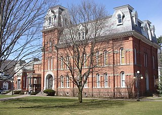
Delaware County is a county located in the US state of New York. As of the 2020 United States census, the population was 44,308. The county seat is Delhi. The county is named after the Delaware River, which was named in honor of Thomas West, 3rd Baron De La Warr, appointed governor of Virginia in 1609. The county is part of the Southern Tier region of the state.

Dover is the capital and second-most populous city of the U.S. state of Delaware. It is also the county seat of Kent County and the principal city of the Dover metropolitan statistical area, which encompasses all of Kent County and is part of the Philadelphia–Wilmington–Camden, PA–NJ–DE–MD, combined statistical area. It is located on the St. Jones River in the Delaware River coastal plain. It was named by William Penn for Dover in Kent, England. As of 2020, its population was 39,403.
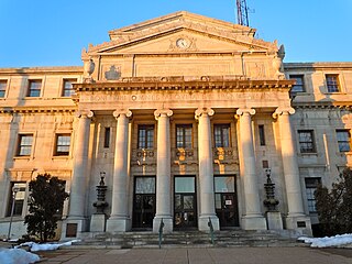
Delaware County, colloquially referred to as Delco, is a county in the Commonwealth of Pennsylvania. With a population of 576,830 as of the 2020 census, it is the fifth-most populous county in Pennsylvania and the third-smallest in area. The county was created on September 26, 1789, from part of Chester County and named for the Delaware River. The county is part of the Southeast Pennsylvania region of the state.
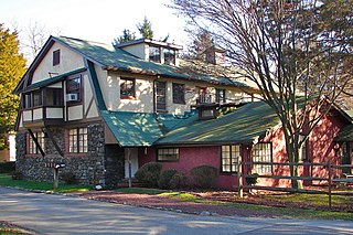
Arden is a village in New Castle County, Delaware, United States, founded in 1900 as a radical Georgist single-tax community by sculptor Frank Stephens and architect William Lightfoot Price. The village occupies approximately 160 acres, with half kept as open land. According to the 2010 census, the population of the village is 439. In 1973, the entire village was listed on the National Register of Historic Places.
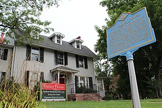
Claymont is a census-designated place (CDP) in New Castle County, Delaware, United States. As of the 2020 U.S. census, the population of Claymont was 9,895.

Hockessin is a census-designated place (CDP) in New Castle County, Delaware, United States. The population was 13,478 at the 2020 Census.

Wilmington is the largest city in the U.S. state of Delaware. The city was built on the site of Fort Christina, the first Swedish settlement in North America. It lies at the confluence of the Christina River and Brandywine Creek, near where the Christina flows into the Delaware River. It is the county seat of New Castle County and one of the major cities in the Delaware Valley metropolitan area. Wilmington was named by Proprietor Thomas Penn after his friend Spencer Compton, Earl of Wilmington, who was prime minister during the reign of George II of Great Britain.

South Bethany is an incorporated town in Sussex County, Delaware, United States. According to the 2010 census, the population of the town is 449, a decrease of 8.7% over the previous decade. It is part of the Salisbury, Maryland-Delaware Metropolitan Statistical Area.
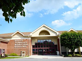
Ridley Township is a township in Delaware County, Pennsylvania, United States. The population was 30,768 at the 2010 census. Ridley Township contains the (CDPs) of Folsom and Woodlyn, along with the unincorporated communities of Crum Lynne and Holmes and a portion of Secane.

U.S. Route 113 (US 113) is a U.S. Highway that is a spur of US 13 in the U.S. states of Maryland and Delaware. The route runs 74.75 miles (120.30 km) from US 13 in Pocomoke City, Maryland, north to Delaware Route 1 (DE 1) in Milford, Delaware. In conjunction with DE 1, US 113 is one of two major north–south highways on the Delmarva Peninsula that connect Dover with Pocomoke City and the Eastern Shore of Virginia. The U.S. Highway is the primary north–south highway in Worcester County, Maryland, where it connects Pocomoke City with Snow Hill and Berlin. US 113 is one of three major north–south highways in Sussex County, Delaware, where it connects Selbyville, Millsboro, and Georgetown with Milford. While US 113 does not pass through Ocean City or the Delaware Beaches, the U.S. Highway intersects several highways that serve the Atlantic seaboard resorts, including US 50, Maryland Route 90 (MD 90), US 9, DE 404, DE 16, and DE 1. US 113 is a four-lane divided highway for its whole length.

Delaware Route 1 (DE 1) is the longest numbered state highway in the U.S. state of Delaware. The route runs 102.63 mi (165.17 km) from the Maryland state line in Fenwick Island, Sussex County, where the road continues south into that state as Maryland Route 528 (MD 528), north to an interchange with Interstate 95 (I-95) in Christiana, New Castle County, where the roadway continues north as part of DE 7. Between Fenwick Island and Dover Air Force Base in Dover, Kent County, DE 1 is a multilane divided highway with at-grade intersections and occasional interchanges. The route heads north through the Delaware Beaches resort area along the Atlantic Ocean before it runs northwest through rural areas, turning north at Milford to continue to Dover. Upon reaching Dover, DE 1 becomes the Korean War Veterans Memorial Highway, a freeway that is partially tolled. Between Dover and Tybouts Corner, DE 1 parallels U.S. Route 13 (US 13), crossing over and featuring interchanges with it multiple times. Past Tybouts Corner, the freeway heads north parallel to DE 7 to the northern terminus of DE 1 in Christiana. DE 1 serves as the main north-south state highway in Delaware, connecting the Delaware Beaches with the Dover and Wilmington areas.

Delaware Technical Community College is a public community college in the U.S. state of Delaware. Delaware Tech is an open admission institution accredited by the Middle States Commission on Higher Education.

Glenville is a ghost town in Delaware, United States, at 39°42′45″N75°38′24″W. The community consisted of a development on Bread and Cheese Island, on the east bank of the Red Clay Creek near its mouth, just south of Delaware Route 4 near Stanton. Located in the floodplain for Red Clay Creek, the subdivision has always been prone to flooding, such as flooding from Hurricane Floyd in 1999 and Tropical Storm Henri in 2003. After floods caused by Tropical Storm Henri on September 15, 2003, homeowners were bought out by the state and local government, and the community was abandoned in 2004. Demolition began in 2005. As of 2023, the remains of the town are fenced off to prevent trespassers.
Gwinhurst is an unincorporated community in New Castle County, Delaware, United States in the Philadelphia-Camden-Wilmington Metropolitan Statistical Area.
Talleyville is an unincorporated community in New Castle County, Delaware, United States. Talleyville is located at the intersection of U.S. Route 202, Mt. Lebanon Road, and Silverside Road to the north of Wilmington. Its ZIP code is 19803.
Zoar is an unincorporated community located in Sussex County, Delaware, United States.
Ward is an unincorporated community in Sussex County, Delaware, United States. in the Little Creek Hundred.
Delaire is a suburban community in New Castle County, Delaware, United States.
Pinetown is an unincorporated community in Sussex County, Delaware, United States. Pinetown is located on Sweet Briar Road near Red Mill Pond, southwest of Lewes.
{{cite book}}: CS1 maint: location missing publisher (link)