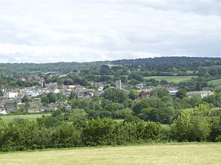
Axminster is a market town and civil parish on the eastern border of the county of Devon in England. It is 28 miles (45 km) from the county town of Exeter. The town is built on a hill overlooking the River Axe which heads towards the English Channel at Axmouth, and is in the East Devon local government district. At the 2001 census, it had a population of 5,626, increasing to 5,761 at the 2011 census. The town contains two electoral wards whose combined population is 7,110. The market is still held every Thursday.

Ellendale is a town in Sussex County, Delaware, United States. The population was 487 at the 2020 census, an increase of 27.8% since the 2010 census, and a 48.9% increase since the year 2000. It is part of the Salisbury, Maryland-Delaware Metropolitan Statistical Area. Ellendale is the "Gateway to Delaware's Resort Beaches" because it is the town located on U.S. Route 113, the resort area's westernmost border, and Delaware Route 16, the resort area's northernmost border with the eastern border being the Delaware Bay and Atlantic Ocean and the southern border being the state line with Maryland.
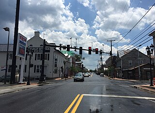
New Market is a town in Shenandoah County, Virginia, United States. Founded as a small crossroads trading town in the Shenandoah Valley, it has a population of 2,146 as of the most recent 2010 U.S. census. The north–south U.S. 11 and the east–west U.S. 211 pass near it and cross Massanutten Mountain at the town's titular gap.

Draperstown is a village in the Sperrin Mountains in County Londonderry, Northern Ireland. It is situated in the civil parish of Ballinascreen and is part of Mid-Ulster district. It is also part of the Church of Ireland parish of Ballynascreen and the Catholic parish of Ballinascreen, and within the former barony of Loughinsholin.
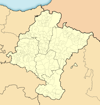
Urroz is a town and municipality located in the province and autonomous community of Navarre, northern Spain. The town has a small cemetery, and a "pelota" court, a church, and two or three small bars around a little plaza.
Owens is a small unincorporated crossroads community at the intersection of Dahlgren Road, Windsor Drive, and Owens Drive in King George County, Virginia, United States. State Routes 206 and 218 meet at this intersection, with 206 going east towards U.S. Route 301 and Dahlgren, 218 going south towards US 301 and Colonial Beach and 206 and 218 joined together going west towards Arnolds Corner and Fredericksburg. The eastern part of the community is within the Dahlgren census-designated place.

Delaware Route 16 (DE 16) is an east-west state highway in Delaware, mainly across northern Sussex County, with a small portion near the Maryland border in extreme southwestern Kent County. It runs from Maryland Route 16 (MD 16) at the Maryland border in Hickman east to the Delaware Bay at Broadkill Beach. The route passes through rural areas along with the towns of Greenwood, Ellendale, and Milton. DE 16 intersects DE 36 and U.S. Route 13 (US 13) in Greenwood, US 113 in Ellendale, DE 30 and DE 5 in the Milton area, and DE 1 between Milton and Broadkill Beach. West of DE 1, the route serves as part of a connection between the Baltimore–Washington Metropolitan Area and the Delaware Beaches. DE 16 was built as a state highway during the 1920s and 1930s. By 1936, the route was designated onto its current alignment.

Willowdale is an unincorporated community that is located in East Marlborough Township, in southern Chester County, Pennsylvania, United States.
Hamptonville is an unincorporated community located in southwestern Yadkin County, North Carolina, United States. Hamptonville is named for Henry Hampton (1750–1832), a colonel in the Revolutionary Army. Hampton set aside land for a town in 1806.
Cedar Creek is a collection of developments and residences mainly surrounding Swiggetts Pond and Cubbage Pond along the Cedar Creek in Sussex County, Delaware, United States. It is part of the Salisbury, Maryland-Delaware Metropolitan Statistical Area. The area generally referred to as Cedar Creek follows Fleatown Road from Clendaniel Pond Road to Delaware Route 1, then heads south to Slaughter Neck Road, following Slaughter Neck Road until it connects with Cubbage Pond Road, ending back at the intersection of Cubbage Pond Road and Fleatown Road. The developments include Cedar Creek Estates, Cedar Village, The Meadows on Cubbage Pond, South Shores, The Village at Anderson Crossroads, and Pine Haven Park. Cedar Creek Nature Preserve is also located here off Brick Granary Road where the Cedar Creek flows into Swiggetts Pond.
Saint Johnstown, Delaware, USA was a stop on the now defunct Queen Anne's Railroad line between Ellendale and Greenwood. After the railroad closed down and the tracks were removed, all property owned by the railroad was returned to its previous landowners and several small towns built around the stops disappeared.
Owens Station, Delaware was a community in Delaware, U.S.A.

Culmore, Virginia is a small commercial center in Fairfax County, Virginia, United States. It sits between Seven Corners and the Skyline area on State Route 7.

Creagerstown is an unincorporated community in Frederick County, Maryland, United States. It is playfully known by its residents as "4 miles from everywhere" because of its situation at 4 miles (6.4 km) from Thurmont, Woodsboro, Rocky Ridge, and Lewistown.
Crossroads Community Cathedral is a multi-cultural church located at the town line of East Hartford, Connecticut, and Manchester. A second campus opened in East Windsor in 2020. Pastor Sean Wiles serves as the senior pastor. Bishop Terry Wiles was the senior pastor of the church and has judicial oversight of churches in Central and South America. The church was originally called First Assembly of God.

Deadwood is an unincorporated community in Panola County, Texas, United States. The community is located at the intersection of Farm to Market Road 31 and Farm to Market Road 2517, about 10 miles (16 km) east of Carthage.
Federalsburg is an unincorporated community in Sussex County, Delaware, United States. Federalsburg was located at the intersection of Old State Road and Fleatown Road, north of Ellendale.

Heidlersburg is an unincorporated community and census-designated place in Tyrone Township, Adams County, Pennsylvania, United States. As of the 2020 census, the population was 509.

Larisons Corners, also spelled Larison's Corners, is an unincorporated community located along the border of East Amwell and Raritan townships in Hunterdon County, New Jersey, United States.
Steelville is an unincorporated community in Chester County, Pennsylvania, United States. According to the 2016 census, the town has not been included in past census counts because the town is so small. It lies next to the Octoraro Creek: the border line between Lancaster County and Chester County.


