Related Research Articles

Kent County is a county located in the central part of the U.S. state of Delaware. As of the 2010 census, the population was 162,310, making it the least populous county in Delaware. The county seat is Dover, the state capital of Delaware. It is named for Kent, an English county.

Little Creek is a town in Kent County, Delaware, United States. It is part of the Dover, Delaware Metropolitan Statistical Area. The population was 224 at the 2010 census.
Claymont is a census-designated place (CDP) in New Castle County, Delaware, United States. The estimated 2017 population of the 19703 ZIP code, which Claymont encompasses, was 15,292.

Red Clay Creek is a 12.7-mile-long (20.4 km) tributary of White Clay Creek, running through southeastern Pennsylvania and northern Delaware in the United States. As of 2000, portions of the creek are under wildlife habitat protection.

The Bohemia River is a 4.7-mile-long (7.6 km) tributary of the Elk River on the Delmarva Peninsula. It is located in Cecil County, Maryland, with its headwaters extending into New Castle County, Delaware.
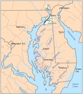
The Elk River is a tidal tributary of the Chesapeake Bay on the Eastern Shore of Maryland and on the northern edge of the Delmarva Peninsula. It is about 15 miles (24 km) long. As the most northeastern extension of the Chesapeake Bay estuary, it has served as one entrance to the Chesapeake & Delaware Canal since the 19th century. The canal and river now serve as one boundary of the Elk Neck Peninsula. The river flows through Cecil County, Maryland, with its watershed extending into New Castle County, Delaware and Chester County, Pennsylvania. Elkton, the county seat of Cecil County, is located at its head. Its total watershed area is 143 square miles (370 km2), with 21 square miles (54 km2) of open water, so its watershed is 15% open water. It is south and east of the North East River, and north of the Sassafras River.

Ridley Creek State Park is a 2,606-acre (1,055 ha) Pennsylvania state park in Edgmont, Middletown, and Upper Providence Townships, Delaware County, Pennsylvania in the United States. The park, about 5 miles (8 km) north of the county seat of Media, offers many recreational activities, such as hiking, biking, fishing, and picnicking. Ridley Creek passes through the park. Highlights include a 5-mile (8 km) paved multi-use trail, a formal garden designed by the Olmsted Brothers, and Colonial Pennsylvania Plantation, which recreates daily life on a pre-Revolutionary farm. The park is adjacent to the John J. Tyler Arboretum. Ridley Creek State Park is just over 16 miles (26 km) from downtown, Philadelphia between Pennsylvania Route 352 and Pennsylvania Route 252 on Gradyville Road.

Ridley Creek is a tributary of the Delaware River in Chester and Delaware counties, Pennsylvania in the United States.
Licking Creek is a 56.6-mile-long (91.1 km) tributary of the Potomac River in Pennsylvania and Maryland in the United States.

Marshallton is an unincorporated community in Mill Creek Hundred, New Castle County, Delaware, United States. The community was founded in 1836 and is named for John Marshall, mill owner.

The East Branch Brandywine Creek is a 27.4-mile-long (44.1 km) tributary of Brandywine Creek in Chester County, Pennsylvania in the United States.

Gwinhurst is an unincorporated community in New Castle County, Delaware, United States. Its altitude is 98 feet (30 m), and it is located at 39°47′30″N75°28′44″W.

Jefferson Township is one of thirteen townships in Putnam County, Indiana. As of the 2010 census, its population was 1,252 and it contained 525 housing units.

Dalton Township is one of fifteen townships in Wayne County, Indiana, United States. As of the 2010 census, its population was 566 and it contained 239 housing units.
Duck Creek Hundred is a hundred in Kent County, Delaware, United States. Duck Creek Hundred was formed in 1682 as one of the original Delaware Hundreds. Its primary community is Smyrna.
Kenton Hundred is a hundred in Kent County, Delaware, United States. Kenton Hundred was formed in 1869 from Duck Creek Hundred. Its primary community is Kenton.
North Murderkill Hundred is a hundred in Kent County, Delaware, United States. North Murderkill Hundred was formed in 1855 from Murderkill Hundred. Its primary community is Camden.
West Dover Hundred is a hundred in Kent County, Delaware, United States. West Dover Hundred was formed in 1859 from Dover Hundred. Its primary community is Hartly.

Nesquehoning Mountain or Nesquehoning Ridge is a 15–17-mile-long (24–27 km) coal bearing ridge dividing the waters of Lehigh Valley to the north from the Schuylkill River valley and the several near parallel ridgelines of the Ridge-and-valley Appalachians barrier range all local members of which run generally WSW-ENE in the greater overall area.
Steelville is an unincorporated community in Chester County, Pennsylvania, United States. According to the 2016 census, the town has not been included in past census counts because the town is so small. It lies next to the Octoraro Creek: the border line between Lancaster County and Chester County.
References
- ↑ "US Board on Geographic Names". United States Geological Survey. 2007-10-25. Retrieved 2008-01-31.

Coordinates: 39°39′46″N75°33′40″W / 39.66269722°N 75.56103333°W
| | This Delaware state location article is a stub. You can help Wikipedia by expanding it. |