
Delaware is a state in the Mid-Atlantic region of the United States, bordering Maryland to its south and west; Pennsylvania to its north; and New Jersey and the Atlantic Ocean to its east. The state takes its name from the nearby Delaware River, in turn named after Thomas West, 3rd Baron De La Warr, an English nobleman and Virginia's first colonial governor.

Lewes is an incorporated city on the Delaware Bay in eastern Sussex County, Delaware, United States. According to the 2010 census, the population is 2,747. Along with neighboring Rehoboth Beach, Lewes is one of the principal cities of Delaware's rapidly growing Cape Region. The city lies within the Salisbury, Maryland–Delaware Metropolitan Statistical Area. Lewes proudly claims to be "The First Town in The First State."
Frederica is a town in Kent County, Delaware, United States. It is part of the Dover, Delaware Metropolitan Statistical Area. The population was 774 at the 2010 census. ILC Dover, the company which manufactured the spacesuits for the Apollo and Skylab astronauts of the 1960s and 1970s, along with fabricating the suit component of the Space Shuttle's Extravehicular Mobility Unit (EMU), is located nearby.
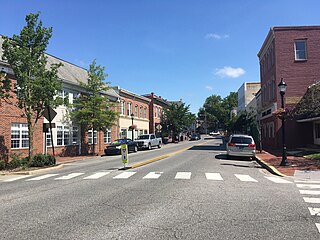
Milford is a city in Kent and Sussex counties in the U.S. state of Delaware. According to the 2020 census, the population of the city is 11,190 people and 4,356 households in the city.

Dewey Beach is an incorporated coastal town in eastern Sussex County, Delaware, United States. According to the 2010 census, the population of the town is 341, an increase of 13.3% over the previous decade. It is part of the rapidly growing Cape Region and lies within the Salisbury, Maryland-Delaware Metropolitan Statistical Area. In 2011, the NRDC awarded Dewey Beach with a 5-Star rating in water quality. This award was given only to 12 other locations, one being neighboring Rehoboth Beach. Out of the 30 states with coastline, the Delaware Beaches ranked number 1 in water quality in 2011.

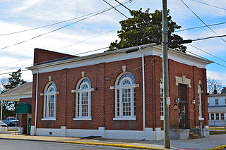
Georgetown is a town in and the county seat of Sussex County, Delaware, United States. According to the 2010 census, the population of the town is 6,422, an increase of 38.3% over the previous decade.
Delaware Route 1 (DE 1) is a 102.63-mile-long (165.17 km) state highway in the U.S. state of Delaware. The route runs from the Maryland state line in Fenwick Island, Sussex County, where the road continues south into that state as Maryland Route 528 (MD 528), north to an interchange with Interstate 95 (I-95) in Christiana, New Castle County, where the road continues north as part of DE 7. Between Fenwick Island and Dover Air Force Base in Dover, Kent County, DE 1 is a four- to six-lane divided highway with at-grade intersections and occasional interchanges. The route heads north through the Delaware Beaches resort area along the Atlantic Ocean before it runs northwest through rural areas, turning north at Milford to continue to Dover. Upon reaching Dover, DE 1 becomes the Korean War Veterans Memorial Highway, a four- to six-lane freeway that is partially tolled. Between Dover and Tybouts Corner, DE 1 parallels U.S. Route 13 (US 13), crossing over and featuring interchanges with it multiple times. Past Tybouts Corner, the freeway heads north parallel to DE 7 to its terminus in Christiana. DE 1 serves as the main north-south state route in Delaware, connecting the Delaware Beaches with the Dover and Wilmington areas.

Delaware Route 404 (DE 404) is a major state highway in Sussex County, Delaware that spans the east-west width of the state. DE 404's western terminus is at the Maryland border northwest of Bridgeville, where the road continues into that state as Maryland Route 404 (MD 404), and its eastern terminus is at the Five Points intersection with U.S. Route 9 (US 9), DE 1, and US 9 Business in Nassau. The route passes through rural areas as well as the towns of Bridgeville and Georgetown. DE 404 runs concurrent with DE 18 from east of Bridgeville to Georgetown and with US 9 from Georgetown to Five Points. DE 404 has a business route, DE 404 Bus., that passes through Bridgeville and a truck route, DE 404 Truck, that bypasses Georgetown. DE 404, along with MD 404, serves as a major route connecting the Chesapeake Bay Bridge and the Baltimore–Washington Metropolitan Area with the Delaware Beaches.

The Delaware Transit Corporation, operating as DART First State, is the only public transportation system that operates throughout the U.S. state of Delaware. DART First State provides local and inter-county bus service throughout the state and also subsidizes commuter rail service along SEPTA Regional Rail's Wilmington/Newark Line serving the northern part of the state. The agency also operates statewide paratransit service for people with disabilities. DART First State is a subsidiary of the Delaware Department of Transportation (DelDOT).
Gwinhurst is an unincorporated community in New Castle County, Delaware, United States in the Philadelphia-Camden-Wilmington Metropolitan Statistical Area.
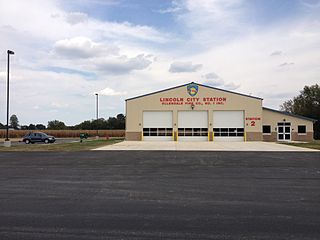
Lincoln is an
unincorporated community in northern Sussex County, Delaware, United States. It is part of the Salisbury, Maryland-Delaware Metropolitan Statistical Area. The planner who originally laid out the town planned for it to become the county seat. Lincoln lies on U.S. Route 113 between Ellendale and Milford. The town was never incorporated, but streets were laid out and several businesses and residences came, surrounding the current Delmarva Central Railroad line. Lincoln was formerly the headquarters of the Delaware Coast Line Railroad.
Lynnfield is a suburban community in New Castle County, Delaware, United States. Lynnfield is located northwest of the intersection of Delaware Route 3 and Baynard Boulevard, northeast of Wilmington.
Edenridge is an unincorporated community in New Castle County, Delaware, United States in the Brandywine Hundred, north of Wilmington.
Jimtown is an unincorporated community in Sussex County, Delaware, United States.
Redden is an unincorporated community in Sussex County, Delaware, United States. The community became an important railroad center on the Junction and Breakwater Railroad in the 1800s. The site of a historic 19th-century church and a World War II mess hall, Redden lost its post office and school in the 1930s.
Cleland Heights is an unincorporated community in New Castle County, Delaware, United States. It was established in 1952 and consists of about 450 houses.
A total of at least three special routes of U.S. Route 9 exist and at least three have been deleted.

The Delaware State Route System consists of roads in the U.S. state of Delaware that are maintained by the Delaware Department of Transportation (DelDOT). The system includes the portions of the Interstate Highway System and United States Numbered Highways system located in the state along with state routes and other roads maintained by DelDOT. All roads maintained by the state are assigned a maintenance road number that is only marked on little white markers at intersections and on auxiliary plates below warning signs approaching intersections. These numbers are only unique in a specific county; some roads can be designated with multiple road numbers, and numbers do not necessarily correspond to the signed Interstate, U.S., or state route numbers. DelDOT maintains a total of 5,386.14 miles (8,668.15 km) of roads, comprising 89 percent of the roads within the state. Some large bridges in the state are maintained by other agencies including the U.S. Army Corps of Engineers and the Delaware River and Bay Authority. Roads in the system include multilane freeways, multilane surface divided highways, and two-lane undivided roads serving urban, suburban, and rural areas. Some of the roads maintained by DelDOT are toll roads, in which motorists must pay to use.
Overbrook is an unincorporated community and former village in Sussex County, Delaware, United States.


