Tierra del Fuego is an archipelago off the southernmost tip of the South American mainland, across the Strait of Magellan.

Tierra del Fuego, officially the Province of Tierra del Fuego, Antarctica and South Atlantic Islands, is the southernmost, smallest, and least populous Argentine province. The provincial capital city is Ushuaia, from a native word meaning "bay towards the end".

Antártica Chilena Province is the southernmost of the four provinces in Chile's southernmost region, Magallanes and Antártica Chilena Region (XII). The capital is Puerto Williams. The province comprises the extreme southern part of Isla Grande de Tierra del Fuego, the islands south and west of Isla Grande, and Chile's claims in Antarctica. The province is administratively divided into two communes (comunas): Cabo de Hornos, located at the southern tip of South America, and Antártica, a wedge-shaped claim of Antarctica, which is not internationally recognized. Its total area of 1,265,853.7 km2 (488,749 sq mi) makes it almost twice as large as all other provinces of Chile combined.

Hoste Island is one of the southernmost islands in Chile, lying south, across the Beagle Channel, from Isla Grande de Tierra del Fuego and west of Navarino Island, from which it is separated by the Murray Channel. It is named after William Hoste, one of Lord Nelson's protégés. In Magellania, Jules Verne described an imaginary republic on the island.

Picton, Lennox and Nueva form a group of three islands at the extreme southern tip of South America, in the Chilean commune of Cabo de Hornos in Antártica Chilena Province, Magallanes and Antártica Chilena Region. Located in the Tierra del Fuego archipelago, they lie east of Navarino Island and are separated from the Argentine part of Isla Grande in the north by the Beagle Channel. They have an area of 170.4 km2 (Lennox), 105.4 km2 (Picton), 120.0 km2 (Nueva).

The Chinijo Archipelago is a small archipelago located in the northeastern part of the Canary Islands, north of the island of Lanzarote. The archipelago includes the islets of Montaña Clara, Alegranza, La Graciosa, Roque del Este and Roque del Oeste. The archipelago is administered by Lanzarote and belongs to the municipality of Teguise. La Graciosa is the only inhabited island, with a population of around 700.

Navarino Island is a Chilean island located between Isla Grande de Tierra del Fuego, to the north, and Cape Horn, to the south. The island forms part of the Commune of Cabo de Hornos, the southernmost commune in Chile and in the world, belonging to Antártica Chilena Province in the XII Region of Magallanes and Chilean Antarctica. Its population is concentrated primarily in the communal capital, Puerto Williams, and in small settlements like Puerto Navarino, Río Guanaco and Puerto Toro. The highest point of the island is Pico Navarino at 1,195 m (3,921 ft). The island is a popular destination for fly-fishers.

The protected areas of Chile are areas that have natural beauty or significant historical value protected by the government of Chile. These protected areas cover over 140,000 km2 (54,054 sq mi), which is 19% of the territory of Chile. The National System of Protected Wild Areas is regulated by law #18,362 passed in 1984, and administered by the National Forest Corporation (CONAF).
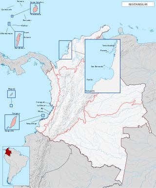
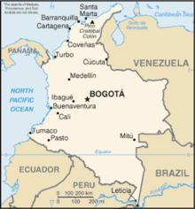
The insular region of Colombia includes the oceanic islands outside the continental territory. In the Caribbean this includes the San Andrés and Providencia islands near Central America and the many coastal islands along mainland Colombia. In the Pacific, it includes Gorgona Island and Malpelo Island. The ecosystems and wildlife found on these islands are the same as those found on their adjacent mainland areas. For example, the terrestrial habitat on Gorgona Island is tropical rainforest, similar to what is found in the Pacific lowlands of mainland Colombia.

Gordon Island is an island in the Tierra del Fuego archipelago located between the Tierra del Fuego and the Hoste Island. It divides the Beagle Channel in two arms, the Northwest arm or Pomar Channel and the Southwest arm.
The Colorados Archipelago is a chain of isles and cays on Cuba's north-western coast.
The region of the Beagle Channel, explored by Robert FitzRoy in the 1830s, was one of the last to be colonized by Chile and Argentina. The cold weather, the long distances from other inhabited regions, and the shortage of transport and subsistence, kept it far from the governmental task.
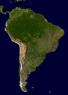
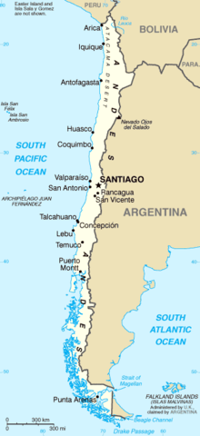
The islands of Chile encompass the various islands that the government of Chile has sovereignty over. By far the majority of these are the islands in the south of the country. Chile has one of the world's longest coastlines, and one of the most dangerous for boats; it is more than 4,000 kilometres (2,500 mi) long and has at least 43,471 islands.
The southern coast of Chile presents a large number of fjords and fjord-like channels from the latitudes of Cape Horn to Reloncaví Estuary. Some fjords and channels are important navigable channels providing access to ports like Punta Arenas, Puerto Chacabuco and Puerto Natales.

The Archipelago of San Bernardo is a set of nine coastal coral islands and one artificial island belonging to and governed by Colombia, located in the Gulf of Morrosquillo in the Caribbean Sea, with an approximate area of 213 km2. Administratively, the archipelago belongs to the Bolívar Department, with the exception of Boquerón Island, which belongs to the Sucre Department. It consists of Boquerón Island, Cabruna Island, Ceycén Island, Mangle Island, Múcura Island, Palma Island, Panda Island, Santa Cruz del Islote, Tintipán Island and Maravilla Island. All the 10 islands are close to the towns of Tolú and Coveñas.