List of lakes of Puerto Rico

Last updated

This is a list of lakes in Puerto Rico.

Puerto Rico is an archipelago composed by an eponymous main island, the isle municipalities of Vieques and Culebra, as well as several cays.

Contents

LakeSurface AreaMaximum DepthElevationCoordinatesMunicipality
Baño Grande Pool 2,110 feet (640 m) 18°18′06″N65°47′07″W / 18.301620°N 65.785163°W / 18.301620; -65.785163 Río Grande [1]
Boca de la Zanja Aguada [2]
Caño Boquerón 13 feet (4.0 m) 18°00′28″N67°10′26″W / 18.007741°N 67.173790°W / 18.007741; -67.173790 Cabo Rojo [3]
Charco Azul 1,998 feet (609 m) 18°05′29″N66°01′52″W / 18.091351°N 66.030998°W / 18.091351; -66.030998 Patillas [4]
El Salto 551 feet (168 m) 18°23′28″N66°27′12″W / 18.39106°N 66.453226°W / 18.39106; -66.453226 Manatí [5]
Lasen el sector de Joyuda Damas Pool 564 feet (172 m) 18°19′27″N65°44′32″W / 18.32412°N 65.742107°W / 18.32412; -65.742107 Luquillo [6]
Lago Bronce 167 feet (51 m) 18°01′42″N66°34′08″W / 18.028298°N 66.568784°W / 18.028298; -66.568784 Ponce [7]
Lago Guayabal 103.94 metres (341.0 ft) Villalba [8]
Lago Gely 203 feet (62 m) 18°02′50″N66°34′19″W / 18.047186°N 66.571839°W / 18.047186; -66.571839 Ponce [9]
Lago Giles 312 feet (95 m) 18°02′19″N66°33′54″W / 18.038575°N 66.564895°W / 18.038575; -66.564895 Ponce [10]
Lago Managua 13 feet (4.0 m) 18°26′03″N65°58′41″W / 18.434113°N 65.977943°W / 18.434113; -65.977943 Carolina [11]
Lago Ponceña 246 feet (75 m) 18°03′25″N66°32′27″W / 18.056908°N 66.540728°W / 18.056908; -66.540728 Juana Díaz [12]
Lago Vista Alegre 312 feet (95 m) 18°03′57″N66°33′10″W / 18.065796°N 66.552673°W / 18.065796; -66.552673 Ponce [13]
Lagos de Levitttown 16 feet (4.9 m) 18°27′34″N66°11′37″W / 18.45939°N 66.193501°W / 18.45939; -66.193501 Bayamón [14]
Laguna Aguas Prietas 13 feet (4.0 m) 18°22′14″N65°38′38″W / 18.370507°N 65.643773°W / 18.370507; -65.643773 Fajardo [15]
Laguna Algodones 36 feet (11 m) 18°09′22″N65°22′26″W / 18.156074°N 65.373769°W / 18.156074; -65.373769 Vieques [16]
Laguna Anones 10 feet (3.0 m) 18°08′15″N65°17′49″W / 18.137463°N 65.296824°W / 18.137463; -65.296824 Vieques [17]
Laguna Arenas 36 feet (11 m) 18°06′58″N65°34′15″W / 18.116074°N 65.570716°W / 18.116074; -65.570716 Vieques [18]
Laguna Atolladero 3 feet (0.91 m) 18°07′54″N67°11′02″W / 18.131624°N 67.183791°W / 18.131624; -67.183791 Cabo Rojo [19]
Laguna Bocanasilla 7 feet (2.1 m) 18°09′11″N67°09′54″W / 18.153012°N 67.164902°W / 18.153012; -67.164902 Cabo Rojo [20]
Laguna Cartagena 33 feet (10 m) 18°00′50″N67°06′04″W / 18.013852°N 67.101012°W / 18.013852; -67.101012 Lajas [21]
Laguna El Pobre 10 feet (3.0 m) 18°07′09″N65°33′46″W / 18.119129°N 65.562660°W / 18.119129; -65.562660 Vieques [22]
Laguna Grande 10 feet (3.0 m) 18°22′35″N65°37′24″W / 18.376340°N 65.623217°W / 18.376340; -65.623217 Fajardo [23]
Laguna Guaniquilla 0 feet (0 m) 18°02′15″N67°12′07″W / 18.037462°N 67.201847°W / 18.037462; -67.201847 Cabo Rojo [24]
Laguna Joyuda 339 acres (137 ha)3 feet (0.91 m) 18°07′50″N67°10′38″W / 18.130513°N 67.177124°W / 18.130513; -67.177124 Cabo Rojo [25]
Laguna Kiani 0 feet (0 m) 18°06′53″N65°33′41″W / 18.114685°N 65.561271°W / 18.114685; -65.561271 Vieques [26]
Laguna La Plata 10 feet (3.0 m) 18°07′10″N65°22′41″W / 18.119409°N 65.377936°W / 18.119409; -65.377936 Vieques [27]
Laguna La Torrecilla 16 feet (4.9 m) 18°26′38″N65°58′59″W / 18.443835°N 65.982943°W / 18.443835; -65.982943 Loíza, Carolina [28]
Laguna Lobina 10 feet (3.0 m) 18°18′05″N65°18′03″W / 18.301345°N 65.300714°W / 18.301345; -65.300714 Culebra [29]
Laguna Los Corozos 0 feet (0 m) 18°26′23″N66°02′19″W / 18.439668°N 66.038499°W / 18.439668; -66.038499 San Juan, Carolina [30]
Laguna Mata Redonda 3 feet (0.91 m) 18°28′27″N66°18′39″W / 18.474112°N 66.310725°W / 18.474112; -66.310725 Dorado [31]
Laguna Matías 3 feet (0.91 m) 18°07′30″N65°19′45″W / 18.124964°N 65.329047°W / 18.124964; -65.329047 Vieques [32]
Laguna Monte Largo 10 feet (3.0 m) 18°09′11″N65°21′47″W / 18.153018°N 65.362936°W / 18.153018; -65.362936 Vieques [33]
Laguna Playa Grande 0 feet (0 m) 18°05′24″N65°31′02″W / 18.089965°N 65.517104°W / 18.089965; -65.517104 Vieques [34]
Laguna Puerto Diablo 0 feet (0 m) 18°08′41″N65°19′56″W / 18.144685°N 65.332102°W / 18.144685; -65.332102 Vieques [35]
Laguna Rica 23 feet (7.0 m) 18°27′07″N66°25′36″W / 18.451891°N 66.426559°W / 18.451891; -66.426559 Vega Baja [36]
Laguna San José 0 feet (0 m) 18°25′30″N66°01′30″W / 18.424947°N 66.024888°W / 18.424947; -66.024888 Carolina [37]
Laguna Tortuguero 600 acres (240 ha)3 feet (0.91 m) 18°27′48″N66°26′29″W / 18.463279°N 66.441282°W / 18.463279; -66.441282 Manatí, Vega Baja [38]
Laguna Yanuel 3 feet (0.91 m) 18°07′37″N65°22′20″W / 18.126908°N 65.372102°W / 18.126908; -65.372102 Vieques [39]
Laguna Zoní 26,731 m²10 feet (3.0 m) 18°19′13″N65°15′34″W / 18.320234°N 65.259323°W / 18.320234; -65.259323 Culebra [40]
Laguna de Cornelio 13 feet (4.0 m) 18°18′38″N65°18′54″W / 18.310512°N 65.314881°W / 18.310512; -65.314881 Culebra [41]
Laguna de Lobine 10 feet (3.0 m) 18°18′05″N65°18′04″W / 18.301345°N 65.300991°W / 18.301345; -65.300991 Culebra [42]
Laguna de Molino 0 feet (0 m) 18°19′13″N65°14′14″W / 18.320234°N 65.237101°W / 18.320234; -65.237101 Culebra [43]
Laguna de Pinoñes 3 feet (0.91 m) 18°26′18″N65°57′12″W / 18.438279°N 65.953221°W / 18.438279; -65.953221 Loíza [44]
Laguna de Puerto Nuevo 10 feet (3.0 m) 18°28′59″N66°24′27″W / 18.483000°N 66.407392°W / 18.483000; -66.407392 Vega Baja [45]
Laguna de las Salinas 0 feet (0 m) 17°58′17″N66°40′10″W / 17.971356°N 66.669340°W / 17.971356; -66.669340 Ponce [46]
Laguna del Condado 0 feet (0 m) 18°27′30″N66°04′48″W / 18.458279°N 66.079888°W / 18.458279; -66.079888 San Juan [47]
Laguna del Flamenco 278,387 m²10 feet (3.0 m) 18°19′28″N65°18′59″W / 18.324400°N 65.31627°W / 18.324400; -65.31627 Culebra [48]
Mar Negro3 feet (0.91 m) 17°56′43″N66°15′36″W / 17.945245°N 66.259890°W / 17.945245; -66.259890 Salinas [49]
Pozo Del Rey 413 feet (126 m) 18°28′01″N66°56′07″W / 18.466889°N 66.935179°W / 18.466889; -66.935179 Quebradillas [50]

See also

Related Research Articles

Trujillo Alto, Puerto Rico Town and municipality in Puerto Rico

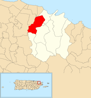
Trujillo Alto is a town and municipality of Puerto Rico located in the Northern Coastal Plain, on the boundary between the karst zone and Sierra de Luquillo, north of Caguas, and Gurabo; southeast of San Juan, and west of Carolina. Trujillo Alto is part of the San Juan Metropolitan Area, which includes the municipalities of Bayamón, Guaynabo, Cataño, and Toa Baja. The city is spread over 6 barrios and Trujillo Alto Pueblo. It is part of the San Juan-Caguas-Guaynabo Metropolitan Statistical Area.

Cordillera Central (Puerto Rico) Mountain range in Puerto Rico

Cordillera Central, is the main mountain range in Puerto Rico. The range crosses the island from west to east and divides it into its northern and southern coastal plains. The Cordillera Central runs eastward from the municipality of Maricao in the west to Aibonito in the central eastern region, and on to the Caribbean in the southeast through the Sierra de Cayey. The Central Mountain Range consists of the Cordillera Central proper and numerous subranges, foothills and ridges that extend throughout the island. Cerro de Punta is both the highest peak of the Cordillera Central and the highest point in Puerto Rico. The Sierra de Luquillo, where El Yunque is located, is sometimes included as a subrange or eastward extension of the Cordillera Central.

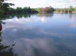
Lago Carite is a lake located in the municipality of Guayama on the island of Puerto Rico. The lake was created in 1913 and serves as a reservoir for irrigation and potable water.

Boquerón, Cabo Rojo, Puerto Rico Barrio of Puerto Rico

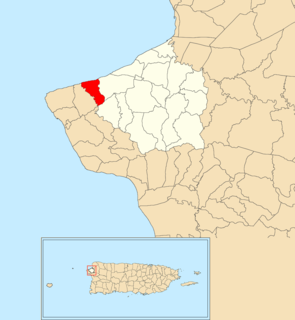
Boquerón is a barrio in the municipality of Cabo Rojo, Puerto Rico. Its population in 2010 was 5,373. The village of Boquerón, located on the Boquerón Bay is one of the main tourist attractions in the southwestern part of the island. In 2000, its population was 4,963.

Cerrillos, Ponce, Puerto Rico Barrio of Puerto Rico

Cerrillos is one of the 31 barrios of the municipality of Ponce, Puerto Rico. Along with Magueyes, Tibes, Portugués, Montes Llanos, Maragüez, and Machuelo Arriba, Cerrillos is one of the municipality's seven interior rural barrios. It was founded in 1878.

Real, Ponce, Puerto Rico Barrio of Puerto Rico

Real is one of the 31 barrios of the municipality of Ponce, Puerto Rico. Along with Anón, Coto Laurel, Guaraguao, Quebrada Limón, Marueño, and San Patricio, and the coastal barrios of Canas and Capitanejo, Real is one of the municipality's nine bordering barrios. It borders the municipality of Juana Diaz. It was founded in 1878.

Guanajibo, Cabo Rojo, Puerto Rico Barrio of Puerto Rico

Guanajibo is a barrio in the municipality of Cabo Rojo, Puerto Rico. Its population in 2010 was 4,905.

Quebrada Grande, Barranquitas, Puerto Rico Barrio of Puerto Rico

Quebrada Grande is a barrio in the municipality of Barranquitas, Puerto Rico. Its population in 2010 was 3,217.

Cerrote Barrio of Las Marías, Puerto Rico

Cerrote Barrio is a barrio in the municipality of Las Marías, Puerto Rico. Its population in 2010 was 496.

Monte Grande, Cabo Rojo, Puerto Rico Barrio of Puerto Rico

Monte Grande is a barrio in the municipality of Cabo Rojo, Puerto Rico. Its population in 2010 was 7,227.

Playa Sardinas II Barrio of Culebra, Puerto Rico

Playa Sardinas II is a barrio in the municipality of Culebra, Puerto Rico. Its population in 2010 was 64.

Guerrero, Aguadilla, Puerto Rico Barrio of Puerto Rico

Guerrero is a rural barrio in the municipality of Aguadilla, Puerto Rico. Its population in 2010 was 3,406. In Guerrero barrio is Rafael Hernández, a comunidad.

Río Grande, Aguada, Puerto Rico Barrio of Puerto Rico

Río Grande is a barrio in the municipality of Aguada, Puerto Rico. Its population in 2010 was 1,152.

Carraízo Barrio of Trujillo Alto, Puerto Rico

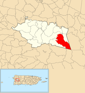
Carraízo is a barrio in the municipality of Trujillo Alto, Puerto Rico. Its population in 2010 was 16,399.

Zarzal, Río Grande, Puerto Rico Barrio of Puerto Rico

Zarzal is a barrio in the municipality of Río Grande, Puerto Rico. Its population in 2010 was 14,314.

Lagunas, Aguada, Puerto Rico Barrio of Puerto Rico

Lagunas is a barrio in the municipality of Aguada, Puerto Rico. Its population in 2010 was 2,810.

Ciénaga Baja Barrio of Río Grande, Puerto Rico

Ciénaga Baja is a barrio in the municipality of Río Grande, Puerto Rico. Its population in 2010 was 18,385.

Cerro del Vigía Foothill in Ponce, Puerto Rico

Cerro del Vigía is a hill in the municipality of Ponce, Puerto Rico, located just north of the city of Ponce. A tourist destination, it is home to Museo Castillo Serrallés, Cruceta del Vigía, and the former Hotel Ponce Intercontinental.

Cerro del Diablo Foothill in Ponce, Puerto Rico, United States

Cerro del Diablo is a mountain in the municipality of Ponce, Puerto Rico, located north-northwest of the city of Ponce. The 2,234-foot high hill sits at the foothills of the Cordillera Central and is located in Barrio Tibes.

References

  1. "Bano Grade Pool". Geographic Names Information System . United States Geological Survey . Retrieved 2009-05-04.
  2. "Boca de La Zanja". Geographic Names Information System . United States Geological Survey . Retrieved 2009-05-04.
  3. "Caño Boquernón". Geographic Names Information System . United States Geological Survey . Retrieved 2009-05-04.
  4. "Charco Azul". Geographic Names Information System . United States Geological Survey . Retrieved 2009-05-04.
  5. "El Salto". Geographic Names Information System . United States Geological Survey . Retrieved 2009-05-04.
  6. "La Damas Pool". Geographic Names Information System . United States Geological Survey . Retrieved 2009-05-04.
  7. "Lago Bronce". Geographic Names Information System . United States Geological Survey . Retrieved 2009-05-04.
  8. "Sedimentation History of Lago Guayabal, Puerto Rico, 1913-2001" (PDF). usgs. U.S. Department of the Interior U.S. Geological Survey - Prepared in cooperation with the PUERTO RICO ELECTRIC POWER AUTHORITY. Retrieved 7 September 2020.
  9. "Lago Gely". Geographic Names Information System . United States Geological Survey . Retrieved 2009-05-04.
  10. "Lago Giles". Geographic Names Information System . United States Geological Survey . Retrieved 2009-05-04.
  11. "Lago Managua". Geographic Names Information System . United States Geological Survey . Retrieved 2009-05-04.
  12. "Lago Ponceña". Geographic Names Information System . United States Geological Survey . Retrieved 2009-05-04.
  13. "Lago Vista Alegre". Geographic Names Information System . United States Geological Survey . Retrieved 2009-05-04.
  14. "Lagos de Levitttown". Geographic Names Information System . United States Geological Survey . Retrieved 2009-05-04.
  15. "Laguna Aguas Prietas". Geographic Names Information System . United States Geological Survey . Retrieved 2009-05-04.
  16. "Laguna Algodones". Geographic Names Information System . United States Geological Survey . Retrieved 2009-05-04.
  17. "Laguna Anones". Geographic Names Information System . United States Geological Survey . Retrieved 2009-05-04.
  18. "Laguna Arenas". Geographic Names Information System . United States Geological Survey . Retrieved 2009-05-04.
  19. "Laguna Atolladero". Geographic Names Information System . United States Geological Survey . Retrieved 2009-05-04.
  20. "Laguna Bocanasilla". Geographic Names Information System . United States Geological Survey . Retrieved 2009-05-04.
  21. "Laguna Cartagena". Geographic Names Information System . United States Geological Survey . Retrieved 2009-05-04.
  22. "Laguna El Pobre". Geographic Names Information System . United States Geological Survey . Retrieved 2009-05-04.
  23. "Laguna Grande". Geographic Names Information System . United States Geological Survey . Retrieved 2009-05-04.
  24. "Laguna Guaniquilla". Geographic Names Information System . United States Geological Survey . Retrieved 2009-05-04.
  25. "Laguna Joyuda". Geographic Names Information System . United States Geological Survey . Retrieved 2009-05-04.
  26. "Laguna Kiani". Geographic Names Information System . United States Geological Survey . Retrieved 2009-05-04.
  27. "Laguna La Plata". Geographic Names Information System . United States Geological Survey . Retrieved 2009-05-04.
  28. "Laguna La Torrecilla". Geographic Names Information System . United States Geological Survey . Retrieved 2009-05-04.
  29. "Laguna Lobina". Geographic Names Information System . United States Geological Survey . Retrieved 2009-05-04.
  30. "Laguna Los Corozos". Geographic Names Information System . United States Geological Survey . Retrieved 2009-05-04.
  31. "Laguna Mata Redonda". Geographic Names Information System . United States Geological Survey . Retrieved 2009-05-04.
  32. "Laguna Matías". Geographic Names Information System . United States Geological Survey . Retrieved 2009-05-04.
  33. "Laguna Monte Largo". Geographic Names Information System . United States Geological Survey . Retrieved 2009-05-04.
  34. "Laguna Playa Grande". Geographic Names Information System . United States Geological Survey . Retrieved 2009-05-04.
  35. "Laguna Puerto Diablo". Geographic Names Information System . United States Geological Survey . Retrieved 2009-05-04.
  36. "Laguna Rica". Geographic Names Information System . United States Geological Survey . Retrieved 2009-05-04.
  37. "Laguna San José". Geographic Names Information System . United States Geological Survey . Retrieved 2009-05-04.
  38. "Laguna Tortuguero". Geographic Names Information System . United States Geological Survey . Retrieved 2009-05-04.
  39. "Laguna Yanuel". Geographic Names Information System . United States Geological Survey . Retrieved 2009-05-04.
  40. "Laguna Zoní". Geographic Names Information System . United States Geological Survey . Retrieved 2009-05-04.
  41. "Laguna de Cornelio". Geographic Names Information System . United States Geological Survey . Retrieved 2009-05-04.
  42. "Laguna de Lobine". Geographic Names Information System . United States Geological Survey . Retrieved 2009-05-04.
  43. "Laguna de Molino". Geographic Names Information System . United States Geological Survey . Retrieved 2009-05-04.
  44. "Laguna de Pinoñes". Geographic Names Information System . United States Geological Survey . Retrieved 2009-05-04.
  45. "Laguna de Puerto Nuevo". Geographic Names Information System . United States Geological Survey . Retrieved 2009-05-04.
  46. "Laguna de las Salinas". Geographic Names Information System . United States Geological Survey . Retrieved 2009-05-04.
  47. "Laguna del Condado". Geographic Names Information System . United States Geological Survey . Retrieved 2009-05-04.
  48. "Laguna del Flamenco". Geographic Names Information System . United States Geological Survey . Retrieved 2009-05-04.
  49. "Mar Negro". Geographic Names Information System . United States Geological Survey . Retrieved 2009-05-04.
  50. "Pozo Del Rey". Geographic Names Information System . United States Geological Survey . Retrieved 2009-05-04.