

There are both state and federal marine protected areas of the Hawaiian archipelago. The state protected areas, called Marine Life Conservation Districts, are managed by the State of Hawai'i Division of Aquatic Resources. [1]
There are both state and federal marine protected areas of the Hawaiian archipelago. The state protected areas, called Marine Life Conservation Districts, are managed by the State of Hawai'i Division of Aquatic Resources. [1]

Kihei is a census-designated place (CDP) in Maui County, Hawaii, United States. The population was 21,423 at the 2020 census.

Kahoʻolawe, anglicized as Kahoolawe, is the smallest of the eight main volcanic islands in the Hawaiian Islands. Kahoʻolawe is about seven miles (11 km) southwest of Maui and also southeast of Lānaʻi, and it is 11 mi (18 km) long by 6.0 mi (9.7 km) wide, with a total land area of 44.97 sq mi (116.47 km2). The highest point on Kahoʻolawe is the crater of Lua Makika, at the summit of Puʻu Moaulanui, about 1,477 feet (450 m) above sea level. Kahoʻolawe is relatively dry because the island's low elevation fails to generate much orographic precipitation from the northeastern trade winds, and Kahoʻolawe is in the rain shadow of eastern Maui's 10,023-foot-high (3,055 m) volcano, Haleakalā. More than one quarter of Kahoʻolawe has been eroded down to saprolitic hardpan soil, largely on exposed surfaces near the summit.

Makapuʻu is the extreme eastern end of the Island of Oʻahu in the Hawaiian Islands, comprising the remnant of a ridge that rises 647 feet (197 m) above the sea. The cliff at Makapuʻu Point forms the eastern tip and is the site of a prominent lighthouse. The place name of this area, meaning "bulging eye" in Hawaiian, is thought to derive from the name of an image said to have been located in a cave here called Keanaokeakuapōloli. The entire area is quite scenic and a panoramic view is presented at the lookout on Kalanianaole Highway where the roadway surmounts the cliff just before turning south towards leeward Oʻahu and Honolulu.
The following is an alphabetical list of articles related to the U.S. state of Hawaii:

The Hawaii State Department of Education (HIDOE) is a statewide public education system in the United States. The school district can be thought of as analogous to the school districts of other cities and communities in the United States, but in some manners can also be thought of as analogous to the state education agencies of other states. As the official state education agency, the Hawaiʻi State Department of Education oversees all 283 public schools and charter schools and over 13,000 teachers in the State of Hawaiʻi. It serves approximately 185,000 students annually. The HIDOE is currently headed by Superintendent Keith Hayashi. The department is headquartered in the Queen Liliuokalani Building in Honolulu CDP, City and County of Honolulu on the island of Oahu.

Hanauma is a marine embayment formed within a tuff ring and located along the southeast coast of the Island of Oʻahu in the Hawaii Kai neighborhood of East Honolulu, in the Hawaiian Islands.

Kealakekua Bay is located on the Kona coast of the island of Hawaiʻi about 12 miles (19 km) south of Kailua-Kona. Settled over a thousand years ago, the surrounding area contains many archeological and historical sites such as religious temples (heiaus) and also includes the spot where the first documented European to reach the Hawaiian islands, Captain James Cook, was killed. It was listed in the National Register of Historic Places listings on the island of Hawaii in 1973 as the Kealakekua Bay Historical District. The bay is a marine life conservation district, a popular destination for kayaking, scuba diving, and snorkeling.
A U.S. National Marine Sanctuary is a zone within United States waters where the marine environment enjoys special protection. The program began in 1972 in response to public concern about the plight of marine ecosystems.

The National Tropical Botanical Garden (NTBG) is a Hawaii-based not-for-profit institution dedicated to tropical plant research, conservation, and education. It operates a network of botanical gardens and preserves in Hawaii and Florida.

The Hawaii Department of Land and Natural Resources (DLNR) is a part of the Hawaii state government dedicated to managing, administering, and exercising control over public lands, water resources and streams, ocean waters, coastal areas, minerals, and other natural resources of the State of Hawaiʻi. The mission of the Hawaiʻi Department of Land and Natural Resources is to "enhance, protect, conserve and manage Hawaiʻi's unique and limited natural, cultural and historic resources held in public trust for current and future generations of the people of Hawaiʻi nei, and its visitors, in partnership with others from the public and private sectors." The organization oversees over 1.3 million acres of land, beaches, and coastal waters and 750 miles of coastal land.

Honolua Bay, Mokuleʻia Bay and Lipoa Point are part of an area known as the ahupuaʻa of Honolua, located just north of Kapalua, West Maui in Maui County, Hawaiʻi, United States. The area is a mix of agricultural and conservation land tended by the Maui Land & Pineapple Company in Lahaina, Hawaiʻi, including coastline management. Honolua Bay and Mokuleʻia Bay comprise the 45-acre (18 ha) Honolua-Mokuleʻia Marine Life Conservation District.
The South Maui Coastal Heritage Corridor is a recreation and tourism project of the Tri-Isle Resource Conservation and Development Council. The non-profit council partners with the Natural Resources Conservation Service of the United States Department of Agriculture. The project is managed by a committee chairperson in cooperation with the Hawaii Department of Land and Natural Resources, Division of Forestry and Wildlife, Na Ala Hele Trails and Access Program, U.S. Fish and Wildlife Service, University of Hawaii, Sea Grant Extension Service, and individuals from the community of Kihei. The project protects and provides public access to South Maui's 15 mile leeward coastline.
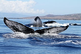
The Hawaiian Islands Humpback Whale National Marine Sanctuary is one of the world's most important whale habitats, hosting thousands of humpbacks each winter.

Old Kona Airport State Recreation Area is a park built on the site of an old landing strip just north of Kailua, Hawaii County, Hawaii.
Established in 1973, ʻĀhihi-Kīnaʻu Natural Area Reserve includes a coastal lava field and surrounding waters on the southwest coast of the island of Maui, Hawaii. It consists of 1,238 acres (501 ha) on land and 807 acres (327 ha) of ocean along 3 miles (4.8 km) of Maui's southwestern coastline. The reserve includes several popular snorkeling/diving sites and many cultural and geologic sites as well as habitat for numerous rare and endangered species. The purpose and intent of the Reserve is to preserve and protect three unique components: the geologic setting of the most recent lava flow on Maui; unique assemblages of nearshore coral reef ecosystems; and the anchialine ponds found there.

Molokini is a crescent-shaped, partially submerged volcanic crater which forms a small, uninhabited islet located in ʻAlalākeiki Channel between the islands of Maui and Kahoʻolawe, within Maui County in Hawaiʻi. It is the remains of one of the seven Pleistocene epoch volcanoes that formed the prehistoric Maui Nui island, during the Quaternary Period of the Cenozoic Era.

The Hawaii Division of Conservation and Resources Enforcement (DOCARE) and also known as the Hawaii DLNR Police, is the law enforcement agency for the Hawaii Department of Land and Natural Resources. It is tasked with full state police powers to enforces all State laws and Department rules, with primary jurisdiction involving State lands, State Parks, historical sites, forest reserves, aquatic life and wildlife areas, coastal zones, Conservation districts, State shores, as well as county ordinances involving county parks, for enforcing Hawaii's fishing and recreational boating laws and protecting reefs and other marine resources, patrolling harbors and coastal areas, and conducting marijuana eradication missions.

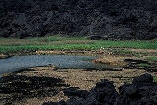
Kīholo Bay is located in the ahupua`a of Pu`u Wa`awa`a in the North Kona District on the Big Island of Hawaii. the land surrounding the bay is flanked to the South by a lava flow from Mount Hualalai ca. 1801 and another flow from Mauna Loa in 1859. The land surrounding Kīholo Bay is under the authority of Hawai‘i State Parks. Approximately 2 miles long (3.2 km), it is one of the island's largest bays. Kīholo Bay is now a popular site for tourists and nature enthusiasts.