
This is a list of marine protected areas of the U.S. state of Oregon. The state marine reserves are managed by the Oregon Department of Fish and Wildlife. [1]
This is a list of marine protected areas of the U.S. state of Oregon. The state marine reserves are managed by the Oregon Department of Fish and Wildlife. [1]

Protected areas of South Australia consists of protected areas located within South Australia and its immediate onshore waters and which are managed by South Australian Government agencies. As of March 2018, South Australia contains 359 separate protected areas declared under the National Parks and Wildlife Act 1972, the Crown Land Management Act 2009 and the Wilderness Protection Act 1992 which have a total land area of 211,387.48 km2 (81,617.16 sq mi) or 21.5% of the state's area.

The protected areas of the United States are managed by an array of different federal, state, tribal and local level authorities and receive widely varying levels of protection. Some areas are managed as wilderness, while others are operated with acceptable commercial exploitation. As of 2022, the 42,826 protected areas covered 1,235,486 km2 (477,024 sq mi), or 13 percent of the land area of the United States. This is also one-tenth of the protected land area of the world. The U.S. also had a total of 871 National Marine Protected Areas, covering an additional 1,636,523 km2 (631,865 sq mi), or 19 percent of the total marine area of the United States.

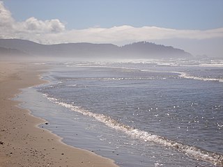
Oswald West State Park is part of the state park system of the U.S. state of Oregon. It is located about 10 miles (16 km) south of the city of Cannon Beach, adjacent to Arch Cape, on the Pacific Ocean. The park covers 2,448 acres (9.91 km2), with many miles of hiking trails both inside the park grounds and linking to other parks and landmarks beyond.

The California Department of Fish and Wildlife (CDFW), formerly known as the California Department of Fish and Game (CDFG), is a state agency under the California Natural Resources Agency. The Department of Fish and Wildlife manages and protects the state's wildlife, wildflowers, trees, mushrooms, algae (kelp) and native habitats (ecosystems). The department is responsible for regulatory enforcement and management of related recreational, commercial, scientific, and educational uses. The department also prevents illegal poaching.
The Oregon Department of Fish and Wildlife (ODFW) is a government agency of the U.S. state of Oregon responsible for programs protecting Oregon fish and wildlife resources and their habitats. The agency operates hatcheries, issues hunting and angling licenses, advises on habitat protection, and sponsors public education programs. Its history dates to the 1878 establishment of the office of Columbia River Fish Warden. Since 1931, enforcement of Oregon's Fish and Game laws has been the responsibility of the Oregon State Police rather than separate wardens.
The Oregon Coast National Wildlife Refuge Complex consists of six National Wildlife Refuges along the Oregon Coast. It provides wilderness protection to thousands of small islands, rocks, reefs, headlands, marshes, and bays totaling 371 acres spanning 320 miles (515 km) of Oregon's coastline. The areas are all managed by the United States Fish and Wildlife Service.

Oregon Islands National Wildlife Refuge is a U.S. National Wildlife Refuge off the southwestern Oregon Coast. It is one of six National Wildlife Refuges comprising the Oregon Coast National Wildlife Refuge Complex. The Oregon Islands provides wilderness protection to 1,853 small islands, rocks, and reefs plus two headlands, totaling 371 acres (150 ha) spanning 1,083 acres (438 ha) of Oregon's coastline from the Oregon–California border to Tillamook Head. There are sites in six of the seven coastal counties of Oregon. From north to south they are Clatsop, Tillamook, Lincoln, Lane, Coos, and Curry counties. The area is managed by the United States Fish and Wildlife Service.
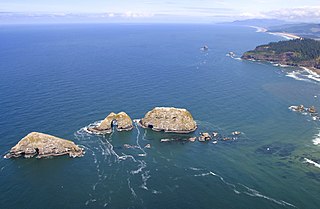
Three Arch Rocks National Wildlife Refuge is a U.S. National Wildlife Refuge off the northern Oregon Coast. It is located on the central coast of Tillamook County, in the northwestern part of Oregon. It is one of six National Wildlife Refuges within the Oregon Coast National Wildlife Refuge Complex and was the first National Wildlife Refuge west of the Mississippi River. In 1970 the Refuge was designated as wilderness. It is one of the smallest wilderness areas in the United States.
Cape Meares National Wildlife Refuge is a National Wildlife Refuge of the Oregon Coast. It is one of six National Wildlife Refuges in the Oregon Coast National Wildlife Refuge Complex. Located on Cape Meares, the refuge was established in 1938 to protect a remnant of coastal old-growth forest and the surrounding habitat used by breeding seabirds. The area provides a home for a threatened bird species, the marbled murrelets. Peregrine falcons, once at the brink of extinction, have nested here since 1987. The refuge, with the exception of the Oregon Coast Trail, was designated a Research Natural Area in 1987.

Asilomar State Marine Reserve (SMR) is one of four small marine protected areas (MPAs) located near the cities of Monterey and Pacific Grove, at the southern end of Monterey Bay on California’s central coast. The four MPAs together encompass 2.96 square miles (7.7 km2). The SMR protects all marine life within its boundaries. Fishing and take of all living marine resources is prohibited.
Moro Cojo Estuary State Marine Reserve (SMR) is a marine protected area established to protect the wildlife and habitats in Moro Cojo Slough. Moro Cojo Slough is located inland from Monterey Bay on the central coast of California, directly south of the more widely known Elkhorn Slough. The area covers 0.46 square miles (1.2 km2). The SMR protects all marine life within its boundaries. Fishing and take of all living marine resources is prohibited.

Carmel Pinnacles State Marine Reserve (SMR) is a marine protected area in Carmel Bay including a unique underwater pinnacle formation with adjacent kelp forest, submarine canyon head, and surfgrass. Carmel Bay is adjacent to the city of Carmel-by-the-Sea and is near Monterey, on California's central coast.

Lovers Point State Marine Reserve (SMR) is one of four small marine protected areas located near the cities of Monterey and Pacific Grove, at the southern end of Monterey Bay on California’s central coast. The four MPAs together encompass 2.96 square miles (7.7 km2). The SMR protects all marine life within its boundaries. Fishing and take of all living marine resources is prohibited.

Pacific Grove Marine Gardens State Marine Conservation Area is one of four small marine protected areas located near the cities of Monterey and Pacific Grove, at the southern end of Monterey Bay on California’s central coast. The four MPAs together encompass 2.96 square miles (7.7 km2). Within the SMCA fishing and take of all living marine resources is prohibited except the recreational take of finfish and the commercial take of giant and bull kelp by hand under certain conditions. According to the Frommer's guide, the Marine Gardens area is "renowned for ocean views, flowers, and tide-pool seaweed beds."

White Rock (Cambria) State Marine Conservation Area (SMCA) is a marine protected area located off the coast of the city of Cambria, California on California’s central coast. The marine protected area covers 2.32 square miles (6.0 km2). Within the SMCA the take of all living marine resources is prohibited except the commercial take of giant kelp and bull kelp under certain conditions.
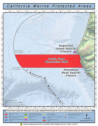
The South Cape Mendocino State Marine Reserve is an offshore marine protected area located off Cape Mendocino and the coastal town of Petrolia about 30 miles (48 km) south of Eureka. It marks California’s westernmost point. The area is one of the most undeveloped sections of the California coast, and its waters are homes to important bird and mammal species. Within the South Cape Mendocino State Marine Reserve, the take of all living marine resources is prohibited.

Sugar Loaf Island, also known as Sugar Loaf, Cape Rock, Sugarloaf Island, Sugar Loaf Rock, and Sugarloaf Rock Island is an island offshore Cape Mendocino in Humboldt County, California. It is the westernmost island in California