This is a list of towns and villages in the principal area of Rhondda Cynon Taf, Wales. Towns are highlighted in bold.
ŋ:Map of places in Rhondda Cynon Taf compiled from this list

Rhondda Cynon Taf is a county borough in the south-east of Wales. It consists of five valleys: the Rhondda Fawr, Rhondda Fach, Cynon, Taff and Ely valleys, plus a number of towns and villages away from the valleys.

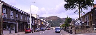
Cynon Valley is a former coal mining valley in Wales. It lies between Rhondda and the Merthyr Valley and takes its name from the River Cynon. Aberdare is located in the north of the valley and Mountain Ash in the south. From 1974 to 1996, Cynon Valley was a local government district.

Maerdy is a village and community in the county borough of Rhondda Cynon Taf, and within the historic county boundaries of Glamorgan, Wales, lying at the head of the Rhondda Fach Valley.

Ynysybwl is a village in Cwm Clydach in Wales. It is situated in the county borough of Rhondda Cynon Taf, roughly 15 miles (24 km) north-north-west of Cardiff, 4 miles (6 km) north of Pontypridd and 16 miles (26 km) south of Merthyr Tydfil, and forms part of the community of Ynysybwl and Coed-y-Cwm.
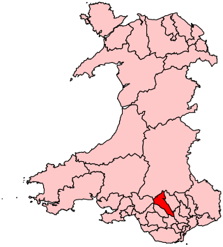
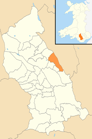
Cynon Valley is a constituency in Wales represented in the House of Commons of the UK Parliament since 2019 by Beth Winter of the Labour Party.

Rhondda was a local government district in the geographical area of the Rhondda Valley, south Wales, from 1877 until 1996, with various statuses through its history.
Treherbert is a village and community situated at the head of the Rhondda Fawr valley in the county borough of Rhondda Cynon Taf, Wales. Historically part of Glamorgan, Treherbert is a former industrial coal mining village which was at its economic peak between 1850 and 1920. Treherbert is the upper most community of the Rhondda Fawr and encompasses the districts of Blaencwm, Blaenrhondda, Tynewydd and Pen-yr-englyn.

Ton Pentre railway station is a railway station serving the village of Ton Pentre in Rhondda Cynon Taf, Wales. It is located on the Rhondda Line.

Rhigos is a small village on the saddle of higher ground between the Vale of Neath and the Cynon Valley. It was part of the old Neath Rural district Council under Glamorgan until 1974. The village then came under the jurisdiction of The Cynon Valley Borough which subsequently became Rhondda Cynon Taf, South Wales in 1996. It lies just off the old Aberdare road that was the main link between Aberdare and Glynneath, before the A465 road was extended in the 1960s. The hamlets of Cefn Rhigos and Cwm-Hwnt lie to the west of the main village.

Ton Pentre is a village in the Rhondda Valley in the county borough of Rhondda Cynon Taf, Wales. Historically part of Glamorgan, Ton Pentre, a former industrial coal mining village, is a district of the community of Pentre. The old district of Ystradyfodwg was named after the church at Ton Pentre. Ton Pentre is, perhaps, best known for an event in 1924, when the Duke of York played a round of golf with Trade Unionist Frank Hodges.
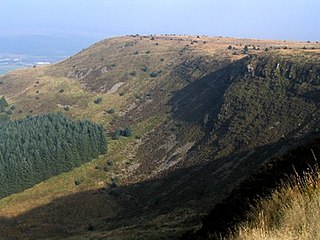
Craig y Llyn is a mountain situated to the south of the village of Rhigos in the Cynon Valley on the south side of the upper Vale of Neath and north of the Rhondda Valleys in South Wales; it is the highest point in the ancient kingdom and, later, county of Glamorgan (Morgannwg), and the southern Welsh coalfield plateau.

Rhondda Cynon Taf County Borough Council is the governing body for Rhondda Cynon Taf, one of the Principal Areas of Wales. The council headquarters are located in the community of Cwm Clydach on the outskirts of Tonypandy.
Pentre is a village, community and electoral ward near Treorchy in the Rhondda valley, falling within the county borough of Rhondda Cynon Taf, Wales. The village's name is taken from the Welsh word Pentref, which translates as homestead, though Pentre is named after a large farm that dominated the area before the coming of industrialisation. The community takes in the neighbouring village of Ton Pentre.
Hirwaun was a railway station serving the village of Hirwaun in Rhondda Cynon Taf, Wales.

Penderyn is a rural village in the Cynon Valley, Rhondda Cynon Taf, Wales, located near Hirwaun.
Hirwaun, Penderyn and Rhigos is the northernmost electoral ward in Rhondda Cynon Taf, Wales. It covers the communities of Hirwaun and Rhigos. The ward elects two county borough councillors to the Rhondda Cynon Taf County Borough Council. It is the largest ward in Rhondda Cynon Taf.
Mountain Ash East is a community and coterminous electoral ward in Rhondda Cynon Taf, Wales. It primarily includes the part of the town of Mountain Ash east of the River Cynon. The community was formed in 2016 when the larger community of Mountain Ash was divided into East and West to match the ward boundaries.
Pentrebach is a village in Merthyr Tydfil County Borough, Wales.
