List of rock formations in Bulgaria

Last updated

Geographic map of Bulgaria Bulgaria-geographic map-en.svg
Geographic map of Bulgaria

Bulgaria is a country in south-eastern Europe situated in the north-eastern part of the Balkan Peninsula. The country has a great variety of topographical features and diverse landscape ranging from the Alpine snow-capped peaks in Rila, Pirin and the Balkan Mountains to the mild and sunny Black Sea coast; from the typically continental Danubian Plain in the north to the strong Mediterranean climatic influence in the valleys of Macedonia and the lowlands in the southernmost parts of Thrace. The diverse morphological, climatic and hydrological conditions of Bulgaria [1] favour the formation of a large number of geological features.

Contents

Partial list of rock formations in Bulgaria

  Sites included in the 100 Tourist Sites of Bulgaria
NameImageDescriptionLocation within Bulgaria
Belintash Trakiisko svetilishche Belintash v Rodopite.JPG Belintash is a small plateau in the Rhodope Mountains bearing traces of human activity. The plateau is 750 m long, up to 50 m wide and 35 m high. It is assumed that Belintash was a cult site of the ancient Thracians, though the very essence and purpose are not yet fully understood. Belintash is situated near the village of Sini Vrah in Plovdiv Province. It was declared a natural landmark in 2013. [2]
Relief Map of Bulgaria.jpg
Red pog.svg
Belogradchik Rocks Belogradchishki skali 07.JPG Belogradchik Rocks are an extensive group of strange shaped sandstone and conglomerate rock formations located on the western slopes of the Balkan Mountains near the town of Belogradchik in Vidin Province. The rocks vary in colour from primarily red to yellow; some of the rocks reach up to 200 m in height. Many rocks have fantastic shapes and are associated with interesting legends. Belogradchik Rocks have been declared a natural landmark in 1949 and are a major tourist attraction in the region. They are included in the 100 Tourist Sites of Bulgaria under No. 15. [3]
Relief Map of Bulgaria.jpg
Red pog.svg
Bozhi Most Liliache-bojia-most-1.jpg Bozhi Most (God's Bridge) is a natural arch situated in a karst region in the western Balkan Mountains. Bozhi Most is 20 m high and 25 m wide. It was declared a natural landmark in 1964. It is situated in Vratsa Province between the villages Chiren and Lilyache. [4]
Relief Map of Bulgaria.jpg
Red pog.svg
Buynovo Gorge Buynovsko jdrelo 1.jpg Buynovsko Gorge is a narrow and steep canyon, up to 350 m deep and with a total length of 9,5 km. It is situated along the Byunovska River in the southern Rhodope Mountains between the village of Teshel and Yagodinska cave. There are numerous rock formations along the gorge, including four stone arches and 34 caves. It was declared a natural landmark in 1971. The gorge is included in the 100 Tourist Sites of Bulgaria under No. 89. [5] [6] [7]
Relief Map of Bulgaria.jpg
Red pog.svg
Chudnite Skali Bulgarian Wonder Rocks.jpg Chudnite Skali (The Wonderful Rocks) are situated on the banks of the Tsonevo Reservoir at a distance of 4 km from the village of Asparuhovo, Varna Province. Chudnite Skali are a massif of about ten rock needles, 40–50 meters high, shaped like castle towers. They were formed as a result of water and wind erosion on the local limestone rocks. [8] [9]
Relief Map of Bulgaria.jpg
Red pog.svg
Iskar Gorge Lakatnik IMG 1746.jpg Iskar Gorge is Bulgaria's longest and largest gorge with a total length of 67 km along the valley of Iskar River. The gorge passes through the Balkan Mountains and is situated between the town of Novi Iskar in Sofia City Province and the village of Lyutibrod in Vratsa Province. Along the densely wooded gorge are located a number of rock formations, caves and waterfalls, as well as monasteries and villa zones. [10]
Relief Map of Bulgaria.jpg
Red pog.svg
Kardzhali Earth Pyramids Kamenna svatba - The Groom and the Bride.jpg Kardzhali Earth Pyramids are a geomorphological structure in the eastern Rhodope Mountains formed 40 million years ago. The most recognizable rock formation is the Petrified Wedding near the village of Zimzelen, Kardzhali Province - a group of stone figures up to 10 m high that resemble people, animals and other shapes, centred around two rock formations resembling a groom and a bride. Kardzhali Earth Pyramids were declared a natural landmark in 1974. [11]
Relief Map of Bulgaria.jpg
Red pog.svg
Kominite Kominite.jpg Kominite (The Chimneys) are several andesite peaks in the Vitosha Mountains to the south of Bulgaria's capital Sofia. The peaks are situated in the upper valley of the Dragalevska River near the Bay Krastyo tourist site. The peaks are the nearest and most easily accessible climbing area to Sofia, with climbing routes of UIAA categories II to VIII. They are 50 to 100 m high. The most convenient access to Kominite is from Sofia's neighbourhood Dragalevtsi via Bay Krastyo or Goli Vrah chair lift stations. [12]
Relief Map of Bulgaria.jpg
Red pog.svg
Lakatnik Rocks Lakatnik IMG 1977.jpg Lakatnik Rocks are situated along the left slope of the Iskar Gorge in the western Balkan Mountains. They are located near the village of Milanovo, Sofia Province. The rocks are made of red sandstone and limestone. They are almost vertical and reach a height of up to 250 from the waters of the river Iskar. Lakatnik Rocks are situated in an extensive karst region and contain a number of caves. They were declared a natural landmark in 1966 and since 1989 are part of Vrachanski Balkan Nature Park. [13]
Relief Map of Bulgaria.jpg
Red pog.svg
Melnik Earth Pyramids Melnishkipiramidi.jpg Melnik Earth Pyramids are situated in the foothills of the Pirin Mountain in south-western Bulgaria, spanning an area of 17 km2 near Melnik, Karlanovo and Rozhen. Blagoevgrad Province. Reaching a height of up to 100 m these sandstone pyramids are shaped in forms, resembling giant mushrooms, ancient towers and obelisks. Melnik Earth Pyramids are a geological phenomenon of global importance and were declared a natural landmark in 1960. [14]
Relief Map of Bulgaria.jpg
Red pog.svg
Pobiti Kamani Pobitite kamyni.JPG Pobiti Kamani is a rock formation located in eastern Bulgaria near the town of Beloslav to the west of Varna. It consists of several groups of natural rock formations on a total area of 7 km2. The formations are mainly stone columns between 5 and 7 m high and from 0.3 to 3 m thick. The columns do not have solid foundations, but are instead hollow and filled with sand, and look like they are stuck into the surrounding sands, which gives the phenomenon its name. Pobiti Kamani was designated a natural landmark in 1937. [15]
Relief Map of Bulgaria.jpg
Red pog.svg
Ritlite Ritlite-3.jpg Ritlite are a group of limestone rock formations situated in the northern section of the Iskar Gorge on the right bank of the river Iskar near the village of Lyutibrod, Vratsa Province. The rocks reach a height of 80 m; they are 3 to 7 m thick and 200 to 400 m long. Ritlite were formed 120 million year ago. They were declared a natural landmark in 1938. [16]
Relief Map of Bulgaria.jpg
Red pog.svg
Stob Earth Pyramids 2010 Stob pyramids IMG 6048.jpg Stob Earth Pyramids are a set of earth pyramids located 7 km to the northeast of the village of Stob, Kyustendil Province. They are rock formations up to 12 m high and around 40 cm thick at the base. They vary in shape from sharp through conical to mushroomlike. Some of the columns are topped by flat stones. Groups of individual pyramids have been named the Towers, the Pinnacles and the Samodiva Chimneys. Stob Earth Pyramids were designated a natural landmark in 1964. [17]
Relief Map of Bulgaria.jpg
Red pog.svg
Stone Mushrooms Bulgaria-The Stone Mushrooms-03.jpg The Stone Mushrooms is a rock phenomenon near the village of Beli plast in Kardzhali Province, on the road between Haskovo and Kardzhali. They reach a height of about 2.5 - 3m. The Stone Mushrooms were designated a natural landmark in 1974. [18]
Relief Map of Bulgaria.jpg
Red pog.svg
Tran Gorge Jerma Bulgaria.JPG Tran Gorge is situated along the course of the river Erma in westernmost Bulgaria near the border with Serbia, at 3.5 km north of the town of Tran, Pernik Province. Its walls are almost vertical reaching a height of 120 m. It was declared a natural landmark in 1974. The gorge is included in the 100 Tourist Sites of Bulgaria under No. 39. [19] [20]
Relief Map of Bulgaria.jpg
Red pog.svg
Trigrad Gorge Trigrad gorge.jpg Trigrad Gorge is a canyon of vertical marble rocks in the western Rhodope Mountains. It is located at 1.2 km from the village of Trigrad, Smolyan Province. The gorge is 7 km long and follows the course of the Trigrad River, which plunges into the Devil's Throat Cave and 530 m further emerges as a large karst spring. The gorge's walls reach a height of up to 200 m. There are around 150 in the vicinity of the gorge which are important sanctuaries for bats. It was declared a natural landmark in 1963. The gorge is included in the 100 Tourist Sites of Bulgaria under No. 88. [21] [22]
Relief Map of Bulgaria.jpg
Red pog.svg
Wonderful Bridges Sl'nchevi l'chi.JPG The Wonderful Bridges are natural arches in the Rhodope Mountains of southern Bulgaria. They are located in the karst valley of the Erkyupriya river at an altitude of 1,450 m. There are two natural bridges. The larger is 15 m wide and 96 metres long, and consists of three vaulted arches, the largest of which is 45 metres high and 40 metres wide. The smaller bridge is located 200 m downstream. They were declared a natural landmark in 1961. The Wonderful Bridges are included in the 100 Tourist Sites of Bulgaria under No. 85. [23] [24]
Relief Map of Bulgaria.jpg
Red pog.svg
Zlatnite Mostove 12 Vitosha, Zlatnite mostove.JPG Zlatnite Mostove (The Golden Bridges) is the largest stone river in Vitosha Mountain. It is situated in the valley of Vladayska River, extending 2.2 km, and up to 150 m wide, with several ‘tributary’ stone rivers. The stone river is "descending" from an elevation of 1800 m above sea level to 1410 m. The lower reaches of the stone river is a popular tourist destination accessible from Sofia by road. The name Golden Bridges derives from the golden colour of the lichens growing on the surface of stone run boulders. [25]
Relief Map of Bulgaria.jpg
Red pog.svg

See also

Citations

  1. Donchev & Karakashev 2004 , p. 12
  2. "Belintash". Official Tourism Portal of Bulgaria. Retrieved 25 June 2015.
  3. "15. Belogradchik Rocks". Official Site of the 100 Tourist Sites of Bulgaria. Archived from the original on 7 May 2017. Retrieved 25 June 2015.
  4. "Bozhi Most". Register of the protected areas in Bulgaria. Retrieved 25 June 2015.
  5. "Buynovsko Gorge". Geologic phenomena of Bulgaria. Retrieved 25 June 2015.
  6. "89. Buynovsko Gorge". Official Site of the 100 Tourist Sites of Bulgaria. Retrieved 25 June 2015.
  7. "Buynovsko Gorge". Register of the protected areas in Bulgaria. Retrieved 25 June 2015.
  8. "Chudnite Skali". Geologic phenomena of Bulgaria. Retrieved 25 June 2015.
  9. "Chudnite Skali". Official Tourism Portal of Bulgaria. Retrieved 25 June 2015.
  10. "Iskar Gorge". Zone Bulgaria. Retrieved 25 June 2015.
  11. "Kardzhali Earth Pyramids". Geologic phenomena of Bulgaria. Retrieved 27 June 2015.
  12. "Kominite". Official Site of Vitosha Nature Park. Retrieved 27 June 2015.
  13. "Lakatnik Rocks". Geologic phenomena of Bulgaria. Retrieved 27 June 2015.
  14. "Melnik Earth Pyramids". Geologic phenomena of Bulgaria. Retrieved 27 June 2015.
  15. "Pobiti Kamani". Geologic phenomena of Bulgaria. Retrieved 27 June 2015.
  16. "Ritlite". Geologic phenomena of Bulgaria. Retrieved 27 June 2015.
  17. "Stob Earth Pyramids". Geologic phenomena of Bulgaria. Retrieved 27 June 2015.
  18. "The Stone Mushrooms". Register of the protected areas in Bulgaria. Retrieved 27 June 2015.
  19. "Tran Gorge". Geologic phenomena of Bulgaria. Retrieved 27 June 2015.
  20. "39. Tran Gorge". Official Site of the 100 Tourist Sites of Bulgaria. Retrieved 27 June 2015.
  21. "Trigrad Gorge". Geologic phenomena of Bulgaria. Retrieved 27 June 2015.
  22. "88. Trigrad Gorge". Official Site of the 100 Tourist Sites of Bulgaria. Retrieved 27 June 2015.
  23. "Wonderful Bridges". Geologic phenomena of Bulgaria. Retrieved 27 June 2015.
  24. "85. Wonderful Bridges". Official Site of the 100 Tourist Sites of Bulgaria. Archived from the original on 15 August 2016. Retrieved 27 June 2015.
  25. "Zlatnite Mostove". Geologic phenomena of Bulgaria. Retrieved 27 June 2015.

Sources

Related Research Articles

<span class="mw-page-title-main">Geography of Bulgaria</span> Information about the geographical make-up of Bulgaria, including topology

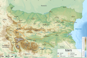
Bulgaria is a country situated in Southeast Europe that occupies the eastern quarter of the Balkan peninsula, being the largest country within its geographic boundaries. It borders Romania to the north, Serbia and North Macedonia to the west, Greece and Turkey to the south, and the Black Sea to the east. The northern border with Romania follows the river Danube until the city of Silistra. The land area of Bulgaria is 110,994 square kilometres (42,855 sq mi), slightly larger than that of Cuba, Iceland or the U.S. state of Tennessee. Considering its relatively compact territorial size and shape, Bulgaria has a great variety of topographical features. Even within small parts of the country, the land may be divided into plains, plateaus, hills, mountains, basins, gorges, and deep river valleys. The geographic center of Bulgaria is located in Uzana.

Tourism in Bulgaria is a significant contributor to the country's economy. Situated at the crossroads of the East and West, Bulgaria has been home to many civilizations: Thracians, Greeks, Romans, Eastern Romans or Byzantines, Slavs, Bulgars, and Ottomans. The country is rich in tourist sights and historical artifacts, scattered through a relatively small and easily accessible territory. Bulgaria is internationally known for its seaside and winter resorts.

<span class="mw-page-title-main">Balkan Mountains</span> Mountain range in the Balkan Peninsula

The Balkan mountain range is a mountain range in the eastern part of the Balkan Peninsula in Southeastern Europe. The range is conventionally taken to begin at the peak of Vrashka Chuka on the border between Bulgaria and Serbia. It then runs for about 560 kilometres (350 mi), first in a south-easterly direction along the border, then eastward across Bulgaria, forming a natural barrier between the northern and southern halves of the country, before finally reaching the Black Sea at Cape Emine. The mountains reach their highest point with Botev Peak at 2,376 metres (7,795 ft).

<span class="mw-page-title-main">Rila</span> Mountain range in Bulgaria

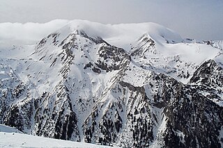
Rila is the highest mountain range of Bulgaria, the Balkan Peninsula and Southeast Europe. It is situated in southwestern Bulgaria and forms part of the Rila–Rhodope Massif. The highest summit is Musala at an elevation of 2,925 m which makes Rila the sixth highest mountain range in Europe after the Caucasus, the Alps, Sierra Nevada, the Pyrenees and Mount Etna, and the highest one between the Alps and the Caucasus. It spans a territory of 2,629 km2 with an average elevation of 1487 m. The mountain is believed to have been named after the river of the same name, which comes from the Old Bulgarian verb "рыти" meaning "to grub".

<span class="mw-page-title-main">Pirin</span> Mountain range in southwestern Bulgaria

The Pirin Mountains are a mountain range in southwestern Bulgaria, with the highest peak, Vihren, at an altitude of 2,914 m (9,560 ft).

<span class="mw-page-title-main">Pirin National Park</span> National park in Bulgaria

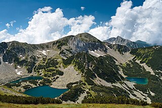
Pirin National Park, originally named Vihren National Park, encompasses the larger part of the Pirin Mountains in southwestern Bulgaria, spanning an area of 403.56 square kilometers (155.82 sq mi).

<span class="mw-page-title-main">Iskar (river)</span> River in Pleven, Bulgaria

The Iskar is a right tributary of the Danube. With a length of 368 km, it is the longest river that runs entirely within Bulgaria. Originating as three forks in Balkan's highest mountain range Rila, the Iskar flows in a northern direction until its confluence with the Danube. As it flows northwards it fuels the largest artificial lake in the country, the Iskar Reservoir, forms the divide between the Vitosha and Plana Mountains in the west and the Sredna Gora mountain range in the east before entering the Sofia Valley, which contains the nation's capital Sofia. From there the Iskar runs through the Balkan Mountains, forming the spectacular 84 km long Iskar Gorge. As it crosses the mountains, its water course turns in a north-eastern direction at Lakatnik. North of the Balkan Mountains, the river crosses the Danubian Plain and finally flows into the Danube between the villages of Baykal and Gigen. Geologically, Iskar is the oldest river in the Balkan Peninsula.

<span class="mw-page-title-main">Sredna Gora</span> Mountain range

Sredna Gora is a mountain range in central Bulgaria, situated south of and parallel to the Balkan Mountains and extending from the river Iskar to the west and the elbow of river Tundzha north of the city of Yambol to the east. Sredna Gora is 285 km long, reaching 50 km at its greatest width. Its highest peak is Golyam Bogdan at 1,604 m (5,262 ft). It is part of the Srednogorie mountain chain system, which extends longitudinally across the most country from west to east, between the Balkan Mountains and the Sub-Balkan valleys to the north and the Kraishte, Rila and the Upper Thracian Plain to the south.

<span class="mw-page-title-main">Vacha (river)</span> River in Bulgaria

The Vacha is a river in southern Bulgaria, a right tributary of the river Maritsa. The 112 km long Vacha is the 23rd longest river of Bulgaria and the second longest in the Rhodope Mountains, following the Arda (272 km), another major Maritsa tributary. The Vacha drains significant area of the western Rhodope Mountains, including the ridges Batak Mountain, Veliyshko–Videnishki, Pereliksko–Prespanski and Chernatitsa.

<span class="mw-page-title-main">Energy in Bulgaria</span>

Energy in Bulgaria is among the most important sectors of the national economy and encompasses energy and electricity production, consumption and transportation in Bulgaria. The national energy policy is implemented by the National Assembly and the Government of Bulgaria, conducted by the Ministry of Energy and regulated by the Energy and Water Regulatory Commission. The completely state-owned company Bulgarian Energy Holding owns subsidiaries operating in different energy sectors, including electricity: Kozloduy Nuclear Power Plant, Maritsa Iztok 2 Thermal Power Plant, NEK EAD and Elektroenergien sistemen operator (ESO); natural gas: Bulgargaz and Bulgartransgaz; coal mining: Maritsa Iztok Mines. In Bulgaria, energy prices for households are state-controlled, while commercial electricity prices are determined by the market.

100 Tourist Sites of Bulgaria is a Bulgarian national movement established in 1966 to promote tourism among Bulgaria's most significant cultural, historic, and natural landmarks.

<span class="mw-page-title-main">Strandzha Nature Park</span> Nature park in Bulgaria

Strandzha Nature Park is the largest protected area in Bulgaria spanning a territory of 1,161 square kilometres (448 sq mi) in the Strandzha Mountain in the extreme south-eastern corner of the country on the border with Turkey. It was established on 25 January 1995 to protect ecosystems and biodiversity of European importance, as well as the traditional cultural, historical and folklore heritage of the region. The altitude varies from 710 metres (780 yd) on Gradishte Peak to 0 metres (0 yd) at the Black Sea coast with average length of 50 kilometres (31 mi) from west to east and 20 kilometres (12 mi) from north to south.

<span class="mw-page-title-main">Yagodinska Cave</span>

Yagodinska Cave is a cave in the Rhodope Mountains, southern Bulgaria. It is included in the 100 Tourist Sites of Bulgaria and is named after the homonymous village nearby. With a total length of 10,500 m, Yagodinska is the fourth longest cave in the country after Kolkina Dupka, Duhlata and Orlova Chuka and the longest in the Rhodopes. Yagodinska Cave is home to 11 species of bats.

<span class="mw-page-title-main">Melnik Earth Pyramids</span> Geological formation in southwestern Bulgaria

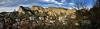
The Melnik Earth Pyramids are rock formations, known as hoodoos, situated at the foothills of the Pirin mountain range in south-western Bulgaria. They span an area of 17 km2 near the town of Melnik, Blagoevgrad Province. Reaching a height of up to 100 m these sandstone pyramids are shaped in forms, resembling giant mushrooms, ancient towers and obelisks. They were formed primarily due to erosion from rainfall and bedrock wear. The Melnik Earth Pyramids are a geological phenomenon of global importance and were declared a natural landmark in 1960. The rock formations are home to rich flora and fauna heavily influenced by the Mediterranean climate. They are a tourist destination due to the natural environment of the area, the cultural sights of Melnik and the Rozhen Monastery.

<span class="mw-page-title-main">Stob Earth Pyramids</span>

The Stob Earth Pyramids are rock formations, known as hoodoos, situated at the foothills of the Rila mountain range in south-western Bulgaria. They span an area of 0.7 km2 near the village of Stob, Kyustendil Province. The rock formations are up to 12 m high and up to 40 m thick at the base. Their shape is mostly conical to mushroomlike. Some of the columns are topped by flat stones.

<span class="mw-page-title-main">Zlatitsa–Pirdop Valley</span> Valley in Bulgaria

Zlatitsa–Pirdop Valley is situated in central western Bulgaria and is the fifth of the eleven Sub-Balkan valleys in direction west–east. It is named after the two towns that lie within, Zlatitsa and Pirdop. The valley is an important hub of the Bulgarian copper and gold mining and processing industry. It contains numerous natural and architectural landmarks, including the ruins of the late Roman Elenska Basilica.

<span class="mw-page-title-main">Samokov Valley</span> Valley in Bulgaria

Samokov Valley is situated in western Bulgaria, less that 25 km south of the outskirts of the capital Sofia. It is named after the town of Samokov, its main settlement. The valley is a hub for tourism in the neighbouring Rila mountain range to the south, the highest in Bulgaria and the Balkans.

References