Hindhead is a village in the Waverley district of the ceremonial county of Surrey, England. It is the highest village in the county and its buildings are between 185 metres (607 ft) and 253 metres (830 ft) above sea level. The village forms part of the Haslemere parish. Situated on the county border with Hampshire, it is best known as the location of the Devil's Punch Bowl, a beauty spot and site of special scientific interest.

Milford is a village in the civil parish of Witley south west of Godalming in Surrey, England that was a small village in the early medieval period — it grew significantly after the building of the Portsmouth Direct Line which serves Godalming railway station and its own minor stop railway station. The village, served by a wide array of shops and amenities, has to one side an all-directions junction of the A3, one of Britain's trunk roads. Nearby settlements are Eashing, Shackleford, Witley and Elstead, and the hamlets of Enton and Hydestile, all of which are in the Borough of Waverley. The west of the parish is in the Surrey Hills AONB.

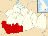
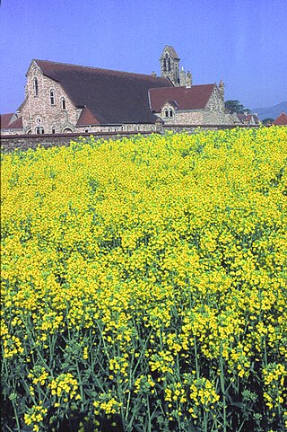
The Borough of Waverley is a local government district with borough status in Surrey, England. The council is based in the town of Godalming. The borough also contains the towns of Farnham and Haslemere and numerous villages, including the large village of Cranleigh, and surrounding rural areas. At the 2021 Census, the population of the borough was 128,200. The borough is named after Waverley Abbey, near Farnham. Large parts of the borough are within the Surrey Hills Area of Outstanding Natural Beauty.

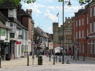
The town of Haslemere and the villages of Shottermill and Grayswood are in south west Surrey, England, around 38 mi (62 km) south west of London. Together with the settlements of Hindhead and Beacon Hill, they comprise the civil parish of Haslemere in the Borough of Waverley. The tripoint between the counties of Surrey, Hampshire and West Sussex is at the west end of Shottermill.
Horsham is a local government district in West Sussex, England. It is named after the town of Horsham, which is its largest settlement and where the council is based. The district also includes the surrounding rural area and contains many villages, the largest of which are Southwater and Billingshurst. The district includes part of the South Downs National Park and part of the designated Area of Outstanding Natural Beauty of High Weald. At the 2021 census the district had a population of 147,487.

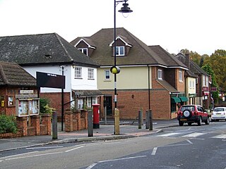
Witley is a village and civil parish in the Borough of Waverley in Surrey, England centred 2.6 miles (4 km) south west of the town of Godalming and 6.6 miles (11 km) southwest of Guildford. The land is a mixture of rural contrasting with elements more closely resembling a suburban satellite village.

Elstead is a civil parish in Surrey, England with shops, houses and cottages spanning the north and south sides of the River Wey; development is concentrated on two roads that meet at a central green. It includes Pot Common its southern neighbourhood. Hamlets in the parish, marginally separated from the village centre, are Charleshill and Elstead Common, both rich in woodland. Elstead lies between Farnham and Godalming on the B3001 road about 2.2 miles (3.6 km) west of the A3 Milford interchange.

Saint John, officially the Parish of Saint John, is a civil parish of Antigua and Barbuda, on the northwestern portion of Antigua island. Its capital is the city of St. John's. Saint John borders Saint Mary, Saint Peter, Saint George, and Saint Paul. Saint John faces the Caribbean Sea. Saint John is surrounded by some of Antigua's most premier beaches. Saint John had a population of 56,736 in a 2018 estimate, making it home to the majority of the population in Antigua and Barbuda.

Wonersh is a village and civil parish in the Waverley district of Surrey, England and Surrey Hills Area of Outstanding Natural Beauty. Wonersh contains three Conservation Areas and spans an area three to six miles SSE of Guildford.

Monks Eleigh is a village and a civil parish in Babergh, Suffolk, United Kingdom, situated on the tributary to the River Brett in a rural area. The parish contains the hamlets of Swingleton Green and Stackyard Green.
Rosewell is a former mining village in Midlothian, Scotland, east of Roslin and south-west of Bonnyrigg. The village is in the civil parish of Lasswade and was previously a separate ecclesiastical parish, but has its own Community Council, namely Rosewell and District.
Frensham is a village in Surrey, England, next to the A287 road, 13 miles (20.9 km) WSW of Guildford, the county town. Frensham lies on the right bank of the River Wey, only navigable to canoes, shortly before its convergence with the north branch. Farnham is the nearest town, 3.5 miles (5.6 km) to the north.

Weston under Wetherley, often known by locals as just Weston, is a small village and civil parish in Warwickshire, England. It is on the B4453, 4 miles (6.4 km) northeast of the closest town, Royal Leamington Spa. According to the 2001 Census the village had a population of 454 living in 164 houses. The population taken at the 2011 Census was 468. The most notable buildings is the parish church of Saint Michael. Weston is unusual amongst settlements in the United Kingdom of its size in that there is not a single shop there, the last being demolished in the 1990s, nor a pub, which was closed in 2014.
Churt is a village and civil parish in the borough of Waverley in Surrey, England, about 5.5 miles (8.9 km) south of the town of Farnham on the A287 road towards Hindhead. A clustered settlement is set in areas acting as its green buffers, which include the Devil's Jumps. The west of the village slopes down to the steep edge of Whitmore Vale, which is mostly in Headley, Hampshire; at the foot of this bank is a steeply cut brook which defines the Hampshire border. There are forests and heathland by and atop the Greensand Ridge, and the hamlet of Crosswater is in the north of the parish.

Busbridge is a village and civil parish in the borough of Waverley in Surrey, England that adjoins the town of Godalming. It forms part of the Waverley ward of Bramley, Busbridge and Hascombe. It was until the Tudor period often recorded as Bushbridge and was a manor and hamlet of Godalming until gaining an ecclesiastical parish in 1865 complemented by a secular, civil parish in 1933. Gertrude Jekyll lived at Munstead Wood in the Munstead Heath locality of the village. Philip Carteret Webb and Chauncy Hare Townshend, the government lawyer/antiquarian and poet respectively owned its main estate, Busbridge House, the Busbridge Lakes element of which is a private landscape garden and woodland that hosts a wide range of waterfowl.

Dockenfield is a village and civil parish in the borough of Waverley in Surrey, England. The parish is undulating, has a number of sources of the River Wey and borders the Alice Holt Forest. Dockenfield was historically part of Hampshire, being transferred to Surrey in 1895.

Ramsnest Common is a hamlet in the far south of the Borough of Waverley, the largest district of Surrey, England centred on the A283 1.5 miles (2.4 km) SSW of Chiddingfold village centre between Milford and Petworth in West Sussex which it borders. The area of overwhelmingly rural land, most of which is scattered forest, in particular Killinghurst Great Copse, had no medieval settlement.

Hydestile is a hamlet in Waverley, south-west Surrey. It is around 2+1⁄2 miles (4.0 km) south of Godalming between the villages of Busbridge and Hambledon, straddling their civil parish borders. One landmark of the hamlet is Hydon's Ball, a large woodland and promontory of the Greensand Ridge, about which a very old poem has been written; the site is within National Trust land and free to visitors.

Neatham is a Roman hamlet, an ancient hundred and a former civil parish, now in the parish of Alton, in the East Hampshire district of Hampshire, England. Its nearest town is Alton, which lies 1.6 miles (2.6 km) south-west from the hamlet. In 1931 the parish had a population of 134.