List of settlements in West Sussex by population

Last updated

This is a list of settlements in West Sussex by population based on the results of the 2011 census. The next United Kingdom census took place in 2021. In 2011, there were 20 built-up area subdivisions with 5,000 or more inhabitants in West Sussex, shown in the table below.

Contents

Population ranking

No.SettlementBorough/DistrictPopulationNotes
(2001) [1] (2011) [2]
1 Worthing Worthing101,929109,120Includes Ferring
2 Crawley Crawley99,660106,943
3 Bognor Regis Arun 61,80063,885Includes Flansham, Middleton-on-Sea, Pagham. Excludes Bilsham, Colworth, Shripney
4 Littlehampton Arun50,93055,706Includes Angmering, Hammerpot, West Kingston, Wick. Excludes Lyminster, Poling
5 Shoreham-by-Sea Adur 47,02048,487Includes Sompting
6 Horsham Horsham 44,89048,041Includes Roffey
7 Haywards Heath Mid Sussex 29,11033,845Includes Bolnore Village, Lindfield. Excludes Cuckfield, Scaynes Hill, Walstead
8 Burgess Hill Mid Sussex29,38830,635Includes World's End. Excludes Goddards Green, Wivelsfield
9 East Grinstead Mid Sussex26,49029,084Includes Ashurst Wood, Ashplats, Felbridge, Imberley. Excludes Crawley Down, Domewood, Dormans Park, Effington Park, Forest Row
10 Chichester Chichester 25,52028,657Includes Stockbridge, Summerdale. Excludes Apuldram, Donnington, Fishbourne, Hunston, Lavant, Merston, North Mundham, Runction, Westhampnett
11 Hurstpierpoint Mid Sussex11,17312,730Includes Hassocks
12 Southwick Adur11,51311,551
13 Selsey Chichester9,72010,550Excludes Church Norton
14 Westergate Arun9,0999,783Includes Barnham, Eastergate, Fontwell, Walberton. Excludes Aldingbourne, Norton, Slindon, Yapton
15 Southwater Horsham8,2988,692
16 Storrington Horsham7,7308,618Includes Heath Common. Excludes Ashington, Rock, Sullington, Washington, West Wantley
17 West Chiltington Common Horsham6,9407,474Includes Pulborough
18 Billingshurst Horsham5,4606,911
19 Steyning Horsham6,3656,557Excludes Annington, Bramber
20 East Wittering Chichester5,1275,647Includes Bracklesham. Excludes Earnley
Midhurst Chichester4,8894,914Excludes Easebourne, West Lavington
Henfield Horsham4,5274,799Excludes West End, Woodmancote
Crawley Down Mid Sussex4,6314,598Excludes Turners Hill

See also

Related Research Articles

<span class="mw-page-title-main">Sussex</span> Historic county of England

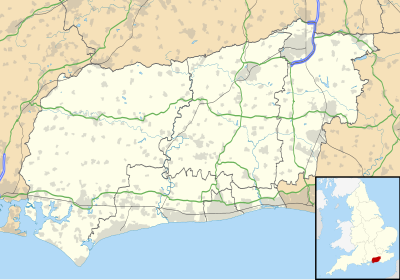
Sussex, from the Old English Sūþsēaxe, is a historic county in South East England that was formerly an independent medieval Anglo-Saxon kingdom. It is bounded to the west by Hampshire, north by Surrey, northeast by Kent, south by the English Channel, and divided for many purposes into the ceremonial counties of West Sussex and East Sussex.

<span class="mw-page-title-main">Horsham District</span> Non-metropolitan district in England

Horsham is a local government district in West Sussex, England. Its council is based in Horsham. The district borders those of Crawley, Mid Sussex, Mole Valley, Chichester, Arun and Adur, and the unitary authority of Brighton & Hove.

Bersted is a civil parish in the Arun district of West Sussex, England. It is made up of two somewhat independent villages, North Bersted and Shripney which contribute to some common amenities.

The Leicester Urban Area or Leicester Built Up Area is an urban agglomeration defined by the Office of National Statistics (ONS), centred on the City of Leicester in the English Midlands. With a population of 508,916 at the time of the 2011 census, the Built Up Area is the eleventh largest in England and thirteenth largest in the United Kingdom. It comprises Leicester itself and its suburbs, all of which are contiguous with, or situated in close proximity to, the city.

<span class="mw-page-title-main">Brighton and Hove built-up area</span> Conurbation in England

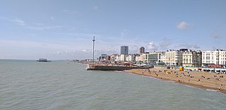
The Brighton and Hove Built-up area or Brighton/Worthing/Littlehampton conurbation has a population of 474,485, making it England's 12th largest conurbation. This was an increase of around 3% from the 2001 population of 461,181. Named the Brighton/Worthing/Littlehampton conurbation by the Office for National Statistics for the 2001 census and Brighton and Hove Built-up area for the 2011 census, the area has also been known as Greater Brighton, although the Greater Brighton City Region that was created in 2014 from 7 local authorities in Sussex covers a much larger area. The conurbation dominates West and East Sussex, with around 1 in 3 of Sussex's population living within its boundaries. It is also the second largest conurbation in the South East region of England and the second largest conurbation on the English Channel coast, in either England or France. In both of these cases the Brighton conurbation trails the Southampton and Portsmouth conurbation. The Brighton/Worthing/Littlehampton conurbation was the largest on the Channel before Portsmouth and Southampton's conurbations were combined for much official data analysis after the 2011 census.

References

  1. "West Sussex (County, South East England, United Kingdom) - Population Statistics and Location in Maps and Charts". www.citypopulation.de. Retrieved 25 November 2016.
  2. "KS101EW (Usual resident population) - Nomis - Official Labour Market Statistics". www.nomisweb.co.uk. Retrieved 24 November 2016.