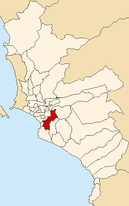
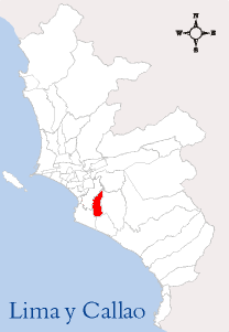
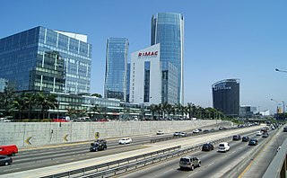
Lima, founded in 1535 as the Ciudad de los Reyes, is the capital and largest city of Peru. It is located in the valleys of the Chillón, Rímac and Lurín Rivers, in the desert zone of the central coastal part of the country, overlooking the Pacific Ocean. The city is considered the political, cultural, financial and commercial center of Peru. Due to its geostrategic importance, the Globalization and World Cities Research Network has categorized it as a "beta" tier city. Jurisdictionally, the metropolis extends mainly within the province of Lima and in a smaller portion, to the west, within the Constitutional Province of Callao, where the seaport and the Jorge Chávez Airport are located. Both provinces have regional autonomy since 2002.
Santiago de Surco, commonly known simply as Surco, is a district of Lima, Peru. It is bordered on the north with the district of Ate Vitarte and La Molina; on the east with San Juan de Miraflores, on the west with San Borja, Surquillo, Miraflores and Barranco, and on the south with Chorrillos.

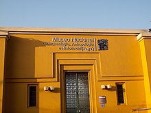
Barranco, founded in 1874 as San José de Surco, is one of 43 districts in Lima, Peru. Its current mayor is Jessica Vargas.
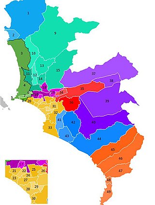
The Lima Metropolitan Area is an area formed by the conurbation of the Peruvian provinces of Lima and Callao. It is the largest of the metropolitan areas of Peru, the seventh largest in the Americas, the fourth largest in Latin America, and among the thirty largest in the world. The conurbation process started to be evident in the 1980s.

Rímac, known until the 19th century as the neighbourhood of San Lázaro, is a district in the Lima Province, Peru. It lies directly to the north of downtown Lima, to which it is connected by six bridges over the Rímac River. The district also borders the Independencia, San Martín de Porres, and San Juan de Lurigancho districts. Vestiges of Lima's colonial heyday remain today in an area of the Rímac district known as the Historic centre of Lima, which was declared a UNESCO World Heritage Site in 1988. Downtown Rímac District has, like its southern counterpart, its eastern and western sides divided by Jirón Trujillo, which connects to Lima District's Jirón de la Unión through the Puente de Piedra, the oldest bridge in the whole city. Rímac's East side features the Plaza de Acho, the most famous bullfighting arena in South America and one of the most well known in the world.

The district of La Molina is one of the forty-three districts that make up the province of Lima, located in the department of the same name, in Peru. Officially established as a district on February 6, 1962. The current mayor of La Molina is Esteban Diego Uceda Guerra-García.

Surquillo District is a district in Lima, Peru. The district is bordered by the districts of San Isidro and San Borja on the north; by Miraflores on the south and west; and by Santiago de Surco on the east.

The Historic Centre of Lima is the historic city centre of the city of Lima, the capital of Peru. Located in the city's districts of Lima and Rímac, both in the Rímac Valley, it consists of two areas: the first is the Monumental Zone established by the Peruvian government in 1972, and the second one—contained within the first one—is the World Heritage Site established by UNESCO in 1988, whose buildings are marked with the organisation's black-and-white shield.

San Borja is a district of the Lima Province in Peru, and one of the upscale districts that comprise the city of Lima. Originally part of the district of Surquillo and San Isidro, it became officially established as a separate district on June 1, 1983. The new district took its name from a former hacienda (estate) which dominated the area. The district's postal code is 41. The current mayor (alcalde) is Marco Antonio Álvarez Vargas.

Bembos is a Peruvian fast food chain offering hamburgers, often with Peruvian-influenced variations.

Miraflores is a district of the Lima Province in Peru. It is a residential and upscale shopping district south of downtown Lima. It is also one of the wealthiest districts that make up the city of Lima. It has several hotels, restaurants, bars, nightclubs, and department stores. Miraflores is one of the main tourist destinations in Lima.
The Ate district, also called Ate-Vitarte, is one of the forty-three districts that make up the Lima Province, located in Peru.
The district of San Juan de Miraflores is one of the forty-three districts that make up the province of Lima, located in the department of the same name, in Peru. Is one of the new towns, that have been formed by the massive numbers of people moving from other towns of Metropolitan Lima and from the countryside. During the early 1960s, was mostly a desert area.
A Peruvian postal code is a five-digit string that comprises part of a postal address in Peru. Prior to 2011, only the major cities of Lima and Callao used postal codes. However, in February 2011 a nationwide system was implemented which employs a five-digit numeric format. Similar to the postal codes of Mexico, Brazil, Australia, the United States, and elsewhere, postal codes in Peru are strictly numerical, using only numbers.
The Battle of Miraflores occurred on January 15, 1881 in the Miraflores District of Lima, Peru. It was an important battle during the War of the Pacific that was fought between Chile and the forces of Peru. The Chilean army led by Gen. Manuel Baquedano defeated the army commanded by Nicolás de Piérola guarding the second defensive line of the Peruvian capital city. Two days later, Lima, the capital city of Peru was occupied by Chilean troops. Gen. Baquedano's forces marched into Lima triumphant, while Peru's president and his officers fled into the interior, leaving the country without any government. Even after the fall of Lima, the war continued between the occupation army and the troops of Andres Caceres for another three years. During the occupation of Lima, Peru's National Library was burned, while a number of other monuments were ransacked by Chilean forces and taken as war trophies.

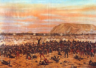
The Battle of San Juan, also known as the Battle of San Juan and Chorrillos, was the first of two battles in the Lima Campaign during the War of the Pacific, and was fought on 13 January 1881. This battle is really a group of smaller, yet fierce confrontations at the defensive strongholds of Villa, Chorrillos, Santiago de Surco, San Juan de Miraflores, Santa Teresa and Morro Solar. The Chilean army led by Gen. Manuel Baquedano inflicted a harsh defeat on the Peruvian army commanded by the Supreme Chief Nicolás de Piérola. The Chilean triumph eliminated the first defensive line guarding Lima, and almost obliterated the Peruvian army defending it.
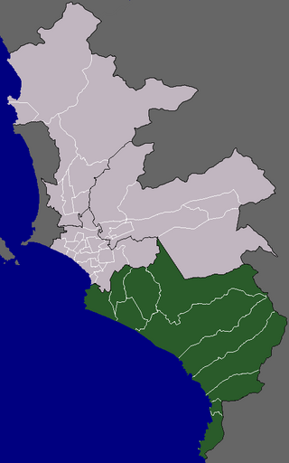
The Cono Sur or Lima Sur is one of the five areas that make up the Lima Metropolitan Area. It is located in the southern part of the metropolis hence its name. This socioeconomic levels of this district are varied. Most of the population however belongs to the lower and middle classes. But it is the area closest to the districts of the modern zone and residential areas like Miraflores, La Molina, Santiago de Surco, etc. Many of the residents belonging to these districts are immigrants from various regions of the country. As they settled there, some developed successful communities such as Villa El Salvador, while others still live in poor housing known as Pueblos jóvenes. The area is popular for its beaches, farms and factories in that population greatly increases during the summer months.
Luis Fernán Bedoya Reyes Expressway, also known by its former name, Paseo de la República, or by its nickname, El Zanjón, is the most representative avenue of Lima, Peru. It crosses the districts of Lima, Lince, La Victoria, San Isidro, Surquillo, Miraflores, Barranco and Chorrillos from north to south along 66 blocks. COSAC I of the Metropolitano extends along its entire length, being one of the widest avenues in the city and country.

The Parque Reducto No. 2 is a 20,000 m2 public park located at the intersections of Benavides and Luis Bedoya Reyes avenues, in Miraflores District, Lima, Peru. Located in a former redoubt built by the Peruvian Army during the War of the Pacific, it was declared a National Monument in 1944, and a Patriotic Sanctuary in 1965.