Related Research Articles

Lake Pontchartrain is a brackish estuary located in southeastern Louisiana in the United States. It covers an area of 630 square miles (1,600 km2) with an average depth of 12 to 14 feet. Some shipping channels are kept deeper through dredging. It is roughly oval in shape, about 40 miles (64 km) from west to east and 24 miles (39 km) from south to north.
A causeway is a track, road or railway on the upper point of an embankment across "a low, or wet place, or piece of water". It can be constructed of earth, masonry, wood, or concrete. One of the earliest known wooden causeways is the Sweet Track in the Somerset Levels, England, which dates from the Neolithic age. Timber causeways may also be described as both boardwalks and bridges.

The Lake Pontchartrain Causeway, also known as The Causeway, is a fixed link composed of two parallel bridges crossing Lake Pontchartrain in southeastern Louisiana, United States. The longer of the two bridges is 23.83 miles (38.35 km) long. The southern terminus of the causeway is in Metairie, Louisiana, a south shore suburb of New Orleans. The northern terminus is in Mandeville, Louisiana, a north shore suburb of New Orleans.

A trestle bridge is a bridge composed of a number of short spans supported by closely spaced frames. A trestle is a rigid frame used as a support, historically a tripod used to support a stool or a pair of isosceles triangles joined at their apices by a plank or beam such as the support structure for a trestle table. Each supporting frame is a bent. A trestle differs from a viaduct in that viaducts have towers that support much longer spans and typically have a higher elevation.

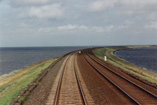
The Lucin Cutoff is a 102-mile (164 km) railroad line in the western United States in Utah which runs from Ogden to its namesake in Lucin. The most prominent feature of the cutoff was a twelve-mile-long (19 km) railroad trestle crossing the Great Salt Lake; in use from 1904 until the late 1950s, when it was replaced by a earthen causeway.

The National Register of Historic Places in the United States is a register including buildings, sites, structures, districts, and objects. The Register automatically includes all National Historic Landmarks as well as all historic areas administered by the U.S. National Park Service. Since its introduction in 1966, more than 90,000 separate listings have been added to the register.

The Bonnet Carré Spillway is a flood control operation in the Lower Mississippi Valley. Located in St. Charles Parish, Louisiana, about 12 miles (19 km) west of New Orleans, it allows floodwaters from the Mississippi River to flow into Lake Pontchartrain and thence into the Gulf of Mexico. The spillway was constructed between 1929 and 1931, following the Great Mississippi Flood of 1927, and has been designated as a National Historic Civil Engineering Landmark by the American Society of Civil Engineers.

Temescal Creek is one of the principal watercourses in the city of Oakland, California, United States.
America's 11 Most Endangered Places or America's 11 Most Endangered Historic Places is a list of places in the United States that the National Trust for Historic Preservation considers the most endangered. It aims to inspire Americans to preserve examples of architectural and cultural heritage that could be "relegated to the dustbins of history" without intervention.
The names Southern Pacific Depot, Southern Pacific Railroad Station, Southern Pacific Railroad Depot, and variations, apply to a number of train stations operated by the Southern Pacific Railroad. Many of these are historic and are listed on the U.S. National Register of Historic Places (NRHP).

The Overland Route was a train route operated jointly by the Union Pacific Railroad and the Central Pacific Railroad / Southern Pacific Railroad, between Council Bluffs, Iowa / Omaha, Nebraska, and San Francisco, California, over the grade of the first transcontinental railroad which had been opened on May 10, 1869. Passenger trains that operated over the line included the Overland Flyer, later renamed the Overland Limited, which also included a connection to Chicago. Although these passenger rail trains are no longer in operation, the Overland Route remains a common name for the line from Northern California to Chicago, now owned entirely by the Union Pacific.
The Alamogordo and Sacramento Mountain Railway was built as a branch line for the El Paso and Northeastern Railway (EP&NE). Construction began from the EP&NE connection at Alamogordo, New Mexico, in 1898 to reach the Sacramento Mountain fir and spruce forests to the east. Sawmills were built in Alamogordo to mill lumber for extension of the EP&NE to reach the Chicago, Rock Island and Pacific Railroad. The railroad reached Cloudcroft, New Mexico, in 1900, where a lodge was built for summer tourists to enjoy the cool mountain air. Cloudcroft was laid out in several villages so tourists might avoid associating too closely with loggers and railway workers. The railway was extended from Cloudcroft to the small community of Russia, New Mexico, in 1903; and several branches were built to reach timber for the Alamogordo Lumber Company.
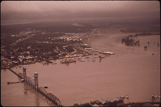
The Mississippi flood of 1973 occurred between March and May 1973 on the lower Mississippi River. The flooding was the third most severe along the U.S.'s Mississippi River during the 20th century.

The Charlotte Harbor and Northern Railway is a historic railroad line that at its greatest extent serviced Gasparilla Island in Charlotte Harbor and a major shipping port that once operated there. The railroad's principal purpose was to transport phosphate mined along the Peace River and in the Bone Valley region of Central Florida to the port to be shipped. It also brought passengers to the island community of Boca Grande on Gasparilla Island, and is largely responsible for making Boca Grande the popular tourist destination it is today. Part of the line remains in service today between Mulberry and Arcadia, which is now owned and operated by CSX Transportation. Today, it makes up CSX's Achan Subdivision and part of their Brewster Subdivision.
The I-10 Bonnet Carré Spillway Bridge is a twin concrete trestle bridge in the U.S. state of Louisiana. With a total length of 58,077 feet, it is one of the longest bridges in the world. The bridge carries Interstate 10 over the Bonnet Carré Spillway, Lake Pontchartrain, and LaBranche Wetlands in St. Charles Parish and a portion of St. John the Baptist and Jefferson Parishes. The bridge opened in 1972.
The CNR Bonnet Carré Spillway-McComb Bridge is a 2.3-mile-long (3.7 km) bridge that carries Canadian National Railway tracks over the Bonnet Carré Spillway and a portion of Lake Pontchartrain in St. Charles Parish and St. John the Baptist Parish. Its length makes it one of the longest bridges in the world.
The U.S. 61 Bonnet Carré Spillway Bridge is a twin concrete trestle bridge in the U.S. state of Louisiana. It has a total length of 1,830.62 metres (6,006.0 ft). The bridge carries U.S. Route 61 (Airline Highway) over the Bonnet Carré Spillway in St. Charles Parish. The original bridge opened in 1935 serving four narrow lanes of traffic; however, due to frequent traffic congestion and accidents, a parallel span opened in 1984. The original span currently serves eastbound traffic, while the newer span serves westbound traffic.
Bridge A 249 is a historic wooden trestle bridge in New Mexico's Sacramento Mountains, Otero County, New Mexico, just outside Cloudcroft, New Mexico. It was listed on the National Register of Historic Places in 2015 as Bridge A 249-Cloudcroft, New Mexico.
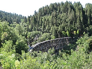
Mexican Canyon Trestle is a historic wooden trestle bridge in New Mexico's Sacramento Mountains, Otero County, New Mexico, just outside Cloudcroft, New Mexico. It was listed on the National Register of Historic Places in 1979.
References
- 1 2 3 4 5 6 7 8 9 10 "National Register Information System". National Register of Historic Places . National Park Service. November 2, 2013.