
Suriname, officially the Republic of Suriname, is a country in northern South America, sometimes considered part of the Caribbean and the West Indies. Situated slightly north of the equator, over 90% of its territory is covered by rainforests, the highest proportion of forest cover in the world. Suriname is bordered by the Atlantic Ocean to the north, French Guiana to the east, Guyana to the west, and Brazil to the south. It is the smallest country in South America by both population and territory, with around 612,985 inhabitants in an area of approximately 163,820 square kilometers. The capital and largest city is Paramaribo, which is home to roughly half the population.

As part of the foreign relations of Suriname, the country is a participant in numerous international organizations.

The Guiana Shield is one of the three cratons of the South American Plate. It is a 1.7 billion-year-old Precambrian geological formation in northeast South America that forms a portion of the northern coast. The higher elevations on the shield are called the Guiana Highlands, which is where the table-like mountains called tepuis are found. The Guiana Highlands are also the source of some of the world's most well-known waterfalls such as Angel Falls, Kaieteur Falls and Cuquenan Falls.

The Dutch began their colonisation of the Guianas, the coastal region between the Orinoco and Amazon rivers in South America, in the late 16th century. The Dutch originally claimed all of Guiana but—following attempts to sell it first to Bavaria and then to Hanau and the loss of sections to Portugal, Britain, and France—the section actually settled and controlled by the Netherlands became known as Dutch Guiana.
Marowijne is a district of Suriname, located on the north-east coast. Marowijne's capital city is Albina, with other towns including Moengo and Wanhatti. The district borders the Atlantic Ocean to the north, French Guiana to the east, the Surinamese district of Sipaliwini to the south, and the Surinamese districts of Commewijne and Para to the west.

Sipaliwini is the largest district of Suriname, located in the south. Sipaliwini is the only district that does not have a regional capital, as it is directly administered by the national government in Paramaribo. Sipaliwini District includes disputed areas, with the southwestern region controlled and administered by Guyana, whereas the southeastern region is controlled by French Guiana.

The Guianas, also spelled Guyanas or Guayanas, is a region in north-eastern South America. Strictly, the term refers to the three Guyanas: Guyana, Suriname and French Guiana, formerly British, Dutch and French Guyana. Broadly it refers to the South American coast from the mouth of the Oronoco to the mouth of the Amazon.

The Maroni or Marowijne is a river in South America that forms the border between French Guiana and Suriname.

The Aluku are a Bushinengue ethnic group living mainly on the riverbank in Maripasoula in southwest French Guiana. The group are sometimes called Boni, referring to the 18th-century leader, Bokilifu Boni.

The Paramaccan or Paramaka are a Maroon tribe living in the forested interior of Suriname, mainly in the Paramacca resort, and the western border area of French Guiana. The Paramaccan signed a peace treaty in 1872 granting the tribe autonomy.
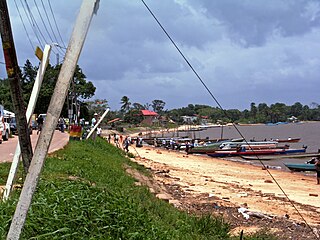
Albina is a town in eastern Suriname, and is capital of the Marowijne District. The town lies on the west bank of the Marowijne river, which forms the border with French Guiana, directly opposite the French Guianan town of Saint-Laurent-du-Maroni, to which it is connected by a frequent ferry service. Albina can be reached by bus via the East-West Link. The distance between Paramaribo and Albina is about 150 kilometres (95 mi).

The Surinamese Football Association is the governing body of football in Suriname. It organizes the Surinamese football league system, the Surinamese Cup, Suriname President's Cup, Suriname national football team, and the Suriname women's national football team. It is based in Paramaribo, and is a founding member of CONCACAF and a member of FIFA.

The Ndyuka people or Aukan people (Okanisi), are one of six Maroon peoples in the Republic of Suriname and one of the Maroon peoples in French Guiana. The Aukan or Ndyuka speak the Ndyuka language. They are subdivided into the Opu, who live upstream of the Tapanahony River in the Tapanahony resort of southeastern Suriname, and the Bilo, who live downstream of that river in Marowijne District.

The borders of Suriname consist of land borders with three countries: Guyana, Brazil, and France. The borders with Guyana and France are in dispute, but the border with Brazil has been uncontroversial since 1906.

Suriname was a constituent country of the Kingdom of the Netherlands between 1954 and 1975. The country had full autonomy, except in areas of defence and foreign policy, and participated on a basis of equality with the Netherlands Antilles and the Netherlands itself in the Kingdom of the Netherlands. The country became fully independent as the Republic of Suriname on 25 November 1975.
Surinam, also unofficially known as Dutch Guiana, was a Dutch plantation colony in the Guianas, bordered by the equally Dutch colony of Berbice to the west, and the French colony of Cayenne to the east. It later bordered British Guiana from 1831 to 1966.

The Tigri Area is a wooded area that has been disputed by Guyana and Suriname since around 1840. It involves the area between the Upper Corentyne River, the Coeroeni River, and the Kutari River. This triangular area is known as the New River Triangle in Guyana. In 1969 the conflict ran high on, and since then it has been controlled by Guyana and claimed by Suriname. In 1971, both governments agreed that they would continue talks over the border issue and withdraw their military forces from the disputed triangle. Guyana has never held upon this agreement.

Stoelmanseiland is an island, and a village in the Paramacca resort of the Sipaliwini District in Suriname. It is located at the confluence of the Tapanahony River with the Lawa River which forms the Marowijne River, and is also the border with French Guiana.

Diplomatic relations between France and Suriname were established on 25 August 1976. Suriname and the French overseas department of French Guiana share a common border of 520 kilometres (320 mi). Suriname operates an embassy in Paris, a consulate in Cayenne, and an honorary consulate in Saint-Laurent-du-Maroni. France operates an embassy in Paramaribo, a consulate in Georgetown, Guyana, and an honorary consulate in Albina.

The history of Suriname during World War II was mainly focused on protecting the bauxite industry and guarding the borders with French Guiana which was part of Vichy France. From November 1941 onwards, 2,000 American troops were stationed in Suriname who transformed Airstrip Zanderij into a major airport, and constructed defensive works. No actual battles took place in Suriname. There was a political crisis in 1943, because Governor Johannes Kielstra used the state of emergency to imprison political opponents.
