Windmills
| Name, Coordinates | Type | Year built | Remarks | Photograph |
|---|---|---|---|---|
| Babbersmolen 51°55′2.05″N4°22′25.56″E / 51.9172361°N 4.3737667°E | Stellingmolen | 1710 | This drainage mill was working until 1924, when it was dismantled and truncated. It was rebuilt and restored in 2012. [1] |  |
| Brandersmolen or Gekroonde Brandersketel 51°54′53″N4°23′46″E / 51.914635°N 4.396203°E | Stellingmolen | 1711 | This malt mill was demolished in 1871. [2] | |
| Clopmolen 51°55′06″N4°23′31″E / 51.918418°N 4.391817°E | Grondzeiler | This hemp-beating mill was marked on maps dated 1598 and 1632. [3] | ||
| De Batavier 51°54′54″N4°24′08″E / 51.915054°N 4.402212°E | Stellingmolen | 1797 | This malt mill worked until 1900 when the cap was removed. Shortly afterwas the tower was reduced to a stump, which was demolished between December 1906 and January 1907. [4] | |
| De Cleenpoldermolen, Kethel 51°23′38″N4°23′32″E / 51.393841°N 4.392098°E | Wipmolen | A drainage mill was marked on a map of 1611. This was a small mill. It was demolished in 1903. [5] | ||
| De Drie Koornbloemen 51°55′3.53″N4°23′33.64″E / 51.9176472°N 4.3926778°E | Stellingmolen | 1770 | This corn, pearl barley and saw mill worked until 1970. It was restored in 1976. [6] |  |
| De Eendragt 51°54′57″N4°24′09″E / 51.915862°N 4.402412°E | Stellingmolen | 1778 | A malt mill, it was demolished in 1907. [7] | |
| De Gapert 51°54′49″N4°23′55″E / 51.913504°N 4.398583°E | Standerdmolen | 1634 | This corn mill had gone by 1694. [8] | |
| De Gapert 51°54′49″N4°23′55″E / 51.913504°N 4.398583°E | Stellingmolen | 1711 | This corn and malt mill was burnt out on 24 January 1864. It was replaced by a steam mill with the same name. [9] |  |
| De Hoop or Jefferson's Molen 51°54′48″N4°24′02″E / 51.913306°N 4.400680°E | Stellingmolen | 1727 | This malt mill was partly demolished in 1900, leaving a five-storey stump which was demolished in 1907. [10] |  |
| De Kameel 51°55′11″N4°24′06″E / 51.919687°N 4.401572°E | Stellingmolen | 1715 | This malt mill was working until the cap and sails were blown off on 20 March 1865. The tower was demolished in January 1868. [11] | |
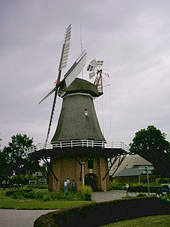
| De Kameel 51°55′10″N4°24′4.17″E / 51.91944°N 4.4011583°E | Stellingmolen | 2010 | This corn mill also generates electricity. It stands close to the site of the original De Kameel. [12] |  |
| De Kopermolen 51°54′31″N4°22′57″E / 51.908702°N 4.382496°E | Unknown | 1781 | This drainage mill was last mentioned in 1783. [13] | |
| De Meyboom, De Meijboom, De Meiboom 51°54′51″N4°24′08″E / 51.914263°N 4.402171°E | stellingmolen | 1779 | This corn mill was demolished in 1860, leaving a three storey stump, which was demolished in 1926. [14] | |
| De Morgenzon 51°54′26″N4°24′30″E / 51.907095°N 4.408228°E | Stellingmolen | 1780 | This mill was built as a cement mill. It was later a white lead mill and a snuff mill. It was demolished c. 1810. [15] | |
| De Nieuwe Palmboom 51°55′14.61″N4°23′55.37″E / 51.9207250°N 4.3987139°E | Stellingmolen | 1992 | This corn mill was built of the stump of the original De Palmboom. [16] | 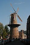 |
| De Nolet 51°54′27.18″N4°24′29.61″E / 51.9075500°N 4.4082250°E | Stellingmolen | 2005 | It looks like a Schiedam windmill, but it's in fact a disguised wind turbine. |  |
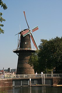
| De Noord 51°55′13.81″N4°23′49.01″E / 51.9205028°N 4.3969472°E | Stellingmolen | 1803 | This corn mill worked until 1937, when it was dismantled leaving the tower standing. It was restored in 1962. It is the tallest windmill in the world. [17] |  |
| De Palmboom 51°55′15″N4°23′55″E / 51.920759°N 4.398685°E | Stellingmolen | 1781 | This malt and rye mill was burnt out on 19 August 1901. It was subsequently demolished leaving a two storey stump. A third storey was added in 1955. De Nieuwe Palmboom was built on the stump in 1987-89. [18] |  |
| De Ploeg or Ploegmolen 51°54′29″N4°24′27″E / 51.908194°N 4.407376°E | Stellingmolen | 1782 | A pearl barley mill, also later a malt mill. Demolished in 1902. [19] | |
| De Steene Moole 51°54′51″N4°24′07″E / 51.914098°N 4.401869°E | Stellingmolen | 1683 | This corn mill was demolished in 1773. De Meyboom was built to replace it. [20] | |
| De Ster or Starremolen 51°55′08″N4°23′35″E / 51.918877°N 4.392926°E | Stellingmolen | 1716 | A distillery mill, it was burnt down in 1823. [21] | |
| De Vlijt 51°54′35″N4°24′33″E / 51.909826°N 4.409055°E | Paltrokmolen | 1788 | This saw mill was demolished in 1880. [22] | |
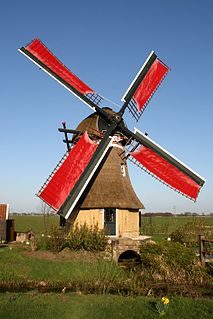
| De Vrijheid 51°55′11.09″N4°23′41.26″E / 51.9197472°N 4.3947944°E | Stellingmolen | 1785 | This corn mill worked until c.1950. It was restored in 1972. [23] |  |
| De Walvisch 51°54′56.4″N4°23′42.59″E / 51.915667°N 4.3951639°E | Stellingmolen | 1794 | This corn mill was damaged by fire on 9 December 1938, the bottom four floors were severely affected. It was restored in 1970 but was burnt out on 14 February 1996. The mill was restored in 1998. [24] |  |
| De Washington, De Wilhelmina 51°55′01″N4°24′09″E / 51.916907°N 4.402389°E | Stellingmolen | 1792 | This malt mill was renamed De Wilhelmina in 1898. It was demolished October-November 1903. [25] | |
| De Wipmolen or De Beukmolen 51°55′15″N4°23′55″E / 51.920759°N 4.398685°E | Wipstellingmolen | 1709 | A drainage mill that burnt down on 5 August 1733. [26] | |
| De Witte or Witte Molen 51°55′06″N4°24′08″E / 51.918397°N 4.402153°E | Stellingmolen | 1792 | A malt mill, it was demolished in 1892. [27] | |
| Hargmolen, Kethel 51°55′51″N4°23′01″E / 51.930753°N 4.383677°E | Grondzeiler | This drainage mill was standing in 1479. It burnt down in 1574. [28] | ||
| Hargmolen, Kethel 51°55′51″N4°23′01″E / 51.930753°N 4.383677°E | Grondzeiler | 1575 | This drainage mill was demolished in 1877. [29] | |
| Hargmolen, Kethel 51°55′51″N4°23′01″E / 51.930753°N 4.383677°E | Grondzeiler | 1877 | This drainage mill was moved here from Kortenoord, South Holland. It was demolished in 1925. It was replaced by a diesel powered pump. The base survives, used as a dwelling. [30] |  |
| Kleine Babbersmolen, Kethel 51°54′45″N4°22′24″E / 51.912470°N 4.373199°E | Wipmolen | A drainage mill was marked on a map dated 1611. It was not marked on a map of 1712. [31] | ||
| Kleine Babbersmolen, Kethel 51°54′45″N4°22′24″E / 51.912470°N 4.373199°E | Grondzeiler | 1852 | This drainage mill was demolished at the start of the C20th. [32] | |
| Korenmolen van Symon Bouman | Unknown | This corn mill was sold in 1607-08 and rebuilt elsewhere as a drainage mill. [33] | ||
| Molen van Bregman, Kethel 51°55′30″N4°22′50″E / 51.925027°N 4.380490°E | Stellingmolen | 1879 | This corn mill worked by wind until 1924. The tower was reduced to a three storey stump in 1936. It stands today, used as a dwelling. [34] |  |
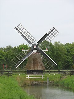
| Nieuwlandsche Poldermolen, Kethel en Spaland 51°55′15″N4°22′40″E / 51.920716°N 4.377738°E | Grondzeiler | A drainage mill was marked on a map of 1560 The grondzeiler here was demolished in 1888 and replaced by a larger mill. [35] |  | |
| Nieuwlandsche Poldermolen, Kethel en Spaland 51°55′15″N4°22′40″E / 51.920716°N 4.377738°E | Grondzeiler | 1888 | This drainage mill was moved here from Ouderkerk aan den IJssel, South Holland. It was burnt down by German forces on 5 October 1944. [36] |  |
| Nieuw Mathenessermolen 51°54′40″N4°24′49″E / 51.911148°N 4.413517°E | Wipmolen | A drainage mill was standing on this site in 1560. [37] | ||
| Nieuw Mathenessermolen 51°54′40″N4°24′49″E / 51.911148°N 4.413517°E | Grondzeiler | 1791 | This drainage mill was demolished in 1923. [38] | |
| Noirtmolen, Noortcoornmolen, Noordmolen 51°55′13″N4°23′52″E / 51.920355°N 4.397691°E | Standerdmolen | A mill stood on this site in 1446. A corn mill that stood here was demolished in 1707, and was replaced by a stellingmolen. [39] | ||
| Noordmolen, Kethel 51°57′31″N4°23′45″E / 51.958613°N 4.395756°E | Unknown | 1576 | A drainage mill here was struck by lightning and burnt down on 6 November 1834. [40] | |
| Noordmolen, Kethel 51°57′31″N4°23′45″E / 51.958613°N 4.395756°E | Grondzeiler | 1834 | This drainage mill was demolished in 1872. It was replaced by a steam-powered pumping station. [40] | |
| Noort Moole 51°55′13″N4°23′52″E / 51.920355°N 4.397691°E | Stellingmolen | 1711 | This was originally a corn mill, later it was a malt mill. It was demolished in 1803 and replaced by a larger mill built 50 metres (55 yd) to the north west. [41] | |
| Oostmolen 51°55′04″N4°24′07″E / 51.917776°N 4.402036°E | Stellingmolen | 1727 | This malt mill was demolished in 1899, leaving a two storey stump which was used as a packhouse for bananas. The stump was demolished in 1962. [42] | |
| Oud Burgemeester Knappert 51°54′26″N4°24′40″E / 51.907263°N 4.411087°E | Stellingmolen | 1862 | A saw mill, the smock was demolished in 1910 when a steam engine took over. The rest was demolished in 1965. [43] | |
| Oud Mathenesserpoldermolen 51°55′27″N4°24′31″E / 51.924169°N 4.408714°E | Wipmolen | A drainage mill was built in 1469. The wipmolen on this site was demolished in 1780 to make way for a grondzeiler. [44] | ||
| Oud Mathenesserpoldermolen 51°55′27″N4°24′31″E / 51.924169°N 4.408714°E | Grondzeiler, later stellingmolen | 1780 | This drainage mill was heightened in 1888. It was demolished in 1910 and replaced by a steam-powered pumping station. [45] | |
| Schravemolen 51°55′50″N4°24′29″E / 51.930509°N 4.407965°E | Grondzeiler | c.1560 | This drainage mill worked until 1897, when a steam engine was built to drain the 's-Gravenlandsepolder. It was subsequently demolished. [46] | |
| 's-Gravelandse polder molen 51°55′35″N4°24′32″E / 51.926408°N 4.408781°E | Wipmolen | A drainage mill was marked on a map dated 1560. It had gone by 1611. [47] | ||
| Suytwintcorenmolen 51°54′51″N4°24′05″E / 51.914193°N 4.401416°E | Standerdmolen | A mill stood on this site in 1383. In 1683, a mill on this site was demolished. It was replaced by De Steenen Molen. [48] | ||
| West Abtsemolen 51°55′55″N4°23′05″E / 51.931813°N 4.384584°E | Grondzeiler | A drainage mill stood on this site in 1479. The mill here was raised in 1739. It was demolished in 1875. [49] | ||
| West Abtsemolen 51°55′55″N4°23′05″E / 51.931813°N 4.384584°E | Grondzeiler | 1875 | This drainage mill was raised in 1893. It was demolished in 1924 and replaced by a diesel-powered pump. The base was left, which survives as a dwelling. [50] |  |
| West Frankenland Poldermolen 51°54′14″N4°24′21″E / 51.903802°N 4.405728°E | Unknown | This mill drained the West Frankenland Polder. It was standing in 1834. [51] | ||
| Westmolen 51°54′59″N4°23′39″E / 51.916505°N 4.394141°E | Standerdmolen | 1580 | This corn mill was replaced by a stellingmolen in 1709. [52] | |
| Westmolen 51°54′59″N4°23′39″E / 51.916505°N 4.394141°E | Stellingmolen | 1711 | This malt mill was demolished in 1869. A steam-powered mill was built on its site in 1870. [53] | |
| Wijk Ten Toorn or Wijk den Toorn 51°54′33″N4°24′20″E / 51.909275°N 4.405579°E | Stellingmolen | 1723 | This sawmill was partly dismantled in 1886-88, and was burnt down in 1912. [54] | |
| Zuidmolen 51°54′42″N4°24′08″E / 51.911629°N 4.402313°E | Stellingmolen | 1717 | This malt and tanning mill was burnt out in 1835. The remains had been demolished by 1846. [55] | |
| Zuidmolen, Kethel 51°57′02″N4°23′42″E / 51.950644°N 4.395088°E | c.1557 | The Zuidmolen was marked on a map dated 1557. It was destroyed in 1574. [56] | ||
| Zuidmolen, Kethel 51°57′02″N4°23′42″E / 51.950644°N 4.395088°E | 1574 | The mill was built in 1574. It was replaced by a new mill in 1828. [56] | ||
| Zuidmolen, Kethel 51°57′02″N4°23′42″E / 51.950644°N 4.395088°E | Grondzeiler | 1828 | The drainage mill was built in 1828. It ceased to work in 1884. The smock burnt down on 13 April 1954, leaving a single storey base used as a house. This was demolished on 19 September 2005 and a new two-storey octagonal house built on the site. [56] |