Listed buildings in Matlock Bath

Last updated

Matlock Bath is a civil parish in the Derbyshire Dales district of Derbyshire, England. The parish contains 44 listed buildings that are recorded in the National Heritage List for England. Of these, three are listed at Grade II*, the middle of the three grades, and the others are at Grade II, the lowest grade. The parish contains the village of Matlock Bath and the surrounding area. The listed buildings are arranged along the valley of the River Derwent and on the steep hillside to the west. Most of the listed buildings are houses, cottages, shops, and associated structures. The other listed buildings include hotels and public houses, churches, a former cotton mill, an obelisk, a railway station and an associated building, a war memorial, and two telephone kiosks.

Contents

Key

Map all coordinates using: OpenStreetMap  
Download coordinates as: KML
GradeCriteria [1]
II*Particularly important buildings of more than special interest
IIBuildings of national importance and special interest

Buildings

Name and locationPhotographDateNotesGrade
New Bath Hotel
53°06′55″N1°33′40″W / 53.11541°N 1.56109°W / 53.11541; -1.56109 (New Bath Hotel)
New Bath Hotel - Matlock Bath - geograph.org.uk - 539836.jpg
1745The hotel, which has been successively enlarged over the years, is in stone, mostly rendered and whitewashed, on a plinth, with quoins, and slate roofs. There are three storeys and attics, and a square plan with a northwest wing at an angle. The entrance front has seven bays, with an open Doric porch in the centre. In the left bay is a French window, and the other windows are sashes with moulded surrounds, some in the lower two floors with cornices, and some in the middle floor with pediments. On the other fronts are two-storey canted bay windows. The original plunge bath has survived in the basement. [2] [3] II
Cliffe House
53°07′46″N1°33′43″W / 53.12942°N 1.56205°W / 53.12942; -1.56205 (Cliffe House)
c. 1765A stuccoed house with a hipped slate roof. There are three storeys and three bays. On the front is a decorative wrought iron porch, and a doorway with an arched head, quoins, and a semicircular fanlight with Gothic tracery. This is flanked by Venetian windows, and the upper floors contain sash windows. [4] [5] II
Hodgkinson's Hotel
53°07′14″N1°33′49″W / 53.12058°N 1.56365°W / 53.12058; -1.56365 (Hodgkinson's Hotel)
Hodgkinson's Hotel - geograph.org.uk - 2329439.jpg
c. 1772The hotel, which was extended in the 1790s, is stuccoed, on a plinth, and has a slate roof. There are four storeys and three bays. The central doorway has a round arch and a semicircular fanlight, and the windows are sashes with plain surrounds. [2] [6] II
Old Masson House
53°06′46″N1°33′45″W / 53.11290°N 1.56246°W / 53.11290; -1.56246 (Old Masson House)
Late 18th centuryA stone house that was later extended, in stone, with quoins, floor bands, a moulded cornice, and a tile roof. There are two storeys, a main range of three bays, a recessed wing on the right, and a later wing on the left. The doorway has a round-arched head, a moulded surround, an architrave, and a segmental fanlight, and the windows are sashes in architraves. [7] II
Rose Cottage
53°07′16″N1°33′47″W / 53.12114°N 1.56300°W / 53.12114; -1.56300 (Rose Cottage)
Rose Cottage, Matlock Bath.jpg
Late 18th centuryThe cottage, later extended and used for other purposes, is in stone with quoins, and a tile roof. There are two storeys and a symmetrical front of three bays, and an additional bay to the left. The doorway has a round-headed arch and a wheel fanlight, and the windows are sashes in chamfered surrounds. In front of the garden is a stone wall with moulded flat coping. [8] II
Temple Hotel
53°07′15″N1°33′52″W / 53.12088°N 1.56441°W / 53.12088; -1.56441 (Temple Hotel)
Hillside houses, Matlock Bath - geograph.org.uk - 2325847.jpg
1770s (probable)The hotel is in painted stone, with quoins, floor bands, and a slate roof. There are three storeys and an L-shaped plan, with wings of three and four bays. In the angle is a Roman Doric portico, and the windows are sashes with plain surrounds. At the end corner of the left wing is a bay window tiered over three storeys. [2] [9] II
Masson Mill
53°06′45″N1°33′42″W / 53.11263°N 1.56162°W
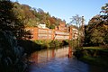
 / 53.11263; -1.56162 (Masson Mill)
Masson Mill, Matlock Bath - geograph.org.uk - 281315.jpg
1783The mill was built in brick with stone dressings by Richard Arkwright, and has been considerably extended. The original building was of five storeys, raised to six in about 1800, and has a front of 21  bays and sides of three bays. The middle three bays project and are surmounted by a cupola, and the windows are a mix of Venetian windows and lunettes. The mill was extended in the early 19th century, and again from 1900, in Accrington brick, including an engine house, a chimney, and an Italianate tower with Art Nouveau features. The mill closed in 1992 and has been converted for other uses. [10] [11] II*
Belle View
53°07′20″N1°33′48″W / 53.12214°N 1.56324°W / 53.12214; -1.56324 (Belle View)
c. 1799A stone house with a floor band, moulded eaves, and a hipped slate roof. There are two storeys, three bays, and a recessed stuccoed single-storey wing on the left. On the front is a large three-light bow window, the other windows are sashes, and in the wing is a doorway with a semicircular head and a fanlight. [4] [12] II
Derwent House
53°07′29″N1°33′33″W / 53.12465°N 1.55929°W / 53.12465; -1.55929 (Derwent House)
Late 18th or early 19th centuryA stone house with a sill band and a tile roof. There are three storeys and a symmetrical front of three bays. The central doorway has a rectangular fanlight and the windows are sashes; all the openings have plain surrounds. [13] II
Lower Towers
53°07′21″N1°33′46″W / 53.12251°N 1.56270°W / 53.12251; -1.56270 (Lower Towers)
1808 or beforeThe house is stuccoed, it in Strawberry Hill style with embattled parapets, and has an irregular plan. In the centre is a block with two storeys and two bays, containing windows with ogee heads and Gothic glazing, and a bay window. To its right is a three-storey circular tower, to the left is a recessed wing containing a casement window with Gothic glazing, and at the rear is a five-storey block. [14] [15] II
Dale Cottage
53°07′54″N1°33′35″W / 53.13155°N 1.55967°W / 53.13155; -1.55967 (Dale Cottage)
Dale Cottage, Matlock Bath.jpg
1820A stuccoed house with bold lined eaves and a hipped slate roof. There are two storeys and four bays. The central doorway has a gabled surround, and above it is a moulded panel containing the date. The windows are sashes, those in the upper floor with shutters. [2] [16] II*
136 North Parade
53°07′15″N1°33′48″W / 53.12093°N 1.56326°W / 53.12093; -1.56326 (136 North Parade)
Early 19th centuryA shop in engraved stucco with a slate roof, three storeys and two bays. The ground floor contains a modern shop front, in the middle floor are two three-light canted oriel windows, and the top floor windows have plain architraves. [17] II
138–142 North Parade
53°07′15″N1°33′48″W / 53.12084°N 1.56333°W / 53.12084; -1.56333 (138–142 North Parade)
138-142 North Parade, Matlock Bath.jpg
Early 19th centuryA stuccoed shop in a terrace with a slate roof, three storeys and three bays. The ground floor contains a modern shop front, in the outer bays of the middle floor are three-light canted oriel windows, and the other windows are sashes in plain architraves. [18] II
144 North Parade
53°07′15″N1°33′48″W / 53.12076°N 1.56344°W / 53.12076; -1.56344 (144 North Parade)
144 North Parade, Matlock Bath.jpg
Early 19th centuryA stuccoed shop in a terrace, with moulded eaves and a slate roof. There are three storeys and three bays. The ground floor contains modern shop fronts, in the right bay of the middle floor is a canted oriel window, and the other windows are sashes with painted stone surrounds. [19] II
152–158 South Parade
53°07′14″N1°33′49″W / 53.12048°N 1.56368°W / 53.12048; -1.56368 (152–158 South Parade)
152-158 South Parade, Matlock Bath.jpg
Early 19th centuryA stuccoed shop in a terrace, with a slate roof, four storeys and two bays. The ground floor contains a modern shop front, and in the upper floors are sash windows with plain surrounds. [20] II
160–168 South Parade
53°07′13″N1°33′49″W / 53.12038°N 1.56366°W / 53.12038; -1.56366 (160–168 South Parade)
160-168 South Parade, Matlock Bath.jpg
Early 19th centuryA stuccoed shop in a terrace, with a tile roof, three storeys and four bays. The ground floor contains a modern shop front, and in the upper floors are sash windows with plain surrounds. [21] II
170–172 South Parade
53°07′13″N1°33′49″W / 53.12028°N 1.56367°W / 53.12028; -1.56367 (170–172 South Parade)
170-172 South Parade, Matlock Bath.jpg
Early 19th centuryA stuccoed shop in a terrace, with false quoins and a tile roof. There are three storeys and four bays. In the ground floor is a modern shop front, and a recessed doorway with a rectangular fanlight on the right. In the central two bays of the middle floor is a large wooden bay window, and the other windows are sash windows with plain surrounds. [22] II
178 and 180 South Parade
53°07′12″N1°33′49″W / 53.12010°N 1.56364°W / 53.12010; -1.56364 (178 and 180 South Parade)
178-180 South Parade, Matlock Bath.jpg
Early 19th centuryA stuccoed shop in a terrace, with a slate roof, four storeys and two bays. The ground floor contains a modern shop front, and in the upper floors are sash windows with plain surrounds. [23] II
182 South Parade
53°07′12″N1°33′49″W / 53.12003°N 1.56361°W / 53.12003; -1.56361 (182 South Parade)
Early 19th centuryA stuccoed shop in a terrace with moulded stuccoed eaves and a slate roof. There are two storeys and three bays. The ground floor contains a modern shop front, and in the upper floor are sash windows. [24] II
184 and 186 South Parade
53°07′12″N1°33′49″W / 53.11992°N 1.56358°W / 53.11992; -1.56358 (184 and 186 South Parade)
Early 19th centuryA stuccoed shop at the end of a terrace, with moulded stuccoed eaves, and a slate roof, hipped on the left. There are two storeys and four bays. In the ground floor is a late 19th-century shop front, the upper floor contains sash windows, and in the left return is a round-headed window. [25] II
High Tor Hotel
53°07′47″N1°33′37″W / 53.12974°N 1.56021°W / 53.12974; -1.56021 (High Tor Hotel)
Matlock - High Tor Hotel from High Tor - geograph.org.uk - 2041005.jpg
Early 19th centuryThe hotel, in cottage orné style, is stuccoed, with bold eaves and a slate roof with decorative bargeboards. There are two storeys, three gabled bays, and a recessed two-bay wing on the right. On the front is a gabled rustic porch, and the windows have chamfered surrounds and Gothic cast iron glazing bars. [2] [26] II
Hillside
53°07′20″N1°33′50″W / 53.12218°N 1.56396°W / 53.12218; -1.56396 (Hillside)
Early 19th centuryA stuccoed house with a slate roof. There are storeys, three bays, and a recessed wing on the right with a lean-to roof. In the centre is a tall sash window, flanked by oriel windows each with a moulded underhang, a cornice, and a swept pentice roof. The doorway has a plain surround, and in the wing is a window with a pointed arch. [27] II
Former Princess Victoria
53°07′13″N1°33′49″W / 53.12018°N 1.56364°W / 53.12018; -1.56364 (Former Princess Victoria)
Princess Victoria - South Parade - geograph.org.uk - 3133115.jpg
Early 19th centuryThe public house is stuccoed and has a slate roof. There are four storeys and two bays. In the ground floor is a 19th-century shop front, the first floor contains two bay windows, and the top two floors contain sash windows. [28] II
Round House
53°07′20″N1°33′44″W / 53.12230°N 1.56232°W / 53.12230; -1.56232 (Round House)
The Round House - Waterloo Road - geograph.org.uk - 2325975.jpg
Early 19th centuryA stone house with a hexagonal plan, a single storey, and a slate roof with bold eaves. The doorway and the windows have pointed heads, and the windows contain Gothic glazing bars. [14] [29] II
The Rocks
53°07′56″N1°33′34″W / 53.13213°N 1.55938°W / 53.13213; -1.55938 (The Rocks)
The Rocks, Shining Cliff.jpg
Early 19th centuryA house, later divided into two, in cottage orné style. It is stuccoed, with bold lined eaves, and a slate roof with ornamental bargeboards. There are two storeys, a main block of five bays, the outer bays projecting and gabled, a single-bay wing on the right, and a rear wing. The outer bays have canted bay windows, most of the other windows are sashes, in the right wing is a balcony over an arcaded loggia, and on the left is a conservatory. [30] [31] II
The Ruskin Hall
53°07′48″N1°33′37″W / 53.13003°N 1.56041°W / 53.13003; -1.56041 (The Ruskin Hall)
Matlock - High Tor Hotel from High Tor - geograph.org.uk - 2041005.jpg
Early 19th centuryOriginally the servants' hall to Tor House, later High Tor Hotel, it is stuccoed, and has false quoins, bold eaves, and a slate roof with bargeboards. There are two storeys, the gable end faces the road, and the windows are sashes. [32] II
Obelisk
53°07′06″N1°33′44″W / 53.11847°N 1.56212°W / 53.11847; -1.56212 (Obelisk)
Obelisk, bottom of Temple Road - geograph.org.uk - 2331813.jpg
1820sThe obelisk, which stands at a road junction, is in gritstone. It consists of a tapering shaft in two pieces, about 3.5 metres (11 ft) high. On three sides of the shaft, it is inscribed "TEMPLE HOTEL". [33] II
Upper Tower
53°07′24″N1°33′53″W / 53.12345°N 1.56465°W / 53.12345; -1.56465 (Upper Tower)
Upper Tower, Matlock Bath.jpg
c. 1830A house in the form of a castle, it is stuccoed and has two storeys. There is a rectangular plan and a recessed wing on the right. On the front are two three-storey circular towers with embattled parapets, and at the rear is a taller tower. The main block has sash window, in the towers are windows with pointed heads and Gothic glazing bars, and in the wing is a window with a small balcony. [14] [34] II
Woodland Terrace
53°06′54″N1°33′36″W / 53.11513°N 1.55990°W
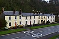
 / 53.11513; -1.55990 (Upper Tower)
Woodland Terrace, Matlock Bath.jpg
Early to mid 19th centuryThe terrace of four stuccoed houses with slate roofs. There are two storeys, each house has three bays, and all the windows are sashes. The left two houses have round-headed doorways with moulded surrounds, wheel fanlights, and keystones. The other houses have pilasters, rectangular fanlights, and moulded cornice hoods on consoles. [35] II
50–62 North Parade
53°07′19″N1°33′39″W / 53.12181°N 1.56070°W
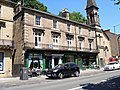
 / 53.12181; -1.56070 (50–62 North Parade)
50-62 North Parade, Matlock Bath.jpg
c. 1840A row of stone shops with a sill band, a modillion eaves cornice, and a hipped slate roof. There are three storeys and five bays. The ground floor contains 19th-century shop fronts, in the middle floor are tall casement windows with architraves, cornice hoods, and foliated consoles. In front of the middle floor is a wrought iron balcony, and in the top floor are sash windows with plain surrounds. [36] II
64–70 North Parade
53°07′18″N1°33′40″W / 53.12179°N 1.56101°W / 53.12179; -1.56101 (64–70 North Parade)
64-70 North Parade, Matlock Bath.jpg
c. 1840A row of stone shops with a sill band, a modillion eaves cornice, and a hipped slate roof. There are three storeys and six bays. In the round floor is a doorway and a three-light window, and to the left are 19th-century shop fronts. The middle floor contains tall casement windows with architraves, and cornice hoods on consoles, and in front of them is a wrought iron balcony. The top floor contains sash windows with plain surrounds. [37] II
Holy Trinity Church
53°07′03″N1°33′41″W / 53.11738°N 1.56134°W / 53.11738; -1.56134 (Holy Trinity Church)
Matlock Bath - Holy Trinity Church - geograph.org.uk - 822229.jpg
1841–42The church, designed by Weightman and Hadfield in Decorated style, was enlarged in 1873–74. It is built in gritstone with freestone dressings and slate roofs. The church consists of a nave, a south aisle, a north porch, north and south transepts, a chancel with a north organ chamber and a south vestry, and a west steeple. The steeple has a tower with three stages, buttresses, a three-light west window, clock faces, two-light bell openings, crocketed pinnacles, an embattled parapet, and a recessed crocketed octagonal spire. [38] [39] II
72–86 Fountain Villas
53°07′18″N1°33′41″W / 53.12180°N 1.56143°W / 53.12180; -1.56143 (72–86 Fountain Villas)
72-86 Fountain Villas, Matlock Bath.jpg
c. 1845A row of stuccoed stone houses with a hipped slate roof. There are three storeys and six bays. On the front are two Roman Doric porticos and doorways with rectangular fanlights, and the windows are sashes. [2] [40] II
Belmont
53°07′20″N1°33′49″W / 53.12218°N 1.56356°W / 53.12218; -1.56356 (Belmont)
1847A stuccoed house with two storeys, two bays, and a gable containing a quatrefoil-shaped plaque with the date. In the centre of the front is a doorway and a wooden gabled porch, and the windows are sashes. [41] II
Matlock Bath railway station
53°07′21″N1°33′25″W / 53.12240°N 1.55692°W / 53.12240; -1.55692 (Matlock Bath railway station)
2019 at Matlock Bath station - exterior.JPG
1849The station was built by the Manchester, Buxton, Matlock and Midland Junction Railway in Swiss chalet style. It is timber framed with herringbone brick infill, and has a tile roof with overhanging bracketed eaves. There is a single storey, and eight bays, the middle two bays projecting and gabled. The doorway is in the centre, and the windows are mullioned and contain cast iron Gothic glazing bars. [42] [43] II
Northern building,
Matlock Bath railway station
53°07′22″N1°33′25″W / 53.12280°N 1.55707°W / 53.12280; -1.55707 (Northern building, Matlock Bath railway station)
Matlock Bath - Station Platform Building - geograph.org.uk - 823244.jpg
c. 1849The building was erected by the Manchester, Buxton, Matlock and Midland Junction Railway in Swiss chalet style. It is timber framed with herringbone brick infill, and has a tile roof with overhanging bracketed eaves. There is a single storey, and four bays, the outer bays projecting and gabled. There are two doorways in the middle two bays, and the windows are mullioned and contain cast iron Gothic glazing bars. [42] [44] II
92–98 Fountain Villas
53°07′18″N1°33′43″W / 53.12176°N 1.56183°W
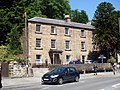
 / 53.12176; -1.56183 (92–98 Fountain Villas)
92-98 Fountain Villas, Matlock Bath.jpg
c. 1850A row of stone houses with quoins and a hipped slate roof. There are three storeys and six bays. On the front are two Roman Doric porticos and doorways with rectangular fanlights, and the windows are sashes. [2] [45] II
134 North Parade
53°07′16″N1°33′47″W / 53.12099°N 1.56317°W / 53.12099; -1.56317 (134 North Parade)
134 North Parade, Matlock Bath.jpg
Mid 19th centuryA stuccoed shop at the end of a terrace, with three storeys, three bays, and a two-storey single-bay extension on the right. The ground floor contains a modern shop front, the windows in the main range have two lights, and the window in the extension has three. [46] II
148 North Parade
53°07′14″N1°33′49″W / 53.12069°N 1.56350°W / 53.12069; -1.56350 (148 North Parade)
148 North Parade - Talisman - geograph.org.uk - 2326959.jpg
Mid 19th centuryA building at the end of a terrace, with three storeys, the ground floor in stone with four bays, and the upper floors stuccoed with three bays. It has a floor band, modillion eaves, and a slate roof. In the ground floor is a doorway with a cornice hood on consoles. The windows are sashes, those in the upper two floors with keystones. [47] II
Methodist Church
53°07′19″N1°33′38″W / 53.12190°N 1.56045°W / 53.12190; -1.56045 (Methodist Church)
Methodist Church, Matlock Bath.jpg
1866–67The church, later used for other purposes, is in stone with quoins, and consists of a nave and a chancel. The front facing the road has a dentilled gable, and contains three giant arches, the middle arch with a doorway and a window above, and the outer arches with round-headed windows, all with hood moulds. Above there are three circular windows. To the left is a tower with three stages, the lowest stage rusticated. Above is a round-headed window, round-headed bell openings, and a short pyramidal spire. [48] [49] II
Cromford Court
53°06′43″N1°33′50″W / 53.11194°N 1.56401°W / 53.11194; -1.56401 (Cromford Court)
Cromford Court - geograph.org.uk - 3413132.jpg
1901A large house later used for other purposes, it is in stone with rendered brick and timber framing, on a chamfered plinth, with a moulded floor band, and a tile roof with overhanging eaves and ornate bargeboards. There are two storeys and attics, and all the windows are casements. Features include canted bay windows, an oriel window, an octagonal turret with a copper spire, and an entrance archway. [10] [50] II
War memorial
53°07′18″N1°33′33″W / 53.12174°N 1.55903°W / 53.12174; -1.55903 (War memorial)
War memorial - small park - North Parade - Matlock Bath (15095711948).jpg
1921The war memorial in Memorial Park consists of a sculpture in Carrara marble on a pedestal of Cornish grey granite. The sculpture depicts a soldier and a sailor standing across a cairn, holding a flag. The pedestal consists of a pillar with a moulded and dentilled cornice and base and corner pilasters, on a plinth with a laurel wreath in relief. This stands on a stepped base and the memorial is surrounded by a low circular kerb. On the pedestal are inscriptions and the names of those lost in the two World Wars. [48] [51] II*
Telephone kiosk, North Parade
53°07′18″N1°33′38″W / 53.12176°N 1.56051°W / 53.12176; -1.56051 (Telephone kiosk, North Parade)
Phone box (Listed).jpg
1935The K6 type telephone kiosk was designed by Giles Gilbert Scott. Constructed in cast iron with a square plan and a dome, it has three unperforated crowns in the top panels. [52] II
Telephone kiosk, South Parade
53°07′11″N1°33′48″W / 53.11969°N 1.56322°W / 53.11969; -1.56322 (Telephone kiosk, South Parade)
1935The K6 type telephone kiosk was designed by Giles Gilbert Scott. Constructed in cast iron with a square plan and a dome, it has three unperforated crowns in the top panels. [53] II

Related Research Articles

Dronfield is a civil parish in the North East Derbyshire district of Derbyshire, England. The parish contains 44 listed buildings that are recorded in the National Heritage List for England. Of these, one is listed at Grade I, the highest of the three grades, four are at Grade II*, the middle grade, and the others are at Grade II, the lowest grade. The parish contains the town of Dronfield, the district of Dronfield Woodhouse, the village of Coal Aston, and the surrounding area. Most of the listed buildings are houses, cottages and associated structures, farmhouses and farm buildings. The other listed buildings include churches, a churchyard cross, public houses, a former school, a milestone, a monument, and a bridge.

Barlborough is a civil parish in the Bolsover district of Derbyshire, England. The parish contains 29 listed buildings that are recorded in the National Heritage List for England. Of these, one is listed at Grade I, the highest of the three grades, six are at Grade II*, the middle grade, and the others are at Grade II, the lowest grade. The parish contains the village of Barlborough and the surrounding area. The listed buildings include two country houses, smaller houses and associated structures, a church, a village cross, farmhouses and farm buildings, a former almshouse, two monuments in a garden, the walls of a burial ground, a memorial gateway, and a school.

Baslow and Bubnell is a civil parish in the Derbyshire Dales district of Derbyshire, England. The parish contains 30 listed buildings that are recorded in the National Heritage List for England. Of these, one is listed at Grade I, the highest of the three grades, one is at Grade II*, the middle grade, and the others are at Grade II, the lowest grade. The parish contains the villages of Baslow and Bubnell, and the surrounding countryside and moorland. Most of the listed buildings are houses, cottages and associated structures. The other listed buildings include a church and items in the churchyard, bridges, including a clapper bridge, a hotel, guide posts and guide stones, mile posts and a milestone, a boundary stone, a monument, and a telephone kiosk.

Bonsall is a civil parish in the Derbyshire Dales district of Derbyshire, England. The parish contains 13 listed buildings that are recorded in the National Heritage List for England. Of these, two are listed at Grade II*, the middle of the three grades, and the others are at Grade II, the lowest grade. The parish contains the village of Bonsall and the surrounding area. The listed buildings consist of houses, cottages and associated structures, a farmhouse and an outbuilding, a market cross, two churches, a public house, a sawmill converted for residential use, and a telephone kiosk.

Bretby is a civil parish in the South Derbyshire district of Derbyshire, England. The parish contains 13 listed buildings that are recorded in the National Heritage List for England. Of these, two are listed at Grade II*, the middle of the three grades, and the others are at Grade II, the lowest grade. The parish contains the village of Bretby and the surrounding countryside. The listed buildings include houses, cottages and associated structures, a farmhouse and farm buildings, a church, a former school, a former watermill, a bottle kiln and factory, a war memorial and village pump, and a telephone kiosk.

Castleton is a civil parish in the High Peak district of Derbyshire, England. The parish contains 25 listed buildings that are recorded in the National Heritage List for England. Of these, one is listed at Grade I, the highest of the three grades, one is at Grade II*, the middle grade, and the others are at Grade II, the lowest grade. The parish contains the village of Castleton and the surrounding countryside and moorland. The most important building in the parish is the ruined Peveril Castle, which is listed at Grade I. The other listed buildings include houses, cottages and associated structures, farmhouses and farm buildings, a church and a sundial in the churchyard, a hotel and a public house, a former watermill, three mileposts, a school, a war memorial, and a telephone kiosk.

Crich is a civil parish in the Amber Valley district of Derbyshire, England. The parish contains 52 listed buildings that are recorded in the National Heritage List for England. Of these, one is listed at Grade I, the highest of the three grades, one is at Grade II*, the middle grade, and the others are at Grade II, the lowest grade. The parish contains the villages of Crich, Fritchley, Whatstandwell, and Wheatcroft, and the surrounding countryside. Most of the listed buildings are houses, cottages and associated structures, farmhouses and farm buildings. In the parish is the National Tramway Museum, and a number of structures that have been moved from other sites to the museum are listed. The other listed buildings include churches and chapels, a bridge over the Cromford Canal and a road bridge over the River Derwent, public houses, buildings associated with tramways, a milepost, a village cross, a memorial tower, and a village telephone kiosk.

Darley Dale is a civil parish in the Derbyshire Dales district of Derbyshire, England. The parish contains 27 listed buildings that are recorded in the National Heritage List for England. Of these, three are listed at Grade II*, the middle of the three grades, and the others are at Grade II, the lowest grade. The parish contains the town of Darley Dale and the surrounding area. Most of the listed buildings are houses, cottages and associated structures, farmhouses and farm buildings. The other listed buildings include a church and its former rectory, a road bridge over the River Derwent, public houses, a mile post and a milestone, buildings associated with Darley Dale railway station, an institute, and a school.

Edensor is a civil parish in the Derbyshire Dales district of Derbyshire, England. The parish contains 50 listed buildings that are recorded on the National Heritage List for England. Of these, one is listed at Grade I, the highest of the three grades, six are at Grade II*, the middle grade, and the others are at Grade II, the lowest grade. The parish contains the model village of Edensor, which was created by Joseph Paxton for the 6th Duke of Devonshire, and the surrounding area. Most of the listed buildings are houses, cottages and associated structures, mainly within the village. The other listed buildings include a church, a cross and a tomb in the churchyard, a guidestone, a bridge, a former cotton mill, a hotel and a stable block converted for other uses, an ornamental fountain, a water trough, the wall and railings enclosing the village, and a telephone kiosk.

Buxton is a spa town in the High Peak district of Derbyshire, England. The town contains 93 listed buildings that are recorded in the National Heritage List for England. Of these, one is listed at Grade I, the highest of the three grades, seven are at Grade II*, the middle grade, and the others are at Grade II, the lowest grade. That the town was a source of natural water springs has been known at least since Roman times, and during the medieval period, St Ann's Well was a shrine and a place of pilgrimage. Buxton developed into a spa town during the 18th and 19th centuries, largely under the influence of the Dukes of Devonshire. The water was considered to have curative powers, and this led to the building of bath houses and later a hospital. Later, leisure facilities grew, and were served by the Pavilion Gardens, and the building of a conservatory, a theatre, a concert hall, and an opera house.

Glossop is a market town in the High Peak district of Derbyshire, England. The town and surrounding areas, which include Dinting and Old Glossop, contain 56 listed buildings that are recorded in the National Heritage List for England. All the listed buildings are designated at Grade II, the lowest of the three grades, which is applied to "buildings of national importance and special interest". The town originated in what is now Old Glossop, where the older buildings are to be found, and in the 19th century its centre moved to the southwest, into the area known as New Glossop, or Howard Town centred around Norfolk Square. Most of the listed buildings are houses, cottages and farmhouses and associated structures, and the others include churches and items in churchyards, chapels, some of which have been converted for other uses, shops, public houses, public buildings, a market cross, a drinking trough, a former cotton mill, a railway station, a school, a bank, a theatre, a war memorial, and a pair of telephone kiosks.

Hognaston is a civil parish in the Derbyshire Dales district of Derbyshire, England. The parish contains nine listed buildings that are recorded in the National Heritage List for England. Of these, one listed at Grade II*, the middle of the three grades, and the others are at Grade II, the lowest grade. The parish contains the village of Hognaston and the surrounding area. The listed buildings consist of houses, cottages, farmhouses, a church, and a telephone kiosk.

Matlock Town is a civil parish in the Derbyshire Dales district of Derbyshire, England. The parish contains 44 listed buildings that are recorded in the National Heritage List for England. Of these, six are listed at Grade II*, the middle of the three grades, and the others are at Grade II, the lowest grade. The parish contains the town of Matlock and the surrounding area. Most of the listed buildings are houses, cottages and associated structures, farmhouses and farm buildings. During the middle of the 19th century, Matlock became a centre for hydrotherapy, and buildings known as hydros were built for this purpose. Two of the larger hydros have survived and are listed. The other listed buildings include churches, a chapel, items in a churchyard, public houses, bridges, a former malthouse, a bank, a milestone, a former smithy, and a war memorial.

Old Bolsover is a civil parish in the Bolsover District of Derbyshire, England. The parish contains 55 listed buildings that are recorded in the National Heritage List for England. Of these, one is listed at Grade I, the highest of the three grades, six are at Grade II*, the middle grade, and the others are at Grade II, the lowest grade. The parish contains the market town of Bolsover and the surrounding area, including the village of Shuttlewood. The older part of the town has been a market town since the medieval period, and the area of New Bolsover is a model village built between 1888 and 1893 for colliery workers. A row of six semi-detached houses was built for the managers, over 200 houses were built for the other workers in terraces forming three sides of a quadrangle, and community buildings were also erected. All these buildings are listed. The most prominent building in the parish is Bolsover Castle, a country house in the style of a castle, which is listed, together with associated structures, including five conduit houses. Most of the other listed buildings are houses, cottages, shops and associated structures, farmhouses and farm buildings. The rest include a church, a chapel, a former windmill and a nearby chimney, a war memorial, a school and a telephone kiosk.

Osmaston is a civil parish in the Derbyshire Dales district of Derbyshire, England. The parish contains 21 listed buildings that are recorded in the National Heritage List for England. Of these, one is listed at Grade II*, the middle of the three grades, and the others are at Grade II, the lowest grade. The parish contains the village of Osmaston and the surrounding area. The country house, Osmaston Manor, was built in the 1840s, and has been largely demolished, but its gardens and grounds contain listed buildings, including garden features, cottages and boat houses. The other listed buildings are houses, cottages and associated structures, a church, a school, a war memorial, and a telephone kiosk.

Over Haddon is a civil parish in the Derbyshire Dales district of Derbyshire, England. The parish contains eight listed buildings that are recorded in the National Heritage List for England. All the listed buildings are designated at Grade II, the lowest of the three grades, which is applied to "buildings of national importance and special interest". The parish contains the village of Over Haddon and the surrounding countryside. The listed buildings consist of three farmhouses and associated structures, a former cotton mill and sluice gate, a footbridge over the River Lathkill, a house, a church, and a telephone kiosk.

Repton is a civil parish in the South Derbyshire district of Derbyshire, England. The parish contains 53 listed buildings that are recorded in the National Heritage List for England. Of these, six are listed at Grade I, the highest of the three grades, one is at Grade II*, the middle grade, and the others are at Grade II, the lowest grade. The parish contains the village of Repton, the smaller village of Milton, and the surrounding area. The major complex of buildings is associated with Repton School, built on the site of an earlier priory. Many of these are listed, four of them at Grade I. The other Grade I listed buildings are St Wystan's Church and the market cross. Most of the other listed buildings are houses, cottages and associated structures, the earlier ones timber framed, and the later ones in red brick. The rest of the listed buildings include farmhouses and farm buildings, bridges, a water management system, a war memorial, and a telephone, kiosk.

South Darley is a civil parish in the Derbyshire Dales district of Derbyshire, England. The parish contains nine listed buildings that are recorded in the National Heritage List for England. Of these, one is listed at Grade I, the highest of the three grades, and the others are at Grade II, the lowest grade. The parish contains the villages of Darley Bridge, Snitterton and Wensley, and the surrounding countryside. The listed buildings consist of houses and associated structures, a public house, a church, a milestone and a telephone kiosk.

Youlgreave is a civil parish in the Derbyshire Dales district of Derbyshire, England. The parish contains 57 listed buildings that are recorded in the National Heritage List for England. Of these, one is listed at Grade I, the highest of the three grades, one is at Grade II*, the middle grade, and the others are at Grade II, the lowest grade. The parish contains the village of Youlgreave, the hamlet of Alport and the surrounding countryside. Most of the listed buildings are houses, cottages and associated structures, farmhouses and farm buildings. The other listed buildings include a church and associated structures, a public house, bridges, a milestone, a conduit head, a school, a youth hostel and a telephone kiosk.

<span class="mw-page-title-main">Matlock Bath War Memorial</span> Historic site in Derbyshire, England

Matlock Bath War Memorial is a 20th-century grade II* listed war memorial in Matlock Bath, Derbyshire.

References

Citations

  1. Historic England
  2. 1 2 3 4 5 6 7 Hartwell, Pevsner & Williamson (2016), p. 510
  3. Historic England & 1423239
  4. 1 2 Hartwell, Pevsner & Williamson (2016), p. 511
  5. Historic England & 1248140
  6. Historic England & 1248065
  7. Historic England & 1247936
  8. Historic England & 1278062
  9. Historic England & 1248235
  10. 1 2 Hartwell, Pevsner & Williamson (2016), p. 289
  11. Historic England & 1247935
  12. Historic England & 1248241
  13. Historic England & 1263897
  14. 1 2 3 Hartwell, Pevsner & Williamson (2016), p. 509
  15. Historic England & 1248008
  16. Historic England & 1247891
  17. Historic England & 1248063
  18. Historic England & 1278063
  19. Historic England & 1248064
  20. Historic England & 1248066
  21. Historic England & 1278065
  22. Historic England & 1248067
  23. Historic England & 1248068
  24. Historic England & 1248069
  25. Historic England & 1248093
  26. Historic England & 1263896
  27. Historic England & 1248239
  28. Historic England & 1278066
  29. Historic England & 1248242
  30. Hartwell, Pevsner & Williamson (2016), pp. 510–511
  31. Historic England & 1248193
  32. Historic England & 1247892
  33. Historic England & 1248491
  34. Historic England & 1248237
  35. Historic England & 1247937
  36. Historic England & 1248059
  37. Historic England & 1248060
  38. Hartwell, Pevsner & Williamson (2016), p. 507
  39. Historic England & 1248232
  40. Historic England & 1278061
  41. Historic England & 1248240
  42. 1 2 Hartwell, Pevsner & Williamson (2016), pp. 508–509
  43. Historic England & 1247893
  44. Historic England & 1245796
  45. Historic England & 1248061
  46. Historic England & 1248062
  47. Historic England & 1278064
  48. 1 2 Hartwell, Pevsner & Williamson (2016), p. 508
  49. Historic England & 1248012
  50. Historic England & 1272275
  51. Historic England & 1451237
  52. Historic England & 1277946
  53. Historic England & 1277909

Sources