Widnes is an industrial town in the Borough of Halton, Cheshire, England, on the north bank of the River Mersey where it narrows at Runcorn Gap. The town contains 24 buildings that are recorded in the National Heritage List for England as designated listed buildings. Of these, 5 are classified at Grade II*, and the rest are at Grade II; Widnes has no Grade I listed buildings. In the United Kingdom, the term "listed building" refers to a building or other structure officially designated as being of special architectural, historical, or cultural significance. Listed buildings are categorised in three grades: Grade I consists of buildings of outstanding architectural or historical interest; Grade II* includes particularly significant buildings of more than local interest; Grade II consists of buildings of special architectural or historical interest. Buildings in England are listed by the Secretary of State for Culture, Media and Sport on recommendations provided by English Heritage, which also determines the grading.
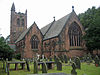
Grappenhall and Thelwall is a civil parish in the borough of Warrington and the ceremonial county of Cheshire, England, and includes the villages of Grappenhall and Thelwall. The Bridgewater Canal and the A56 road pass through Grappenhall and to the south of Thelwall in an east-west direction, and the A50 road runs in a north-south direction between them. Within the parish are 30 buildings that are recorded in the National Heritage List for England as designated listed buildings. Of these, one is listed at Grade I, the highest of the three grades, and the other 28 at Grade II, the lowest grade. The Grade I listed building is a church dating back to the 12th century. The Grade II listed buildings comprise a variety of structures, including another church, houses, aqueducts, bridges, a public house, farm buildings, stocks, a sundial, a milepost, a mounting block, a war memorial, and a telephone kiosk.
Penketh is a civil parish in the Borough of Warrington in Cheshire, England. It contains six buildings that are recorded in the National Heritage List for England as designated listed buildings, all of which are at Grade II. This grade is the lowest of the three gradings given to listed buildings and is applied to "buildings of national importance and special interest". The parish is mainly residential, with some farming, The River Mersey runs through the parish, the Manchester Ship Canal runs along the southern boundary, and the A562 road ends within it.
Stretton is a civil parish in the Borough of Warrington in Cheshire, England. It contains nine buildings that are recorded in the National Heritage List for England as designated listed buildings, all of which are listed at Grade II. This grade is the lowest of the three gradings given to listed buildings and is applied to "buildings of national importance and special interest". The M56 motorway runs through the parish in an east-west direction, and the A49 road runs in a north-south direction. The northern part of the parish is residential, and the rest is mainly rural. Apart from St Matthew's Church and a milestone, the listed buildings are related either to houses or to farming.
Croft is a village and civil parish in the Borough of Warrington in Cheshire, England, north of the town of Warrington. It contains 13 buildings that are recorded in the National Heritage List for England as designated listed buildings. All of these are listed at Grade II, the lowest of the three gradings given to listed buildings, applied to "buildings of national importance and special interest". The parish is mainly rural, and other than a milestone its listed buildings are related to churches, houses or farms.
Winwick is a village and civil parish in the Borough of Warrington in Cheshire, England, north of the town of Warrington. It contains 16 buildings that are recorded in the National Heritage List for England as designated listed buildings. The parish is partly residential and partly rural. The listed buildings include two churches, a holy well, two milestones, and a mounting block. The other structures are houses, farms, or buildings related to them.
Poulton-with-Fearnhead is a civil parish in the Borough of Warrington in Cheshire, England, containing suburbs to the north and east of the town of Warrington. It contains nine buildings that are recorded in the National Heritage List for England as designated listed buildings, all of which are at Grade II. This is the lowest of the three gradings given to listed buildings, applied to "buildings of national importance and special interest". The parish is almost entirely residential, and includes the Warrington suburbs of Padgate, Fearnhead, Cinnamon Brow, Blackbrook, Longbarn, Bruche and Paddington. The listed buildings are all residential, or related to former farms, other than a church and a milestone.
Rixton-with-Glazebrook is a civil parish in the Borough of Warrington in Cheshire, England, to the east of the town of Warrington. It contains seven buildings that are recorded in the National Heritage List for England as designated listed buildings, all of which are listed at Grade II. This grade is the lowest of the three gradings given to listed buildings, applied to "buildings of national importance and special interest". The parish is largely rural, and contains the villages of Hollins Green and Glazebrook. The A57 road runs through the parish, and three of the listed buildings are milestones along this road. The other listed buildings are a church, a war memorial, a railway station, and a former manor house.
Woolston is a civil parish in the Borough of Warrington in Cheshire, England, and is a suburb to the east of the town of Warrington. It contains four buildings that are recorded in the National Heritage List for England as designated listed buildings, all of which are listed at Grade II. This is the lowest of the three gradings given to listed buildings, applied to "buildings of national importance and special interest". The parish is almost entirely residential, and the A57 road runs through it. One of the listed buildings is a milestone on the road, and the others are a church, a pair of cottages, and a single cottage.
Burtonwood and Westbrook is a civil parish in the Borough of Warrington in Cheshire, England, northwest of the town of Warrington. It contains eight buildings that are recorded in the National Heritage List for England as designated listed buildings. The parish includes the village of Burtonwood, and Westbrook, a suburb of the town of Warrington; otherwise it is rural. The original Liverpool to Manchester railway line runs through the north of the parish, and provides it with its only Grade I listed structure, the Sankey Viaduct. The other listed buildings are a church, two country houses, a gatehouse, and four farmhouses.
Great Sankey is a civil parish in the Borough of Warrington in Cheshire, England, and is a suburb to the west of the town of Warrington. It contains seven buildings that are recorded in the National Heritage List for England as designated listed buildings, all of which are at Grade II. This is the lowest of the three gradings given to listed buildings, applied to "buildings of national importance and special interest". The parish is almost completely residential. The listed buildings consist of a church and a sundial in its churchyard, a railway station, a mounting block, a former pillbox, and two milestones.
Warrington is a town, borough and unitary authority area of Cheshire, England. The unitary authority contains 18 civil parishes, which are distributed around its periphery. Its central area, including the town, is unparished. This list contains the 141 structures in the unparished area that are designated by English Heritage as listed buildings and included in the National Heritage List for England. Of these, three buildings are listed at Grade I, and ten at Grade II*. The remaining buildings are listed at Grade II. The listed buildings in the civil parishes are included in separate lists.
There are over 9,000 Grade I listed buildings and 20,000 Grade II* listed buildings in England. This page is a list of these buildings in the unitary authority of Warrington in Cheshire, including the town of Warrington and 18 other civil parishes.
Rainhill is a civil parish in St Helens, Merseyside, England. It contains 20 buildings that are recorded in the National Heritage List for England as designated listed buildings. Of these, two are listed at Grade II*, the middle of the three grades, and the others are at Grade II, the lowest grade. The parish was originally rural, and within it was a coaching stop on the turnpike road between Liverpool and Warrington. Following the arrival of the Liverpool and Manchester Railway in the 1830s, the settlements of Rainhill and Rainhill Stoops grew, and merged to become a dormitory residential area. The listed buildings include farmhouses and farm buildings, and large houses that have been converted for later uses. Associated with the railway are its skew bridge and the station. The other listed buildings include churches, a school, an ancient cross, and a water tower.

William Owen was an English architect who practised in Warrington, which was at that time in Lancashire, England. His works were confined to Northwest England. Owen is best known for his collaboration with William Lever in the creation of the soap-making factory and associated model village at Port Sunlight in the Wirral Peninsula. Here he designed the factory, many of the workers' houses, public buildings and the church. Later Owen was joined by his son, Segar, as a partner. On his own, or in partnership, Owen designed houses, churches, banks, public houses, an infirmary, a school, and a concert hall.
Huyton with Roby is a district in the Metropolitan Borough of Knowsley, Merseyside, England. Formerly the civil parish of Hyton-with-Roby, it contains the settlements of Huyton and Roby. The district contains 26 buildings that are recorded in the National Heritage List for England as designated listed buildings. Of these, one is listed at Grade II*, the middle of the three grades, and the others are at Grade II, the lowest grade.
Downholland is a civil parish in the West Lancashire district of Lancashire, England. It contains eight listed buildings that are recorded in the National Heritage List for England. All the listed buildings are designated at Grade II, the lowest of the three grades, which is applied to "buildings of national importance and special interest". The parish contains the villages of Barton, Haskayne and Downholland Cross, and is otherwise rural. The Leeds and Liverpool Canal passes through the parish. Two milestones by the towpath of the canal are listed, and the other listed buildings are houses and associated structures.
Abram is a village in the Metropolitan Borough of Wigan, Greater Manchester, England. The village and the settlement of Platt Bridge contain two listed buildings that are recorded in the National Heritage List for England. Both the listed buildings are designated at Grade II, the lowest of the three grades, which is applied to "buildings of national importance and special interest". The listed buildings are a house and a farmhouse.
Ashton-in-Makerfield is a town in the Metropolitan Borough of Wigan, Greater Manchester, England. It contains ten listed buildings that are recorded in the National Heritage List for England. All the listed buildings are designated at Grade II, the lowest of the three grades, which is applied to "buildings of national importance and special interest". Industry, including coal mining, came to the town in the 19th century, but it is now mainly residential. The older listed buildings consist of farmhouses, a farm building, a chapel and a milestone, and the later ones are churches and associated structures, and a library.
Atherton is a town in the Metropolitan Borough of Wigan, Greater Manchester, England. The town and its suburbs of Howe Bridge and Hindsford contain 17 listed buildings that are recorded in the National Heritage List for England. Of these, four are listed at Grade II*, the middle of the three grades, and the others are at Grade II, the lowest grade.