Little Italy, Arkansas

Last updated

Little Italy, Arkansas
USA Arkansas location map.svg
Red pog.svg
Little Italy, Arkansas
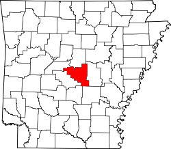
Location of Little Italy in Arkansas
Usa edcp location map.svg
Red pog.svg
Little Italy, Arkansas
Little Italy, Arkansas (the United States)
Coordinates: 34°56′15″N92°35′10″W / 34.93750°N 92.58611°W / 34.93750; -92.58611
CountryUnited States
State Arkansas
Counties Perry
Pulaski
Townships Big Rock Township
Wye Township
Elevation
[1]
692 ft (211 m)
Time zone UTC-6 (Central (CST))
  Summer (DST) UTC-5 (CDT)
ZIP code
72135
72016
Area code +1 (501)
GNIS feature ID51290 [1]
Website http://littleitalyarkansas.com

Established initially as Alta Villa by Italian immigrants in 1915, [2] Little Italy is an unincorporated community in Pulaski and Perry counties in the U.S. state of Arkansas. [1] The culturally rich and historically significant hamlet is located in high terrain along Arkansas Highway 300 amidst the northeastern foothills of the Ouachita Mountains [3] bestriding Wye Mountain [4] and Kryer Mountain. [5] As part of a multi-decade heritage preservation effort, as of 2018 its residents were seeking status as an incorporated municipality. [6]

Contents

See also

Other historically Italian settlements in Arkansas

Catholic Point, Arkansas
Sunnyside Plantation, Arkansas
Tontitown, Arkansas

Related Research Articles

<span class="mw-page-title-main">Pulaski County, Arkansas</span> County in Arkansas, United States

Pulaski County is a county in the U.S. state of Arkansas. With a population of 399,125 as of the 2020 United States Census, it is the most populous county in Arkansas. The county is included in the Little Rock–North Little Rock–Conway metropolitan area. Its county seat is Little Rock, which is also Arkansas's capital and largest city.

<span class="mw-page-title-main">Perry County, Arkansas</span> County in Arkansas, United States

Perry County is a county located in the U.S. state of Arkansas. Its population was 10,019 at the 2020 United States Census. The county seat is Perryville. The county was formed on December 18, 1840, and named for Commodore Oliver Hazard Perry, naval hero in the War of 1812. It is an alcohol prohibition or dry county.

<span class="mw-page-title-main">Wenatchee Mountains</span> Mountain range in Washington, United States

The Wenatchee Mountains are a range of mountains in central Washington State, United States of America. A major subrange of the Cascade Range, extending east 50 miles (80 km) from the Cascade crest, the Wenatchee Mountains separate the drainage basins of the Yakima River from the Wenatchee River. The crest of the range forms part of the boundary between Chelan and Kittitas Counties.

Magnet Cove is a census-designated place (CDP) and former town in Hot Spring County, Arkansas, United States. It is located in the Ouachita Mountains southeast of Hot Springs, on Arkansas Highway 51 north of U.S. Highway 270. As of the 2020 census, the town of Magnet Cove had a population of 692.

Ironton is a small unincorporated community in Pulaski County, Arkansas, United States, to the west of Wrightsville, and near Landmark. Namesakes include Ironton Baptist Church, Ironton Road, and Ironton cut-off. There are a few businesses in Ironton, and a fishing area.

<span class="mw-page-title-main">Shinall Mountain</span> Summit in Pulaski County, Arkansas

Shinall Mountain is a peak in Pulaski County, Arkansas, located in the foothills of the Ouachita Mountains on the western edge of Little Rock, the capital and most populous city of Arkansas. At an elevation of 1,056 feet (322 m) above mean sea level, it is the highest natural point in Pulaski County. Shinall Mountain is made of Carboniferous rocks, and plant fossils can sometimes be found in the blue-hued black shales comprising the sides of its bluff.

<span class="mw-page-title-main">Little Rock, Arkansas</span> Capital and largest city of Arkansas, USA

Little Rock is a city in and the capital of the U.S. state of Arkansas, of which it is also its most populous. The city's population was 202,591 as of the 2020 census. The six-county Little Rock metropolitan area is the 81st-most populous in the United States with 748,031 residents according to the 2020 census.

<span class="mw-page-title-main">Arkansas Highway 300</span> State highway in Arkansas, United States

Highway 300 is a designation for two state highway segments in Central Arkansas. The main route of 34.11 miles (54.89 km) runs from Highway 9/Highway 10 east to Highway 10 in Little Rock. A second segment runs 1.45 miles (2.33 km) east from Interstate 430 as Colonel Glenn Road.

Crystal Hill is an unincorporated community in Hill Township, Pulaski County, Arkansas, United States. It is located along Crystal Hill Road near the junction of Interstate 40 (I-40) and I-430.

East End School District (EESD) is a public school district based in Bigelow, Arkansas, United States. The school district supports more than 650 students in prekindergarten through grade 12 in the 2010–11 school year by employing more than 95 faculty and staff on a full time equivalent basis for its two schools.

Woodyardville is an unincorporated community in Pulaski County, Arkansas, United States.

Conception is an unincorporated community in Highland Township, Wabasha County, Minnesota, United States.

<span class="mw-page-title-main">Pinnacle Mountain (Arkansas)</span> Mountain in Pulaski County, Arkansas

Pinnacle Mountain is a 1,011-foot (308 m) summit and the second-highest natural point in Pulaski County, Arkansas, United States; it is also the primary attraction of the 2,356-acre (953 ha) Pinnacle Mountain State Park. Located in the foothills of the Ouachita Mountains approximately 13 miles (21 km) northwest of downtown Little Rock, Arkansas, Pinnacle Mountain is one of the most iconic landforms of the U.S. Interior Highlands.

Pankey is a formerly unincorporated community in Pulaski County, Arkansas, United States on Arkansas Highway 10. Historically, it was located west of Little Rock, but has since been annexed by the city.

Wye Mountain is a ridge in Perry and Pulaski counties in the U.S. state of Arkansas. It is located in the northeastern foothills of the Ouachita Mountains near Bigelow between the Fourche LaFave and Big Maumelle river valleys.

Kryer Mountain is a ridge in Pulaski county in the U.S. state of Arkansas. It is located in the northeastern foothills of the Ouachita Mountains near Roland between the Arkansas and Big Maumelle river valleys.

Campbellsville is an unincorporated community in Giles County, Tennessee, United States. It is located along Tennessee State Route 166, approximately 11 mi (18 km) northwest of downtown Pulaski, the county seat.

References

  1. 1 2 3 "Little Italy, Arkansas". Geographic Names Information System . United States Geological Survey, United States Department of the Interior . Retrieved March 6, 2018.
  2. Whitworth, Katherine. "It takes a village: The hillside paradise of Arkansas's other Italians". Arkansas Life. November 2011, p. 15.
  3. Dorer, Chris. "Little Italy (Pulaski and Perry Counties)". The Encyclopedia of Arkansas History & Culture. Retrieved March 14, 2018.
  4. "Wye Mountain". Geographic Names Information System . United States Geological Survey, United States Department of the Interior . Retrieved March 13, 2018.
  5. "Kryer Mountain". Geographic Names Information System . United States Geological Survey, United States Department of the Interior . Retrieved March 14, 2018.
  6. "Becoming a Township". Little Italy. Retrieved March 14, 2018.

Further reading