
Altnabreac is a tiny settlement within the county of Caithness, in the north of Scotland, and now within the Highland council area.

Achanalt is a railway halt in Strath Bran, Ross and Cromarty, in the Scottish council area of Highland. It is served by a railway station on the Kyle of Lochalsh Line from Inverness to Kyle of Lochalsh.

Aberchalder is a small settlement and estate at the northern end of Loch Oich in the Scottish Highlands and is in the Highland council area of Scotland. It lies on the A82 road and is situated in two parishes, Boleskine and Kilmonivaig. Fort Augustus is within 5 mi (8.0 km).

Mòruisg is a Scottish mountain situated in the Glencarron and Glenuig Forest, 10 kilometres south west of the village of Achnasheen in the Highland council area.

Achentoul is a hamlet in the Kinbrace area of Sutherland, in the Scottish council area of Highland. Consisting of a few farmhouses and barns, Achentoul lies around 1.5 miles (2.4 km) north of Kinbrace along the A897 road and south of Loch An Ruathair. Although the Achentoul Forest is located in this area, the landscape is said to be dominated by moist Atlantic heather moor.
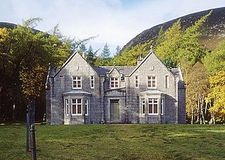
Glas-allt-Shiel is a lodge on the Balmoral Estate by the shore of Loch Muick in Aberdeenshire, Scotland. In its present form it was built in 1868 by Queen Victoria, who called it Glassalt, to be what she called her "widow's house" where she could escape from the world following the death of her husband Albert. It is now a category B listed building owned personally by Charles III. Adam Watson considers that "Glas-allt-Shiel has undoubtedly one of the most spectacular situations of any lodge in the Highlands."

Loch Awe is a small loch, located 4 miles south of Loch Assynt and next to the village of Ledmore, within the Assynt area of Sutherland, Scotland. The loch is located in an area along with neighbouring Coigach, as the Assynt-Coigach National Scenic Area, one of 40 such areas in Scotland.
Ardvar is a small settlement in Assynt district of Sutherland located within the Highland council area of Scotland. It is located on the banks of Loch Ardbhair. It is located 3 miles from Drumbeg and 5 from Unapool. It is also 25 miles from Ullapool and the A835 road. 1 mile from the town is the B869 road. Ardvar is elevated at around 20 metres above sea level.
Loch Dionard is a medium-sized loch in the Durness Parish, in Sutherland, Highland Council Area, Northern Scotland. It is in the North-Western Highlands about four miles south of Polla.
Loch Merkland is a large long inland loch in Sutherland, Northern Scotland. It is located adjacent to the A838 main road which provides almost all access to the Loch and the Merkland Lodge to the south of it. There are many trails and hiking paths in the area, as per usual in the highlands of Scotland. On the Banks just above the Lodge there's also Merkland Cottage meaning there are residents around the Loch.
Loch Urigill is a freshwater loch near Elphin at the southern tip of the Assynt District in north-west Sutherland, Scotland.

Loch Badanloch is a loch in Sutherland in the Highland Council Area of northern Scotland.
Loch Nan Clar is a loch in Sutherland in the Highland Council Area of northern Scotland. It is located near the B871 main road, and there is no settlement directly on the lake although the hamlets of Gearnsary and Garvault are very nearby. The loch is used as both a reservoir and as one of few salmon fishery areas in Highland.
Loch Rimsdale is a loch in the Farr parish in Sutherland in the Highland Council Area of northern Scotland. It is located near the B871 main road. There are no settlements directly on the loch however the hamlet of Gearnsary and the Farmstead of Rimsdale are very nearby. The loch is used as both a reservoir and as one of few salmon fishery areas in Highland.
Loch Hope is a loch in the Durness parish in Sutherland in the Highland Council Area of northern Scotland. It is located on the A838 main road. The settlements of Hope, Lochside, and Muiseal directly on the loch in addition nearby there's Inverhope, Heilam, Moine House, Alltnacaillich, Strathmore, ect.. The Loch is a large tourist destination for the area around it.

Loch Brora is a loch in the Golspie parish near the east coast of Sutherland in the Highland council area in Northern Scotland. It is located directly south of a small road which links a few miles east with the A9 in Brora from where the loch gets its name.
Achnahuaigh or Achinahuaigh is a crofting hamlet and neighbourhood in the Melness area of Sutherland in the Highland council area in Northern Scotland. The hamlet is located on the minor road which passes though most of Melness including Talmine. North of the settlement, the road divides in two with one road continuing to Achininver and the other going to Midfield. Further north the Midfield spur has another road junction to Portvasgo. The settlement is located adjacent a small stream, Allt Achadh na h-Uaighe and some of its smaller tributaries all of which get their water from nearby Cnoc na Gobhar and Loch Vasgo. Achnahuaigh is located 71 metres above sea level and is surrounded by a few rural, small hiking trails
Loch Naver is a loch in the Farr parish in Sutherland in the Highland council area of northern Scotland. It is situated upon the B873 main road. Upon the loch are also the settlements of Kilbreck, Redhackaistelll and Dailmallhart. Additionally Alltnaharra and Achanaes are nearby. Fishing is very popular on Loch Naver and the River Naver.
Loch Choire is a loch in Sutherland in the Highland council area of northern Scotland. It is located at the end of a rural street which links the loch and the lodges around it with Badanloch Lodge and the B871 main road.

