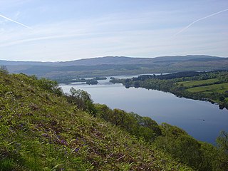
Loch Awe is a large body of freshwater in Argyll and Bute, Scottish Highlands. It has also given its name to a village on its banks, variously known as Loch Awe or Lochawe. There are islands within the loch such as Innis Chonnell and Inishail.

Lairg is a village and parish in Sutherland, Scotland. It has a population of 891 and is at the south-eastern end of Loch Shin.

The Kyle of Lochalsh line is a primarily single-track railway line in the Scottish Highlands, from Dingwall to Kyle of Lochalsh. Many of the passengers are tourists, but there are also locals visiting Inverness for shopping, and commuters. All services are provided by ScotRail and run beyond Dingwall to Inverness. In the past there were some through services to and from Glasgow, Edinburgh or Aberdeen. None of the line is electrified, and all trains on the line are diesel-powered, as are all other trains in the Scottish Highlands.
Lochinver is a village that is located at the head of the sea loch Loch Inver, on the coast in the Assynt district of Sutherland, Highland, Scotland. A few miles north-east is Loch Assynt which is the source of the River Inver which flows into Loch Inver at the village. There are 200 or so lochans in the area which makes the place very popular with anglers. Lochinver is dominated by the "sugar loaf" shape of Caisteal Liath, the summit peak of nearby Suilven.

The River Shin is a river in the Scottish North West Highlands.

Clachaig; is a small settlement, on the Cowal peninsula in Argyll and Bute, Scotland. It is located on the B836 road between the Holy Loch and Loch Striven, the hamlet is just over a mile long. Clachaig is a Gaelic word meaning 'stone place'.

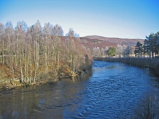
The River Conon is a river in the Highlands of Scotland. It begins at Loch Luichart, and flows in a south-easterly direction to be joined by the River Meig at Scatwell before passing through Loch Achonachie. It is joined by the Black Water at Moy Bridge, and the River Orrin at Urray, before flowing past Conon Bridge and into the Cromarty Firth.
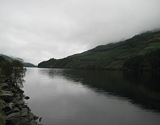
Loch Eck is a freshwater loch located on the Cowal peninsula, north of Dunoon, Argyll and Bute, Scotland. It is seven miles long. It is oriented in a north-south direction. Its main inflow, at the northern end, is the River Cur, and its main outflow, at the southern end, is the River Eachaig, which meanders somewhat within the confines of the broad strath before flowing into the head of Holy Loch, about 5 km further south.

Loch Ness is a large freshwater loch in the Scottish Highlands extending for approximately 37 kilometres southwest of Inverness. It takes its name from the River Ness, which flows from the northern end. Loch Ness is best known for claimed sightings of the cryptozoological Loch Ness Monster, also known affectionately as "Nessie". It is one of a series of interconnected, murky bodies of water in Scotland; its water visibility is exceptionally low due to the high peat content of the surrounding soil. The southern end connects to Loch Oich by the River Oich and a section of the Caledonian Canal. The northern end connects to Loch Dochfour via the River Ness, which then ultimately leads to the North Sea via the Moray Firth.

Elphin is a crofting township in Assynt, in the Sutherland area of Highland in Scotland. It lies about 15 miles north of Ullapool. The village contains a telephone box, a post box, a tearoom, a Scottish Mountaineering Club Hut, Grampian Speleological Group Hut, a small caravan site and many self-catering options. Assynt Primary School closed in 2001, and the building is now a community hall operated by Elphin Ledmore and Knockan Community Association Limited. The township now has its own website, see external links.
Badcall comprises two remote hamlets, called Lower Badcall and Upper Badcall. Upper Badcall, a crofting township, is the larger of the two and is situated on the western shore of Badcall Bay. Lower Badcall is located less than 1 mile to the east on the eastern shore of Badcall Bay. Badcall is on the west coast of Sutherland, Scottish Highlands and is in the Scottish council area of Highland.

Gruinard Bay is a large remote coastal embayment, located 12 miles north of Poolewe, in northwestern Ross and Cromarty, and is in the former parish of Lochbroom, in the west coast of Scotland.
The River Moriston is a river in Inverness-shire, Scotland. It flows broadly east-north-east from the outfall of the dam at Loch Cluanie to Loch Ness. Its waters and those of its tributaries have been harnessed to generate hydro-electric power.
Loch Dionard is a medium-sized loch in the Durness Parish, in Sutherland, Highland Council Area, Northern Scotland. It is in the North-Western Highlands about four miles south of Polla.
Loch Merkland is a large long inland loch in Sutherland, Northern Scotland. It is located adjacent to the A838 main road which provides almost all access to the Loch and the Merkland Lodge to the south of it. There are many trails and hiking paths in the area, as per usual in the highlands of Scotland. On the Banks just above the Lodge there's also Merkland Cottage meaning there are residents around the Loch.

Loch Borralan is a freshwater loch in the Assynt District of Sutherland in the Highland Council Area, northern Scotland.

Loch Hope is a loch in the Durness parish in Sutherland in the Highland Council Area of northern Scotland. It is located on the A838 main road. The settlements of Hope, Lochside, and Muiseal directly on the loch in addition nearby there's Inverhope, Heilam, Moine House, Alltnacaillich, Strathmore, ect.. The Loch is a large tourist destination for the area around it.

Cam Loch is an irregularly-shaped freshwater loch, about 5 km long, on a north-west to south-east orientation, located slightly north of the village of Elphin, in the Assynt district of Sutherland, Scotland. The loch is located in an area along with neighbouring Coigach, as the Assynt-Coigach National Scenic Area, one of 40 such areas in Scotland.

Loch an Doire Dhuibh is a small irregular shaped freshwater loch, situated on a north-east to south-west orientation in northern Wester Ross and located 7.5 miles southeast of Lochinver, Scotland. Directly to the northwest of the loch is Loch Gainmheich, considered the "northern portion" of the loch, by the editors of Bathymetrical Survey that is connected by a narrow channel with water flowing out of Doire Dhuibh and northwest to Loch Sionascaig. Loch an Doire Dhuibh is part of the Assynt - Coigach National Scenic Area.

Loch Lurgainn is a large remote and deep freshwater loch with a crescent shape with its concave side turned to the south. It is located in the Coigach peninsula in Lochbroom, Wester Ross. Loch Lurgainn is located 8 miles north of Ullapool and two miles south of Loch Sionascaig and is 3.5 miles southeast of Enard Bay. The scenic qualities of Coigach, along with neighbouring Assynt, have led to the area being designated as the Assynt-Coigach National Scenic Area, one of 40 such areas in Scotland. The main settlement in the area, located directly to the north-west is Achiltibuie.

