Buiston Loch, also known as Buston, Biston, and Mid Buiston was situated in the mid-Ayrshire clayland at an altitude of 90 m OD. The loch was natural, sitting in a hollow created by glaciation. The loch waters drained via the Garrier Burn that joins the Bracken and Lochridge Burns before joining the River Irvine.

Loch Brown, also known in Scots as Loch Broun, Broon or Broom, was situated in a kettle hole in the mid-Ayrshire clayland near Crosshands. It is nowadays (2011) visible as a surface depression in pastureland, partially flooded, situated in a low-lying area close to farms and dwellings of Skeoch, Dalsangan, Ladebrae, Lochhill, and Crosshands, mainly in the Parish of Mauchline and partly in Craigie, East Ayrshire, Scotland. Duveloch is an old name for the loch and this may derive from the Gaelic Dubh, meaning black or dark loch.
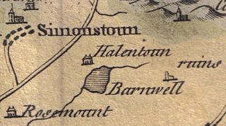
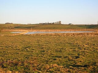
Helenton Loch was situated in a low lying area between the farms and dwellings of Helentongate, Mains, and Burnbank in the Parish of Symington, South Ayrshire, Scotland. The loch was natural, sitting in a hollow, a kettle hole, created by glaciation. The loch waters ultimately drained via the Pow Burn. Helenton Hill is a prominent landmark to the west of the old loch site. The nearby lands of Rosemount were in 1549 known as 'Goldring' and were the property of the Schaws of Sornbeg.

The Blae Loch is a small freshwater loch situated in a hollow in a low-lying area beneath Blaelochhead Hill in the Parish of Beith, North Ayrshire, Scotland.

The Galrigs Loch was a substantial freshwater loch situated in low lying area between Newfield and Dundonald in South Ayrshire, Scotland. It was drained in the early 18th century.

Clevens Loch was a substantial freshwater loch situated in a low-lying area below Clevance Farm and Langholm Farm in Dundonald parish, South Ayrshire, Scotland.

The Loch of Trabboch or Dalrympleston Loch (NS440211) was situated in a low-lying area below the old Castle of Trabboch, once held by the Boyd family in the Parish of Stair, East Ayrshire, Scotland.
The Loch of Stair was a typical Ayrshire post-glacial 'Kettle Hole', situated in a low-lying area below the farm of Loch Hill, in the Parish of Stair, East Ayrshire, Scotland. This freshwater loch was drained in the 19th century, leaving a wetland area which still periodically floods.

Carcluie Loch is a small freshwater loch in the South Ayrshire Council Area, lying in a glacial Kettle Hole, Parish of Dalrymple, Scotland.

Auchencloigh Castle or Auchincloigh Castle is a ruined fortification near the Burnton Burn, lying within the feudal lands of the Craufurd Clan, situated in the Parish of Ochiltree, East Ayrshire, Scotland.
Plaid Loch was a freshwater loch in East Ayrshire, now a remnant due to drainage, near Sinclairston and 2 miles (3 km) south-east of Drongan, lying in a glacial kettle hole,.

Whitehill Loch, previously known as Hillhouse Loch was a freshwater loch in the East Ayrshire Council Area, now drained, near Galston, in the Parish of Riccarton, lying in a glacial Kettle Hole.

Bruntwood Loch was a freshwater loch, now drained, lying in a glacial kettle hole in Galston, East Ayrshire, Scotland.

Black Loch is a freshwater loch, named from its dark waters, situated in the East Ayrshire Council Area, between Cumnock and New Cumnock, lying in a glacial Kettle Hole mainly within the Parish of New Cumnock, a small portion protruding into Old Cumnock Parish. It is said to be one of only two lochs or lakes in the world that have outflows running to two separate destinations. The 'Runner' is a deep and broad ditch that was dug many years back to link the three lochs of Lowes, Black, and Creoch.

Creoch Loch, previously known as Little Creoch Loch, is a freshwater loch in the Parish of New Cumnock in the East Ayrshire Council Area between Cumnock and New Cumnock, Scotland. It is located in a glacial kettle hole and is one of three linked lochs.

Loch o' th' Lowes, Lochside or Meikle Creoch Loch is a freshwater loch in the Parish of New Cumnock in the East Ayrshire Council Area, Scotland. One of three linked lochs, it is overlooked by the A76 road and is located in a glacial kettle hole.
Loans is a village in South Ayrshire near Troon, Scotland. It is located in Dundonald parish on the A759 at the junction with the B746 and a minor road to Dundonald.

Newton Loch was situated in a low-lying area near Newton-on-Ayr, South Ayrshire, just south of the old South and West Sanquhar Farms. It is now (2016) only visible as remnant heath land and surface darkening in pastureland, situated mainly in the Parish of Ayr and partly in St Quivox, South Ayrshire, Scotland.

The Lands of Borland or Boreland formed a castle and land holdings within the old Barony of Cumnock, East Ayrshire, Parish of Old Cumnock, Scotland. Lying two miles south of Cumnock the property was mainly held by a cadet branch of the Hamilton family from around 1400 before passing by marriage to the Montgomeries and others. For consistency the spelling 'Borland' will be used throughout.
What now survives of the old Caprington Loch (NS402352) is situated near Earlston, Riccarton, East Ayrshire, Scotland. The loch was a natural feature, sitting in a hollow on the old Caprington Castle estate. The loch waters drain via the Todrigs Burn that flows into the River Irvine to the east of Gatehead village. It was partly drained, probably sometime after the 1820s, as were so many other lochs, as part of 18th and 19th centuries extensive agricultural improvements and the only area of open water that remains does so as it was once used as a curling pond for the Caprington Castle Estate owners and their employees or tenants.

