Logan County is a county in the U.S. state of West Virginia. As of the 2010 census, the population was 36,743. Its county seat is Logan. Logan County comprises the Logan, WV Micropolitan Statistical Area, which is also included in the Charleston–Huntington–Ashland, WV–OH–KY Combined Statistical Area.

Chapmanville is a town in Logan County, West Virginia, in the United States. The population was 1,256 at the 2010 census. Chapmanville, originally called Chapmansville, is named for Ned Chapman, an early settler who operated a store and post office. It was incorporated in 1947.

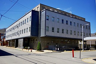
Logan is a city in Logan County, West Virginia, United States, along the Guyandotte River. The population was 1,779 at the 2010 census. It is the county seat of Logan County.

Mitchell Heights is a town in Logan County, West Virginia, United States. The population was 323 at the 2010 census. The town was named for an early farm on which it was established.

Mount Gay-Shamrock is a census-designated place (CDP) in Logan County, West Virginia, United States. The population was 1,779 at the 2010 census. The CDP includes the unincorporated communities of Mount Gay, Shamrock, Black Bottom, Whites Addition, Lintz Addition, Thompson Town, Hedgeview, Ridgeview, Logan Heights, Cora, and Whitman Junction.

West Logan is a town along the Guyandotte River in Logan County, West Virginia, United States. The population was 424 at the 2010 census. For unknown reasons, some sources report West Logan to lay west of the county seat at Logan, attributing to this fact the name.

Logan Heights is an urban neighborhood in central San Diego, California. It is bordered by Interstate 5 on the south and west, Interstate 15 on the east, and Imperial Avenue on the north. It is part of the Southeastern Planning Area.
Logan Heights may refer to:

Chief Logan State Park is located on 3,988 acres (1,614 ha) about 4 miles (6.4 km) north of Logan in Logan County, West Virginia, United States. The park, the town and the county were all named after Chief Logan, a Mingo Native American leader who lived in the region before the American Revolutionary War. Each summer the Liz Spurlock Amphitheater at Chief Logan State Park is the site for outdoor dramas, including the historical drama "The Aracoma Story" about Shawnee tribal members who lived at the present-day location of the town of Logan. The outdoor drama theater produces the Aracoma story and 2-3 other plays or musicals every year.

This is a list of the National Register of Historic Places listings in Logan County, West Virginia.

Lake is an unincorporated community in Logan County, West Virginia, United States. Lake is 4.5 miles (7.2 km) east-northeast of Mitchell Heights. Lake has a post office with ZIP code 25121.
Pecks Mill is an unincorporated community in Logan County, West Virginia, United States. Pecks Mill is located on the Guyandotte River and West Virginia Route 10 1.5 miles (2.4 km) north of Mitchell Heights. Pecks Mill has a post office with ZIP code 25547.
Henlawson is a census-designated place (CDP) in Logan County, West Virginia, United States. Henlawson has a post office with ZIP code 25624. As of the 2010 census, its population was 442. Henlawson is believed to have been named after a resident, Henry Lawson. Merrill Coal Mines opened Merrill Mines here in 1921 and built homes to house the miners.
Barnabus is an unincorporated community in Logan County, West Virginia, United States, along West Virginia Route 44 and Island Creek. Barnabus is 7.5 miles (12.1 km) south of Logan. Barnabus was named for one of its founding citizens, Barnabus Curry b. 1789 d. 1869.
Monitor is an unincorporated community in Logan County, West Virginia, United States. Monitor is located along Island Creek and West Virginia Route 44 1.2 miles (1.9 km) south-southwest of Logan.
Black Bottom is an unincorporated community in Logan County, West Virginia, United States. Black Bottom is located along West Virginia Route 73 0.6 miles (0.97 km) west of Logan. It is part of the Mount Gay-Shamrock census-designated place.
Sodom is an unincorporated community in Logan County, West Virginia.

Godby Heights is an unincorporated community in Logan County, West Virginia.


