Related Research Articles

Caswell Beach is a small seaside town located on the Atlantic Ocean at the mouth of the Cape Fear River in Southeastern North Carolina. Occupying the eastern part of Oak Island in Brunswick County, its population was listed at 398 in the 2010 census. Prominent features include the Civil War era Fort Caswell, the Oak Island Lighthouse co-located with the Oak Island Coast Guard Station, and the Oak Island Golf Club, the sole business in town and one of the few eighteen-hole courses located on a North Carolina barrier island. Along with the Town of Oak Island which occupies the central and west parts of the island, Caswell Beach is considered to be in the Myrtle Beach metropolitan area.

Holden Beach is a seaside town in Brunswick County, North Carolina, United States. The population was 575 at the 2010 census. It is part of the Myrtle Beach metropolitan area.
Oak Island is a seaside town located in the southeastern corner of North Carolina. Part of Brunswick County, the major portion of the town is on Oak Island which it shares with Caswell Beach. Founded in 1999 as the result of the consolidation of two existing towns, Oak Island's main industry is tourism. Per the 2010 census, it had a permanent population of 6,783 which in 2019 was estimated to be 8,386. Its average summer population ranges from 30-50,000 and the town is considered to be a part of the Myrtle Beach metropolitan area.

Ocean Isle Beach is a small seaside town located in Brunswick County, North Carolina, United States. The population was 550 at the 2010 census. It was incorporated as a town in 1959, and is part of the Myrtle Beach metropolitan area.

Wrightsville Beach is a town in New Hanover County, North Carolina, United States. Wrightsville Beach is just east of Wilmington and is part of the Wilmington Metropolitan Statistical Area. The population was 2,477 at the 2010 census. The town consists of a 4-mile (6 km) long beach island, an interior island called Harbor Island, and pockets of commercial property on the mainland. It served as a filming location of Dawson's Creek.

Briarcliffe Acres is a town in Horry County, South Carolina, United States, located between Myrtle Beach and North Myrtle Beach. The population was 457 at the 2010 census.

Westerly is a town on the southwestern shoreline of Washington County, Rhode Island, first settled by English colonists in 1661 and incorporated as a municipality in 1669. It is a beachfront community on the south shore of the state with a population of 23,359 as of the 2020 census.
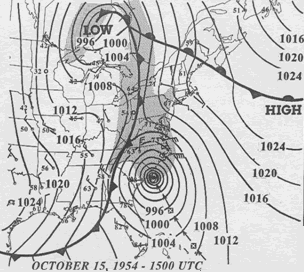
Hurricane Hazel was the deadliest, second costliest, and most intense hurricane of the 1954 Atlantic hurricane season. The storm killed at least 469 people in Haiti before striking the United States near the border between North and South Carolina as a Category 4 hurricane. After causing 95 fatalities in the US, Hazel struck Canada as an extratropical storm, raising the death toll by 81 people, mostly in Toronto. As a result of the high death toll and the damage caused by Hazel, its name was retired from use for North Atlantic hurricanes.

Oakwood is a neighborhood located in east central Staten Island, New York City, near the South Shore. It is bordered by Tysens Lane (north); the Atlantic Ocean (east); Great Kills Park (south); Kensico Street, and Clarke Avenue (west).
Yaupon Beach, North Carolina is a neighbourhood of the coastal town of Oak Island in Brunswick County, North Carolina.
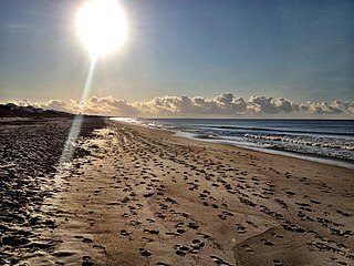
Oak Island is located on the Atlantic Ocean coast in Brunswick County, North Carolina near the South Carolina border. A barrier island, it contains the towns of Oak Island and Caswell Beach, Fort Caswell and the Oak Island Coast Guard Station which is co-located with the Oak Island Lighthouse. Almost 13 miles long, the island averages about one mile wide. Approximately 7000 people live on it year-round, a number which can balloon to over 40,000 during the summer

San Pedro Bay is an inlet on the Pacific Ocean coast of southern California, United States. It is the site of the Port of Los Angeles and the Port of Long Beach, which together form the fifth-busiest port facility in the world and the busiest in the Americas. The Los Angeles community of San Pedro borders a small portion of the western side of the bay, and shares the name. The city of Long Beach borders the port on the eastern side of the bay. The northern part of the bay, which is the largest part of the port, is bordered by the Los Angeles neighborhood of Wilmington.

Hurricane Ophelia was the fifteenth named tropical cyclone and the eighth hurricane of the 2005 Atlantic hurricane season. It was a long-lived storm that was most memorable for its very erratic and extremely slow track off the East Coast of the United States, alternating several times between tropical storm and hurricane intensity.

Hog Island was the name of two islands near Long Island, New York until the 1890s. One is the present day Barnum Island, which includes the villages of Island Park and Harbor Isle in Nassau County. The other was a mile-long (1600 m) barrier island that existed to the south of Rockaway Beach in Queens before being mostly destroyed by the 1893 New York hurricane and completely lost to erosion and storm damage by 1902.
Bird Island is approximately 1,300 acres (5.3 km2) adjacent to the town of Sunset Beach, North Carolina, USA. Sunset Beach is on a barrier island and is the southernmost town in North Carolina. Bird Island can be reached by walking along the seashore toward the South Carolina border. Due to the contour of the Atlantic Coast at this point, the direction of travel to Bird Island is approximately West-Southwest. Previously, Bird Island was separated from Sunset Beach by a tidal creek that could be easily crossed only at low tide. Accretion of ocean sand has gradually filled in the tidal creek so that two separate islands became one.

The 1949 Florida hurricane, also known as the Delray Beach hurricane, caused significant damage in the southern portions of the state late in the month of August. The second recorded tropical cyclone of the annual hurricane season, the system originated from a tropical wave near the northern Leeward Islands on August 23. Already a tropical storm upon initial observations, the cyclone curved west-northwestward and intensified, becoming a hurricane on August 25. Rapid intensification ensued as the storm approached the central Bahamas early on August 26, with the storm reaching Category 4 hurricane strength later that day and peaking with maximum sustained winds of 130 mph (215 km/h) shortly after striking Andros. Late on August 26, the storm made landfall near Lake Worth, Florida, at the same intensity. The cyclone initially weakened quickly after moving inland, falling to Category 1 status early the next day. Shortly thereafter, the system curved northward over the Nature Coast and entered Georgia on August 28, where it weakened to a tropical storm. The storm then accelerated northeastward and became extratropical over New England by August 29. The remnants traversed Atlantic Canada and much of the Atlantic Ocean before dissipating near Ireland on September 1.

The 2015 Atlantic hurricane season was an event in the annual hurricane season in the north Atlantic Ocean. It was the third consecutive year to feature below-average tropical cyclone activity, with eleven named storms. The season officially began on June 1, 2015 and ended on November 30, 2015. These dates, adopted by convention, historically describe the period in each year when most tropical systems form. However, systems can and do form outside these dates, as did the season's first storm, Tropical Storm Ana, which developed on May 8; the season's final storm, Hurricane Kate, lost its tropical characteristics on November 11.

The 2016 Atlantic hurricane season was an event in the annual tropical cyclone season in the north Atlantic Ocean. It was the costliest, as well as the first above-average, Atlantic hurricane season since the 2012 season. It featured the highest number of deaths since the 2008 season and also yielded the highest number of named storm landfalls on the United States since that year. The season officially began on June 1 and concluded on November 30, dates which conventionally delimit the period during each year when a majority of tropical cyclones form in the Atlantic Ocean. The season's first cyclone, Alex, developed on January 12, while the final storm of the season, Otto, closed-out the season by exiting into the Eastern Pacific on November 25, becoming the first Atlantic–Pacific crossover hurricane since Hurricane Cesar–Douglas in 1996.
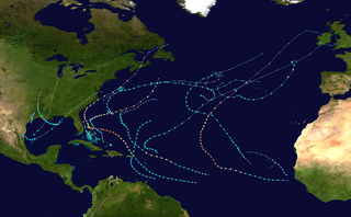
The 2019 Atlantic hurricane season was an event in the annual tropical cyclone season in the north Atlantic Ocean. It was the fourth consecutive above-normal Atlantic hurricane season. The season officially began on June 1, 2019 and ended on November 30, 2019. These dates, adopted by convention, historically describe the period in each year when most tropical systems form. However, storm formation is possible at any time of the year, as demonstrated in 2019 by the formation of the season's first named storm, Subtropical Storm Andrea, on May 20. The final storm of the season, Tropical Storm Sebastien, transitioned to an extratropical cyclone on November 25.

The 2020 Atlantic hurricane season was the most active Atlantic hurricane season on record in terms of number of named storms. Additionally, it was as an above-average season for tropical cyclones for the fifth consecutive year. The season officially began on June 1, 2020, and ended on November 30, 2020. These dates, adopted by convention, historically delimit the period each year when most Atlantic tropical systems form. However, storm formation is possible at any time of the year, as was the case this season, when its first two named storms, Tropical Storm Arthur and Tropical Storm Bertha, formed on May 16 and May 27, respectively. The final storm, Hurricane Iota, dissipated on November 18.
References
- ↑ Gifford, Jim (2004). Hurricane Hazel: Canada's Storm of the Century. Toronto: Dundurn Press. p. 22. ISBN 1-55002-526-0.
- ↑ "Long Beach". Star-News. May 24, 1998. p. 36. Retrieved 1 November 2015.
| General | |
|---|---|
| National libraries | |
Coordinates: 33°54′38″N78°07′04″W / 33.91056°N 78.11778°W