Related Research Articles

Brunswick County is the southernmost county in the U.S. state of North Carolina. As of the 2020 census, the population was 136,693. Its population was only 73,143 in 2000, making it one of the fastest-growing counties in the state. With a nominal growth rate of approximately 47% in ten years, much of the growth is centered in the eastern section of the county in the suburbs of Wilmington such as Leland, Belville and Southport. A 2019 estimated population of 142,820 makes Brunswick the fourth-fastest-growing county in the country. The county seat is Bolivia, which at a population of around 150 people is among the least populous county seats in the state.

Boiling Spring Lakes is a city in Brunswick County, North Carolina, United States. The population was 5,943 at the 2020 census, up from 5,372 in 2010.
Calabash is a small fishing town in Brunswick County, North Carolina, United States. The population was 1,786 at the 2010 census, up from 711 in 2000. It prides itself on being known as the "Seafood Capital of the World" because of the town's "Calabash-Style" seafood restaurants.

Caswell Beach is a small seaside town located on the Atlantic Ocean at the mouth of the Cape Fear River in Southeastern North Carolina, United States. Occupying the eastern part of Oak Island in Brunswick County, its population was listed at 398 in the 2010 census. Prominent features include the Civil War era Fort Caswell, the Oak Island Lighthouse co-located with the Oak Island Coast Guard Station, and the Oak Island Golf Club, the sole business in town and one of the few eighteen-hole courses located on a North Carolina barrier island. Along with the Town of Oak Island which occupies the central and west parts of the island, Caswell Beach is considered to be in the Myrtle Beach metropolitan area.

Holden Beach is a seaside town in Brunswick County, North Carolina. The population was 575 at the time of the 2010 census. It is part of the Myrtle Beach metropolitan area.
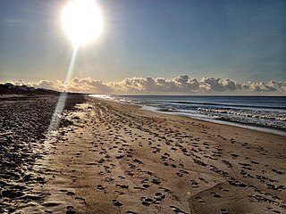
Oak Island is a seaside town located in the southeastern corner of North Carolina, United States. Part of Brunswick County, the major portion of the town is on Oak Island which it shares with Caswell Beach. Founded in 1999 as the result of the consolidation of two existing towns, Oak Island's main industry is tourism. Per the 2010 census, it had a permanent population of 6,783, which in 2019 was estimated to be 8,386. Its average summer population ranges from 30 to 50,000 and the town is considered to be a part of the Myrtle Beach metropolitan area.

Ocean Isle Beach is a small seaside town located in Brunswick County, North Carolina, United States. The population was 550 at the 2010 census. It was incorporated as a town in 1959 and is part of the Myrtle Beach metropolitan area.
Shallotteshə-LOHT is a town in Brunswick County, North Carolina, United States. The population was 3,675 at the 2010 census. The Shallotte River passes through the town.

Sunset Beach is a seaside town in Brunswick County, North Carolina, United States. The population was 3,572 at the 2010 census, up from 1,824 in 2000. It is part of the Myrtle Beach metropolitan area.
Chadbourn is a town in Columbus County, North Carolina, United States. The population was 1,856 at the 2010 census.

Wrightsville Beach is a town in New Hanover County, North Carolina, United States. Wrightsville Beach is just east of Wilmington and is part of the Wilmington Metropolitan Statistical Area. The population was 2,477 at the 2010 census. The town consists of a 4-mile (6 km) long beach island, an interior island called Harbor Island, and pockets of commercial property on the mainland. It served as a filming location of Dawson's Creek.
Long Beach, North Carolina is a coastal neighborhood on Oak Island incorporated in 1955. It is well known for the total devastation it sustained during Hurricane Hazel in 1954; only five of the 357 buildings survived the storm. It merged with neighboring Yaupon Beach in 1999 to form the town of Oak Island and is now a neighborhood of the town.
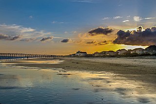
Oak Island is located on the Atlantic Ocean coast in Brunswick County, North Carolina near the South Carolina border. A barrier island, it contains the towns of Oak Island and Caswell Beach, Fort Caswell and the Oak Island Coast Guard Station which is co-located with the Oak Island Lighthouse. Almost 13 miles long, the island averages about one mile wide. Approximately 7000 people live on it year-round, a number which can balloon to over 40,000 during the summer
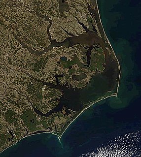
The Outer Banks are a 200 mi (320 km) string of barrier islands and spits off the coast of North Carolina and southeastern Virginia, on the east coast of the United States. They line most of the North Carolina coastline, separating Currituck Sound, Albemarle Sound, and Pamlico Sound from the Atlantic Ocean. A major tourist destination, the Outer Banks are known for their wide expanse of open beachfront and the Cape Hatteras National Seashore. The seashore and surrounding ecosystem are important biodiversity zones, including beach grasses and shrubland that help maintain the form of the land.
Bird Island is approximately 1,300 acres (5.3 km2) adjacent to the town of Sunset Beach, North Carolina, USA. Sunset Beach is on a barrier island and is the southernmost town in North Carolina. Bird Island can be reached by walking along the seashore toward the South Carolina border. Due to the contour of the Atlantic Coast at this point, the direction of travel to Bird Island is approximately West-Southwest. Previously, Bird Island was separated from Sunset Beach by a tidal creek that could be easily crossed only at low tide. Accretion of ocean sand has gradually filled in the tidal creek so that two separate islands became one.

Cape Fear is a coastal plain and Tidewater region of North Carolina centered about the city of Wilmington. The region takes its name from the adjacent Cape Fear headland, as does the Cape Fear River which flows through the region and empties into the Atlantic Ocean near the cape. Much of the region's populated areas are found along the Atlantic beaches and the Atlantic Intracoastal Waterway, while the rural areas are dominated by farms and swampland like that of the Green Swamp. The general area can be also identified by the titles "Lower Cape Fear", "Wilmington Metropolitan Area", "Southeastern North Carolina", and "Azalea Coast". The latter name is derived from the North Carolina Azalea Festival held annually in Wilmington. Municipalities in the area belong to the Cape Fear Council of Governments.
Smithville Township is one of six townships within Brunswick County, North Carolina, United States. As of the 2000 Census, Smithville Township had a population of 12,019 and a population density of 152 inhabitants per square mile (59/km2). It is a part of the Myrtle Beach metropolitan area.
The Shallotte River is a tidal river in Brunswick County, North Carolina, United States. Waters drain from the tributaries of the Green Swamp near the town of Shallotte and flow south down the river to empty into the Atlantic Intracoastal Waterway.

Bay Island is a small island located halfway down Balboa Peninsula in Newport Beach, California. It is the only island in the Newport Beach harbor islands that does not allow car traffic. The island is accessible via a small bridge that will only accommodate golf carts. The island is not accessible to the public. It has 23 residences, a botanical garden, courtyard garden, tennis court, and several beaches.
North Carolina Highway 133 (NC 133) is a primary state highway in the U.S. state of North Carolina. It traverses 46.6 miles (75.0 km) from Oak Island Drive in Oak Island to NC 210 in Bells Crossroads. The route serves communities such as Southport, Belville, Leland, Wilmington, and Castle Hayne. Additionally, NC 133 serves as an entry point for Military Ocean Terminal Sunny Point located to its east. Much of NC 133 runs parallel to the Cape Fear River and Brunswick River between Southport and Belville. West of Wilmington, NC 133 runs concurrently with U.S. Route 17 (US 17), US 74, and US 76. The road follows another concurrency along US 74 and US 421, west of Downtown Wilmington, and crosses into New Hanover County on the Isabel Holmes Bridge. North of Wilmington, NC 133 exits to the north, serving several suburban communities north of Wilmington. NC 133 runs concurrently with US 117 through Castle Hayne, before bearing northwest toward Bells Crossroads.
References
- ↑ "Yaupon Beach". Star-News. May 24, 1998. p. 34. Retrieved 1 November 2015.
- ↑ Proffitt, Martie (Apr 17, 1983). "Local history offers tasty tidbits". Star-News. pp. 1C. Retrieved 1 November 2015.
Coordinates: 33°54′18″N78°04′42″W / 33.90500°N 78.07833°W
| General | |
|---|---|
| National libraries | |