Long Beach Oil Field

Last updated
Location of the Long Beach Oil Field in the context of the Los Angeles Basin and Southern California. Other oil fields are shown in dark gray. LongBeachOF.jpg
Location of the Long Beach Oil Field in the context of the Los Angeles Basin and Southern California. Other oil fields are shown in dark gray.

The Long Beach Oil Field is a large oil field underneath the cities of Long Beach and Signal Hill, California, in the United States. Discovered in 1921, the field was enormously productive in the 1920s, with hundreds of oil derricks covering Signal Hill and adjacent parts of Long Beach; largely due to the huge output of this field, the Los Angeles Basin produced one-fifth of the nation's oil supply during the early 1920s. In 1923 alone the field produced over 68 million barrels of oil, and in barrels produced by surface area, the field was the world's richest. [1] [2] [3] The field is eighth-largest by cumulative production in California, and although now largely depleted, still officially retains around 5 million barrels of recoverable oil out of its original 950 million. 294 wells remained in operation as of the beginning of 2008, and in 2008 the field reported production of over 1.5 million barrels of oil. [4] The field is currently run entirely by small independent oil companies, with the largest operator in 2009 being Signal Hill Petroleum, Inc. [5] [6]

Contents

Setting

Detail of the Long Beach field, on an aerial photograph base, showing its position within Long Beach and surrounding communities. LBDetail.jpg
Detail of the Long Beach field, on an aerial photograph base, showing its position within Long Beach and surrounding communities.
Signal Hill oil field in 1926 Signal Hill, 1926.jpg
Signal Hill oil field in 1926
Signal Hill oil field, c. 1941-1947 California - Long Beach - NARA - 23934465.jpg
Signal Hill oil field, c. 1941-1947

The Long Beach field is one of many in the Los Angeles Basin now largely overbuilt with dense urban development. Even with the dramatic land use changes over the decades since its discovery, it remains moderately productive, with oil wells and oilfield infrastructure intermixed with commercial and residential development. The field underlies the northern portion of the city of Long Beach and most of the city of Signal Hill. In spite of its name, most of the productive area of the field underlies the small city of Signal Hill, which has a population of around 11,000. The main productive area of the field runs from northwest to southeast, about five miles (8 km) long by one across, with the long axis following the Cherry Hill Fault Zone, which is part of the larger Newport–Inglewood Fault Zone, the most significant fault zone traversing the Los Angeles Basin. [7] In the northwest, the oil field begins approximately near the junction of the San Diego Freeway (I-405) and the 710 (the Long Beach Freeway), and proceeds roughly paralleling the 405 freeway to near the intersection of Lakewood Boulevard and California State Route 1 (the Pacific Coast Highway) at their traffic circle in Long Beach. A small portion of the field, no longer productive, is in the city of Lakewood, and another small isolated part of the field, the "Recreation Park Area", lies to the southeast of the main field. The total productive area of the entire field is 1,725 acres (6.98 km2). [8]

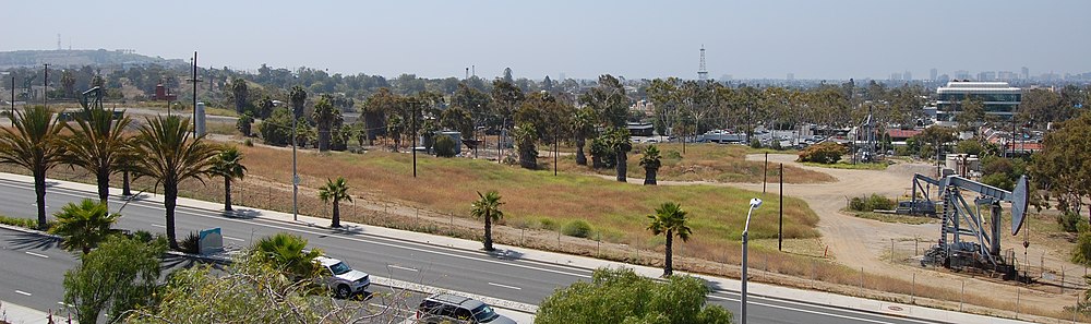
Unlike some of the oil fields in downtown Los Angeles, the adjacent Mid-City area, and Beverly Hills, which hide their oil wells inside soundproofed, windowless enclosures, attempting to be as invisible as possible, most of the wells in the Long Beach field use normal above-ground pumpjacks, sometimes behind walls or inside of fenced enclosures, but also scattered through the community in parking lots, in freeway cloverleaf medians, vacant lots, and other empty spaces. [7] Typically, residential structures are not immediately adjacent to wells. Also differentiating this field from the completely urbanized oil fields nearer to downtown, most wells are drilled vertically rather than directionally from drilling enclosures.

Climate in the area is Mediterranean, with cool rainy winters and mild summers, with the heat moderated by morning fog and low clouds. Drainage is by municipal storm drains into the Los Angeles River to the west, and the San Gabriel River to the east, both of which flow south into San Pedro Bay in the Pacific Ocean. As the area is largely urbanized, few areas of native vegetation and wildlife habitat remain.

Geology

Long Beach Oil Field Structure Map LongBeachOilFieldStructureMap.jpg
Long Beach Oil Field Structure Map

The Long Beach field is one of many prolific oil fields along the Newport–Inglewood Fault zone, which includes the enormous Huntington Beach Oil Field on the south, the Seal Beach Oil Field, the Long Beach field, and to the northwest of that the Dominguez, Rosecrans, and Inglewood fields.

The main portion of the Long Beach field is an anticlinal structure paralleling the fault zone, with Signal Hill being its surface expression. Oil, which rises to the surface unless something is in the way, is trapped underneath impermeable units, in a series of oil bearing formations alternating with impermeable ones, like layers on a cake, but folded to form a long, narrow hill. The Long Beach field is notable for the thickness and depth of its oil-bearing formations; successively deeper wells continued to find oil even as late as the 1950s, with the deepest well finally hitting the basement rocks of the Catalina Schist at 14,950 feet (4,560 m) below ground surface. [7] [9]

Within the main area of the Long Beach field, seven separate pools have been defined, ranging in depth from around 2,000 feet (610 m) to over 7,500 feet (2,300 m). The thickness of the oil-bearing units was extraordinary, and largely accounted for the field's unusual standing as being the richest field by oil extracted per acre in the world, at least in the 1920s and 1930s. [10] [11] Primary productive geologic units in the field are the Pliocene-age Repetto Formation and the Miocene Puente Formation. Both of these porous units are richly oil-bearing elsewhere in the Los Angeles Basin as well, anywhere that oil can collect due to a combination of stratigraphic and structural traps.

Oil from the Long Beach field tends to be medium- to heavy-grade, with API gravity ranging from 14 to 30, and sulfur content relatively high at 2 to 3 percent by weight. [12]

History, production, and operations

Signal Hill California 1923.jpg
Signal Hill c1923

Oil was known in the Los Angeles basin since prehistoric times, as the La Brea Tar Pits are a surface expression of the Salt Lake Oil Field; crude oil seeps to the surface along a fault, biodegrading to asphalt. The native inhabitants of the region used the tar for many purposes, including as a sealant, and the first European settlers found similar uses. In the mid-19th century, oil had become a valuable commodity as an energy source, commencing a period of exploration and discovery for the sources of the substance. By the 1890s, prospectors were drilling for oil in the basin, and in 1893 the first large field – the Los Angeles City Oil Field, adjacent and underneath the then-small city of Los Angeles – became the largest oil producer in the state. Oil companies began finding other rich fields not far away, such as the Beverly Hills and Salt Lake fields. Attention shifted to Kern County in the first two decades of the 20th century, as the super-giant fields there were discovered one at a time.

The Long Beach field was one of several significant oil discoveries in the Los Angeles basin and adjoining area in the 1920s, and by far the most productive. In 1920 drillers found the Huntington Beach field; in 1921 both the Santa Fe Springs field and the Long Beach field; and the others along the Newport–Inglewood Fault zone followed quickly after, with the Dominguez field in 1923, and the Inglewood and Rosecrans fields in 1924. [2] [13] When the discovery well was drilled, the Signal Hill area was already being developed with residences, as the hill offered a commanding view of the harbor area to the south. Initially, the Shell Oil geologists opposed drilling on the hill, as competitor Union Oil had tried and failed to find oil there just four years earlier, and they were unwilling to risk a repeat of the series of costly failures that had plagued them recently at the Ventura field. Yet the discovery well, Alamitos oil well No. 1 (now a historical landmark at the corner of East Hill Street and Temple Ave.) blew in as a tremendous gusher on June 25, 1921. [10] [14]

Signal Hill view in the 1930s, postcard Air View, Famous Signal Hill, Signal Hill, Calif.jpg
Signal Hill view in the 1930s, postcard

In the 1920s there were few regulations on well spacing, and Signal Hill sold narrow town lots which were quickly bought up by would-be oil millionaires, who put in wells that were virtually touching each other; in spite of this close spacing, most were profitable, although they drained the field quickly. Signal Hill became known as "Porcupine Hill" for its prickly appearance at a distance, covered with hundreds of wooden oil derricks (the low "nodding-donkey" pumpjack was yet to be invented). By 1923 the production from the field had become so abundant that oil from the Los Angeles Basin accounted for fully twenty percent of the entire world output. [15] 1923 was the peak year for production from the field, and that also coincided with the peak for production from the entire Los Angeles basin; in spite of large discoveries in the 1930s, including the nearby Wilmington field, fourth-largest in the nation, production never again attained that level. The price of oil had risen steeply, from $0.64/barrel in 1916 to $3.07 in 1920, largely because of the enormous increase in the number of automobiles on the roads – during that time the number of cars had tripled. [16]

Production slowed during the Great Depression, as the price of oil dropped with the demand, and the discovery of huge new fields not only in the Los Angeles Basin, but in Oklahoma and Texas, put a glut of petroleum on the market. [17]

By 1950 the field was third in the United States in overall output, with a cumulative production of 750 million barrels of oil. Ahead of it were only the giant East Texas and Midway-Sunset fields. [18] As production began to decline, and the technology became available, several waterflooding programs began, with the first in 1964 in the "Brown" horizon of the Repetto Formation. The goal was both to increase the flow of oil to production wells, and to replace the fluids pumped out of the reservoir in order to prevent subsidence, such as had occurred over the Wilmington field to the south. [19]

Long Beach Oil Field.jpg
Long Beach Oil Field in 2011.

In the 1980s and 1990s, Barto Enterprises, the ancestor of Signal Hill Petroleum, acquired many of the local assets of the large oil companies – ARCO, Unocal, Shell, Mobil, Texaco, and others – that had previously been major operators on the Long Beach field (most of the majors moved out of the Los Angeles Basin during that time, seeking easier opportunities elsewhere; most present-day operators are small to medium-sized independents). As of 2009, Signal Hill Petroleum operated more than 90% of the wells on the field, as well as several enhanced recovery projects, including the waterflooding program. [20]

See also

Notes

  1. Schmitt, R. J., Dugan, J. E., and M. R. Adamson. "Industrial Activity and Its Socioeconomic Impacts: Oil and Three Coastal California Counties." MMS OCS Study 2002-049. Coastal Research Center, Marine Science Institute, University of California, Santa Barbara, California. MMS Cooperative Agreement Number 14-35-01-00-CA-31603. 244 pages; p. 47.
  2. 1 2 "Oil and Gas Production: History in California" (PDF). California Department of Oil, Gas, and Geothermal Resources (DOGGR). California Department of Conservation. Archived from the original (PDF) on January 30, 2012. Retrieved December 7, 2009.
  3. Long Beach EIR, p. 4.4-6
  4. "2008 Preliminary Report of California Oil and Gas Production Statistics" (PDF). California Department of Conservation. January 2009. Retrieved December 7, 2009.
  5. "Oil and Gas Statistics: 2007 Annual Report" (PDF). California Department of Conservation. December 31, 2007. Archived from the original (PDF) on 2019-04-12. Retrieved August 25, 2009.
  6. California Department of Oil, Gas, and Geothermal Resources well and field query page
  7. 1 2 3 "Explorer".
  8. DOGGR, p. 244
  9. DOGGR, p. 242-248
  10. 1 2 "Oil history in California: The Paleontological Research Institution". Archived from the original on 2011-09-04. Retrieved 2009-12-13.
  11. Schmitt et al., p. 47
  12. DOGGR, p. 244-248
  13. DOGGR, p. 429, etc.
  14. Information on the Alamitos No. 1 well at "Lets Go See It.com"
  15. Schmitt, et al. p. 48
  16. Schmitt et al., p. 48-49
  17. Schmitt et al., p. 52
  18. Schmitt et al., pp. 47-48
  19. DOGGR, p. 246
  20. Signal Hill Petroleum web site

Related Research Articles

<span class="mw-page-title-main">Elk Hills Oil Field</span> Oil field in Kern County, California United States

The Elk Hills Oil Field is a large oil field in western Kern County, in the Elk Hills of the San Joaquin Valley, California in the United States, about 20 miles (32 km) west of Bakersfield. Discovered in 1911, and having a cumulative production of close to 1.3 billion barrels (210,000 dam3) of oil at the end of 2006, it is the fifth-largest oil field in California, and the seventh-most productive field in the United States.

<span class="mw-page-title-main">South Cuyama Oil Field</span>

The South Cuyama Oil Field is a large oil and gas field in the Cuyama Valley and the adjacent northern foothills of the Sierra Madre Mountains in northeastern Santa Barbara County, California. Discovered in 1949, and with a cumulative production of around 225 million barrels (35,800,000 m3) of oil, it ranks 27th in size in the state, but is believed to retain only approximately two percent of its original oil, according to the official estimates of the California Department of Oil, Gas, and Geothermal Resources (DOGGR). Of the top forty onshore oil fields in California, it is the most recent to be discovered, but by the end of 2008 only 87 wells remained in production.

<span class="mw-page-title-main">Fruitvale Oil Field</span> Oil and gas field in the San Joaquin Valley, California, USA

The Fruitvale Oil Field is a large oil and gas field in the southern San Joaquin Valley, California, within and just northwest of the city of Bakersfield, along and north of the Kern River. It is one of the few oil fields in the California Central Valley which is mostly surrounded by a heavily populated area. Discovered in 1928, and with a cumulative total recovery of more than 124 million barrels (19,700,000 m3) of oil at the end of 2006, it is 41st in size among California oil fields, and according to the California Department of Oil, Gas, and Geothermal Resources (DOGGR) its total reserve amounts to a little less than ten percent of its original oil.

<span class="mw-page-title-main">Round Mountain Oil Field</span> Oil and gas field near Bakersfield, California, United States

The Round Mountain Oil Field is a large oil and gas field in the foothills of the Sierra Nevada, about 10 miles (16 km) northeast of Bakersfield, California, United States. It is east of the giant Kern River Oil Field, one of the largest in the United States, and also close to the Mount Poso Oil Field and Kern Front Oil Field. With a cumulative total recovery of more than 110 million barrels (17,000,000 m3) of oil, it is the 48th largest oil field in California, but remains relatively productive with still about ten percent of its reserves remaining in the ground, according to the California Department of Oil, Gas, and Geothermal Resources (DOGGR).

<span class="mw-page-title-main">Beverly Hills Oil Field</span> Oil field in Beverley Hills and Los Angeles, California

The Beverly Hills Oil Field is a large and currently active oil field underneath part of the US cities of Beverly Hills, California, and portions of the adjacent city of Los Angeles. Discovered in 1900, and with a cumulative production of over 150 million barrels of oil, it ranks 39th by size among California's oil fields, and is unusual for being a large, continuously productive field in an entirely urban setting. All drilling, pumping, and processing operations for the 97 currently active wells are done from within four large "drilling islands", visible on Pico and Olympic boulevards as large windowless buildings, from which wells slant diagonally into different parts of the producing formations, directly underneath the multimillion-dollar residences and commercial structures of one of the wealthiest cities in the United States. Annual production from the field was 1.09 million barrels in 2006, 966,000 barrels in 2007, and 874,000 in 2008, and the field retains approximately 11 million barrels of oil in reserve, as estimated by the California Department of Conservation. The largest operators as of 2009 were independent oil companies Plains Exploration & Production and BreitBurn Energy.

<span class="mw-page-title-main">Ventura Oil Field</span> Oil field adjacent to the city of Ventura, California, United States

The Ventura Oil Field is a large and currently productive oil field in the hills immediately north of the city of Ventura in southern California in the United States. It is bisected by California State Route 33, the freeway connecting Ventura to Ojai, and is about eight miles (13 km) long by two across, with the long axis aligned east to west. Discovered in 1919, and with a cumulative production of just under a billion barrels of oil as of 2008, it is the tenth-largest producing oil field in California, retaining approximately 50 million barrels in reserve, and had 423 wells still producing. As of 2009 it was entirely operated by Aera Energy LLC.

<span class="mw-page-title-main">Salt Lake Oil Field</span> Oil field under Los Angeles, California, United States

The Salt Lake Oil Field is an oil field underneath the city of Los Angeles, California. Discovered in 1902, and developed quickly in the following years, the Salt Lake field was once the most productive in California; over 50 million barrels of oil have been extracted from it, mostly in the first part of the twentieth century, although modest drilling and extraction from the field using an urban "drilling island" resumed in 1962. As of 2009, the only operator on the field was Plains Exploration & Production (PXP). The field is also notable as being the source, by long-term seepage of crude oil to the ground surface along the 6th Street Fault, of the famous La Brea Tar Pits.

<span class="mw-page-title-main">Lompoc Oil Field</span> Oil field in California, United States

The Lompoc Oil Field is a large oil field in the Purisima Hills north of Lompoc, California, in Santa Barbara County. Discovered in 1903, two years after the discovery of the Orcutt Oil Field in the Solomon Hills, it is one of the oldest oil fields in northern Santa Barbara County, and one of the closest to exhaustion, reporting only 1.7 million barrels (270,000 m3) of recoverable oil remaining out of its original 50 million barrels (7,900,000 m3) as of the end of 2008. Its sole operator is Sentinel Peak Resources, who acquired it from Freeport-McMoRan. In 2009, the proposed decommissioning and habitat restoration of the 3,700-acre (15 km2) field was part of a controversial and so-far unsuccessful deal between Plains, several environmental groups, Santa Barbara County, and the State of California, to allow Plains to carry out new offshore oil drilling on the Tranquillon Ridge, in the Pacific Ocean about twenty miles (32 km) southwest of the Lompoc field.

<span class="mw-page-title-main">Brea-Olinda Oil Field</span> Oil field in Orange and Los Angeles Counties, California, United States

The Brea-Olinda Oil Field is a large oil field in northern Orange County and Los Angeles County, California, along the southern edge of the Puente Hills, about four miles (6 km) northeast of Fullerton, and adjacent to the city of Brea. Discovered in 1880, the field is the sixteenth largest in California by cumulative production, and was the first of California's largest 50 oil fields to be found. It has produced over 412 million barrels of oil in the 130 years since it was first drilled, and retains approximately 19 million barrels in reserve recoverable with current technology. As of the beginning of 2009, 475 wells remained active on the field, operated by several independent oil companies, including Linn Energy, BreitBurn Energy Partners L.P., Cooper & Brain, and Thompson Energy.

<span class="mw-page-title-main">San Miguelito Oil Field</span> Oil field near Ventura, California

The San Miguelito Oil Field is a large and currently productive oil field in the hills northwest of the city of Ventura in southern California in the United States. The field is close to the coastline, with U.S. Highway 101 running past at the base of the hills and is sandwiched between the larger Ventura Oil Field to the east and the Rincon Oil Field, which is partially offshore, to the north and northwest. Discovered in 1931, and with about 7 million barrels of oil remaining out of its original 125 million, it ranks 44th in the state by size, and at the beginning of 2009 had 61 producing oil wells, all operated by Vintage Production California LLC, a subsidiary of Occidental Petroleum.

<span class="mw-page-title-main">Saticoy Oil Field</span> Oil and gas field in Ventura County, California, United States

The Saticoy Oil Field is an oil and gas field in Ventura County, California, in the United States. The field is a long narrow band paralleling the Santa Clara River near the town of Saticoy. Discovered in 1955, it is one of the smaller but productive fields found in the region after most of the large fields had already been operational for decades. At the beginning of 2009 it still contained an estimated 387,000 barrels (61,500 m3) of recoverable oil out of its original 23.5 million, and had 15 wells remaining in operation. Vintage Production, a subsidiary of Occidental Petroleum, was the primary operator on the field as of 2009.

<span class="mw-page-title-main">South Mountain Oil Field</span> Oil field adjacent to Santa Paula, California, United States

The South Mountain Oil Field is a large and productive oil field in Ventura County, California, in the United States, in and adjacent to the city of Santa Paula. Discovered in 1916, and having a cumulative production of over 158 million barrels (25,100,000 m3) of oil, it is the 37th largest oil field in California and the second largest in Ventura County. As of the beginning of 2009, it retains 316 active wells, and has an estimated 1.4 million barrels (220,000 m3) of oil remaining recoverable with current technology. Vintage Production, a subsidiary of Occidental Petroleum, was the largest operator as of 2009.

<span class="mw-page-title-main">Guijarral Hills Oil Field</span> Formerly-productive oil and gas field near Coalinga, California, United States

The Guijarral Hills Oil Field is a formerly-productive oil and gas field near Coalinga on the western side of the Central Valley in central California in the United States. Discovered in 1948, and having produced 5.4 million barrels (860,000 m3) of oil during its peak year in 1950, it now has but one active oil well producing a little over a barrel of oil a day, and is very near to exhaustion, with only 343,000 recoverable barrels of oil remaining throughout its 2,515-acre (10.18 km2) extent according to the official California State Department of Conservation estimate. As of 2010, the only active operator was Longview Production Company.

<span class="mw-page-title-main">Mesa Oil Field</span>

The Mesa Oil Field is an abandoned oil field entirely within the city limits of Santa Barbara, California, in the United States. Discovered in 1929, it was quickly developed and quickly declined, as it proved to be but a relatively small accumulation of oil in a single geologic formation. While the field was active in the 1930s, residential development in most of the Mesa neighborhood of Santa Barbara came to a halt. The field included two major productive areas with a total surface extent of only 210 acres (0.85 km2), and produced 3,700,000 barrels (590,000 m3) of oil during its brief lifetime.

<span class="mw-page-title-main">Mountain View Oil Field</span> Oil field in Kern County, California, United States

The Mountain View Oil Field is a large, mature, but still-productive oil field in Kern County, California, in the United States, in the extreme southern part of the San Joaquin Valley southeast of Bakersfield. It underlies the town of Arvin, as well as some smaller agricultural communities. The field is spread out across a large area, covering just under 8 square miles (21 km2), with wells and storage facilities widely dispersed throughout the area, scattered among working agricultural fields of broccoli and carrots as well as citrus orchards. Discovered in 1933, it has produced over 90 million barrels (14,000,000 m3) of oil in its lifetime, and although declining in production is one of the few inland California fields in which new oil is still being discovered.

<span class="mw-page-title-main">Edison Oil Field</span> Oil field in Kern County, California

The Edison Oil Field is a large oil field in Kern County, California, in the United States, in the southeastern part of the San Joaquin Valley and adjacent foothills east-southeast of Bakersfield. The field has a total productive area of over 8,000 acres (32 km2), most of which is intermingled with agricultural land uses; oil pumps and storage tanks are surrounded with row crops and orchards in much of the field's extent. Discovered in 1928, and with a cumulative production of 149 million barrels (23,700,000 m3) of oil as of 2008, and having over 6 million barrels (950,000 m3) in reserve, it is ranked 38th among California's oil fields by total ultimate recovery. It is a mature field in decline, and is run entirely by small independent operators. As of 2008, there were 40 different oil companies active on the field, one of the most in the state for a single field. 914 wells remained active on the field, averaging only two barrels of oil per well per day from the dwindling reservoirs.

<span class="mw-page-title-main">Los Angeles City Oil Field</span> Oil field in Los Angeles, California

The Los Angeles City Oil Field is a large oil field north of Downtown Los Angeles. Long and narrow, it extends from immediately south of Dodger Stadium west to Vermont Avenue, encompassing an area of about four miles long by a quarter-mile across. Its former productive area amounts to 780 acres (3.2 km2).

<span class="mw-page-title-main">Cat Canyon Oil Field</span>

The Cat Canyon Oil Field is a large oil field in the Solomon Hills of central Santa Barbara County, California, about 10 miles southeast of Santa Maria. It is the largest oil field in Santa Barbara County, and as of 2010 is the 20th-largest in California by cumulative production.

<span class="mw-page-title-main">Inglewood Oil Field</span> Oil drilling operation in California, USA

The Inglewood Oil Field in Los Angeles County, California, is the 18th-largest oil field in the state and the second-most productive in the Los Angeles Basin. Discovered in 1924 and in continuous production ever since, in 2012 it produced approximately 2.8 million barrels of oil from some five hundred wells. Since 1924 it has produced almost 400 million barrels, and the California Department of Oil, Gas and Geothermal Resources (DOGGR) has estimated that there are about 30 million barrels remaining in the field's one thousand acres, recoverable with present technology.

<span class="mw-page-title-main">Dominguez Oil Field</span> Oil field underneath Dominguez Hills, California

The Dominguez Oil Field is a large oil field underneath Dominguez Hills near Carson, California and the California State University, Dominguez Hills. It was a major oil producer from 1923 through 1960. Starting in 2010, oil companies became interested in redeveloping the field using modern extraction technologies.

References

33°48′28″N118°10′35″W / 33.8079°N 118.1765°W / 33.8079; -118.1765