Salt Lake Oil Field

Last updated
Location of the Salt Lake Oil Field in the context of the Los Angeles Basin and Southern California. Other oil fields are shown in gray. SaltLakeOilField.jpg
Location of the Salt Lake Oil Field in the context of the Los Angeles Basin and Southern California. Other oil fields are shown in gray.

The Salt Lake Oil Field is an oil field underneath the city of Los Angeles, California. Discovered in 1902, and developed quickly in the following years, the Salt Lake field was once the most productive in California; [1] over 50 million barrels of oil have been extracted from it, mostly in the first part of the twentieth century, although modest drilling and extraction from the field using an urban "drilling island" resumed in 1962. As of 2009, the only operator on the field was Plains Exploration & Production (PXP). [2] The field is also notable as being the source, by long-term seepage of crude oil to the ground surface along the 6th Street Fault, of the famous La Brea Tar Pits.

Contents

The adjacent and geologically related South Salt Lake Oil Field, not discovered until 1970, is still productive from an urban drillsite it shares with the nearby Beverly Hills Oil Field, also run by Plains Exploration and Production. [3]

Setting

Detail of the Salt Lake and South Salt Lake Oil Fields, showing their position within Los Angeles and surrounding cities, and also showing the locations of the active drilling islands. Salt Lake Oil Field Detail.jpg
Detail of the Salt Lake and South Salt Lake Oil Fields, showing their position within Los Angeles and surrounding cities, and also showing the locations of the active drilling islands.

The field is one of many in the Los Angeles Basin. Immediately to the west is the San Vicente Oil Field, and to the southwest the large Beverly Hills Oil Field. To the east are the Los Angeles City Oil Field and Los Angeles Downtown Oil Fields, the former one of the earliest to be drilled in the basin, and the one responsible along with the Salt Lake Field for the early twentieth-century oil boom in the area. Abutting the field to the southwest is the recently discovered and still active South Salt Lake Oil Field. The land above the two oil fields has a mean elevation of approximately 200 feet (61 m) above sea level, and slopes gently towards the south-southwest, away from the Santa Monica Mountains, draining via Ballona Creek towards Santa Monica Bay in the Pacific Ocean. [1]

The productive region of the field is approximately three miles long by one mile across, with the long axis west to east along and parallel to Beverly Boulevard, from near its intersection with La Cienega Boulevard to past its intersection with Highland Avenue. All of the area is within the city of Los Angeles, and is heavily urbanized, making the Salt Lake Field one of a very few active oil fields in the United States in an entirely urban setting. While the entire former field area is dotted with abandoned wells, now entirely overbuilt with dense residential and commercial development, all active drilling takes place from a shielded, soundproofed drilling island adjacent to the Beverly Center, east of San Vicente Boulevard between Beverly Blvd. and 3rd Street. Since normal vertical drilling is impractical in a dense urban environment – active oil wells are loud, malodorous, and generally make poor neighbors – drilling from the tightly clustered wells in the island is directional, with wells slanting into different parts of the formation, similar to the technique used for drilling offshore fields from oil platforms. Only eleven wells, all in this drilling enclosure, remain active of the more than 450 once scattered over the landscape now known as Midtown Los Angeles. Other wells within the enclosure produce from the adjacent San Vicente and Beverly Hills fields. [2]

The adjacent South Salt Lake Oil Field is much smaller than its northern neighbor. Discovered in 1970, and only about a mile long by a thousand feet across, this field is exploited entirely from an urban drillsite at Genesee Avenue and Pico Boulevard within the bounds of the Beverly Hills Oil Field. The only active operator is also Plains Exploration and Production; as of 2009, there were 16 active wells in the South Salt Lake field. [3]

Geology

Salt Lake Oil Field Structure Map SaltLakeOilFieldStructureMap.png
Salt Lake Oil Field Structure Map

The field is near the northern edge of the Los Angeles Basin, about two miles (3 km) south of the Hollywood Hills, the nearest portion of the Santa Monica Mountains. The Santa Monica Fault, not known to be active, demarcates the boundary between the basin and the mountains. Several other faults cut through the field, including the 3rd Street Fault and the 6th Street Fault; the latter of these is presumed to be the conduit through which crude oil has emerged on the surface as the La Brea Tar Pits, which are at Hancock Park at the southern boundary of the oil field, near Wilshire Boulevard. [4] A layer of sediments of Quaternary age, both alluvial and shallow marine, forms a cap of approximately 200-foot (61 m) thickness on the underlying formations, several of which are oil-bearing. First is the Upper Pliocene Pico Formation, which is not petroleum-bearing in the Salt Lake field. Underneath the Pico are the late Miocene and Pliocene Repetto and Puente Formations. The Repetto Formation is a sandstone and conglomerate unit probably deposited in a submarine fan environment, and is a prolific petroleum reservoir throughout the Los Angeles Basin. [5] Underneath the Repetto is the late Miocene Puente Formation. All of these rock units are faulted and folded, forming structural traps, with oil trapped in anticlinal folds and along fault blocks. [5] [6]

A total of six producing horizons, lettered A through F from top to bottom, have been identified in the Salt Lake field. Only Pool "A", first to be discovered, is in the Repetto, having an average depth of only about 1,000 feet (300 m) below ground surface (bgs). Pools "B" and "C" were found by 1904, and the deeper pools "D", "E", and "F", ranging from 2,850 to 3,300 feet (1,000 m) bgs, were found in 1960 with the resumption of drilling from the Gilmore Drilling Island. [7] Oil from the field is heavy and sulfurous, with API gravity ranging from 9 to 22, but usually 14-18; sulfur content is high at 2.73% in each pool. [8]

In the South Salt Lake field, two pools have been identified, both in 1970: the Clifton Sands and the Dunsmuir Sands, at 1,000 feet (300 m) and 2,500 feet (760 m) depth respectively. Oil is found in several steeply dipping sand units bounded by impermeable rocks; the sands pinch out towards the ground surface, and oil accumulates in the upper portions. [9] The oil in this field is slightly less heavy than in the main Salt Lake field, with API gravity ranging from 22 to 26. Sulfur content was not reported. [10]

History, production, and operations

Active Salt Lake Oil Field drilling island in Beverly Hills, California, USA Drilling island - Beverly Center.jpg
Active Salt Lake Oil Field drilling island in Beverly Hills, California, USA

In the 1890s, dairy farmer Arthur F. Gilmore found oil on his land, probably in the vicinity of the La Brea Tar Pits. The field was named after the Salt Lake Oil Company, the first firm to arrive to drill in the area. The discovery well was spudded (started) in 1902. [11] Details of the discovery well – depth, exact location, production rate – are not known. [12]

Development of the field was fast, as oil wells spread across the landscape, with drillers hoping to match the production boom taking place a few miles to the east at the Los Angeles City field. Peak production was in 1908. [13] By 1912, there were 326 wells, 47 of which had already been abandoned, [14] and by 1917 more than 450, which had by then produced more than 50 million barrels of oil. [15] After this peak, production declined rapidly. Land values rose, corresponding to the fast growth of the adjacent city of Los Angeles, and the field was mostly idled in favor of housing and commercial development. The early wells were abandoned; many of their exact locations are not known, and are now covered with buildings and roads.

By the 1960s, new developments in slant drilling technology were making possible exploitation of otherwise unrecoverable petroleum resources, and the urban fields in Los Angeles, such as the Salt Lake field, began to attract the attention of enterprising oil companies. In 1961, working from a drilling site near the Farmer's Market at the corner of 3rd Street and Fairfax Avenue, the Standard Oil Company of California again began to draw oil from the field, having recently discovered three new productive sand units (pools "D", "E", and "F"). Wells drilled into these producing horizons flowed without assistance only briefly, requiring pumping within a year or two. [4] In 1973, highly saline wastewater, formerly dumped into the city's storm drains, was reinjected into the reservoir both as a convenient, non-polluting disposal method, and to increase reservoir pressure to enhance oil recovery. [4] Similarly, gas produced from the oil field was reinjected into the reservoir between 1961 and 1971; facilities did not exist to capture, store, and transport it, as is the usual practice in current oil fields with nearby gas infrastructure. [16]

Operations at this drilling site, known as the "MacFarland Drilling Island" or the "Gilmore Drilling Island", continued until the 1990s. [16] This drilling island contained about 40 wells, and was dismantled beginning in 2001. The former 1-acre (4,000 m2) site is on The Grove Drive, across the street and west of Pan-Pacific Park. According to Texaco, the last oil company to own it, the site had become uneconomic to operate; towards the end the depleted oil field was only yielding about 30 barrels of oil a day from that location. [11]

With the shutting down of the Gilmore drilling island, royalty payments to many of the property owners of the land directly over the field ended. Some of them had been receiving monthly checks for as much as $2,500, [11] a situation similar to that at the Beverly Hills field.

Originally, Los Angeles planned to put a Metro subway line along Fairfax Avenue, but chose to reroute it because of the high levels of methane gas in the subsurface environment, since this flammable gas posed a safety risk. [17] It was only later that the oil field was recognized as the source of the methane gas. This hazard was realized spectacularly on the night of March 24, 1985, when a Ross clothing store filled with gas overnight and exploded, injuring 23 people. [1]

1985 Ross Dress for Less explosion

Seepage of methane upwards along conduits, such as faults and old well boreholes, caused an explosion at a Ross Dress for Less store in 1985 on 3rd Street in the Fairfax District which injured 23 people. [1] [11] [18] The Ross Dress for Less store still stands in the 6200 block of 3rd Street, on the southeast corner of Ogden Ave. and 3rd. Overnight on March 24, 1985, methane gas filled an auxiliary room at the store and ignited, causing a spectacular explosion which blew out the windows and tore the roof off of the building, injuring 23 people, and reducing the inside to rubble. In addition to blowing up the building, the methane explosion burst out portions of the adjacent parking lot and sidewalks, venting burning gas over a wide area, creating an eerie scene with pillars of flame lighting the night. Four blocks were cordoned off by emergency crews as officials scrambled to determine what had happened. [18]

Since naturally occurring methane is odorless – utility companies add mercaptans to alert people to the presence of this flammable gas – no one had noticed the buildup of methane, so it may have accumulated to an explosive concentration slowly. The source of the methane gas was controversial; early theories involved a biogenic origin for the methane, in which it was seen as the product of decomposition of organic matter from an old swamp. In this scenario, a rising water table forced the gas from the pore spaces within the soil upwards to the surface. [18] A later theory, and the one now accepted, was that the gas originated in the oil field itself, and had migrated to the surface along a combination of the 3rd Street Fault and any number of improperly abandoned boreholes from the hundreds of now-lost wells drilled in the early years of the twentieth century. The reinjection of wastewater into the field to increase oil recovery increased the reservoir pressure to the point that gas was forced upwards along the paths of least resistance – newly formed fractures along the fault, as well as the old wellbores – until it reached the ground surface. Isotopic analysis of the near-surface methane supported this theory, as the specific isotope distributions did not match what would have been expected had the gas been recently produced by a recent biogenic mechanism, and they correlated strongly with isotopic analysis of oil field gas. [19] This finding had enormous implications for all of the urban development over old oil fields, and resulted in the construction of gas monitoring and venting wells in several locations in Los Angeles. [20] The city of Los Angeles designated approximately 400 blocks overlying the old oil field as a "High Potential Methane Zone" as a result of the 1985 explosion and subsequent investigation, and later required all structures to have a methane detector, to give warning of accumulation of the gas before it could attain explosive concentrations. [17]

1989 gas venting and evacuation

In 1989, a similar methane gas buildup occurred underneath 3rd Street and adjacent buildings, probably because of the accidental plugging of a gas-venting well built after the Ross incident. [21] Since the venting well had become clogged with a buildup of debris, methane slowly collected under the street and adjacent impermeable surfaces, bursting out on the morning of Tuesday, February 7, 1989, in a fountain of mud, water, and methane gas; no explosion occurred, since there was no source of ignition, and city emergency crews quickly cordoned off the area. As a result of this incident, Los Angeles further upgraded their City Building Code to require new buildings to have adequate venting systems, and be underlain with an impermeable membrane to prevent methane from getting in beneath the foundation. [17]

Notes

  1. 1 2 3 4 Meehan, RL; Hamilton, DA (1992). Bernard W. Pipkin; Richard J. Proctor (eds.). "Cause of the 1985 Ross Store Explosion and Other Gas Ventings, Fairfax District, Los Angeles," Engineering geology practice in southern California. Association of Engineering Geologists. Southern California Section. pp. 145–147. ISBN   0-89863-171-8.
  2. 1 2 Salt Lake Field query, California Department of Oil, Gas, and Geothermal Resources
  3. 1 2 South Salt Lake Field query, California Department of Oil, Gas, and Geothermal Resources
  4. 1 2 3 Hamilton/Meehan, p. 152
  5. 1 2 Repetto Formation, at Bureau of Economic Geology, University of Texas, Austin Archived 2011-07-19 at the Wayback Machine
  6. Hamilton/Meehan, p. 151
  7. California Oil and Gas Fields, Volumes I, II and III. Vol. I (1998), Vol. II (1992), Vol. III (1982). California Department of Conservation, Division of Oil, Gas, and Geothermal Resources (DOGGR). 1,472 pp. Salt Lake information pp. 442-447. PDF file available on CD from www.consrv.ca.gov. (As of September 2009, not available for download on their FTP site.) p. 442-446
  8. DOGGR, 443-444
  9. DOGGR, p. 446
  10. DOGGR, p. 447
  11. 1 2 3 4 Landsberg, Mitchell (August 6, 2001). "Decades-Old Oil Field Dies as Fairfax Area Mall Takes Shape". Los Angeles Times. Retrieved December 4, 2009.
  12. DOGGR, p. 443
  13. DOGGR, p. 444
  14. Prutzman, Paul W. (1913). Petroleum in Southern California. Sacramento, California: California State Mining Bureau. p. 227.
  15. Hamilton/Meehan, pp. 146-147
  16. 1 2 Hamilton/Meehan, p. 147
  17. 1 2 3 Perera, Dave (May 10, 2001). "Fresh Produce and Streets of Fire: Making Sense of the Methane Explosion in the Fairfax". LA Weekly. Archived from the original on June 7, 2015. Retrieved December 4, 2009.
  18. 1 2 3 Lehr, Jay H.; Marve Hyman; Tyler Gass; William J. Seevers (2002). Handbook of complex environmental remediation problems. McGraw-Hill Professional. p. 8.45–8.47. ISBN   0-07-027689-7.
  19. Hamilton/Meehan, p. 154
  20. Khilyuk, Leonid F.; Chilingar, George V. (2000). Gas migration: events preceding earthquakes. Gulf Professional Publishing. pp. 280–286, 389. ISBN   0-88415-430-0.
  21. Ramos, George; Stephen Braun (February 8, 1989). "Major Methane Gas Leak Closes Shopping Strip". Los Angeles Times. Retrieved December 4, 2009.

Related Research Articles

<span class="mw-page-title-main">San Ardo Oil Field</span>

The San Ardo Oil Field is a large oil field in Monterey County, California, in the United States. It is in the Salinas Valley, about five miles (8 km) south of the small town of San Ardo, and about 20 miles (32 km) north of Paso Robles. With an estimated ultimate recovery of 532,496,000 barrels (84,660,100 m3) of oil, it is the eighth-largest producing oil field in California, and of the top 20 California oil fields in size, it is the most recent to be discovered (1947). As of the end of 2006, the principal operators of the field were Chevron Corp. and Aera Energy LLC.

<span class="mw-page-title-main">South Cuyama Oil Field</span>

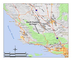
The South Cuyama Oil Field is a large oil and gas field in the Cuyama Valley and the adjacent northern foothills of the Sierra Madre Mountains in northeastern Santa Barbara County, California. Discovered in 1949, and with a cumulative production of around 225 million barrels (35,800,000 m3) of oil, it ranks 27th in size in the state, but is believed to retain only approximately two percent of its original oil, according to the official estimates of the California Department of Oil, Gas, and Geothermal Resources (DOGGR). Of the top forty onshore oil fields in California, it is the most recent to be discovered, but by the end of 2008 only 87 wells remained in production.

<span class="mw-page-title-main">Beverly Hills Oil Field</span> Oil field in Beverley Hills and Los Angeles, California

The Beverly Hills Oil Field is a large and currently active oil field underneath part of the US cities of Beverly Hills, California, and portions of the adjacent city of Los Angeles. Discovered in 1900, and with a cumulative production of over 150 million barrels of oil, it ranks 39th by size among California's oil fields, and is unusual for being a large, continuously productive field in an entirely urban setting. All drilling, pumping, and processing operations for the 97 currently active wells are done from within four large "drilling islands", visible on Pico and Olympic boulevards as large windowless buildings, from which wells slant diagonally into different parts of the producing formations, directly underneath the multimillion-dollar residences and commercial structures of one of the wealthiest cities in the United States. Annual production from the field was 1.09 million barrels in 2006, 966,000 barrels in 2007, and 874,000 in 2008, and the field retains approximately 11 million barrels of oil in reserve, as estimated by the California Department of Conservation. The largest operators as of 2009 were independent oil companies Plains Exploration & Production and BreitBurn Energy.

<span class="mw-page-title-main">Ventura Oil Field</span> Oil field adjacent to the city of Ventura, California, United States

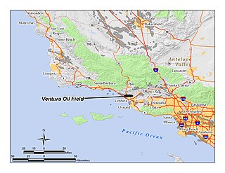
The Ventura Oil Field is a large and currently productive oil field in the hills immediately north of the city of Ventura in southern California in the United States. It is bisected by California State Route 33, the freeway connecting Ventura to Ojai, and is about eight miles (13 km) long by two across, with the long axis aligned east to west. Discovered in 1919, and with a cumulative production of just under a billion barrels of oil as of 2008, it is the tenth-largest producing oil field in California, retaining approximately 50 million barrels in reserve, and had 423 wells still producing. As of 2009 it was entirely operated by Aera Energy LLC.

<span class="mw-page-title-main">Long Beach Oil Field</span> Large oil field underneath cities of California, United States

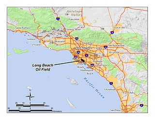
The Long Beach Oil Field is a large oil field underneath the cities of Long Beach and Signal Hill, California, in the United States. Discovered in 1921, the field was enormously productive in the 1920s, with hundreds of oil derricks covering Signal Hill and adjacent parts of Long Beach; largely due to the huge output of this field, the Los Angeles Basin produced one-fifth of the nation's oil supply during the early 1920s. In 1923 alone the field produced over 68 million barrels of oil, and in barrels produced by surface area, the field was the world's richest. The field is eighth-largest by cumulative production in California, and although now largely depleted, still officially retains around 5 million barrels of recoverable oil out of its original 950 million. 294 wells remained in operation as of the beginning of 2008, and in 2008 the field reported production of over 1.5 million barrels of oil. The field is currently run entirely by small independent oil companies, with the largest operator in 2009 being Signal Hill Petroleum, Inc.

<span class="mw-page-title-main">Dos Cuadras Offshore Oil Field</span>

The Dos Cuadras Offshore Oil Field is a large oil and gas field underneath the Santa Barbara Channel about eight miles southeast of Santa Barbara, California. Discovered in 1968, and with a cumulative production of over 260 million barrels of oil, it is the 24th-largest oil field within California and the adjacent waters. As it is in the Pacific Ocean outside of the 3-mile tidelands limit, it is a federally leased field, regulated by the U.S. Department of the Interior rather than the California Department of Conservation. It is entirely produced from four drilling and production platforms in the channel, which as of 2009 were operated by Dos Cuadras Offshore Resources (DCOR), LLC, a private firm based in Ventura. A blowout near one of these platforms – Unocal's Platform A – was responsible for the 1969 Santa Barbara oil spill that was formative for the modern environmental movement, and spurred the passage of the National Environmental Policy Act.

<span class="mw-page-title-main">Brea-Olinda Oil Field</span> Oil field in Orange and Los Angeles Counties, California, United States

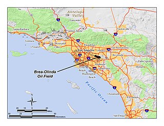
The Brea-Olinda Oil Field is a large oil field in northern Orange County and Los Angeles County, California, along the southern edge of the Puente Hills, about four miles (6 km) northeast of Fullerton, and adjacent to the city of Brea. Discovered in 1880, the field is the sixteenth largest in California by cumulative production, and was the first of California's largest 50 oil fields to be found. It has produced over 412 million barrels of oil in the 130 years since it was first drilled, and retains approximately 19 million barrels in reserve recoverable with current technology. As of the beginning of 2009, 475 wells remained active on the field, operated by several independent oil companies, including Linn Energy, BreitBurn Energy Partners L.P., Cooper & Brain, and Thompson Energy.

<span class="mw-page-title-main">San Miguelito Oil Field</span> Oil field near Ventura, California

The San Miguelito Oil Field is a large and currently productive oil field in the hills northwest of the city of Ventura in southern California in the United States. The field is close to the coastline, with U.S. Highway 101 running past at the base of the hills and is sandwiched between the larger Ventura Oil Field to the east and the Rincon Oil Field, which is partially offshore, to the north and northwest. Discovered in 1931, and with about 7 million barrels of oil remaining out of its original 125 million, it ranks 44th in the state by size, and at the beginning of 2009 had 61 producing oil wells, all operated by Vintage Production California LLC, a subsidiary of Occidental Petroleum.

<span class="mw-page-title-main">Oxnard Oil Field</span> Oil field in Oxnard, California, United States

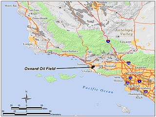
The Oxnard Oil Field is a large and productive oil field in and adjacent to the city of Oxnard, in Ventura County, California in the United States. Its conventional oil reserves are close to exhaustion, with only an estimated one percent of the original oil recoverable with current technology remaining: 434,000 barrels (69,000 m3) out of an original 43.5 million. However, the reservoir includes an enormous deposit of tar sands, ultra-heavy oil classed as an unconventional petroleum reserve, and potentially containing 400 million barrels (64,000,000 m3) of oil equivalent, should it become economically feasible to extract. Present operators on the field include Tri-Valley Oil & Gas Co., Anterra Energy Services, Inc., Chase Production Co., and Occidental Petroleum through its Vintage Production subsidiary. As of the beginning of 2009, there were 34 active wells on the field.

<span class="mw-page-title-main">Saticoy Oil Field</span> Oil and gas field in Ventura County, California, United States

The Saticoy Oil Field is an oil and gas field in Ventura County, California, in the United States. The field is a long narrow band paralleling the Santa Clara River near the town of Saticoy. Discovered in 1955, it is one of the smaller but productive fields found in the region after most of the large fields had already been operational for decades. At the beginning of 2009 it still contained an estimated 387,000 barrels (61,500 m3) of recoverable oil out of its original 23.5 million, and had 15 wells remaining in operation. Vintage Production, a subsidiary of Occidental Petroleum, was the primary operator on the field as of 2009.

<span class="mw-page-title-main">South Mountain Oil Field</span> Oil field adjacent to Santa Paula, California, United States

The South Mountain Oil Field is a large and productive oil field in Ventura County, California, in the United States, in and adjacent to the city of Santa Paula. Discovered in 1916, and having a cumulative production of over 158 million barrels (25,100,000 m3) of oil, it is the 37th largest oil field in California and the second largest in Ventura County. As of the beginning of 2009, it retains 316 active wells, and has an estimated 1.4 million barrels (220,000 m3) of oil remaining recoverable with current technology. Vintage Production, a subsidiary of Occidental Petroleum, was the largest operator as of 2009.

<span class="mw-page-title-main">Guijarral Hills Oil Field</span> Formerly-productive oil and gas field near Coalinga, California, United States

The Guijarral Hills Oil Field is a formerly-productive oil and gas field near Coalinga on the western side of the Central Valley in central California in the United States. Discovered in 1948, and having produced 5.4 million barrels (860,000 m3) of oil during its peak year in 1950, it now has but one active oil well producing a little over a barrel of oil a day, and is very near to exhaustion, with only 343,000 recoverable barrels of oil remaining throughout its 2,515-acre (10.18 km2) extent according to the official California State Department of Conservation estimate. As of 2010, the only active operator was Longview Production Company.

<span class="mw-page-title-main">Mountain View Oil Field</span> Oil field in Kern County, California, United States

The Mountain View Oil Field is a large, mature, but still-productive oil field in Kern County, California, in the United States, in the extreme southern part of the San Joaquin Valley southeast of Bakersfield. It underlies the town of Arvin, as well as some smaller agricultural communities. The field is spread out across a large area, covering just under 8 square miles (21 km2), with wells and storage facilities widely dispersed throughout the area, scattered among working agricultural fields of broccoli and carrots as well as citrus orchards. Discovered in 1933, it has produced over 90 million barrels (14,000,000 m3) of oil in its lifetime, and although declining in production is one of the few inland California fields in which new oil is still being discovered.

<span class="mw-page-title-main">Edison Oil Field</span> Oil field in Kern County, California

The Edison Oil Field is a large oil field in Kern County, California, in the United States, in the southeastern part of the San Joaquin Valley and adjacent foothills east-southeast of Bakersfield. The field has a total productive area of over 8,000 acres (32 km2), most of which is intermingled with agricultural land uses; oil pumps and storage tanks are surrounded with row crops and orchards in much of the field's extent. Discovered in 1928, and with a cumulative production of 149 million barrels (23,700,000 m3) of oil as of 2008, and having over 6 million barrels (950,000 m3) in reserve, it is ranked 38th among California's oil fields by total ultimate recovery. It is a mature field in decline, and is run entirely by small independent operators. As of 2008, there were 40 different oil companies active on the field, one of the most in the state for a single field. 914 wells remained active on the field, averaging only two barrels of oil per well per day from the dwindling reservoirs.

<span class="mw-page-title-main">Los Angeles City Oil Field</span> Oil field in Los Angeles, California

The Los Angeles City Oil Field is a large oil field north of Downtown Los Angeles. Long and narrow, it extends from immediately south of Dodger Stadium west to Vermont Avenue, encompassing an area of about four miles long by a quarter-mile across. Its former productive area amounts to 780 acres (3.2 km2).

<span class="mw-page-title-main">Cat Canyon Oil Field</span>

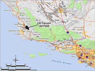
The Cat Canyon Oil Field is a large oil field in the Solomon Hills of central Santa Barbara County, California, about 10 miles southeast of Santa Maria. It is the largest oil field in Santa Barbara County, and as of 2010 is the 20th-largest in California by cumulative production.

<span class="mw-page-title-main">Inglewood Oil Field</span> Oil drilling operation in California, USA

The Inglewood Oil Field in Los Angeles County, California, is the 18th-largest oil field in the state and the second-most productive in the Los Angeles Basin. Discovered in 1924 and in continuous production ever since, in 2012 it produced approximately 2.8 million barrels of oil from some five hundred wells. Since 1924 it has produced almost 400 million barrels, and the California Department of Oil, Gas and Geothermal Resources (DOGGR) has estimated that there are about 30 million barrels remaining in the field's one thousand acres, recoverable with present technology.

<span class="mw-page-title-main">Aliso Canyon Oil Field</span> Oil field in Los Angeles County, California

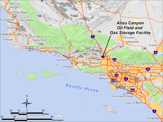
The Aliso Canyon Oil Field is an oil field and natural gas storage facility in the Santa Susana Mountains in Los Angeles County, California, north of the Porter Ranch neighborhood of the City of Los Angeles. Discovered in 1938 and quickly developed afterward, the field peaked as an oil producer in the 1950s, but has remained active since its discovery. One of its depleted oil and gas producing formations, the Sesnon-Frew zone, was converted into a gas storage reservoir in 1973 by the Southern California Gas Company, the gas utility servicing the southern half of California. This reservoir is the second-largest natural gas storage site in the western United States, with a capacity of over 86 billion cubic feet of natural gas. Currently it is one of four gas storage facilities owned by Southern California Gas, the others being the La Goleta Gas Field west of Santa Barbara, Honor Rancho near Newhall, and Playa del Rey.

<span class="mw-page-title-main">Honor Rancho Oil Field</span> Oil and natural gas field adjacent to Santa Clarita, California, United States

The Honor Rancho Oil Field is an approximately 600-acre oil field and natural gas storage facility in Los Angeles County, California, on the northern border of the Valencia neighborhood of Santa Clarita, near the junction of Interstate 5 and westbound California State Route 126. Discovered in 1950 and quickly developed, the field's oil production peaked in the 1950s, but remains productive in 2016. In 1975 Southern California Gas Company (SoCalGas), the gas utility serving Southern California, began using one of its depleted oil producing zones, the Wayside 13 zone, as a gas storage reservoir, and it became the second-largest in their inventory after the Aliso Canyon gas storage facility. The field shares part of its extent with the Peter J. Pitchess Detention Center, which includes a maximum-security prison.

<span class="mw-page-title-main">Dominguez Oil Field</span> Oil field underneath Dominguez Hills, California

The Dominguez Oil Field is a large oil field underneath Dominguez Hills near Carson, California and the California State University, Dominguez Hills. It was a major oil producer from 1923 through 1960. Starting in 2010, oil companies became interested in redeveloping the field using modern extraction technologies.

References

34°04′24″N118°21′12″W / 34.0733°N 118.3532°W / 34.0733; -118.3532