Los Angeles County Department of Public Works

Last updated
Los Angeles County Department of Public Works
LACDPW logo.svg
Department overview
Formed1985 (1985) (Merger)
Preceding agencies
  • County Engineer
  • Flood Control District
  • Road Department
Jurisdiction Los Angeles County, California
Headquarters Alhambra, California
Employees4,269 (2016) [1]
Annual budget$2,448,066,000 (2016) [2]
Department executive
  • Mark Pestrella, Director
Website www.pw.lacounty.gov

The Los Angeles County Department of Public Works (LACDPW) is responsible for the construction and operation of Los Angeles County's roads, building safety, sewerage, and flood control. DPW also operates traffic signals and intelligent transportation systems, drinking water systems in certain communities, operates five airports, paratransit and fixed route public transport, administers various environment programs, issues various permits for activities in the public roadway, and has a Department Emergency Operations Center that works in conjunction with the County Emergency Operations Center operated by the Sheriff's Department. The department is headquartered at 900 South Fremont Avenue in Alhambra, California. [3]

Contents

Services are provided primarily to the unincorporated county with some services provided to contract cities. Flood control and watershed management services are provided to all of the county except the Antelope Valley.

As part of its flood control and water supply responsibilities, the Department of Public Works has 15 major dams and 27 spreading grounds in the county. [4] Pacoima Dam is one of the largest owned by Public Works and survived the Northridge earthquake in 1994 intact.

Water from the dams is released into flood-control channels and some is diverted into spreading basins where it percolates into the ground and recharges the groundwater. The surface water is not used directly as it requires more cleaning than groundwater. Near the coast, the department has constructed sea water barriers that use injection wells to create a fresh water barrier to prevent salt water intrusion from the ocean into the groundwater. [5]

The DPW is a leader in watershed management. It provides storm drain education programs, publishes and enforces best management practices for activities that may affect the watershed, and manages watersheds to provide a balance between flood control, recreation, and protecting the natural environment.

History

A Los Angeles County Department of Public Works sign along 7th Street in downtown Los Angeles. Public works sign on 7th Street in Los Angeles - February 2024 - Sarah Stierch.jpg
A Los Angeles County Department of Public Works sign along 7th Street in downtown Los Angeles.

The department was formed in 1985 in a consolidation of the county Road Department, the Flood Control District (in charge of dams, spreading grounds, and channels), and the County Engineer (in charge of building safety, land survey, waterworks).

For 25 years, the County Engineer Department was housed in the historic Higgins Building, a 10-story Beaux-Arts style commercial building that was designed and built by noted architect Arthur L. Haley and engineer Albert Carey Martin in 1910, at the corner of Second and Main Streets in Downtown Los Angeles. After "overseeing construction projects large and small from one of the city's strongest buildings, the county determined that the department needed more modern quarters and pulled up stakes in 1977," according to the Los Angeles City Planning Department, which designated the building as the Historic-Cultural Monument #873.

In 1977, the County Engineer Department moved to the corner of 5th Street and Vermont Ave., Los Angeles until the merge of the three departments. At that time the department was called the Department of County Engineer-Facilities.

In 1988, the department issued a demolition permit to tear down the historic Golden Gate Theater in East Los Angeles. Demolition commenced before officials led by then County Supervisor Ed Edelman halted the work with a stop-work order. [6] Demolition crews had already begun to dismantle the walls when Edelman, then Los Angeles City Councilwoman Gloria Molina, sheriff's deputies and more than 50 concerned community members showed up at the site to ensure the demolition work was halted. Edelman blamed a "foul-up" in the Public Works Department for issuing the demolition permit and assured the gathered crowd that heads were going to roll and that he would "try and stop this damn demolition before it happens." [6] [7]

For years, the Flood Control District and the County Road Department were headquartered in buildings at Alcazar Street in East Los Angeles by the Los Angeles County General Hospital.

Major divisions of the Public Works Department were located at various locations in Los Angeles city for a number of years, until the 12-story glass building in Alhambra, California was purchased and refurbished. This tallest structure in Alhambra was formerly the western headquarters of Sears, Roebuck and Company, where some fixture units still bear the label "Sears". The steel frames were strengthened in 2006 after it was learned from the Northridge earthquake that the welded joints were not adequate to withstand a major earthquake. [8]

Former Directors

Major Divisions

[10]

Routes

County Shuttles

LACDPW operates shuttles in unincorporated areas of the county, and funds other agencies that provide service. [11]

RouteTerminalsViaNotesSchedule
Acton & Agua Dulce Shuttle Santa Clarita
Santa Clarita station
Acton
Sierra Hwy & Crown Valley Rd
Sierra Hwy
  • Operates Monday, Wednesday and Saturday
Schedule
Avocado Heights/Bassett/West Valinda Shuttle Avocado Heights
Don Julian Rd & Avocado Heights Park
Bassett
Sunkist Av & Hayland St
Don Julian Rd
  • Operates Monday–Saturday
Schedule
Heights Hopper Shuttle Hacienda Heights
Valencia Av & Palm Av
Rowland Heights
Rowland Heights Park
Colima Rd Schedule
East Valinda Shuttle Valinda
Rimgrove Park
South San Jose Hills
Nogales High School
Azusa Av, Valley Bl
  • Operates Monday–Saturday
Schedule
Edmund D. Edelman Children's Court Shuttle Los Angeles
Cal State LA station
Monterey Park
Edmund D. Edelman Children's Court
Campus Rd Schedule
Topanga Canyon Beach Bus Warner Center
Warner Center station
Santa Monica
Downtown Santa Monica station
Topanga Canyon Bl Schedule
Wellness Center ShuttleLos Angeles
Los Angeles General Medical Center
State St
  • Operates Monday–Friday
  • Loop route
  • Fare-free service
Schedule

El Sol

El Sol is the shuttle system serving East Los Angeles.

RouteTerminalsViaNotesSchedule
Whittier Boulevard/Saybrook Park East Los Angeles
Dionicio Morales Transit Plaza
Whittier Bl Schedule
Union Pacific/Salazar ParkIndiana St
  • Serves East LA Civic Center station, Maravilla station and Indiana station
  • Counter Clockwise route
City Terrace/ELACCesar Chavez Av
  • Serves East LA Civic Center station, Cal State LA Transit Center, East Los Angeles College and Atlantic station
  • Clockwise route
RouteTerminalsViaNotesSchedule
Athens Shuttle West Athens
120th St & Western Av
108th St Schedule
Baldwin Hills Parklands Shuttle Ladera Heights
Kenneth Hahn State Recreation Area
La Cienega Bl Schedule
Florence-Firestone/Walnut Park Shuttle Florence-Graham
Firestone station
Florence Av Schedule
King Medical Center Shuttle Willowbrook
119th St & Hahn's Shopping Plaza
Willowbrook Av Schedule
Lennox Shuttle Lennox
Lennox Bl & Firmona Av
104th St Schedule
Willowbrook ShuttleAWillowbrook
119th St & Hahn's Shopping Plaza
Willowbrook
San Pedro St & 135th St
El Segundo Bl Schedule
BWillowbrook
119th St & Hahn's Shopping Plaza
Mona Bl
  • Serves Willowbrook/Rosa Parks station
  • Clockwise route

Sunshine Shuttle

Sunshine Shuttle is the shuttle system serving South Whittier.

RouteTerminalsViaNotesSchedule
A Whittier
Whittwood Town Center
Whittier
Whittier Bl & Sorenson Av
Painter Av Schedule
BWhittier
Whittwood Town Center
Whittier Bl
  • Clockwise and Counter Clockwise routes
C West Whittier-Los Nietos
Broadway Av & Sorensen Park
Norwalk Bl
  • Clockwise route
Schedule

See also

Related Research Articles

<span class="mw-page-title-main">Stormwater</span> Water that originates during precipitation events and snow/ice melt

Stormwater, also written storm water, is water that originates from precipitation (storm), including heavy rain and meltwater from hail and snow. Stormwater can soak into the soil (infiltrate) and become groundwater, be stored on depressed land surface in ponds and puddles, evaporate back into the atmosphere, or contribute to surface runoff. Most runoff is conveyed directly as surface water to nearby streams, rivers or other large water bodies without treatment.

<span class="mw-page-title-main">Santa Clara River (California)</span> River in Ventura and Los Angeles counties, California

The Santa Clara River is an 83 mi (134 km) long river in Ventura and Los Angeles counties in Southern California. It drains parts of four ranges in the Transverse Ranges System north and northwest of Los Angeles, then flows west onto the Oxnard Plain and into the Santa Barbara Channel of the Pacific Ocean.

<span class="mw-page-title-main">Dry well</span> Pit to allow surface waste water to drain

A dry well or drywell is an underground structure that disposes of unwanted water, most commonly surface runoff and stormwater, in some cases greywater or water used in a groundwater heat pump. It is a gravity-fed, vertical underground system that can capture surface water from impervious surfaces, then store and gradually infiltrate the water into the groundwater aquifer.

<span class="mw-page-title-main">Santa Ana River</span> River in California, United States

The Santa Ana River is the largest river entirely within Southern California in the United States. It rises in the San Bernardino Mountains and flows for most of its length through San Bernardino and Riverside counties, before cutting through the northern Santa Ana Mountains via Santa Ana Canyon and flowing southwest through urban Orange County to drain into the Pacific Ocean. The Santa Ana River is 96 miles (154 km) long, and its drainage basin is 2,650 square miles (6,900 km2) in size.

<span class="mw-page-title-main">Seven Oaks Dam</span> Dam in near Mentone, California

Seven Oaks Dam is a 550-foot (170 m) high earth and rock fill embankment dam across the Santa Ana River in the San Bernardino Mountains, about 4 miles (6.4 km) northeast of Redlands in San Bernardino County, southern California. It impounds Seven Oaks Reservoir in the San Bernardino National Forest.

<span class="mw-page-title-main">San Gabriel River (California)</span> River in Los Angeles County, California, United States

The San Gabriel River is a mostly urban waterway flowing 58 miles (93 km) southward through Los Angeles and Orange Counties, California in the United States. It is the central of three major rivers draining the Greater Los Angeles Area, the others being the Los Angeles River and Santa Ana River. The river's watershed stretches from the rugged San Gabriel Mountains to the heavily developed San Gabriel Valley and a significant part of the Los Angeles coastal plain, emptying into the Pacific Ocean between the cities of Long Beach and Seal Beach.

<span class="mw-page-title-main">Prado Dam</span> Dam in Riverside County, California

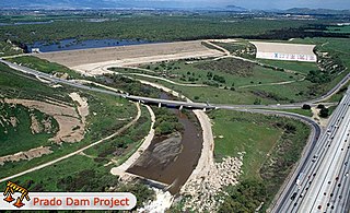
Prado Dam is an earth-fill dry dam across the Santa Ana River at the Chino Hills near Corona, California in Riverside County with the resulting impounded water creating Prado Flood Control Basin reservoir. The U.S. Army Corps of Engineers built the dam in Lower Santa Ana River Canyon. Its primary purpose is flood control and it is the downstream element of the Santa Ana River's flood control system, which is a natural constriction about 30.5 mi (49.1 km) upstream from the ocean. The area upstream from the dam contains 2,255 sq mi (5,840 km2) of the watershed's 2,650 sq mi (6,900 km2). The dam's construction was authorized in 1936 and the flood of 1938 demonstrated its necessity. Construction was completed in 1941. Prado Flood Control Basin also provides water storage for groundwater recharge operations.

<span class="mw-page-title-main">Arroyo Seco (Los Angeles County)</span> Seasonal watercourse and human settlement in US

The Arroyo Seco, meaning "dry stream" in Spanish, is a 24.9-mile-long (40.1 km) seasonal river, canyon, watershed, and cultural area in Los Angeles County, California. The area was explored by Gaspar de Portolà who named the stream Arroyo Seco as this canyon had the least water of any he had seen. During this exploration he met the Chief Hahamog-na (Hahamonga) of the Tongva Indians.

<span class="mw-page-title-main">Hansen Dam</span> Dam in San Fernando Valley

Hansen Dam is a flood control dam in the northeastern San Fernando Valley, in the Lake View Terrace neighborhood of Los Angeles, California. The dam was built by the U.S. Army Corps of Engineers, Los Angeles District in 1940. Hansen Dam was named after horse ranchers Homer and Marie Hansen, who established a ranch in the 19th century.

<span class="mw-page-title-main">Rain garden</span> Runoff reducing landscaping method

Rain gardens, also called bioretention facilities, are one of a variety of practices designed to increase rain runoff reabsorption by the soil. They can also be used to treat polluted stormwater runoff. Rain gardens are designed landscape sites that reduce the flow rate, total quantity, and pollutant load of runoff from impervious urban areas like roofs, driveways, walkways, parking lots, and compacted lawn areas. Rain gardens rely on plants and natural or engineered soil medium to retain stormwater and increase the lag time of infiltration, while remediating and filtering pollutants carried by urban runoff. Rain gardens provide a method to reuse and optimize any rain that falls, reducing or avoiding the need for additional irrigation. A benefit of planting rain gardens is the consequential decrease in ambient air and water temperature, a mitigation that is especially effective in urban areas containing an abundance of impervious surfaces that absorb heat in a phenomenon known as the heat-island effect.

<span class="mw-page-title-main">Ventura River</span> River in western Ventura County in southern California, United States

The Ventura River, in western Ventura County in southern California, United States, flows 16.2 miles (26.1 km) from its headwaters to the Pacific Ocean. The smallest of the three major rivers in Ventura County, it flows through the steeply sloped, narrow Ventura Valley, with its final 0.7 miles (1.1 km) through the broader Ventura River estuary, which extends from where it crosses under a 101 Freeway bridge through to the Pacific Ocean.

The Council for Watershed Health (CWH) is a nonprofit environmental organization in the U.S. state of California. It was founded in 1996 by Dorothy Green to preserve, restore, and enhance the Los Angeles and San Gabriel River watersheds. To accomplish this, it has brought together representatives from the regional water agencies, as well as government regulatory agencies ; community and environmental citizen groups; and businesses in the Los Angeles Basin watershed.

<span class="mw-page-title-main">Santa Fe Dam</span> Dam in Irwindale, California

Santa Fe Dam is a flood-control dam on the San Gabriel River located in Irwindale in Los Angeles County, California, United States. For most of the year, the 92-foot (28 m)-high dam and its reservoir lie empty, but can hold more than 45,000 acre-feet (56,000,000 m3) of water during major storms. During the dry season, the basin behind the dam is used for groundwater recharge, as well as various recreational activities.

<span class="mw-page-title-main">San Gabriel Dam</span> Dam in Los Angeles County, California

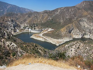
San Gabriel Dam is a rock-fill dam on the San Gabriel River in Los Angeles County, California, within the Angeles National Forest. Completed in 1939, the dam impounds the main stem of the San Gabriel River about 2.5 miles (4.0 km) downstream from the confluence of the river's East and West Forks, which drain a large portion of the San Gabriel Mountains. It is located directly upstream from the Morris Dam. The dam provides flood control, groundwater recharge flows and hydroelectricity for the heavily populated San Gabriel Valley in the Greater Los Angeles metropolitan area.

<span class="mw-page-title-main">Santa Anita Dam</span> Dam in Sierra Madre, California

Santa Anita Dam, also known as Big Santa Anita Dam, is a concrete thin arch dam on Santa Anita Creek in the San Gabriel Mountains of Los Angeles County, California. Owned by the Los Angeles County Flood Control District, the dam serves for flood control, water conservation and debris control. The dam is 225 feet (69 m) high and 612 feet (187 m) long, holding 858 acre-feet (1,058,000 m3) of water with a maximum capacity of 1,028 acre⋅ft (1,268,000 m3). The catchment area for the dam is 10.8 square miles (28 km2). The dam was built between 1923 and 1927. The dam has three valves that control releases of stormwater.

<span class="mw-page-title-main">Morris Dam</span> Dam in Los Angeles County, California

Morris Dam is a concrete gravity dam across the San Gabriel River in the U.S. state of California. It impounds Morris Reservoir, directly downstream of San Gabriel Dam.

<span class="mw-page-title-main">Big Tujunga Dam</span> Dam in Los Angeles County, California

Big Tujunga Dam is a 244-foot-high (74 m) concrete arch dam in Los Angeles County, California, spanning Big Tujunga Canyon northeast of Sunland, in the foothills of the San Gabriel Mountains. Completed in 1931, it provides flood control and groundwater recharge for the San Fernando Valley.

<span class="mw-page-title-main">Nacimiento Dam</span> Dam in San Luis Obispo County, California

Nacimiento Dam is a dam on the Nacimiento River about 10 miles (16 km) northwest of Paso Robles, California in the United States. The primary purpose of the dam is to provide groundwater recharge for agriculture in Monterey County and northern San Luis Obispo County supported by the Salinas Valley aquifer, as well as flood control, domestic water supply, and hydropower. It forms Lake Nacimiento, popular for boating, fishing and camping, and known locally as the "Dragon Lake" due to its shape.

<span class="mw-page-title-main">Government of Los Angeles County</span>

The Government of Los Angeles County is defined and authorized under the California Constitution, California law, and the Charter of the County of Los Angeles. Much of the Government of California is in practice the responsibility of county governments, such as the Government of Los Angeles County. The County government provides countywide services such as elections and voter registration, law enforcement, jails, vital records, property records, tax collection, public health, health care, and social services. In addition the County serves as the local government for all unincorporated areas.

<span class="mw-page-title-main">Big Dalton Dam</span> Flood control dam in Los Angeles County, California, USA

Big Dalton Dam is a multiple arch concrete dam in Los Angeles County, California, built for the Los Angeles County Flood Control District and completed in August 1929. The dam is one of the earliest of the multiple arch "double-wall" buttress designs of engineer Fred A. Noetzli. The 991 acre-foot dam provides water conservation and controls flooding from Big Dalton Canyon, a watershed within the San Dimas Experimental Forest, part of the Angeles National Forest in the San Gabriel Mountains. It is about 4 miles northeast of the city of Glendora and is operated by the Los Angeles County Department of Public Works.

References

  1. "Recommended Budgeted Positions 2016–2017" (PDF). County of Los Angeles. Chief Executive Office. p. 2. Retrieved 26 October 2016.
  2. "2016–17 Recommended Budget" (PDF). County of Los Angeles. Chief Executive Office. p. 543. Retrieved 26 October 2016.
  3. "Contact Public Works." Los Angeles County Department of Public Works. Retrieved on September 27, 2009.
  4. Stevens, Matt (August 25, 2016). "L.A. betting that stormwater can help ease California's drought". Los Angeles Times . Retrieved 28 August 2016.
  5. Amy Pyle and Leslie Berger, Boy's Death Prompts Calls for Changes, Los Angeles Times, February 15, 1992
  6. 1 2 Penelope McMillan (1988-03-17). "Curtain Call for a Landmark Theater". Los Angeles Times. "Demolition crews had swept onto the site at the corner of Whittier and Atlantic boulevards Tuesday and Wednesday, and began to dismantle some walls. But they were halted by a stop-work order obtained from the county Public Works Department through the efforts of Supervisor Ed Edelman."
  7. Future of 1927-era East L.A. theater in question, May 14, 2009
  8. Lynn O'Shaughnessy and Tracy Wood, County Skirts the Rules; Campaign Donor Profits Big, Los Angeles Times, November 7, 1988
  9. Los Angeles County Public Works Director Will Retire After 38 Years, Los Angeles Times, January 06, 1994
  10. "Archived copy" (PDF). Archived from the original (PDF) on 2012-09-04. Retrieved 2012-01-28.{{cite web}}: CS1 maint: archived copy as title (link)
  11. LAGoBus.info

34°05′9″N118°08′56″W / 34.08583°N 118.14889°W / 34.08583; -118.14889