South San Jose Hills, California

Last updated

South San Jose Hills, California
LA County Incorporated Areas South San Jose Hills highlighted.svg
Location of South San Jose Hills in Los Angeles County, California.
Usa edcp location map.svg
Red pog.svg
South San Jose Hills, California
Location in the United States
Coordinates: 34°0′41″N117°54′17″W / 34.01139°N 117.90472°W / 34.01139; -117.90472
Country Flag of the United States.svg United States
State Flag of California.svg  California
County Flag of Los Angeles County, California.svg Los Angeles
Area
[1]
  Total1.508 sq mi (3.905 km2)
  Land1.508 sq mi (3.905 km2)
  Water0 sq mi (0 km2)  0%
Elevation
417 ft (127 m)
Population
 (2010)
  Total20,551
  Density14,000/sq mi (5,300/km2)
Time zone UTC-8 (PST)
  Summer (DST) UTC-7 (PDT)
ZIP code
91744
Area code 626
FIPS code 06-73290
GNIS feature ID 1867058

South San Jose Hills is an unincorporated community and census-designated place in Los Angeles County, California, United States. The population was 20,551 at the 2010 census, up from 20,218 at the 2000 census.

Contents

Geography

South San Jose Hills is an unincorporated, mainly residential community located on the southern end of the San Jose Hills, which forms a part of San Gabriel Valley.

South San Jose Hills is bounded by City of Industry to the south, La Puente to the west, West Covina to the north, and Walnut to the east. The community is easily accessible via the Pomona Freeway (State Route 60), which runs just south of the community. The ZIP code serving the community is 91744. Most addresses do not use South San Jose Hills as the city but rather La Puente, West Covina, or Valinda, depending on the location of the residence or business. Parts of the area are nicknamed Happy Homes, based on the former name of the development and on the street gang that later took that name.

Demographics

Historical population
CensusPop.Note
1970 12,386
1980 16,04929.6%
1990 17,81411.0%
2000 20,21813.5%
2010 20,5511.6%

2010

At the 2010 census South San Jose Hills had a population of 20,551. The population density was 13,628.8 inhabitants per square mile (5,262.1/km2). The racial makeup of South San Jose Hills was 9,302 (45.3%) White (4.2% Non-Hispanic White), [2] 304 (1.5%) African American, 195 (0.9%) Native American, 1,649 (8.0%) Asian, 30 (0.1%) Pacific Islander, 8,449 (41.1%) from other races, and 622 (3.0%) from two or more races. Hispanic or Latino of any race were 17,713 persons (86.2%). [3]

The census reported that 20,524 people (99.9% of the population) lived in households, 27 (0.1%) lived in non-institutionalized group quarters, and no one was institutionalized.

There were 4,112 households, 2,507 (61.0%) had children under the age of 18 living in them, 2,565 (62.4%) were opposite-sex married couples living together, 730 (17.8%) had a female householder with no husband present, 405 (9.8%) had a male householder with no wife present. There were 215 (5.2%) unmarried opposite-sex partnerships, and 22 (0.5%) same-sex married couples or partnerships. 285 households (6.9%) were one person and 122 (3.0%) had someone living alone who was 65 or older. The average household size was 4.99. There were 3,700 families (90.0% of households); the average family size was 4.86.

The age distribution was 6,250 people (30.4%) under the age of 18, 2,596 people (12.6%) aged 18 to 24, 5,791 people (28.2%) aged 25 to 44, 4,274 people (20.8%) aged 45 to 64, and 1,640 people (8.0%) who were 65 or older. The median age was 29.7 years. For every 100 females, there were 101.4 males. For every 100 females age 18 and over, there were 98.7 males.

There were 4,239 housing units at an average density of 2,811.2 per square mile, of the occupied units 3,131 (76.1%) were owner-occupied and 981 (23.9%) were rented. The homeowner vacancy rate was 1.0%; the rental vacancy rate was 3.2%. 15,294 people (74.4% of the population) lived in owner-occupied housing units and 5,230 people (25.4%) lived in rental housing units.

According to the 2010 United States Census, South San Jose Hills had a median household income of $50,864, with 16.2% of the population living below the federal poverty line. [2]

2000

At the 2000 census there were 20,218 people, 3,984 households, and 3,605 families in the CDP. The population density was 13,876.4 inhabitants per square mile (5,357.7/km2). There were 4,059 housing units at an average density of 2,785.8 per square mile (1,075.6/km2). The racial makeup of the CDP was 38.76% White, 1.86% African American, 1.54% Native American, 6.54% Asian, 0.35% Pacific Islander, 46.35% from other races, and 4.59% from two or more races. Hispanic or Latino of any race were 83.43%. [4]

Of the 3,984 households 53.2% had children under the age of 18 living with them, 67.4% were married couples living together, 14.4% had a female householder with no husband present, and 9.5% were non-families. 6.7% of households were one person and 3.0% were one person aged 65 or older. The average household size was 5.07 and the average family size was 4.95.

The age distribution was 34.6% under the age of 18, 12.0% from 18 to 24, 30.8% from 25 to 44, 16.7% from 45 to 64, and 5.9% 65 or older. The median age was 27 years. For every 100 females, there were 100.2 males. For every 100 females age 18 and over, there were 99.0 males.

The median household income was $48,655 and the median family income was $46,702. Males had a median income of $26,477 versus $22,113 for females. The per capita income for the CDP was $11,324. About 13.4% of families and 18.5% of the population were below the poverty line, including 23.7% of those under age 18 and 9.7% of those age 65 or over.

Politics

In the state legislature South San Jose Hills is located in the 24th Senate District, represented by Democrat Gloria Romero, and in the 58th Assembly District, represented by Democrat Charles M. Calderon. Federally, South San Jose Hills is split between 32nd and 39th congressional districts, which are represented by Democrats Grace Napolitano and Gil Cisneros, respectively. At the county level, South San Jose Hills is part of Los Angeles County's first district and is currently represented by Hilda Solis.

Education

It is within the Rowland Unified School District. [5]

Related Research Articles

<span class="mw-page-title-main">San Carlos, Arizona</span> CDP in Gila County, Arizona

San Carlos is a census-designated place (CDP) in Gila County, Arizona, United States. The population was 4,038 at the 2010 census, up from 3,716 in 2000.

<span class="mw-page-title-main">Sunol, California</span> Census-designated place in California, United States

Sunol is an unincorporated area and census-designated place in Alameda County, California. Located in the Sunol Valley of the East Bay, the population was 913 at the 2010 census. It is best known as the location of the Sunol Water Temple and for its historic tourist railroad system, the Niles Canyon Railway.

<span class="mw-page-title-main">Golden Hills, California</span> Census-designated place in California, United States

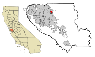
Golden Hills is a census-designated place (CDP) in the Tehachapi Mountains, in Kern County, California, United States. The population was 8,656 at the 2010 census, up from 7,434 at the 2000 census. Golden Hills adjoins the city of Tehachapi on the west.

<span class="mw-page-title-main">Charter Oak, California</span> Census designated place in California, United States

Charter Oak is a census-designated place (CDP) in Los Angeles County, California, approximately 26 miles (42 km) east of downtown Los Angeles. The population was 9,310 at the 2010 census, up from 9,027 at the 2000 census.

<span class="mw-page-title-main">East San Gabriel, California</span> Census-designated place in California, United States

East San Gabriel is a census-designated place (CDP) in Los Angeles County, California, United States. The population was 14,874 at the 2010 census, up from 14,512 at the 2000 census.

<span class="mw-page-title-main">South San Gabriel, California</span> Census-designated place in California, United States

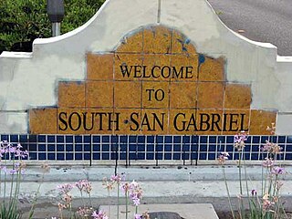
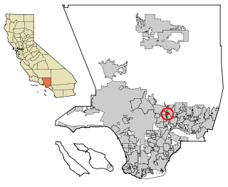
South San Gabriel is a census-designated place (CDP) in Los Angeles County, California, United States. The population was 8,070 at the 2010 census, up from 7,595 at the 2000 census.

<span class="mw-page-title-main">Las Lomas, California</span> Census-designated place in California, United States

Las Lomas is an unincorporated community and census-designated place (CDP) in Monterey County, California, United States. Las Lomas is located 7 miles (11 km) north-northwest of Prunedale. The elevation is 43 feet (13 m). The population was 3,046 at the 2020 census.

<span class="mw-page-title-main">Lake San Marcos, California</span> Census-designated place in California, United States

Lake San Marcos is a census-designated place (CDP) in the North County region of the San Diego metropolitan area. It is nominally independent of San Marcos proper, but functionally subservient to the city.

<span class="mw-page-title-main">East Foothills, San Jose</span> Census designated place in California, United States

East Foothills is a census-designated place (CDP) in Santa Clara County, California, United States and a neighborhood of San Jose. The population was 8,269 at the 2010 census and it is located about 4 miles east of downtown San Jose.

<span class="mw-page-title-main">Fruitdale, San Jose</span> Place in California, United States

Fruitdale is a district of San Jose, California, located in West San Jose, though some portions are still unincorporated as a census-designated place. The population of the CDP was 935 at the 2010 census.

<span class="mw-page-title-main">Seven Trees, San Jose</span> Neighborhood of San Jose in Santa Clara, California, United States

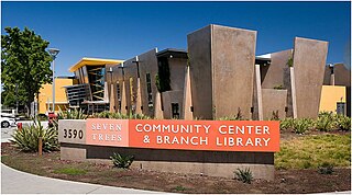
Seven Trees is a Neighborhood of San Jose, California. It was formerly an unincorporated census-designated place surrounded completely by South San Jose and it was annexed into San Jose on November 23, 2009.

<span class="mw-page-title-main">Woodstock Township, Michigan</span> Civil township in Michigan, United States

Woodstock Township is a civil township of Lenawee County, Michigan, United States. As of the 2000 census, the township population was 3,468.

<span class="mw-page-title-main">North Acomita Village, New Mexico</span> Census-designated place in New Mexico, United States

North Acomita Village is a census-designated place (CDP) in Cibola County, New Mexico, United States. The population was 303 at the 2010 census.

<span class="mw-page-title-main">Paraje, New Mexico</span> Census-designated place in New Mexico, United States

Paraje is a census-designated place (CDP) in Cibola County, New Mexico, United States. As of the 2010 census, the CDP population was 777.

<span class="mw-page-title-main">Nenahnezad, New Mexico</span> CDP in New Mexico, United States

Nenahnezad is a census-designated place (CDP) in San Juan County, New Mexico, United States. The population was 726 at the 2000 census. Nenahnezad is a Chapter community just to the south of Fruitland, between the towns of Farmington and Shiprock. It is part of the Farmington Metropolitan Statistical Area.

<span class="mw-page-title-main">Fruit Hill, Ohio</span> Census-designated place in Ohio, United States

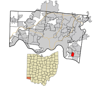
Fruit Hill is a census-designated place (CDP) in Hamilton County, Ohio, United States. The population was 3,748 at the 2020 census.

Sand Hill is an unincorporated community and census-designated place (CDP) in Lebanon County, Pennsylvania, United States. The population was 2,496 at the 2010 census.

<span class="mw-page-title-main">Colonial Pine Hills, South Dakota</span> CDP in South Dakota, United States

Colonial Pine Hills is a census-designated place (CDP) and unincorporated community in Pennington County, South Dakota, United States. The population was 1,903 at the 2020 census.

<span class="mw-page-title-main">Rapid Valley, South Dakota</span> CDP in South Dakota, United States

Rapid Valley is a census-designated place (CDP) and unincorporated community in Pennington County, South Dakota, United States, and a suburb of Rapid City. The population was 8,098 at the 2020 census. Rapid Valley has been a retreat for people living in Rapid City due to its low crime, cheap land, and views of the Black Hills. Rapid Valley is home to many industrial and financial businesses, and is the headquarters for many corporations specializing in transport and engineering.

<span class="mw-page-title-main">Indian Hills, Texas</span> Census-designated place in Texas

Indian Hills is a census-designated place (CDP) in Hidalgo County, Texas, United States. At the 2010 United States Census, the population was 2,591. It is part of the McAllen–Edinburg–Mission Metropolitan Statistical Area.

References

  1. "2010 Census U.S. Gazetteer Files – Places – California". United States Census Bureau.
  2. 1 2 "New census link".
  3. "2010 Census Interactive Population Search: CA - South San Jose Hills CDP". U.S. Census Bureau. Archived from the original on July 15, 2014. Retrieved July 12, 2014.
  4. "U.S. Census website". United States Census Bureau . Retrieved January 31, 2008.
  5. "2020 CENSUS - SCHOOL DISTRICT REFERENCE MAP: Los Angeles County, CA" (PDF). U.S. Census Bureau. p. 11 (PDF p. 12/19). Retrieved November 25, 2023.