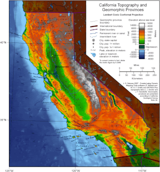
California is a U.S. state on the western coast of North America. Covering an area of 163,696 sq mi (423,970 km2), California is among the most geographically diverse states. The Sierra Nevada, the fertile farmlands of the Central Valley, and the arid Mojave Desert of the south are some of the major geographic features of this U.S. state. It is home to some of the world's most exceptional trees: the tallest, most massive, and oldest. It is also home to both the highest and lowest points in the 48 contiguous states. The state is generally divided into Northern and Southern California, although the boundary between the two is not well defined. San Francisco is decidedly a Northern California city and Los Angeles likewise a Southern California one, but areas in between do not often share their confidence in geographic identity. The US Geological Survey defines the geographic center of the state at a point near North Fork, California.
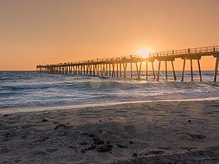
Southern California is a geographic and cultural region that generally comprises the southern portion of the U.S. state of California. It includes the Los Angeles metropolitan area and also the Inland Empire. The region generally contains ten of California's 58 counties: Imperial, Kern, Los Angeles, Orange, Riverside, San Bernardino, San Diego, Santa Barbara, San Luis Obispo and Ventura counties.

Wrightwood is a census-designated place in San Bernardino County, California. It sits at an elevation of 6,000 feet (1,800 m). The population was 4,525 at the 2010 census, up from the population of 3,837 at the 2000 census. Wrightwood is located 77 miles (124 km) northeast of Los Angeles. Wrightwood is on the Pacific Crest Trail.

The San Gabriel Mountains are a mountain range located in northern Los Angeles County and western San Bernardino County, California, United States. The mountain range is part of the Transverse Ranges and lies between the Los Angeles Basin and the Mojave Desert, with Interstate 5 to the west and Interstate 15 to the east. The range lies in, and is surrounded by, the Angeles and San Bernardino National Forests, with the San Andreas Fault as its northern border.

The San Bernardino Mountains are a high and rugged mountain range in Southern California in the United States. Situated north and northeast of San Bernardino and spanning two California counties, the range tops out at 11,503 feet (3,506 m) at San Gorgonio Mountain – the tallest peak in Southern California. The San Bernardinos form a significant region of wilderness and are popular for hiking and skiing.

The San Jacinto Mountains are a mountain range in Riverside County, located east of Los Angeles in southern California in the United States. The mountains are named for one of the first Black Friars, Saint Hyacinth, who is a popular patron in Latin America.

The Angeles National Forest (ANF) of the U.S. Forest Service is located in the San Gabriel Mountains and Sierra Pelona Mountains, primarily within Los Angeles County in southern California. The ANF manages a majority of the San Gabriel Mountains National Monument.
The 1857 Fort Tejon earthquake occurred at about 8:20 a.m. on January 9 in central and Southern California. One of the largest recorded earthquakes in the United States, with an estimated moment magnitude of 7.9, it ruptured the southern part of the San Andreas Fault for a length of about 225 miles, between Parkfield and Wrightwood.

Mount San Antonio, commonly referred to as Mount Baldy or Old Baldy, is a 10,064 ft (3,068 m) summit in the San Gabriel Mountains on the border of Los Angeles and San Bernardino counties of California. Lying within the San Gabriel Mountains National Monument and Angeles National Forest, it is the high point of the range, the County of Los Angeles, and the Los Angeles metropolitan area.
The Angeles Crest Highway is a two-lane highway over the San Gabriel Mountains, in Los Angeles County, California. Its route is to/through the San Gabriel Mountains National Monument and the Angeles National Forest. With the exception of a 1,000 feet (300 m)-long section in La Cañada Flintridge, the entire route is part of California State Route 2.

The San Bernardino National Forest is a United States National Forest in Southern California encompassing 823,816 acres (3,333.87 km2) of which 677,982 acres (2,743.70 km2) are federal. The forest is made up of two main divisions, the eastern portion of the San Gabriel Mountains and the San Bernardino Mountains on the easternmost of the Transverse Ranges, and the San Jacinto and Santa Rosa Mountains on the northernmost of the Peninsular Ranges. Elevations range from 2,000 to 11,499 feet. The forest includes seven wilderness areas: San Gorgonio, Cucamonga, San Jacinto, South Fork, Santa Rosa, Cahuilla Mountain and Bighorn Mountain. Forest headquarters are located in the city of San Bernardino. There are district offices in Lytle Creek, Idyllwild, and Fawnskin.

Mountain High resort is a winter resort in the San Gabriel Mountains in Los Angeles County in California. Mountain High is one of the most-visited resorts in Southern California. The resort is located along State Route 2 west of Wrightwood, California. The elevation of the resort is 6,600 feet (2,000 m) to 8,200 feet (2,500 m) for the Mountain High East Resort, 7,000 feet (2,100 m) to 8,000 feet (2,400 m) for the West Resort and 7,200 feet (2,200 m) to 7,800 ft (2,400 m) for the North Resort.

Mount Pinos is a mountain located in the Los Padres National Forest on the boundary between Ventura and Kern counties in California. The summit, at 8,847 feet (2,697 m), is the highest point in Ventura County. The mountain is the highest point of the Transverse Ranges west of Tejon Pass, as well as the southernmost point of the Salinian Block.
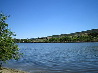
Elizabeth Lake is a natural sag pond that lies directly on the San Andreas Fault in the northern Sierra Pelona Mountains, in northwestern Los Angeles County, southern California.

Devil's Punchbowl is a tilted sandstone formation on the northern slopes of the San Gabriel Mountains, in Los Angeles County, California, at an elevation of 4,750 feet (1,450 m).

Forest Falls is an unincorporated community in San Bernardino County, California, 75 miles (121 km) due east of Los Angeles. The community has a population of 1,102 and contains 712 houses. Forest Falls is best known for the waterfalls on Vivian and Falls creeks and as a point of access for recreation in the San Bernardino National Forest, particularly the San Gorgonio Wilderness Area, which lies directly north of the community.
There are 9 routes assigned to the "N" zone of the California Route Marker Program, which designates county routes in California. The "N" zone includes county highways lying in Los Angeles and Orange counties.
The 1812 San Juan Capistrano earthquake, also known simply as the Capistrano earthquake or the Wrightwood earthquake, occurred on December 8 at in Alta California. At the time, this was a colonial territory of the Spanish Empire. Damage occurred at several of the missions in the region of Pueblo de Los Ángeles, including Mission San Gabriel Arcángel and Mission San Juan Capistrano, where 40 parishioners were killed during the collapse of a church at an early morning service. Tree ring and paleoseismic evidence show that there is a strong likelihood that the earthquake originated along the Mojave segment of the San Andreas Fault near Wrightwood, but other faults have been suggested as the cause.

The Snowline Joint Unified School District (SJUSD) is the school district for part of the Victor Valley in the Mojave Desert and northeastern San Gabriel Mountains, located within San Bernardino County, California.


