Green Valley, Los Angeles County, California

Last updated

Green Valley, California
Green Valley California.jpg
USA Los Angeles Metropolitan Area location map.svg
Red pog.svg
Green Valley, California
Location of Green Valley in Greater Los Angeles
USA California location map.svg
Red pog.svg
Green Valley, California
Location of Green Valley in California
Coordinates: 34°37′18″N118°24′50″W / 34.62167°N 118.41389°W / 34.62167; -118.41389
Country Flag of the United States.svg United States
State Flag of California.svg  California
County Flag of Los Angeles County, California.svg Los Angeles
Area
[1]
  Total12.809 sq mi (33.176 km2)
  Land12.809 sq mi (33.175 km2)
  Water0 sq mi (0 km2)  0%
Elevation
[2]
2,936 ft (895 m)
Population
 (2010)
  Total1,027
  Density80/sq mi (31/km2)
Time zone UTC-8 (Pacific (PST))
  Summer (DST) UTC-7 (PDT)
ZIP Code
91390
Area code 661
GNIS feature IDs271423; 2583029
U.S. Geological Survey Geographic Names Information System: Green Valley, Los Angeles County, California; U.S. Geological Survey Geographic Names Information System: Green Valley, Los Angeles County, California

Green Valley is a census-designated place [3] in the Sierra Pelona Mountains, in Los Angeles County, California. [2] It lies at an elevation of 2936 feet (895 m). [2] The population was 1,027 at the 2010 census.

Contents

History

Widow Smith's Station of the Butterfield Overland Mail was located about a mile south of Green Valley, on the San Francisquito Canyon Road, remained into the 1960s at 38839 San Francisquito Canyon Road. The building still stands, the building is believed to have been in use at the time the Butterfield stage line used this route from 1858 to 1861. [4] The station was in existence by 1856, when Harris Newmark says he stayed there overnight when returning to Los Angeles from a meeting at Fort Tejon. [5] This would have been Widow Smith's Station or Gordon's Station, 24 miles southeast from French John's Station (that was located just west of Neenach) and 10 miles north of King's Station located in the lower San Francisquito Canyon. [6]

Geography

According to the United States Census Bureau, the CDP has a total area of 12.8 square miles (33.2 km2), all of which is land.

The town is located in the Sierra Pelona within San Francisquito Canyon and lies just a few miles northwest of the Bouquet Reservoir. It is 19 miles (31 km) west of Palmdale and 20 miles (33 km) north of Santa Clarita.

Demographics

At the 2010 census Green Valley had a population of 1,027. The population density was 80.2 inhabitants per square mile (31.0/km2). The racial makeup of Green Valley was 901 (87.7%) White, 81 (7.8% Non-Hispanic White), [7] 8 (0.8%) African American, 11 (1.1%) Native American, 12 (1.2%) Asian, 1 (0.1%) Pacific Islander, 35 (3.4%) from other races, and 59 (5.7%) from two or more races. Hispanic or Latino of any race were 123 people (12.0%). [8]

The whole population lived in households, no one lived in non-institutionalized group quarters and no one was institutionalized.

There were 443 households, 116 (26.2%) had children under the age of 18 living in them, 214 (48.3%) were married couples living together, 31 (7.0%) had a female householder with no husband present, 39 (8.8%) had a male householder with no wife present. There were 32 (7.2%) unmarried partnerships, and 3 (0.7%) same-sex married couples or partnerships. 129 households (29.1%) were one person and 29 (6.5%) had someone living alone who was 65 or older. The average household size was 2.32. There were 284 families (64.1% of households); the average family size was 2.81.

The age distribution was 195 people (19.0%) under the age of 18, 71 people (6.9%) aged 18 to 24, 199 people (19.4%) aged 25 to 44, 429 people (41.8%) aged 45 to 64, and 133 people (13.0%) who were 65 or older. The median age was 47.0 years. For every 100 females, there were 113.5 males. For every 100 females age 18 and over, there were 111.7 males.

There were 515 housing units at an average density of 40.2 per square mile, of the occupied units 359 (81.0%) were owner-occupied and 84 (19.0%) were rented. The homeowner vacancy rate was 4.5%; the rental vacancy rate was 2.3%. 862 people (83.9% of the population) lived in owner-occupied housing units and 165 people (16.1%) lived in rental housing units.

According to the United States Census Bureau, Green Valley has a median household income of $83,359, with 7.6% of the population living below the federal poverty line. [9]

Much of the first three seasons of Justified (TV series), set in Harlan County, Kentucky, was filmed in Green Valley. [10]

Related Research Articles

<span class="mw-page-title-main">Acton, California</span> Census designated place in Los Angeles County, California

Acton is an unincorporated census-designated place in Los Angeles County, California, near the Antelope Valley. According to the 2010 census, Acton had a population of 7,596.

<span class="mw-page-title-main">Azusa, California</span> City in California, United States

Azusa is a city in the San Gabriel Valley region of Los Angeles County, California United States at the foot of the San Gabriel Mountains located 20 miles (32 km) east of downtown Los Angeles.

<span class="mw-page-title-main">Chino Hills, California</span> City in California, United States

Chino Hills is a city located in the southwestern corner of San Bernardino County, California, United States. The city borders Los Angeles County on its northwest side, Orange County to its south and southwest, and Riverside County to its southeast.

Aguanga is a census-designated place located within the Inland Empire, Riverside County, California. It is located about 18 miles (29 km) east of Temecula and 22 miles (35 km) south-southeast of Hemet. Aguanga lies at an elevation of 1955 feet. As of the 2010 census, it had a population of 1,028.

<span class="mw-page-title-main">Leona Valley, California</span> Census-designated place in California, United States

Leona Valley is a census-designated place located in the geographic Leona Valley of northern Los Angeles County, California, in the transition between the Sierra Pelona Mountains and Mojave Desert, just west of Palmdale and the Antelope Valley. The population was 1,607 at the 2010 census.

<span class="mw-page-title-main">Agua Dulce, California</span> Census-designated place in Los Angeles County, California

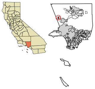
Agua Dulce is a census-designated place in Los Angeles County, California, United States. It lies at an elevation of 2,526 feet (770 m), northeast of Santa Clarita. The community had a population of 3,342 at the 2010 census and covers a geographic area of about 23 square miles (59 km2). Agua Dulce is on the Pacific Crest Trail. The ZIP code is 91390, and the area code is 661.

<span class="mw-page-title-main">Castaic, California</span> Community in Los Angeles County, United States

Castaic is an unincorporated community in the northwestern part of Los Angeles County, California, United States. As of the 2010 census it had a population of 19,015. For statistical purposes the Census Bureau has defined Castaic as a census-designated place (CDP).

<span class="mw-page-title-main">San Francisquito Canyon</span> Canyon along San Francisquito Creek in the Sierra Pelona of California, United States

San Francisquito Canyon is a canyon created through erosion of the Sierra Pelona Mountains by the San Francisquito Creek, in Los Angeles County, Southern California.

<span class="mw-page-title-main">Lake Hughes, California</span> Unincorporated community in California, United States

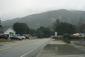
Lake Hughes is an unincorporated community in northern Los Angeles County, California. It is in the Sierra Pelona Mountains, northwest of Palmdale and north of the Santa Clarita Valley, in the Angeles National Forest. It is on the sag pond waters of Lake Hughes and Elizabeth Lake. The community is rural in character, with a population of 649 in 2010, but also has a strong recreational element centered on the three lakes in the vicinity. The community of Elizabeth Lake is located just east of Lake Hughes, sharing the same ZIP code.

<span class="mw-page-title-main">Santa Nella, California</span> Census designated place in California, United States

Santa Nella is an unincorporated village and census-designated place (CDP) in Merced County, California, United States. It is located 10 miles (16 km) west-northwest of Los Banos at an elevation of 154 feet (47 m). As of the 2020 census, Santa Nella had a population of 2,211, up from 1,380 at the 2010 census.

<span class="mw-page-title-main">Elizabeth Lake (Los Angeles County, California)</span> Intermittent lake in Elizabeth Lake, California

Elizabeth Lake is a natural sag pond that lies directly on the San Andreas Fault in the northern Sierra Pelona Mountains, in northwestern Los Angeles County, southern California.

<span class="mw-page-title-main">Sierra Pelona Ridge</span> Mountain range of the Transverse Ranges in California, United States

The Sierra Pelona, also known as the Sierra Pelona Ridge or the Sierra Pelona Mountains, is a mountain ridge in the Transverse Ranges in Southern California. Located in northwest Los Angeles County, the ridge is bordered on the north by the San Andreas fault and lies within and is surrounded by the Angeles National Forest.

<span class="mw-page-title-main">Elizabeth Lake, California</span> Census-designated place in California, United States

Elizabeth Lake is a census-designated place (CDP) and unincorporated community on Elizabeth Lake (lake), in Los Angeles County, California, United States. As of the 2010 census it had a population of 1,756.

<span class="mw-page-title-main">Butterfield Overland Mail in California</span> Historic route by state

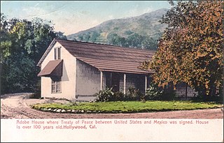
The Butterfield Overland Mail in California was created by the United States Congress on March 3, 1857, and operated until June 30, 1861. Subsequently, other stage lines operated along the Butterfield Overland Mail in route in Alta California until the Southern Pacific Railroad arrived in Yuma, Arizona in 1877.

<span class="mw-page-title-main">Hasley Canyon, California</span> Census-designated place in California, United States

Hasley Canyon is a census-designated place in the Sierra Pelona mountains of Los Angeles County, California. Hasley Canyon sits at an elevation of 1,765 feet (538 m). The 2010 United States census reported Hasley Canyon's population was 1,137.

<span class="mw-page-title-main">San Francisquito Creek (Santa Clara River tributary)</span> Tributary of the Santa Clara River in California, United States

San Francisquito Creek, in Los Angeles County, is a tributary stream of the Santa Clara River. It drains the south facing slopes of the Sierra Pelona Mountains of the San Gabriel Mountains within the Transverse Range of California, United States.

San Francisquito Pass is a mountain pass in the Sierra Pelona Mountains, located northeast of Green Valley and Santa Clarita, in northern Los Angeles County, California.

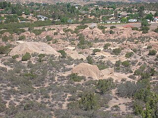
Mud Spring, formerly called Aquaje Lodoso, is a spring and historic site in the western Antelope Valley, within northern Los Angeles County, southern California.

King's Station, also known as Moore's and Hollandsville, was a stagecoach station of the Butterfield Overland Mail 1st Division between 1858 and 1861 in southern California.

Widow Smith's Station, also known as Major Gordon's Station and Clayton's Station, was a stagecoach station of the Butterfield Overland Mail 1st Division from 1858 to 1861 in southern California.

References

  1. U.S. Census Archived January 25, 2012, at the Wayback Machine
  2. 1 2 3 U.S. Geological Survey Geographic Names Information System: Green Valley, Los Angeles County, California
  3. U.S. Geological Survey Geographic Names Information System: Green Valley, Los Angeles County, California
  4. Mildred Brooke Hoover, Hero Eugene Rensch, Ethel Grace Rensch, 3rd Edition revised by William N. Abeloe, Historic Spots in California, 3rd Ed., Stanford University Press, Stanford, 1966, p.168
  5. Harris Newmark, "Sixty Years in Southern California, 1853–1913", The Knickerbocker Press, New York, 1916, p. 195
  6. List of Stations from New York Times, October 14 1858, Itinerary of the Route
  7. "U.S. Census website".
  8. "2010 Census Interactive Population Search: CA – Green Valley CDP". U.S. Census Bureau. Archived from the original on July 15, 2014. Retrieved July 12, 2014.
  9. "U.S. Census website" . Retrieved July 9, 2015.
  10. Owen, Rob (March 15, 2010). "'Justified' another worthy FX offering". Pittsburgh Post-Gazette . Archived from the original on October 21, 2012. Retrieved December 21, 2022.