Westmont, California

Last updated

Westmont, California
George Washington Preparatory High School Main Entrance.jpg
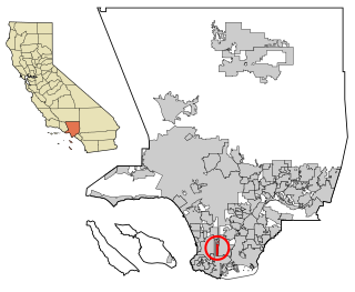
LA County Incorporated Areas Westmont highlighted.svg
Location of Westmont in
Los Angeles County, California.
Usa edcp location map.svg
Red pog.svg
Westmont, California
Location in the United States
Coordinates: 33°56′29″N118°18′8″W / 33.94139°N 118.30222°W / 33.94139; -118.30222
Country United States
State California
County Los Angeles
Area
[1]
  Total1.848 sq mi (4.785 km2)
  Land1.848 sq mi (4.785 km2)
  Water0 sq mi (0 km2)  0%
Elevation
[2]
217 ft (66 m)
Population
  Total33,913
  Density18,000/sq mi (7,100/km2)
Time zone UTC-8 (Pacific)
  Summer (DST) UTC-7 (PDT)
ZIP code
90047
Area codes 213/323 [4]
FIPS code 06-84592
GNIS feature ID 1867072

Westmont is an unincorporated community in Los Angeles County, California, a part of the South Los Angeles area, just east of Inglewood. The population was 33,913 at the 2020 census, [5] up from 31,853 at the 2010 census. For statistical purposes, the United States Census Bureau has defined Westmont as a census-designated place (CDP).

Contents

Geography

Westmont has a total area of 1.8 square miles (4.7 km2), all land. [6] It adjoins the Vermont Vista neighborhood of the city of Los Angeles.

History

In 2009, Westmont was the subject of a feature story by Hector Tobar in the Los Angeles Times who wrote that the community was "officially (but rarely) called Westmont" but that it had "no "'mont,' not even a hill. It got its name, it seems, from being west of Vermont Avenue." Tobar noted that Westmont's unemployment rate was at the time "a staggering 23.6%, the highest in Los Angeles County." [7]

Five years later, the strip of Vermont Avenue which is shared between Westmont and Vermont Vista was called "death alley" by the newspaper because during the past seven years sixty people had been killed by violence on that two-mile stretch. It remained at the highest rate of killings of any neighborhood in Los Angeles County. [8]

The 2014 article stated that "The area was long been controlled by a gang named the Underground Crips, whose members would, in more violent days, walk across Normandie Avenue to shoot at rivals." [9]

Demographics

According to the Los Angeles Times , fewer than six percent of residents held bachelor's degrees in 2000. The neighborhood is fraught with gang and police-related violence, as well as structural racism and entrenched poverty. [10]

For statistical purposes, the United States Census Bureau has designated the unincorporated area as a census designated place (CDP).

Historical population
CensusPop.Note
1970 29,310
1980 27,916−4.8%
1990 31,04411.2%
2000 31,6231.9%
2010 31,8530.7%
2020 33,9136.5%
[11]

2020

Westmont CDP, California – Racial and Ethnic Composition
(NH = Non-Hispanic)
Note: the US Census treats Hispanic/Latino as an ethnic category. This table excludes Latinos from the racial categories and assigns them to a separate category. Hispanics/Latinos may be of any race.
Race / EthnicityPop 2010 [12] Pop 2020 [13] % 2010% 2020
White alone (NH)3244271.02%1.26%
Black or African American alone (NH)15,95513,71750.09%40.45%
Native American or Alaska Native alone (NH)38590.12%0.17%
Asian alone (NH)991940.31%0.57%
Pacific Islander alone (NH)30590.09%0.17%
Some Other Race alone (NH)1482310.46%0.68%
Mixed Race/Multi-Racial (NH)3888311.22%2.45%
Hispanic or Latino (any race)14,87118,39546.69%54.24%
Total31,85333,913100.00%100.00%

2010

In the 2010 census Westmont had a population of 31,853. The population density was 17,239.9 inhabitants per square mile (6,656.4/km2). The racial makeup of Westmont was 16,262 (51.1%) African American, 5,037 (15.8%) white (including 1.0% non-Hispanic white), [14] 188 (0.6%) Native American, 126 (0.4%) Asian, 31 (0.1%) Pacific Islander, 9,180 (28.8%) from other races, and 1,029 (3.2%) from two or more races. Hispanic or Latino of any race were 14,871 persons (46.7%). [15]

The census reported that 31,693 people (99.5% of the population) lived in households, 119 (0.4%) lived in non-institutionalized group quarters, and 41 (0.1%) were institutionalized.

There were 9,695 households, 4,750 (49.0%) had children under the age of 18 living in them, 2,995 (30.9%) were opposite-sex married couples living together, 3,194 (32.9%) had a female householder with no husband present, 904 (9.3%) had a male householder with no wife present. There were 776 (8.0%) unmarried opposite-sex partnerships, and 52 (0.5%) same-sex married couples or partnerships. 2,141 households (22.1%) were one person and 669 (6.9%) had someone living alone who was 65 or older. The average household size was 3.27. There were 7,093 families (73.2% of households); the average family size was 3.78.

The age distribution was 9,860 people (31.0%) under the age of 18, 3,759 people (11.8%) aged 18 to 24, 8,577 people (26.9%) aged 25 to 44, 6,979 people (21.9%) aged 45 to 64, and 2,678 people (8.4%) who were 65 or older. The median age was 29.9 years. For every 100 females, there were 86.8 males. For every 100 females age 18 and over, there were 80.3 males.

There were 10,588 housing units at an average density of 5,730.6 per square mile, of the occupied units 3,012 (31.1%) were owner-occupied and 6,683 (68.9%) were rented. The homeowner vacancy rate was 2.5%; the rental vacancy rate was 8.8%. 10,864 people (34.1% of the population) lived in owner-occupied housing units and 20,829 people (65.4%) lived in rental housing units.

2000

In the 2000 census there were 31,623 people, 9,255 households, and 7,089 families living in the CDP. The population density was 17,103.0 inhabitants per square mile (6,603.5/km2). There were 10,186 housing units at an average density of 5,509.0 per square mile (2,127.0/km2). The racial makeup of the CDP was 11.8% White, 58.0% African American, 0.6% Native American, 0.4% Asian, 0.2% Pacific Islander, 25.8% from other races, and 3.3% from two or more races. Hispanic or Latino of any race were 39.5%. [16]

Of the 9,255 households 47.3% had children under the age of 18 living with them, 33.9% were married couples living together, 34.9% had a female householder with no husband present, and 23.4% were non-families. 19.2% of households were one person and 5.0% were one person aged 65 or older. The average household size was 3.41 and the average family size was 3.85.

The age distribution was 37.8% under the age of 18, 10.5% from 18 to 24, 29.3% from 25 to 44, 16.3% from 45 to 64, and 6.0% 65 or older. The median age was 26 years. For every 100 females, there were 86.6 males. For every 100 females age 18 and over, there were 78.5 males.

The median household income was $23,323 and the median family income was $23,712. Males had a median income of $24,682 versus $25,775 for females. The per capita income for the CDP was $9,765. About 35.3% of families and 36.9% of the population were below the poverty line, including 46.7% of those under age 18 and 22.1% of those age 65 or over.

Mexican and Unspecified African were the most common ancestries according to Mapping L.A. Mexico and El Salvador were the most common foreign places of birth. [17]

Government

In the California State Legislature, Westmont is in the 30th Senate District , represented by Democrat Bob Archuleta, and in the 62nd Assembly District , represented by Democrat Anthony Rendon. [18]

In the United States House of Representatives, Westmont is in California's 43rd congressional district , represented by Democrat Maxine Waters. [19]

Law enforcement is provided by the Los Angeles County Sheriff's Department. [20]

Education

Woodcrest School, 1151 109th Street Woodcrest School 1151 109th Street Westmont Los Angeles County 01.jpg
Woodcrest School, 1151 109th Street

The area is within the Los Angeles Unified School District. [21]

Areas considered to be in Westmont are generally zoned to:[ citation needed ]

LAUSD schools in Westmont include: [22]

Charter schools in Westmont include:

Library Service

Notable people

See also

Related Research Articles

<span class="mw-page-title-main">Alondra Park, California</span> Census designated place in California, United States

Alondra Park, also known as El Camino Village, is a census designated place (CDP) in the South Bay region of Los Angeles County, California, United States. It is the unincorporated area north of Alondra Community Regional Park and El Camino College. It is east of Lawndale, south of Hawthorne, west of Gardena, and north of Torrance. Manhattan Beach Boulevard and Crenshaw Boulevard are the two major cross streets in the area. The population was 8,569 at the 2020 census, down from 8,592 at the 2010 census. There is an official Alondra Park Post Office of the U.S. Postal Service in nearby Gardena, California. Urbanized cement-lined Dominguez Creek bisects a portion of Alondra Park.

<span class="mw-page-title-main">Avocado Heights, California</span> Census-designated place in California, United States

Avocado Heights is an unincorporated census-designated place (CDP) in the San Gabriel Valley of Los Angeles County, California, United States. It is almost entirely surrounded by the City of Industry with only a small strip of unincorporated Los Angeles County separating it from South El Monte. It is in close proximity to both the Pomona (SR-60) and San Gabriel (I-605) freeways. To the west is the San Gabriel River and the California Country Club. Avocado Heights is approximately 15 miles (24 km) from the downtown Los Angeles Civic Center. The population was 15,411 at the 2010 census, up from 15,148 at the 2000 census.

<span class="mw-page-title-main">Del Aire, California</span> Census-designated place in California, United States

Del Aire is a census-designated place (CDP) in the inland South Bay, Los Angeles County, California, United States, between El Segundo and Hawthorne. The population was 10,001 at the 2010 census, up from 9,012 at the 2000 census.

<span class="mw-page-title-main">Florence-Graham, California</span> Census-designated place in South Los Angeles, California

Florence-Graham is a census-designated place in Los Angeles County, California. The population was 61,983 at the 2020 census, down from 63,387 at the 2010 census. The census area includes separate communities of Florence, Firestone Park, and Graham. It is located in the south central region of Los Angeles County. The neighboring communities are Central-Alameda, Florence, Green Meadows, Lynwood, South Gate, South Park, Vernon, Walnut Park and Watts.

<span class="mw-page-title-main">Ladera Heights, California</span> Unincorporated community in Los Angeles County, California, US

Ladera Heights is a community and unincorporated area in Los Angeles County, California. The population was 6,634 at the 2020 census. Culver City lies to its west, the Baldwin Hills neighborhood to its north, the View Park-Windsor Hills community to its east, the Westchester neighborhood to its south and southwest and the city of Inglewood to its southeast. With an average household income of $132,824, Ladera Heights ranks third amongst the ten wealthiest Black communities in the United States.

<span class="mw-page-title-main">Lennox, California</span> Census-designated place in California, United States

Lennox is a census-designated place (CDP) in the South Bay region of Los Angeles County, California, United States. The population was 22,753 at the 2010 census, down from 22,950 at the 2000 census.

<span class="mw-page-title-main">Quartz Hill, California</span> Census-designated place in California, United States

Quartz Hill is a census-designated place (CDP) in Los Angeles County, California, United States. The population was 10,912 at the 2010 census, up from 9,890 at the 2000 census. The name is also shared with the neighboring district areas of its border cities, Palmdale, and Lancaster. Quartz Hill was once home to the Quartz Hill Airport. According to the Greater Antelope Valley Economic Alliance report of 2009, the Palmdale / Lancaster urban area of which Quartz Hill is a part, has a population of 483,998.
<span class="mw-page-title-main">South San Gabriel, California</span> Census-designated place in California, United States

South San Gabriel is a census-designated place (CDP) in Los Angeles County, California, United States. The population was 8,070 at the 2010 census, up from 7,595 at the 2000 census.
<span class="mw-page-title-main">Valinda, California</span> Census-designated place in California, United States

Valinda is a census-designated place (CDP) in the San Gabriel Valley, in Los Angeles County, California, in the United States. At the 2010 census, the population was 22,822, up from 21,776 at the 2000 census.
<span class="mw-page-title-main">View Park–Windsor Hills, California</span> Unincorporated community in California, United States

View Park−Windsor Hills is an unincorporated community in Los Angeles County, California. The View Park neighborhood is the community surrounding Angeles Vista Boulevard and the Windsor Hills neighborhood is on the southern end to the north of Slauson Avenue.

<span class="mw-page-title-main">Vincent, California</span> Census-designated place in California, United States

Vincent is a census-designated place (CDP) in the central San Gabriel Valley, in Los Angeles County, California, United States. The city name and zipcode for addresses south of Arrow Highway is Covina and 91722, respectively, and Azusa and 91702 for addresses north of Arrow Highway. The population was 15,922 at the 2010 census, up from 15,097 at the 2000 census. Vincent is named after Vincent Avenue, which passes through the community.

<span class="mw-page-title-main">Walnut Park, California</span> Census-designated place in California, United States

Walnut Park is a census-designated place (CDP) in Los Angeles County, California, United States, adjacent to Florence-Graham, Huntington Park and South Gate. The population was 15,966 at the 2010 census, down from 16,180 at the 2000 census.

<span class="mw-page-title-main">West Athens, California</span> Unincorporated community in California, United States

West Athens is a census-designated place (CDP) in Los Angeles County, California. The population was 9,393 at the 2020 census. It is an unincorporated community within the 2nd Supervisorial District of Los Angeles County. West Athens is served by the Los Angeles County Sheriff's Department, operating out of the South Los Angeles Station. The approximate boundaries for West Athens are: 87th Street to the north, Vermont Avenue to the east, El Segundo Boulevard to the south, and approximately Western Avenue to Van Ness Avenue to the west. West Athens is predominantly residential, with commercial uses along its main corridors. Los Angeles Southwest Community College lies within the West Athens neighborhood and city limits.
<span class="mw-page-title-main">West Carson, California</span> Unincorporated community in California, United States

West Carson is an unincorporated community in the South Bay region of Los Angeles County, California. The population was 22,870 at the 2020 census. For statistical purposes, the United States Census Bureau has defined West Carson as a census-designated place (CDP).

<span class="mw-page-title-main">West Rancho Dominguez, California</span> Unincorporated community in California, United States

West Rancho Dominguez, formerly known as West Compton and also known as East Gardena, is an unincorporated census-designated place (CDP) located in southern Los Angeles County, California. Per the 2020 census, the population was 24,347. The community lies to the west of the city of Compton. The ZIP Codes encompassing the CDP area are 90220 & 90248.

<span class="mw-page-title-main">West Whittier-Los Nietos, California</span> Census-designated place in California, United States

West Whittier-Los Nietos is a census-designated place (CDP) in Los Angeles County, California, near the San Gabriel River and the San Gabriel River (I-605) Freeway. The population was 25,540 at the 2010 census, up from 25,129 at the 2000 census. The census area consists of separate unincorporated communities of Los Nietos and West Whittier.

<span class="mw-page-title-main">Woodcrest, California</span> Census-designated place in California, United States

Woodcrest is a census-designated place (CDP) in Riverside County, California, United States. The population was 14,347 at the 2010 census, up from 8,342 at the 2000 United States Census. The adjacent city of Riverside lists Woodcrest as an area for potential annexation.

<span class="mw-page-title-main">Chino, California</span> City in California, United States

Chino is a city in the western end of San Bernardino County, California, United States, with Los Angeles County to its west and Orange County to its south in the Southern California region. Chino is adjacent to the more affluent Chino Hills. Chino's surroundings have long been a center of agriculture and dairy farming, providing milk products in Southern California and much of the southwestern United States. Chino's agricultural history dates back to the Spanish land grant forming Rancho Santa Ana del Chino. The area specialized in fruit orchards, row crops, and dairy.

<span class="mw-page-title-main">Ánimo South Los Angeles Charter High School</span> High school in California, USA

Ánimo South Los Angeles Charter High School is a public charter school operated by Green Dot Public Schools of Los Angeles.

Rose Hills is a census-designated place in Los Angeles County, California. Rose Hills sits at an elevation of 518 feet (158 m) above sea level. The 2010 United States census reported Rose Hills's population was 2,803.

References

  1. "2010 Census U.S. Gazetteer Files – Places – California". United States Census Bureau.
  2. "Westmont". Geographic Names Information System . United States Geological Survey, United States Department of the Interior . Retrieved March 25, 2015.
  3. "Westmont CDP QuickFacts". United States Census Bureau . Retrieved August 18, 2021.
  4. "Planning Letter PL-494 NPA 213 and 323 Boundary Elimination Overlay (California)" (PDF). North American Numbering Plan Administration. August 9, 2016. p. 6. Retrieved June 13, 2020.
  5. "Westmont CDP QuickFacts". United States Census Bureau . Retrieved August 18, 2021.
  6. "US Gazetteer files: 2010, 2000, and 1990". United States Census Bureau. February 12, 2011. Retrieved April 23, 2011.
  7. "Hope Endures in Hard Times," Los Angeles Times, September 15, 2009, image 2
  8. Nicole Santa Cruz and Ken Schwencke, "Tiny Westmont Has L.A. County's Top Homicide Rate," Los Angeles Times, January 19, 2014, image 1 (with map of the area)
  9. "Westmont's Tide of Violence," Los Angeles Times, January 19, 2014, image 18
  10. Nicole Santa Cruz; Ruben Vives (September 5, 2020). "'A forgotten city': An L.A. community beset by police violence and crime hopes for change". L.A. Times.
  11. "Historical Population Data for California". Archived from the original on March 11, 2007. Retrieved March 11, 2007.
  12. "P2 HISPANIC OR LATINO, AND NOT HISPANIC OR LATINO BY RACE – 2010: DEC Redistricting Data (PL 94-171) – Westmont CDP, California". United States Census Bureau .
  13. "P2 HISPANIC OR LATINO, AND NOT HISPANIC OR LATINO BY RACE - 2020: DEC Redistricting Data (PL 94-171) - Westmont CDP, California". United States Census Bureau .
  14. "Census data". quickfacts.census.gov.
  15. "2010 Census Interactive Population Search: CA – Westmont CDP". U.S. Census Bureau. Archived from the original on July 15, 2014. Retrieved July 12, 2014.
  16. "U.S. Census website". United States Census Bureau . Retrieved January 31, 2008.
  17. "Westmont Profile - Mapping L.A. - Los Angeles Times". Los Angeles Times.
  18. "Statewide Database". UC Regents. Archived from the original on February 1, 2015. Retrieved December 7, 2014.
  19. "California's 43rd Congressional District - Representatives & District Map". Civic Impulse, LLC.
  20. Santa Cruz, Nicole; Vives, Ruben (September 5, 2020). "'A forgotten city': An L.A. community beset by police violence and crime hopes for change". Los Angeles Times. Retrieved September 6, 2020.
  21. "2020 CENSUS - SCHOOL DISTRICT REFERENCE MAP: Los Angeles County, CA" (PDF). U.S. Census Bureau. p. 10 (PDF p. 11/19). Retrieved November 19, 2023.
  22. "2020 CENSUS - CENSUS BLOCK MAP: Westmont CDP, CA" (PDF). U.S. Census Bureau . Retrieved November 19, 2023. - Compare with school addresses
  23. "Home". Boys Academic Leadership Academy. Retrieved November 19, 2023. 1511 W 110th St Los Angeles, CA 90047 - Compare to the census map
    Note: Note that the City of Houston had stated: "The U.S. Postal Service establishes ZIP codes and mailing addresses in order to maximize the efficiency of their system, not to recognize jurisdictional boundaries."
  24. "Home". George Washington Preparatory High School . Retrieved November 19, 2023. 10860 S Denker Ave Los Angeles, CA 90047 - Compare address to the census map.
  25. "Home". Duke Ellington Continuation High School. Retrieved November 19, 2023. 1541 W 110th St Los Angeles, CA 90047 - Compare address to the census map.
  26. "Home". Woodcrest Elementary School. Retrieved November 19, 2023. 1151 W 109th St Los Angeles, CA 90044 - Compare address to the census map.
  27. "Home". 95th Street Elementary School. Retrieved November 19, 2023. 1109 W 96th St Los Angeles, CA 90044 - Compare address to the census map.
  28. "Home". Animo South Los Angeles Charter High School . Retrieved November 19, 2023. 11130 S. Western Avenue Los Angeles, CA 90047
  29. "Woodcrest Library". County of Los Angeles Public Library . Retrieved November 19, 2023. 1340 W 106th St, Los Angeles, CA 90044 - Compare to the census map
    Note: Note that the City of Houston had stated: "The U.S. Postal Service establishes ZIP codes and mailing addresses in order to maximize the efficiency of their system, not to recognize jurisdictional boundaries."
  30. Sunday William, "Ice Cube's Net Worth in 2020:Early Life," Kingged.com, January 9, 2020