San Pedro Bay (California)

Last updated

San Pedro Bay in a 1900 plan for the Los Angeles Harbor, present cities and districts are named LA-Harbor-plan-1900.gif
San Pedro Bay in a 1900 plan for the Los Angeles Harbor, present cities and districts are named

San Pedro Bay is an inlet on the Pacific Ocean coast of southern California, United States. It is the site of the Port of Los Angeles and the Port of Long Beach, which together form the fifth-busiest port facility in the world (behind the ports of Shanghai, Singapore, Hong Kong, and Shenzhen) and the busiest in the Americas. The Los Angeles community of San Pedro borders a small portion of the western side of the bay. [1] [2] [3] The city of Long Beach borders the port on the eastern side of the bay. The northern part of the bay, which is the largest part of the port, is bordered by the Los Angeles neighborhood of Wilmington. [4]

Contents

Seabed

Most of the bay is between 32 and 75 feet (10 and 23 m) deep. The seabed near Long Beach has experienced considerable subsidence as a result of oil extraction in the Wilmington Field from the 1950s onward. This helped the Port of Long Beach surpass the Port of Los Angeles as the leading port in the United States for a time in the 1980s and 1990s, since the deeper seafloor meant that Long Beach could accommodate ships with deeper drafts than could Los Angeles. Dredging operations related to the construction of a gigantic new marine terminal at the Port of Los Angeles have since made both sides of the bay accessible to even the largest existing container ships. Concerns regarding subsidence increased until Operation "Big Squirt", a water injection program, halted any progression of sinking land in 1960. [5]

Islands

Natural islands in San Pedro Bay include Terminal Island (actually an augmented mudflat and Rattlesnake Island), [6] the site of much of Los Angeles' and Long Beach's port facilities, Mormon Island, the site of an abortive settlement attempt by San Bernardino-based Mormon pioneers in the 1850s, and Smith's Island. [7] Land reclamation operations by Los Angeles have considerably enlarged Terminal Island, as well as linking Mormon Island to the mainland. Deadman's Island sat at a landmark at the foot of the bay, but was removed in 1928 as part of the effort by Phineas Banning to enlarge the harbor. In 1927 an airport, originally called Allen Field and later Naval Air Station Terminal Island, was built on San Pedro's Terminal Island. [8] [9] [10]

Four small artificial islands containing oil wells (the THUMS Islands) are scattered around the bay near Long Beach. The oil drilling equipment itself is masked by tropical landscaping, architectural features and fake high-rise "buildings" in an attempt to improve their appearance from shore. These islands, named Oil Islands Freeman, Grissom, White, and Chaffee, are named for Theodore Freeman, the first NASA astronaut to die during flight, and for Gus Grissom, Ed White, and Roger B. Chaffee, who were killed by a fire during the Apollo 1 mission. [11]

Free Harbor Fight

Los Angeles Harbor Light Angels Gate - San Pedro, Los Angeles, California panoramio.jpg
Los Angeles Harbor Light

As Los Angeles developed as an economic and trading hub, the need for a deep harbor became apparent. In the late 1890s, the Southern Pacific Railroad started purchasing large parcels of land in Santa Monica near its terminus, and the Huntington family advocated for a Santa Monica harbor, which would have monopolized Southern Pacific freight. In opposition, the Los Angeles Chamber of Commerce and a newly formed Harbor League advocated for a harbor to be built in San Pedro, where the Southern Pacific would have competition with Phineas Banning's Los Angeles and Harbor Railroad. The resulting Free Harbor Fight and 1906 annexation of the Harbor Gateway ensured Wilmington and San Pedro would serve as the main port of Los Angeles. It also explains the considerable distance between the harbor and the city's main rail yards, a situation not addressed until the construction of the Alameda Corridor nearly a century later. [12]

Breakwaters

Three breakwaters extend 8.5 miles (13.7 km) across most of the bay, with two openings to allow ships to enter the Port of Los Angeles and the Port of Long Beach. The first section of the San Pedro Breakwater was constructed between 1899 and 1911 at San Pedro. The Rivers and Harbors Act of 1930 authorized further construction. [13] The middle breakwater began construction in 1932. [13] The 2.5-mile eastern breakwater, also known as the Long Beach Breakwater, was constructed between 1941 and 1949. [13] [14]

Building one of the breakwaters, 1937 Long Beach - Los Angeles Harbor Breakwater - Contract W-509-Eng.-103 - Rohl-Connolly Co. - Vol. VII No. 29 - These... - NARA - 295343.jpg
Building one of the breakwaters, 1937

The western and middle breakwaters provided the ports considerable protection in the 1939 California tropical storm. With the eastern breakwater not yet constructed, coastal neighborhoods of Long Beach such as Belmont Shore were severely impacted. [15]

Waves at Long Beach, 1906 Long Beach from across the surf, showing the Hotel Bixby under construction in the distance at right, ca.1906 (CHS-2803).jpg
Waves at Long Beach, 1906

Restoration

The Long Beach breakwater is the target of controversy within the harbor towns and Greater Los Angeles conservationist community, with various environmental groups, including the Long Beach chapter of the Surfrider Foundation, proposing modifying or removing the breakwater to promote better water flows and a more natural coastal environment at the mouth of the Los Angeles River. This restoration ecology-based removal is opposed by waterfront property owners and shippers, who consider that the breakwater provides needed protection from storm damage. [16] [17]

A short documentary addressing the issues surrounding the reconfiguration of the Long Beach breakwater is available. [18]

See also

Related Research Articles

<span class="mw-page-title-main">South Bay (Los Angeles County)</span> Region in California, United States

The South Bay is a region of the Los Angeles metropolitan area, located in the southwest corner of Los Angeles County. The name stems from its geographic location stretching along the southern shore of Santa Monica Bay. The South Bay contains sixteen cities plus portions of the City of Los Angeles and unincorporated portions of the county. The area is bounded by the Pacific Ocean on the south and west and generally by the City of Los Angeles on the north and east.

<span class="mw-page-title-main">San Pedro, Los Angeles</span> Neighborhood of Los Angeles in California, United States

San Pedro is a neighborhood located within the South Bay and Harbor region of the City of Los Angeles, California, United States. Formerly a separate city, it consolidated with Los Angeles in 1909. The Port of Los Angeles, a major international seaport, is partially located within San Pedro. The district has grown from being dominated by the fishing industry, to a working-class community within the city of Los Angeles, to an increasingly dense community.

<span class="mw-page-title-main">Wilmington, Los Angeles</span> Neighborhood of Los Angeles in Los Angeles, California

Wilmington is a neighborhood in the South Bay and Harbor region of Los Angeles, California, covering 9.14 square miles (23.7 km2).

<span class="mw-page-title-main">Port of Los Angeles</span> Harbor in Los Angeles, California

The Port of Los Angeles is a seaport managed by the Los Angeles Harbor Department, a unit of the City of Los Angeles. It occupies 7,500 acres (3,000 ha) of land and water with 43 miles (69 km) of waterfront and adjoins the separate Port of Long Beach. Promoted as "America's Port", the port is located in San Pedro Bay in the San Pedro and Wilmington neighborhoods of Los Angeles, approximately 20 miles (32 km) south of downtown.

<span class="mw-page-title-main">Terminal Island</span> Island in Los Angeles County, California, United States

Terminal Island, historically known as Isla Raza de Buena Gente, is a largely artificial island located in Los Angeles County, California, between the neighborhoods of Wilmington and San Pedro in the city of Los Angeles, and the city of Long Beach. Terminal Island is roughly split between the Port of Los Angeles and Port of Long Beach. Land use on the island is entirely industrial and port-related except for Federal Correctional Institution, Terminal Island.

<span class="mw-page-title-main">Wilmington Oil Field</span> Petroleum field in Los Angeles County, California, United States

The Wilmington Oil Field is a prolific petroleum field in Los Angeles County in southern California in the United States. Discovered in 1932, it is the third largest oil field in the United States in terms of cumulative oil production. The field runs roughly southeast to northwest through the Los Angeles Basin, stretching from the middle of San Pedro Bay through Long Beach and east of the Palos Verdes Peninsula. The field originally contained approximately 3 billion barrels (480,000,000 m3) of reserves. In 2013, the USGS estimated future potential production from the combined Wilmington-Belmont oilfield could be around 900 million barrels (140,000,000 m3).

The Free Harbor Fight refers to the legal battle in the late nineteenth century on the West Coast of the United States, around Los Angeles Area Chamber of Commerce against Huntington and the Southern Pacific. US Senator Stephen M. White failed to cave in to the pressure of the railroad baron Collis Huntington and his congressional allies, which resulted in the Port of Los Angeles being located in San Pedro, instead of Santa Monica, as Huntington had wanted.

<span class="mw-page-title-main">Phineas Banning</span> American businessman (1830–1885)

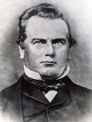
Phineas Banning was an American businessman, financier and entrepreneur.

<span class="mw-page-title-main">Port of Long Beach</span> Container port near Los Angeles, California

The Port of Long Beach, administered as the Harbor Department of the City of Long Beach, is a container port in the United States, which adjoins Port of Los Angeles. Acting as a major gateway for US–Asian trade, the port occupies 3,200 acres (13 km2) of land with 25 miles (40 km) of waterfront in the city of Long Beach, California. The Port of Long Beach is located less than two miles (3 km) southwest of Downtown Long Beach and approximately 25 miles (40 km) south of Downtown Los Angeles. The seaport generates approximately US$100 billion per year in trade and employs more than 316,000 people in Southern California. In 2022, the port, together with the adjoining Port of Los Angeles, were considered amongst the world's least efficient ports by the World Bank and IHS Markit citing union protectionism and a lack of automation.

<span class="mw-page-title-main">Harbor Subdivision</span> BNSF right of way in Los Angeles

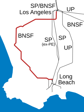
The Harbor Subdivision is a single-track main line of the BNSF Railway which stretches 26 miles (42 km) between rail yards near downtown Los Angeles and the ports of Los Angeles and Long Beach across southwestern Los Angeles County. It was the primary link between two of the world's busiest harbors and the national rail network. Mostly displaced with the April 15, 2002 opening of the more direct Alameda Corridor, the Harbor Sub takes a far more circuitous route from origin to destination, owing to its growth in segments over the decades. The subdivision was built in this fashion beginning in the early 1880s to serve the ports and the various businesses that developed along it.

<span class="mw-page-title-main">California State Route 47</span> Highway in California

State Route 47 is a state highway in the U.S. state of California, connecting Terminal Island to the mainland in the Los Angeles area. From its south end at I-110 in San Pedro, it heads east across the Vincent Thomas Bridge to the island and the end of state maintenance. The state highway begins again at the junction with I-710 on Terminal Island, crossing the Schuyler Heim Bridge north to the mainland and the second terminus, where SR 103 begins. Signage continues along a locally maintained route, mainly Alameda Street, to the Gardena Freeway in Compton, and an unconstructed alignment follows the same corridor to the Santa Monica Freeway (I-10) near downtown Los Angeles.

<span class="mw-page-title-main">Commodore Schuyler F. Heim Bridge</span> Bridge in Wilmington, California

The Commodore Schuyler F. Heim Bridge was a vertical-lift bridge in the Port of Los Angeles. Dedicated on January 10, 1948, the bridge allowed State Route 47 to cross over the Cerritos Channel. Named after Schuyler F. Heim, who was in command of the Naval Air Station on Terminal Island in 1942, the bridge was one of the largest vertical-lift bridges on the West Coast. At the time of its opening, it was the highest in the country with the deck weighing about 820 short tons. Its towers are 186 feet (57 m) tall above the roadway deck and about 236 feet (72 m) tall when measured from the water level at high water. The bridge was decommissioned on October 12, 2015 and replaced by a new, six-lane fixed-span bridge in order to meet current safety and earthquake standards. A replacement bridge, tentatively titled State Route 47 Schuyler Heim Bridge Replacement, was completed in September 2020.

<span class="mw-page-title-main">Cabrillo Beach</span>

Cabrillo Beach is a historic public beach located in San Pedro, Los Angeles, California. It is named after Juan Rodríguez Cabrillo, a Spanish explorer who was the first to sail up the California coast. Cabrillo has two separate beach areas.

<span class="mw-page-title-main">Harbor City, Los Angeles</span> Neighborhood of Los Angeles in California, United States

Harbor City is a highly diverse neighborhood in the South Bay and Harbor region of Los Angeles, California, with a population upward of 36,000 people. Originally part of the Rancho San Pedro Spanish land grant, the 2.58-square-mile (6.7 km2) Harbor City was brought into Los Angeles as a preliminary step in the larger city's consolidation with the port cities of Wilmington and San Pedro.

<span class="mw-page-title-main">THUMS Islands</span> Set of four artificial islands in San Pedro Bay off the coast of Long Beach, California

The THUMS Islands are a set of four artificial islands in San Pedro Bay off the coast of Long Beach, California. The THUMS Islands were built in 1965 to tap into the East Wilmington Oil Field. The landscaping and sound walls were designed to camouflage the operation and reduce noise, and they are the only decorated oil islands in the United States. The islands were named for the company who bid for original operating contract, THUMS, a consortium named after its parent companies: Texaco, Humble, Unocal, Mobil, and Shell.

<span class="mw-page-title-main">Los Angeles Harbor Region</span> Region of Los Angeles County, California, United States

The Los Angeles Harbor Region is in Los Angeles County, California. The area is impacted by the harbor complex consisting of the Port of Los Angeles and the Port of Long Beach.

<span class="mw-page-title-main">Long Wharf (Santa Monica)</span> California historical landmark

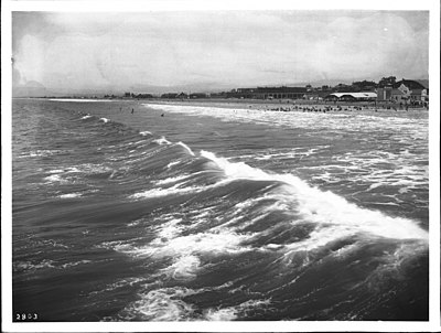
The Long Wharf in Santa Monica, also known as Port Los Angeles or the Mile Long Pier, was an extensive pier wharf constructed by the Southern Pacific Railroad Company in Santa Monica Bay from 1892 to 1894. When it opened in 1894, it was the longest wharf in the world, measuring approximately 4,700 feet (1,400 m). It served as a cargo and passenger port until 1913, and in 1919 removal of the wharf started. The wharf, the 1,000 foot (300 m) tip of the pier, was removed by 1920. The remaining 3,600 feet (1,100 m) of pier was used as a run down fishing pier until 1933, when the remainder of the pier was removed. One of the major imports to the wharf was lumber from Northern ports, to help in the construction boom in Southern California. Southern Pacific Railroad and the street cars of the Los Angeles Pacific Railroad served the wharf. Los Angeles Pacific Railroad ran passenger trams to the wharf and from midnight to sunrise ran cargo cars.

<span class="mw-page-title-main">Los Angeles & San Pedro Railroad</span> Railway line in California, US

The Los Angeles & San Pedro Railroad was Southern California's first railroad. Its 21-mile (34 km) line from San Pedro Bay to Los Angeles was built from 1868 to 1869 and began operations on October 26, 1869. The railroad was the brainchild of Phineas Banning and its primary purpose was to transport freight from the port to the city.

<span class="mw-page-title-main">Naval Operating Base Terminal Island</span> World War II Naval Base in Los Angeles

Naval Operating Base Terminal Island, was United States Navy base founded on 25 September 1941 to support the World War II efforts in the Pacific War. Naval Operating Base Terminal Island was founded by combining Naval Facilities in cities of San Pedro, Long Beach and Wilmington, California under one command. Much of the base was on the man-made Terminal Island, and harbor in San Pedro Bay. The harbor was made through the construction of a large breakwater system.

<span class="mw-page-title-main">Naval Base San Pedro</span> World War II Naval Base in Los Angeles

Naval Base San Pedro and San Pedro Submarine Base were United States Navy bases at the Port of San Pedro, California officially founded in 1919. While commissioned in 1919, the Navy started operating out of the port in 1910, by renting dock space at the City of San Pedro's Dock No. 1 in 1914. The Navy had vessels stationed at the port starting in 1913. The San Pedro Submarine Base closed in 1923, with the end of World War I. Naval Base San Pedro became part of Naval Operating Base Terminal Island on 25 September 1941, which closed in 1947.

References

  1. "Why Did a 1542 Spanish Voyage Refer to San Pedro Bay as the 'Bay of the Smoke'?" by Nathan Masters, March 28, 2013
  2. sanpedrobayhistoricalsociety.com
  3. waterandpower.org, Early Views of San Pedro and Wilmington
  4. "Map | Wilmington Neighborhood Council" . Retrieved September 11, 2020.
  5. White, Michael D. The Port of Long Beach, p. 89.
  6. "Water and Power Associates". waterandpower.org. Retrieved September 11, 2020.
  7. Gnerre, Sam (November 5, 2018). "South Bay History: The Islands of L.A. Harbor – Smith's Island and Mormon Island". Daily Breeze.
  8. Laura Pulido; Laura Barraclough; Wendy Cheng (March 24, 2012). A People's Guide to Los Angeles. University of California Press. p. 250. ISBN   978-0-520-95334-5 . Retrieved August 16, 2012.
  9. Mark Denger. "Historic California Posts: Naval Air Station, Terminal Island" . Retrieved August 16, 2012.
  10. "LA Port Plan Makes Terminal Island Preservation a Key Goal". National Trust for Historic Preservation . Retrieved January 19, 2014.
  11. Tetsuden Kashima (1997). Personal Justice Denied: Report of the Commission on Wartime Relocation and Internment of Civilians. University of Washington Press. p. 108. ISBN   978-0-295-97558-0 . Retrieved August 16, 2012.
  12. portoflosangeles.org, Cabrillo's Legacy, History
  13. 1 2 3 "Port of Long Beach History Timeline". polb.com.
  14. gazettes.com, "Port History: From Swamp to International Trade Hub", by Jonathan Van Dyke, Staff Writer, June 22, 2011
  15. Grobaty, Tim (September 25, 2019). "The Lash of St. Francis whipped the shores of Long Beach 80 years ago". Long Beach Post News.
  16. Scauzillo, Steve "Making waves: Can a change in the breakwater bring back surf to Long Beach?" Long Beach Press Telegram Environment. 25 August 2013
  17. City of Long Beach "Breakwater Reconnaissance Study" webpage accessed 22 November 2013
  18. "Mother Wants Her Beauty Back"

Further reading

33°44′00″N118°12′03″W / 33.73333°N 118.20083°W / 33.73333; -118.20083