La Palma, California | |
---|---|
Motto(s): "Where Tradition and Vision Come Together" [1] | |
Coordinates: 33°50′58″N118°2′38″W / 33.84944°N 118.04389°W | |
Country | United States |
State | California |
County | Orange |
Incorporated | October 26, 1955 [2] |
Government | |
• Type | Council-Manager |
• Mayor | Marshall Goodman |
• Mayor Pro Tem | Mark I. Waldman |
• City Council [3] | Debbie S. Baker Janet Keo Conklin Nitesh P. Patel |
• City Manager | Conal McNamara [4] |
Area | |
• Total | 1.80 sq mi (4.67 km2) |
• Land | 1.78 sq mi (4.61 km2) |
• Water | 0.02 sq mi (0.06 km2) 1.32% |
Elevation | 46 ft (14 m) |
Population (2020) | |
• Total | 15,581 |
• Density | 8,753.7/sq mi (3,379.83/km2) |
Time zone | UTC-8 (PST) |
• Summer (DST) | UTC-7 (PDT) |
ZIP code | 90623 |
Area code | 562/714/657 |
FIPS code | 06-40256 |
GNIS feature ID | 1652737 |
Website | cityoflapalma.org |
La Palma (Spanish for "The Palm") is a city in Orange County, California, United States. The population was 15,568 at the 2010 Census, [6] up from 15,408 at the 2000 census. [7]
La Palma was incorporated on October 26, 1955. It was originally incorporated as Dairyland, and was one of three dairy cities in the region (the other two being Dairy Valley, now Cerritos, and Dairy City, now Cypress) but when the dairies moved east in 1965, the name of the community was changed to La Palma, after the region's Spanish heritage and its main thoroughfare, La Palma Avenue. [8]
According to the United States Census Bureau, the city has a total area of 1.83 square miles (4.7 km2). 1.8 square miles (4.7 km2) of it is land and 0.02 square miles (0.052 km2) of it (1.32%) is water. This makes it the smallest city in Orange County in terms of area.
Census | Pop. | Note | %± |
---|---|---|---|
1960 | 622 | — | |
1970 | 9,687 | 1,457.4% | |
1980 | 15,399 | 59.0% | |
1990 | 15,392 | 0.0% | |
2000 | 15,408 | 0.1% | |
2010 | 15,568 | 1.0% | |
2019 (est.) | 15,428 | [9] | −0.9% |
U.S. Decennial Census [10] |
The 2010 US Census [6] reported that La Palma had a population of 15,568. The population density was 8,499.1 inhabitants per square mile (3,281.5/km2). The racial makeup of La Palma was 5,762 (37.0%) White (27.8% Non-Hispanic White), [11] 802 (5.2%) African American, 56 (0.4%) Native American, 7,483 (48.1%) Asian, 41 (0.3%) Pacific Islander, 760 (4.9%) from other races, and 664 (4.3%) from two or more races. Hispanic or Latino of any race were 2,487 persons (16.0%).
The census reported that 15,548 people (99.9% of the population) lived in households, 14 (0.1%) lived in non-institutionalized group quarters, and 6 (0%) were institutionalized.
There were 5,080 households, 1,949 (38.4%) had children under the age of 18 living in them, 3,331 (65.6%) were opposite-sex married couples living together, 641 (12.6%) had a female householder with no husband present, 240 (4.7%) had a male householder with no wife present. There were 134 (2.6%) unmarried opposite-sex partnerships, and 26 (0.5%) same-sex married couples or partnerships. 716 households (14.1%) were one person and 389 (7.7%) had someone living alone who was 65 or older. The average household size was 3.06. There were 4,212 families (82.9% of households); the average family size was 3.37.
The age distribution was 3,423 people (22.0%) under the age of 18, 1,418 people (9.1%) aged 18 to 24, 3,805 people (24.4%) aged 25 to 44, 4,445 people (28.6%) aged 45 to 64, and 2,477 people (15.9%) who were 65 or older. The median age was 41.2 years. For every 100 females, there were 93.5 males. For every 100 females age 18 and over, there were 90.7 males.
There were 5,224 housing units at an average density of 2,852.0 per square mile, of the occupied units 3,648 (71.8%) were owner-occupied and 1,432 (28.2%) were rented. The homeowner vacancy rate was 0.3%; the rental vacancy rate was 6.0%. 11,315 people (72.7% of the population) lived in owner-occupied housing units and 4,233 people (27.2%) lived in rental housing units.
According to the 2010 United States Census, La Palma had a median household income of $87,289, with 7.2% of the population living below the federal poverty line. [11]
At the 2000 census there were 15,408 people in 4,979 households, including 4,227 families, in the city. The population density was 8,499.3 inhabitants per square mile (3,281.6/km2). There were 5,066 housing units at an average density of 2,794.5 per square mile (1,079.0/km2). The racial makeup of the city was 44.6% Asian, 36.3% White, 10.3% Hispanic, 4.5% Black, .3% Pacific Islander, .2% Native American, .2% from other races, and 3.5% from two or more races. [12] Of the 4,979 households 37.3% had children under the age of 18 living with them, 69.5% were married couples living together, 10.8% had a female householder with no husband present, and 15.1% were non-families. 11.6% of households were one person and 3.6% were one person aged 65 or older. The average household size was 3.09 and the average family size was 3.35.
The age distribution was 23.8% under the age of 18, 8.7% from 18 to 24, 29.0% from 25 to 44, 28.3% from 45 to 64, and 10.2% 65 or older. The median age was 38 years. For every 100 females, there were 95.5 males. For every 100 females age 18 and over, there were 93.3 males.
The median household income was $68,438 and the median family income was $74,524. Males had a median income of $50,988 versus $36,242 for females. The per capita income for the city was $26,598. About 4.0% of families and 4.9% of the population were below the poverty line, including 6.0% of those under age 18 and 2.8% of those age 65 or over.
According to La Palma's 2010 Comprehensive Annual Financial Report, [13] the top employers in the city were:
# | Employer | # of Employees |
---|---|---|
1 | ADP | 600 |
2 | La Palma Intercommunity Hospital | 480 |
3 | BP West Coast Products | 300 |
4 | Unisource Worldwide | 300 |
5 | Anaheim Union High School District | 205 |
6 | Performance Machine | 205 |
7 | Kellogg's | 200 |
8 | Arcadia | 150 |
9 | Honeywell | 100 |
10 | C & D Zodiac | 80 |
According to the California Secretary of State, as of February 10, 2019, La Palma has 8,358 registered voters. Of those, 2,998 (35.87%) are registered Democrats, 2,637 (31.55%) are registered Republicans, and 2,446 (29.27%) have declined to state a political party/are independents. [14]
In the United States House of Representatives, La Palma is in California's 45th congressional district , represented by Republican Michelle Steel. [15]
Fire protection in La Palma is provided by the Orange County Fire Authority with ambulance transport by Care Ambulance Service. The La Palma Police Department provides law enforcement services.
Pettis County is a county located in west central U.S. state of Missouri. As of the 2020 census, the population was 42,980. Its county seat is Sedalia. The county was organized on January 24, 1833, and named after former U.S. Representative Spencer Darwin Pettis.
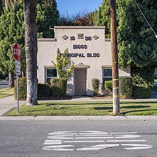
Biggs is a city in Butte County, California, United States. The population was 1,707 at the 2010 census, down from 1,793 at the 2000 census. The 2018 population estimate is 1,724.
Hamilton City is a census-designated place (CDP) in Glenn County, California, United States. The population was 1,759 at the 2010 census, down from 1,903 at the 2000 census. Hamilton City is located 9.5 miles (15 km) east of Orland, and 10 miles west of Chico at an elevation of 151 feet. The community is inside area code 530. The default prefix used for wired telephones in the Hamilton City area is 826. The postal ZIP Code is 95951.
Alondra Park, also known as El Camino Village, is a census designated place (CDP) in the South Bay region of Los Angeles County, California, United States. It is the unincorporated area north of Alondra Community Regional Park and El Camino College. It is east of Lawndale, south of Hawthorne, west of Gardena, and north of Torrance. Manhattan Beach Boulevard and Crenshaw Boulevard are the two major cross streets in the area. The population was 8,569 at the 2020 census, down from 8,592 at the 2010 census. There is an official Alondra Park Post Office of the U.S. Postal Service in nearby Gardena, California. Urbanized cement-lined Dominguez Creek bisects a portion of Alondra Park.
Hawaiian Gardens is a city in Los Angeles County, California, United States. It is the smallest city in the county in area and was incorporated on April 9, 1964. The population was 14,149 at the 2020 census, down slightly from 14,254 at the 2010 census.
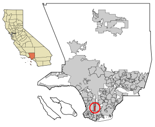
La Habra Heights is a city in Los Angeles County, California, United States. The population was 5,325 at the 2010 census, down from 5,712 at the 2000 census. La Habra Heights is a suburban canyon community located on the border of Orange and Los Angeles counties. The zoning is 1-acre (4,000 m2) lots with a variety of home and ranch style properties. La Habra Heights features open space and there are no sidewalks in the community. La Habra Heights has no commercial activity with few exception. Hacienda Park is the main park in the city and runs along Hacienda Road.
Paramount is a city in Los Angeles County, California, United States. According to the 2010 census, the city had a total population of 54,098, down from 55,266 at the 2000 census. Paramount is part of the Greater Los Angeles Area and is bordered by Compton and Lynwood to the west, South Gate and Downey to the north, Bellflower to the east and south, and Long Beach to the south.
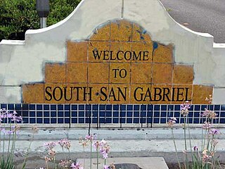
South San Gabriel is a census-designated place (CDP) in Los Angeles County, California, United States. The population was 8,070 at the 2010 census, up from 7,595 at the 2000 census.
West Carson is an unincorporated community in the South Bay region of Los Angeles County, California. The population was 22,870 at the 2020 census. For statistical purposes, the United States Census Bureau has defined West Carson as a census-designated place (CDP).
Tamalpais-Homestead Valley is a census-designated place (CDP) in Marin County, California, United States. The population was 11,492 at the 2020 census.
Boronda is an unincorporated community and census-designated place (CDP) in Monterey County, California, United States. The population was 1,760 at the 2020 census. Boronda is located directly west of Salinas and is named after José Eusebio Boronda, a Californio ranchero, and located on the lands of his Rancho Rincón del Sanjón.
Cypress is a city in northwestern Orange County within Southern California. Its population was 50,151 at the 2020 census.
Chino is a city in the western end of San Bernardino County, California, United States, with Los Angeles County to its west and Orange County to its south in the Southern California region.
La Presa is a census-designated place (CDP) in the East County region of San Diego County, California, United States. The population was 34,169 at the 2010 census, up from 32,721 at the 2000 census.
Lemon Grove is a city in San Diego County, California, United States. The population was 27,627 at the 2020 census, up from 25,320 at the 2010 census.
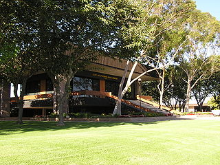
Stanford is a census-designated place (CDP) in the northwest corner of Santa Clara County, California, United States. It is the home of Stanford University. The population was 21,150 at the 2020 census.
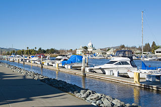
Suisun City is a city in Solano County, California, United States. The population was 29,518 at the 2020 census.
West Sacramento is a city in Yolo County, California, United States. The city is separated from Sacramento by the Sacramento River, which also separates Sacramento and Yolo counties. It is a fast-growing community; the population was 53,915 at the 2020 census, up from 48,744 at the 2010 census. The traditional industrial center of the region since the Gold Rush era, West Sacramento is home to a diverse economy and is one of the area's top four employment centers.
Eagle is a city in Ada County, Idaho 10 miles (16 km) northwest of Boise. The population was 30,346 at the 2020 census.
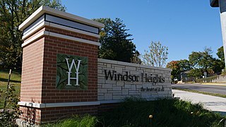
Windsor Heights is a city in Polk County, Iowa, United States. The population was 5,252 at the time of the 2020 census. It is part of the Des Moines–West Des Moines Metropolitan Statistical Area.