Los Angeles County, officially the County of Los Angeles, and sometimes abbreviated as L.A. County, is the most populous county in the United States, with 9,861,224 residents estimated in 2022. Its population is greater than that of 40 individual U.S. states. Comprising 88 incorporated cities and many unincorporated areas within a total area of 4,083 square miles (10,570 km2), it is home to more than a quarter of Californians and is one of the most ethnically diverse U.S. counties. The county's seat, Los Angeles, is the second most populous city in the United States, with 3,822,238 residents estimated in 2022.

Ladera Heights is a community and unincorporated area in Los Angeles County, California. The population was 6,634 at the 2020 census. Culver City lies to its west, the Baldwin Hills neighborhood to its north, the View Park-Windsor Hills community to its east, the Westchester neighborhood to its south and southwest and the city of Inglewood to its southeast. With an average household income of $132,824, Ladera Heights ranks third amongst the ten wealthiest Black communities in the United States.

Marina del Rey is an unincorporated seaside community in Los Angeles County, California, with an eponymous harbor that is a major boating and water recreation destination of the greater Los Angeles area. The port is North America's largest man-made small-craft harbor and is home to approximately 5,000 boats. The area is a popular tourism destination for both land and water activities such as paddle board and kayak rentals, dining cruises, and yacht charters. Land activities include bicycling on several bicycle paths, walking paths along the waterfront, and birdwatching (birding). Wildlife watching opportunities include California sea lions and harbor seals. Dolphins and whales occasionally visit the deeper waters of harbor. This Westside locale is approximately 4 miles (6.4 km) south of Santa Monica, 4 miles (6.4 km) north of Los Angeles International Airport, and 12.5 miles (20.1 km) west-southwest of Downtown Los Angeles.

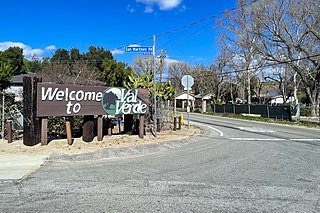
Val Verde is an unincorporated community in the southeastern Topatopa Mountains foothills, and in northwestern Los Angeles County, California. The unincorporated community of Valencia is southeast, and the city of Santa Clarita is east of the community. Its population was 2,468 at the 2010 census, up from 1,472 at the 2000 census. For statistical purposes the Census Bureau has defined Val Verde as a census-designated place (CDP).

Del Sur is an unincorporated community in the Mojave Desert, in Los Angeles County, California. The town has a population of about 1,750. The ZIP Code is 93536 and the community is inside area code 661.

Llano is an unincorporated community located in Los Angeles County, California, United States, near the San Bernardino County line. The town has a population of about 1,200.

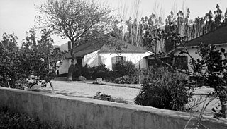
Rancho Camulos, now known as Rancho Camulos Museum, is a ranch located in the Santa Clara River Valley 2.2 miles (3.5 km) east of Piru, California and just north of the Santa Clara River, in Ventura County, California. It was the home of Ygnacio del Valle, a Californio alcalde of the Pueblo de Los Angeles in the 19th century and later elected member of the California State Assembly. The ranch was known as the Home of Ramona because it was widely believed to have been the setting of the popular 1884 novel Ramona by Helen Hunt Jackson. The novel helped to raise awareness about the Californio lifestyle and romanticized "the mission and rancho era of California history."

Los Angeles Athletic Club (LAAC) is a privately owned athletic club and social club in Los Angeles, California, United States. Established in 1880, the club is today best known for its John R. Wooden Award presented to the outstanding men's and women's college basketball player of each year.
Cerrito, Cerritos, El Cerrito, or Los Cerritos may refer to:

Ygnacio Ramón de Jesus del Valle was a Californio ranchero and politician. He owned much of the Santa Clarita Valley and served briefly as Mayor of Los Angeles and as a California State Assemblyman.

Rancho San Francisco was a land grant in present-day northwestern Los Angeles County and eastern Ventura County, California. It was a grant of 48,612 acres (19,673 ha) by Governor Juan B. Alvarado to Antonio del Valle, a Mexican army officer, in recognition for his service to Alta California. It is not related to the city of San Francisco.
Rancho El Tejón was a 97,617-acre (395.04 km2) Mexican land grant in the Tehachapi Mountains and northeastern San Emigdio Mountains, in present-day Kern County, California. It was granted in 1843 by Governor Manuel Micheltorena to José Antonio Aguirre and Ygnacio del Valle.
Rancho Temescal was a 13,339-acre (53.98 km2) Mexican land grant in present-day Ventura County and Los Angeles County, California given in 1843 by Governor Manuel Micheltorena to Francisco Lopez and José Arellanes. The word “temescal” is Spanish for "sweat bath" or "sweat lodge", deriving from the Nahuatl “temazcalli”. The grant was located in the upper end of the Santa Clara Valley, in the eastern section of Ventura County, in the upper Santa Clara River Valley near the base of the Topatopa Mountains where Piru Creek and the Santa Clara River meet. The grant encompassed present-day Lake Piru and town of Piru.
Rancho San José del Valle was a 26,689-acre (108.01 km2) Mexican land grant in present-day San Diego County, California given in 1840 by Governor Juan B. Alvarado to José Antonio Pico, and then given in 1844 by Governor Manuel Micheltorena to Juan José Warner. The most northeasterly grant made within present-day San Diego County, it was bounded on the west by Palomar Mountain, and on the south by Buena Vista Creek and Rancho Valle de San Jose, and encompassed present-day Warner Springs. The western part of the grant is under the waters of Lake Henshaw, formed in 1922 by a dam on the San Luis Rey River.

Reginaldo Francisco del Valle was a Californio statesman and lawyer, who served as a member of the California Senate and California Assembly. He was the youngest ever President pro tempore of the California Senate and was instrumental in the foundation of the institution today known as the University of California, Los Angeles.
Narciso Botello was a chief of staff for Mexican General Joaquín Ramírez y Sesma before the Mexican–American War and was the first Southern California member of the California State Assembly after California organized its legislature.

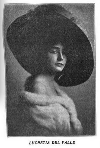
Lucretia del Valle Grady was a Californio political activist, suffragette, and actress. Born to Reginaldo Francisco del Valle, noted Angelino statesman, Lucretia became an important Democratic Party official, serving as vice chair of the Democratic National Committee and as delegate for California to the Democratic National Conventions of 1928, 1936, 1940, and 1956.

Ysabel del Valle was a philanthropist and rancho owner, and the matriarch of a large Californio family. She was a model for the rancho matron character "Señora Moreno" in Helen Hunt Jackson's novel Ramona (1884).
Plaza Del Valle is an outdoor lifestyle center located in a retail and entertainment complex in Panorama City, California, United States, built, managed, and operated by Agora Realty and Management Inc.. It has now become a tourist destination as it is located in the heart of the San Fernando Valley.


