
El Dorado County, officially the County of El Dorado, is a county in the U.S. state of California. As of the 2010 census, the population was 181,058. The county seat is Placerville.
Merced County, is a county located in the northern San Joaquin Valley section of the Central Valley, in the U.S. state of California.
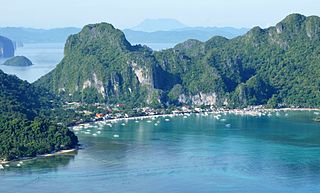
El Nido, officially the Municipality of El Nido, is a 1st class municipality in the province of Palawan, Philippines. According to the 2015 census, it has a population of 41,606 people.
The Amazing Race 5 is the fifth installment of the American reality television show The Amazing Race. The Amazing Race 5 featured 11 teams of two, with a pre-existing relationship, in a race around the world.

Chimichanga is a deep-fried burrito that is common in Tex-Mex and other Southwestern U.S. cuisine. The dish is typically prepared by filling a flour tortilla with various ingredients, most commonly rice, cheese, beans, and a meat such as machaca, carne adobada, carne seca, or shredded chicken, and folding it into a rectangular package. It is then deep-fried, and can be accompanied by salsa, guacamole, sour cream, or carne asada.
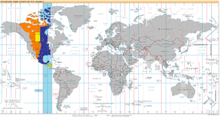
UTC−06:00 is an identifier for a time offset from UTC of −06:00. In North America, it is observed in the Central Time Zone during standard time, and in the Mountain Time Zone during the other eight months. Several Latin American countries and a few other places use it year round.

State Route 59 is a state highway in the U.S. state of California located entirely in Merced County. It connects State Route 152 near El Nido to the city of Merced and beyond, ending abruptly at the intersection of County Routes J59 and J16 in Snelling.

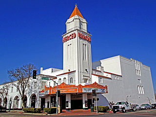
El Nido is a census-designated place in Merced County, California. It is located 15 miles (24 km) west-southwest of Le Grand, at an elevation of 141 feet, and a population of 160 The population was 330 at the 2010 census.

Plaster City is an unincorporated community in Imperial County in the U.S. state of California. It is located 17 miles (27 km) west of El Centro, at an elevation of 105 feet.

El Nido Airport, also known as Lio Airport, is an airport serving the general area of El Nido, located in the province of Palawan in the Philippines. It is located in the barangay of Villa Libertad, about 4 kilometres (2 mi) from the poblacion of El Nido. This concrete airstrip is owned and operated by AirSWIFT. The gravel runway is now partially coated and used as a taxiway for aircraft.
Rio Nido, California is a small, unincorporated resort community on the Russian River, in Sonoma County, California, United States. It is situated 1.3 mi (2.1 km) east of Guerneville. The town's name is meant to mean "river nest" in Spanish. One account has it that the name was originally the more grammatically correct "El Rio Del Nido", "referring to the nest of an eagle once seen in a tree on the banks of this stream". Rio Nido's unofficial slogans are "Memories That Linger" and "The Moon Is Always Out In Rio Nido".
American Chileans and Canadian Chileans are among roughly 300,000 Chileans of North American ancestry. 19th century settlement and land speculation deals brought tens of thousands of Americans to Chile with the rest of Central and South America.

Buena Suerte, or more known as Zone II, is one of the eighteen barangays comprising the Municipality of El Nido in the province of Palawan in the Philippines. Its name literally means "Good Luck" in Spanish.

Xochistlahuaca Municipality is one of the 81 municipalities of Guerrero, in south-western Mexico. The municipal seat lies at Xochistlahuaca. The municipality covers an area of 321.1 km².
Monte Nido is an unincorporated community in western Los Angeles County, California, United States. Monte Nido is located in the Santa Monica Mountains 3 miles (4.8 km) north of Malibu.
Kevet is an unincorporated community in Ventura County, California, United States. The community is on California State Route 126 at the eastern border of Santa Paula.
Manzanita is an unincorporated community in San Diego County, California, United States. The community is at the junction of Interstate 8 and California State Route 94 17.5 miles (28.2 km) southeast of Pine Valley.
Pala Mesa is an unincorporated community in San Diego County, California, United States. The community is at the junction of Interstate 15 and California State Route 76, 11.1 miles (17.9 km) south of Temecula.


