
Los Angeles County, officially the County of Los Angeles, and sometimes abbreviated as L.A. County, is the most populous county in the United States, with 9,861,224 residents estimated in 2022. Its population is greater than that of 40 individual U.S. states. Comprising 88 incorporated cities and many unincorporated areas within a total area of 4,083 square miles (10,570 km2), it is home to more than a quarter of Californians and is one of the most ethnically diverse U.S. counties. The county's seat, Los Angeles, is the second most populous city in the United States, with about 3.9 million residents.
Avocado Heights is an unincorporated census-designated place (CDP) in the San Gabriel Valley of Los Angeles County, California, United States. It is almost entirely surrounded by the City of Industry with only a small strip of unincorporated Los Angeles County separating it from South El Monte. It is in close proximity to both the Pomona (SR-60) and San Gabriel (I-605) freeways. To the west is the San Gabriel River and the California Country Club. Avocado Heights is approximately 15 miles (24 km) from the downtown Los Angeles Civic Center. The population was 15,411 at the 2010 census, up from 15,148 at the 2000 census.
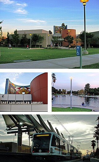
East Los Angeles, or East L.A., often referred to by locals as "East Los", is an unincorporated area in Los Angeles County, California, United States. For statistical purposes, the United States Census Bureau regards East Los Angeles as a census-designated place (CDP). As of the 2020 census it had a population of 118,786, a drop of 6.1% from 2010, when the population was 126,496.

City of Industry is a city in the San Gabriel Valley, in eastern Los Angeles County, California, United States. The city is almost entirely industrial, containing over 3,000 businesses employing 67,000 people, with only 264 residents as of the 2020 census, making it the third least populous city in the state. It was incorporated on June 18, 1957, and has become the economic hub for the San Gabriel Valley.
La Habra Heights is a city in Los Angeles County, California, United States. The population was 5,325 at the 2010 census, down from 5,712 at the 2000 census. La Habra Heights is a suburban canyon community located on the border of Orange and Los Angeles counties. The zoning is 1-acre (4,000 m2) lots with a variety of home and ranch style properties. La Habra Heights features open space and there are no sidewalks in the community. La Habra Heights has no commercial activity with the exception of a small real estate office, a plant nursery, a private golf course and numerous home-based businesses. Hacienda Park is the main park in the city and runs along Hacienda Road. A related city, La Habra, is located south of La Habra Heights and is in Orange County.

La Puente is a city in Los Angeles County, California, United States. The city had a population of 39,816 at the 2010 census and is approximately 20 miles (32 km) east of downtown Los Angeles.

Ladera Heights is a community and unincorporated area in Los Angeles County, California. The population was 6,634 at the 2020 census. Culver City lies to its west, the Baldwin Hills neighborhood to its north, the View Park-Windsor Hills community to its east, the Westchester neighborhood to its south and southwest and the city of Inglewood to its southeast. With an average household income of $132,824, Ladera Heights ranks third amongst the ten wealthiest Black communities in the United States.

Rowland Heights is an unincorporated area in and below the Puente Hills in the San Gabriel Valley, in Los Angeles County, California, United States. The population was 48,231 at the 2020 census. Rowland Heights is in the Los Angeles metropolitan area and represented by the County of Los Angeles and is the largest census designated place in Los Angeles County by area and the county's fourth largest CDP by population. The area has a high Taiwanese population and was known as “Little Taipei” in the 1980s and 1990s, when it saw an influx of wealthy immigrants from Taiwan.

West Covina is a suburban city in Los Angeles County, California, United States. Located 19 miles (31 km) east of Downtown Los Angeles in the eastern San Gabriel Valley, it is part of Greater Los Angeles. The population for the city was 106,098 at the 2010 census.

West Puente Valley is an unincorporated community and census-designated place in Los Angeles County, California, USA, northwest of La Puente. The population was 22,636 at the 2010 census, up from 22,589 at the 2000 census. The community is probably named for its location related to the city of La Puente.

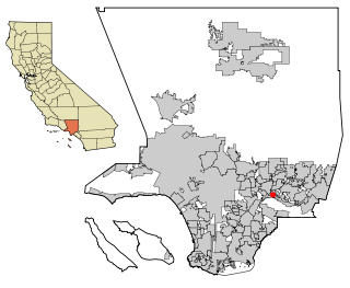
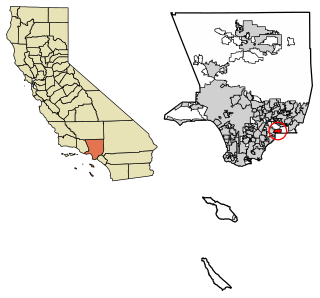
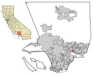
Hacienda Heights is an unincorporated suburban community in Los Angeles County, California, United States. As of the 2010 census, the community had a total population of 54,038, up from 53,122 at the 2000 census. For statistical purposes, the Census Bureau has defined Hacienda Heights as a census designated place (CDP). It is the second largest CDP in Los Angeles County by area, behind Topanga, and the county's fourth largest CDP by population.

The San Gabriel Valley, often referred to by its initials as S.G.V., is one of the principal valleys of Southern California, lying immediately to the east of the eastern city limits of the city of Los Angeles and occupying the vast majority of the southeastern part of Los Angeles County, California. Surrounding features include:

Pico-Union is a neighborhood in Central Los Angeles, California. The name "Pico-Union" refers to the neighborhood that surrounds the intersection of Pico Boulevard and Union Avenue. Located immediately west of Downtown Los Angeles, it is home to over 40,000 residents.

The Asian-American influx to the San Gabriel Valley grew rapidly when Chinese began settling in Monterey Park, California, in the western San Gabriel Valley in the 1970s. Just east of Los Angeles, the region has achieved international prominence as a hub of overseas Chinese, or hua qiao. Although Chinese immigrants were a noteworthy presence in the establishment of Southern California from the 19th century, significant Chinese migration to suburban San Gabriel Valley coincided with a trend of white out-migration from the 1970s onward. This opened an opportunity for middle-class Asian Americans to begin settling in the San Gabriel Valley.
Bassett is an unincorporated community in the San Gabriel Valley, in Los Angeles County, California, United States, located within the Census-designated places boundaries of Avocado Heights and West Puente Valley. Located in the San Gabriel Valley, the ZIP Code is 91746 and the community is inside area code 626.

Los Altos High School is a comprehensive four-year public education high school located in the bedroom community of Hacienda Heights, California, United States, in eastern Los Angeles County. It should not be confused with the Los Altos High School located in the city of Los Altos, California.
Valley Boulevard is a street in Southern California, running east from Los Angeles to Pomona, where it becomes Holt Boulevard, and a continuation from Fontana to Colton. It generally parallels Interstate 10 (I-10) and State Route 60 (CA 60), and is the original alignment of U.S. Route 60 (US 60). The present north end of I-710 is at Valley Boulevard in Los Angeles, just west of Alhambra.
The Hacienda La Puente Unified School District (HLPUSD) is a school district located in Southern California. It is the largest school district in the east San Gabriel Valley in terms of student population, serving 20,000 students from the unincorporated community of Hacienda Heights, portions of the cities of Industry, La Puente and West Covina and portions of the unincorporated communities of Avocado Heights, Valinda and West Puente Valley. The district's headquarters are located in the city of Industry.

Glen A. Wilson High School is a public high school located in Hacienda Heights, California. It is one of two high schools located in the unincorporated community, and one of four in the Hacienda La Puente Unified School District.

Rowland Unified School District is a school district in the San Gabriel Valley, Los Angeles County, California. Its headquarters are in Rowland Heights, an unincorporated area in the county.

